Welcome to SENDITUR.COM · paths · routes · tourism


Today, technology has become part of our mountain and trekking activities, helping us, for example, to know and share our location in a quick, simple and exact way, providing us with greater security on the routes and giving us data and information with hardly any technical knowledge. GPS devices and applications that turn our cell phone or tablet into an advanced navigation system. It is important to know how to use them and how they work so that, if necessary, we have correct data to help us solve the situation in which we find ourselves.

But before starting with the handling of the GPS let's see the basic knowledge that we have to have for the correct use of these devices, it is not irrelevant to review a series of tips and recommendations that will help us avoid errors and clarify confusion:


The Global Position System allows a hiker or mountaineer to know at all times and with great accuracy his position, to go to any point where he knows his coordinates or follow a certain route through his GPS device. This system, developed in the early 70's for war purposes, has become a public system used by millions of people around the world, and knowing its basic operation and limitations will be of great help to us on our routes.
GPS obtains our position by receiving a series of radio signals emitted by a network of satellites orbiting the earth at a given distance. There are several different satellite systems such as NAVSTAR or GLONASS.
To calculate our position and height it is necessary to have at least the signal of 4 satellites that serve to know the distance that separates us from them so that the GPS can triangulate our location.
There are a number of factors that affect the accuracy of the location shown by the device:

At present we have different systems of satellites in fixed orbit, such as the WAAS system and the EGNOS, which improve and increase the precision of the position we obtain.

The data of our position are georeference coordinates that the GPS shows, so we must master some basic concepts of mapping and orientation. Our GPS can show us the data of position in different formats (DDºMM'MMM'', MGRS, UTM, etc...) the model of projection of the cartography used in Spain and more advisable for the outdoor is the UTM (Universal Transversal Mercator).
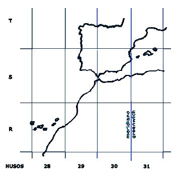
This system divides the earth plane into squares by means of transversal and longitudinal bands, which gives us a total of 60 spindles and 20 transversal bands identified from C to X. The Iberian Peninsula is positioned between spindles 29, 30 and 31, and bands S and T.
As a general rule, any topographic map that includes the UTM kilometer grid will also provide us with the spindle, so we will only have to obtain the X and Y coordinates corresponding to the equator and the meridian respectively but from the grid we are on. From there the format of these coordinates 30T (spindle and band) 512733 (X distance from the equator) 4649628 (Y distance from the meridian).
It is important to know that the coordinates are always subject to a DATUM, which takes into account the irregularities of the earth's surface in each region.
Until relatively recently the reference DATUM was EUR 50 but this has been replaced by the ETRS 89 which covers the whole of the European Union. It happens that in many GPS models this DATUM does not appear, we do not have to worry because the WGS84 is the same as the ETRS 89, with minimal differences that in the normal use that we are going to make we will not appreciate.
It is tremendously important to configure this section of our GPS and position it in the DATUM of the map that we have loaded on it, because if we do not we can find differences of more or less 200 m with the real location in which we are.
Once we have these basic concepts clear, we will have to configure our GPS to avoid erroneous measurements due to incorrect settings.
Getting hold of the device, knowing how to create a point of interest, reset the navigation data or save the track log of our route among other functions is something we cannot leave for when we are in the middle of a blizzard or soaked by the storm.
Broadly speaking, our GPS not only gives us the position in which we are, but also allows us to perform different navigation techniques:

The track of a route is like the breadcrumbs joined together that mark the route to be followed. We can find track of the routes in internet that will serve us to prepare the activity, to verify its validity and to orient us in case of necessity once installed in our GPS. But it is very important that we always follow a series of guidelines to increase safety:

Very basic concepts that will help us to better understand the instruction manual of our GPS and that we can expand in some of the many manuals or courses that with practice and more content, will help us to master more fluently a tremendously useful tool when needed and that surely will encourage us to learn more about orientation and use of the map and compass, which we do not have to leave aside.

We would be grateful if you could write to us to inform us of a ny erroneous or outdated information you have found, or simply to let us know what you think at Thank you very much.


