Welcome to SENDITUR.COM · paths · routes · tourism

![]() Difficulty-Moderate
Difficulty-Moderate
![]() 5:00 h.
5:00 h.
![]() 14 km.
14 km.
![]() Difficulty-Moderate
Difficulty-Moderate
![]() 5:00 h.
5:00 h.
![]() 14 km.
14 km.
In the Alicante region of the Marina Alta, specifically in the Vall de Laguar, a natural landscape of great beauty awaits us and the route that runs through it, we are talking about the Barranc de I'Infern, the cathedral of hiking. Every self-respecting hiker should not miss this famous route, which is said to owe the grandeur of its name to the more than 6500 steps that make it up and that help us to overcome the great unevenness of the route. This route follows the PR-CV 147 signposting, starting from the town of Fleix and also passing through Benimaurell, another possible starting point for this path of steps.
There are several possible ways to get to Fleix, although the main accesses are found on the road that connects Castell de Castells and Parcent or on the road that links the latter with Pego. Of course, we can also get there from Vall de Ebo, among many other options.
The most common starting point is in the town of Fleix, where there are both parking areas and signs with information about the route. Another possibility is in the village of Benimaurell, as the route also passes through it and you should have no major problems parking and joining it.
On the outskirts of the village of Fleix (0h 00min), on the road that leads to Benimaurell, you find a large parking area where the route along the Barranco del Infierno starts. Follow this road a few metres towards Benimaurell to find the turn-off that you should follow. The path takes you down to the Font Grossa and the old Fleix washing place. A little further on, the path begins, which we must follow, leaving the road we will return along.
From here we can already see the winding route that awaits us.
The descent takes us through the Forat de la Juvea pass, a tunnel excavated in the rock that allows us to overcome the vertical cut that we have next to us. This architectural work, the more than 6500 steps and the tunnel, along with other remains, were made by the Moors as paths to cross these abrupt lands when they inhabited this area of the Peninsula. We leave behind this spectacular pass to continue descending in search of the bed of the Girona river, which has been responsible for shaping this rugged ravine. The route markers and the path lead us without major complications to the river bed itself, which is usually dry, we are in the middle of the Barranc de l'Infern.
We cross the riverbed to begin one of the demanding sections that we will have to overcome. The path, of course, zigzags along the side of the ravine, making us gain height quickly. Once again the steps are the protagonists, although at this stage of the route we have lost count of how many we have already climbed. After a while, the slope gives us a break as we approach a group of houses known as Juvees d'Enmig, a good place to take a break and regain our strength.
We leave this welcoming spot behind us to begin a new descent that takes us first to the Font de Reinós. After the pertinent stop, we continue our descent to hell. A descent that ends when we come across the dry riverbed, which we go up a few metres in search of the beginning of the ascent that awaits us. Once again, a demanding ascent that, after several zigzags and several stops to catch our breath and enjoy the landscape, takes us to another of the old groups of buildings that populate the area, the Juvees de Dalt. This area offers unbeatable views of the Barranc de I'Infern ravine, views that we enjoy as we prepare for a new stretch of descent. This part of the route takes us through the Barranc del Tuerto or Barranc dels Torts. This ravine takes us directly to the Racons ravine, the starting point of the last uphill stretch that we will have to face.
Once again, the path zigzags around countless switchbacks that make us gain height with each step. Little by little we leave the ravine without being able to stop looking back to contemplate the spectacular landscape that we are crossing. After a while, our path reaches its end, leaving us on an asphalted track along which we must continue. The Font dels Olbis invites us to take a break before tackling the final stretch of the route. Benimaurell (4h 35min) awaits us a little further on to take us out of the hell we have been through.

Barranc de I’Infern-CC/Pacopac

Barranc de I’Infern-CC/Pacopac
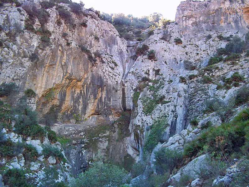
Barranc de I’Infern-CC/Pacopac

Barranc de I’Infern-CC/Pacopac
We cross the town in search of the road that comes from Fleix, but just before we reach the exit we come across the cement road that we followed at the beginning of our route. This path takes us without major complications to Fleix (5h 00min) where we will put an end to this beautiful hiking route, which has more than deserved to be called the Cathedral of Hiking.
1-Technically, it is not a technically complicated route, although you must be careful in the narrower or more exposed areas.
2-The physical demand is high, both in terms of the slope to be overcome and the number of steps involved.
3-There is virtually no shade along the entire route, so the heat is not a good companion for adventures on this route.
4-Pay attention to the weather, in rainy periods or stormy days the riverbeds are not very advisable, and we cross the bed of the Isbert reservoir.
5-Take plenty of water and some food, and of course be properly equipped.
 |
 |
 |
 |
 |
| 1-Fleix | 0:00h | 445m | 0km | 30S 751017 4296116 |
| 2-Benimaurell | 4:35h | 540m | 12Km | 30S 749565 4295567 |
Coordinates UTM Datúm WGS84

.png) Distance: 14Km
Distance: 14Km
.png) Time: 5:00h
Time: 5:00h
.png) Difficulty: Moderate
Difficulty: Moderate
 Slope: 1680m
 Slope +: 840m
 Slope -: 840m
 Maximum altitude: 605m
 Minimum altitude: 180m

![]()
This schematic with the path is approximate and has been created from the derived cartographic base © Instituto Geográfico Nacional "Cuadrante 822-1 1:25.000".

¿Did you know that...
This route has several different names, from the official path PR-CV 147, the Camí de les Jovades, to The Cathedral of Hiking or The Route of the 6500 stone steps.
Don't miss out...
The Barranc del Salt or Barranc de Fleix, which you will find on the first downhill stretch of the route, especially in the Forat de la Juvea area. If you are lucky if it has rained, you will be able to see a beautiful waterfall of approximately 65 m in height.


From the commitment of SENDITUR with Nature and the respect to the balance of the environment, SENDITUR urges you to travel in a responsible way, with low environmental impact and respecting at all times the Natural, Cultural and Social environment wherever you go.

Besides sharing with all of us your experience on the route we would be grateful if you could write to us to inform us of any erroneous or outdated information you may have found, or simply to let us know what you think at Thank you.
Route information updated on 18-11-2020. The route may vary greatly depending on the time of year, weather conditions and terrain, as well as the actions of third parties and the evolution suffered in the natural environment where it is located. All opinions, advice and/or assessments made by SENDITUR in their descriptions are for guidance only and are subject to and/or refer to the specific conditions of the specific day of the route, referring to that specific day, taken from trained people, with the appropriate experience and with a high level of physical and technical preparation as a reference, as well as correctly equipped.
All the times are approximate and take an orientative character, the stops have not been taken into account, no matter how small they are. All the information related to the route, texts, images, videos, maps, diagrams, tracks, towns, and places of tourist interest are published as a guide, and may not coincide with the current state of each place. Before undertaking any activity, assess your technical knowledge, your physical condition, find out about the weather and the variations that the route may undergo, equip yourself correctly, be prudent and responsible at all times, and do not exceed your capabilities. SENDITUR is not responsible for any misuse or inappropriate use of the comprehensive guides of its routes and/or publications as well as its electronic guides, nor for any variations in their descriptions for the aforementioned reasons, and recommends that everyone be responsible and prudent in carrying out the activity. We also encourage you to read books and specialised guides to complement the information described above.
Continue watching …


