Welcome to SENDITUR.COM · paths · routes · tourism

![]() Difficulty-Medium
Difficulty-Medium
![]() 2:45 h.
2:45 h.
![]() 7.8 km.
7.8 km.
![]() Difficulty-Medium
Difficulty-Medium
![]() 2:45 h.
2:45 h.
![]() 7.8 km.
7.8 km.
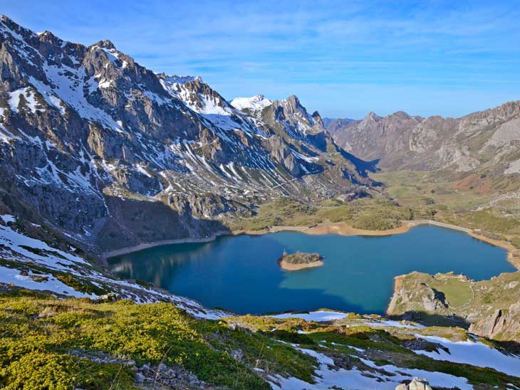
Asturias offers nature, mountain and hiking lovers an infinite number of places and routes to enjoy. Perhaps one of the most impressive places to visit in Asturias is the Somiedo Natural Park, where numerous routes and charming spots await us. One of the most visited routes is undoubtedly the circular route of the Saliencia Lakes, an itinerary that allows us to travel through this area of the natural park and discover the different lakes that await us there. Of glacial origin, the lake of the Cave, the Lake of the Mine or Almagrera, the Lake of Cerveriz or Cerveiriz and the Lake of Calabazosa or Black Lake form the Lakes of Saliencia, and together with the nearby Lake of the Valley they receive the name of the Lakes of Somiedo.
You can imagine that there are several routes through this natural landscape, although most of them start from the High of the Farrapona, which is the usual finish for one of the most popular stages of the Vuelta Ciclista to Spain. The best way to reach the High of the Farrapona is to follow the route taken by the cyclists to reach the top of the mountain pass. This mountain pass is the natural border between Asturias and León, but the León side is an unconditioned road that is not very suitable for cars, so we must be careful with navigators such as Google Maps as, depending on our point of origin, they can put us on this road, complicating our arrival. The best option is to head towards the town of Pola de Somiedo, as it is between this town and Castro where we will find the road that climbs up the Saliencia Valley, passing through the towns of Veigas, Villarín, Arbellales, Endriga and Saliencia itself. From there we will continue ascending until we reach the High of the Farrapona, the end of the asphalted road, where we will find a car park that tends to fill up quickly on the busiest days.
The High of the Farrapona parking is the starting point of our circular route of the Saliencia Lakes in Somiedo. As we have already mentioned, there are several routes that we can do in the Somiedo Lakes, allowing us to adapt the itinerary to our tastes and abilities. Most of them share part of the same route, each one being an extension of the previous one. Another option, the most demanding in terms of distance and slope, links the High of the Farrapona with the town of Valle de Lago, another of the starting points for visiting the Somiedo Natural Park. In any case, we leave the car park behind us to follow the signs and the path that descends the valley, parallel to the road we arrived on. The comfortable path makes us lose altitude flanked by the vertical walls of the mountains that hide the Somiedo Lakes. Almost without noticing it, the Lake of the Cave (0h 20min), the first of the lakes of Saliencia, appears in front of us.
We leave aside the path that descends to the Lake of the Cave, where we will return at the end of the route, to head towards the Viewpoint of the Peña la Cueva, where we will find an informative sign that will help us to better understand this magnificent spot and its peculiarities.
We continue along the route skirting the lake, cutting through the side of the mountain that marks it on this side, and we can't help but enjoy the views that surround us at all times.
The path seems to make us say goodbye to this spot, but some stones that act as a barrier quickly cut it off, forcing us to turn almost round and face the ascent that will take us out of the natural pool where the lake is located. The tough ascent is an excuse to make the occasional stop to catch our breath and contemplate the remains of the old Santa Rita Mine. Almost at the end of the ascent we reach the lake of the Mine or Almagrera (1h 05min), the smallest of all the lakes of Somiedo and the one we are most likely to find without water in the middle of summer.

Calabazosa Lake-CC/Andrea Valsecchi

Cave Lake-CC/Gongniu

Cerveriz Lake-CC/Javier Pérez
We continue the route, leaving the Lake of the Mine to our left, to go up the slope that separates us from the Vega or Meadow of Cerveriz. A green pasture to which we descend and where we can already contemplate the Cerveriz Lake. In the middle of the meadow the route forces us to decide between following the path to the left and approaching the Cerveriz Lake (1h 25min), or continuing straight on across the meadow towards the Lake of the Valley, a very interesting option that considerably increases the distance to be covered.
On this occasion attracted by the enchantment of the vertical walls of the Peaks Albos we head for the edge of the Cerveriz Lake to meet the head of the old glacial moraine that separates it from our next objective. There are several stony paths that allow us to overcome this ledge and descend to the edge of the lake of the Calabazosa (1h 40min), which we border leaving it to our left.
As you can imagine, once you have visited this last lake of Saliencia you can retrace your steps. In our case we border the lake almost completely. When the path seems to want to take us back towards the moraine, but on the other side of the lake, we will leave the path behind us to start the ascent that will take us out of the hole where the Black Lake is located, as it is also known. This lake is the deepest of all the lakes in Somiedo, a depth that obscures its waters, hence its second name.
Once again, this somewhat demanding path takes us up the cliff that separates Calabazosa from Lake of the Cave, which we will be able to see again once we have passed this steep slope.
All that remains is to follow the path that cuts through the mountainside and crosses one of the ravines that feed water to the lake. Once we have crossed it, we descend little by little without ever reaching the shore of the lake, and after passing through a rocky area we reach the huts that we left to one side at the beginning of the route when we first arrived at the lake. From here we only have to walk the path that separates us from the parking of High of the Farrapona (2h 45min), where we will put an end to this hiking route through the Natural Park of Somiedo.
1-Bear in mind that throughout this area, especially around the lakes, there are countless trails that allow you to vary and adapt the route to your liking, extending or reducing the total distance.
2-From the Cerveriz Meadow to the Lake of the Valley you have just over 5 km, one way, although it is not necessary to go to the lake as from the Llomba de Camayor, about 3 km from the meadow, you can contemplate the Lake of the Valley and the valley of Lago itself in all its splendour.
3-Bear in mind that although this is an initially simple route, it runs at an altitude of over 1600m, where the weather changes rapidly and almost without warning, so even in the middle of summer don't be overconfident.
4-This entire route runs within the Somiedo Natural Park, which has a series of mandatory rules to contribute to its conservation.
 |
 |
 |
 |
 |
| 1-High of the Farrapano | 0:00h | 1710m | 0Km | 29T 736993 4771254 |
| 2-Lake of the Cave | 0:20h | 1605m | 1,3Km | 29T 735936 4771139 |
| 3-Lake of the Mine | 1:05h | 1730m | 2,4Km | 29T 735468 4770780 |
| 4-Lake of Cerveriz | 1:25h | 1660m | 3,5Km | 29T 735176 4770415 |
| 5-Lake Calabazosa | 1:40h | 1640m | 4,4Km | 29T 735914 4769922 |
Coordinates UTM Datúm WGS84

.png) Distance: 7,8Km
Distance: 7,8Km
.png) Time: 2:45h
Time: 2:45h
.png) Difficulty: Medium
Difficulty: Medium
 Slope: 790m
 Slope +395m
 Slope -395m
 Maximum altitude: 1745m
 Minimum altitude: 1600m

![]()
This schematic with the path is approximate and has been created from the derived cartographic base © Instituto Geográfico Nacional "Cuadrante 77-31:25.000".

The church of the 365 corners, as many as the days of the year


A journey into the entrails of the Asturian mines

¿Did you know that...
The Santa Rita mine was active until 1978, being owned by the company Mines of Somiedo S.A. Here, oligist or hematite, the ore from which iron is extracted, was extracted.
Don't miss out...
The famous Cabanas de Teito of Somiedo, made of stone and with a broom roof, can be seen in a large part of the Saliencia valley. These are the typical constructions used by the "vaqueiros de alzada" who looked after the livestock in the mountains.


From the commitment of SENDITUR with Nature and the respect to the balance of the environment, SENDITUR urges you to travel in a responsible way, with low environmental impact and respecting at all times the Natural, Cultural and Social environment wherever you go.

Besides sharing with all of us your experience on the route we would be grateful if you could write to us to inform us of any erroneous or outdated information you may have found, or simply to let us know what you think at Thank you.
Route information updated on 06-06-2021. The route may vary greatly depending on the time of year, weather conditions and terrain, as well as the actions of third parties and the evolution suffered in the natural environment where it is located. All opinions, advice and/or assessments made by SENDITUR in their descriptions are for guidance only and are subject to and/or refer to the specific conditions of the specific day of the route, referring to that specific day, taken from trained people, with the appropriate experience and with a high level of physical and technical preparation as a reference, as well as correctly equipped.
All the times are approximate and take an orientative character, the stops have not been taken into account, no matter how small they are. All the information related to the route, texts, images, videos, maps, diagrams, tracks, towns, and places of tourist interest are published as a guide, and may not coincide with the current state of each place. Before undertaking any activity, assess your technical knowledge, your physical condition, find out about the weather and the variations that the route may undergo, equip yourself correctly, be prudent and responsible at all times, and do not exceed your capabilities. SENDITUR is not responsible for any misuse or inappropriate use of the comprehensive guides of its routes and/or publications as well as its electronic guides, nor for any variations in their descriptions for the aforementioned reasons, and recommends that everyone be responsible and prudent in carrying out the activity. We also encourage you to read books and specialised guides to complement the information described above.
Continue watching …

.jpg "Go to Taramundi Water Route")


