Climb to Sampol and La Picota or El Hermoso
A colorful route that shows us magnificent balconies
A colorful route that shows us magnificent balconies
Marking the limits of the Sierra of La Demanda and being a natural border between La Rioja and Burgos, we find the Ayago Mounts, a mountainous system whose peaks hardly exceed 1000 m of altitude but which offer us a wonderful mixture of exuberant nature and magnificent views. Some of its main peaks are the Sampol and La Picota or El Hermoso as it is also known, from where we can recreate contemplating Santo Domingo de la Calzada and its region, as well as the Sierra of La Demanda respectively.
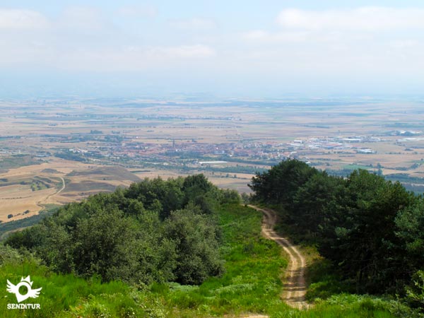
The climb to Sampol and La Picota or El Hermoso with 13.2 km leads us from Morales, at the foot of these peaks, to the limits of the lush forest in which he enters to ascend to them. There are several options that we will have for the ascent, each one with its particularities. One of them leads us through a thick forest of beeches, pines and holm oaks that offer us a marvelous spectacle of colors at the same time that we ascend following the normally dry channel of the Elm stream. At the end of the ascent we will see ourselves following the course of one of the many tracks that arrive here from the different towns that surround us, this track will lead us to the summit of the Sampol or the Lookout of Santo Domingo, as it is also known given the unbeatable views from here of this town and its surroundings.

From the Sampol we will retrace part of what we have walked to go towards the next summit that we will crown, we will leave behind the route that we follow to ascend until this top shoulder where we will arrive at the summit of La Picota, also known as El Hermoso. From this place you can enjoy the unmistakable silhouette of the peaks that are part of the Sierra of La Demanda and the plain that extends to our feet belonging to the province of Burgos. The descent gives us the possibility of contemplating another of the perspectives that this route offers us, showing us the wide valley of the Ebro and in the horizon the steep line that form the Obarenes Mounts, the Sierra of the Toloño and Sierra Cantabria that extend up to where the view reaches us, next to the different localities that populate the valley as Morales where the route ends.

There are many paths and trails that cross this area giving us the option to reach these peaks from many different places. This same allows us, if we know the terrain, to vary the route to our liking extending or shortening the distance to cover since many cases the paths or trails that we are leaving behind us are small shortcuts that come back together with the main road, but given the large number of possible detours is very important to have clear the option to choose not to finish too far from our goal.
The access road to Morales can be found shortly after leaving Santo Domingo de la Calzada following the old route of the N-120 in the direction of Burgos. Once we take this detour, the LR-323 will take us to the locality, passing by Corporales before. Also by this same road but in the opposite direction we can reach Morales from the nearby town of Grañón which is also next to the N-120 between Burgos and Logroño. Once in Morales we will be able to leave our vehicle in the square of the locality that we will find next to the road.
Nice route without great demands or complications, unless we allow our companion to leave the route in which case it is relatively easy to get lost given the leafy areas, which advises a small check at the end of the day for possible parasites that the shrubs may harbor.
Without water zones in all the route, except at the beginning, it is advisable to take enough water since the heat can be high depending on the time of the year that we choose to carry out the itinerary. Although this has large areas of shade, the stretches of track between La Picota and Sampol and between La Picota and Morales do not give truce if the sun squeezes.
The area is the habitat chosen by a large number of different species, although it is not usual to find them if we must have their presence, also in hunting season we do not have to forget that we are transiting through a preserve so it is important to inform us before the existence of possible hunts.
In the square of Morales (0h 00min), next to the road of Grañón, begins the route that crosses this road leaving behind the Fountain of the Romeros.

The Calle Real is used to say goodbye to the locality, which we will quickly leave behind.
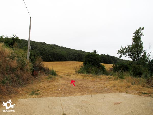
The cement of the street soon gives way to the dirt track that, already in frank ascent, will take us away definitively from the population.
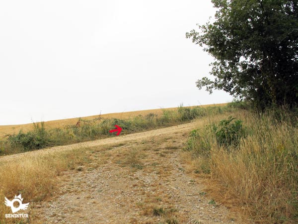
This cobblestone track leads us directly to the path that climbs from Corporales to the mountain. We follow the ascent facing a short but hard ramp that will make us gain the necessary height to enjoy the environment that surrounds us.

In front of us we have a long stretch of perfect track that, without such a marked slope, will take us without detours to the next crossroads where the Bifurcation (0h 35min) of the route is located.

At this point the route is at a crossroads where on our left we will see two options. The one on the right leads directly to La Picota, while the one on the left leads to Sampol.

Both options save the unevenness that separates us from the high area of the mountain although in a different way, one requires us from the beginning a wide effort to overcome the unevenness lowering the intensity as we approach the top, while the other saves for the end the most demanding area.
If we decide to follow the path on the left almost immediately, we will be surrounded by the exuberant vegetation that surrounds most of the route.

Following the path without deviating in the paths or trails less defined that we are crossing, we arrive at the moment in which our track turns sharply to the left.

In front of us we find the possibility of continuing straight on following the path that maintains the line that marks the stream, usually dry, which runs to our left and will accompany us hidden by the vegetation in this part of the journey.

From this point the ascent is gradually gaining intensity without putting us in great difficulty for now. The path, from which we do not have to leave at any time, ascends through the interior of the forest interspersed with areas of good firm with other holes drilled by the water.

The stream gets in our path forcing us to cross it to undertake a hard ramp. The vegetation, which hardly lets even a ray of sunshine through, accompanies us at all times, giving us in very few areas something of margin where we can widen our field of vision.
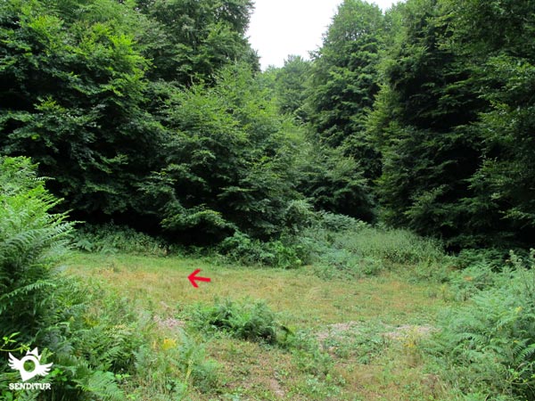
It is in one of these clearings where our path suddenly disappears as if swallowed up by the bushes that surround us. Here in front of us we can see what looks like the trail where the journey continues, although actually our itinerary continues on the left.

Practically hidden by the vegetation we find as soon as we reach this clearing, to our left, the trail where we must continue. This part of the route, although it is usually cleared, alternates areas somewhat covered by vegetation with other more open areas.

Once the footpath is located, a hard stretch awaits us in which to the demanding slope we will have to add the particular struggle to make our way through the ferns that, no matter how much they clear, reclaim their space again.

The well-defined trail makes us gain height quickly, forcing us to take the ascent calmly, giving us the opportunity to enjoy the magnificent forest we are visiting.

After a while we reached the end of this ascent section, at the same time that the trail that brought us to this place comes to an end. To our right there is a wide track waiting for us that cuts through the dense forest we used to walk through.

When going out to the track the route continues through it started then a gradual descent that allows us to recover from the previous effort. This wide track crosses with others, which in turn act as firebreaks, leaving them behind.

When we begin to have the impression that we are heading down the mountain, our track draws a sharp turn, at which point we leave it to continue straight on following the path that begins at that same place.
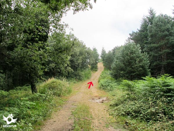
This path leads us quickly to the short but imposing ramp that separates us from the summit of the Sampol (1h 50min), from where, if we go a few meters further along this same path, we can see the unbeatable views of Santo Domingo de la Calzada and its surroundings, from this place.
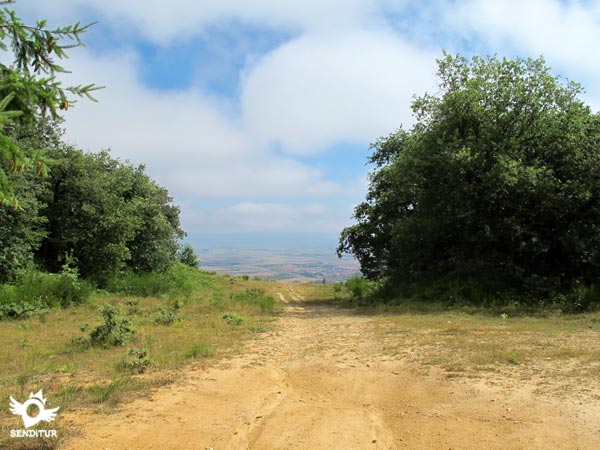
This same path, if followed, would take us without major complications to this very locality.
Once enjoyed the deserved rest we headed to retrace part of what we had walked, returning on our steps.

Again we will see ourselves descending the strong ramp to go towards the wide track that we left before.

Now it's our turn to recover the lost height when we reach it. After a while we arrive at the detour (2h 15min), where the path took us before, here we can decide whether to continue towards La Picota or return descending the steep trail that hides among the vegetation.

The track will take us without major complications until the next summit of the day, but not before leaving to the left and right as many tracks and roads we find.

The route, an uncomfortable ascent and descent, no longer enjoys the pleasant shade that we were able to take advantage of our climb, fortunately we will not have to face any outstanding slope.

It is in one of these crossroads where, now, we will have to deviate to begin the short ascent that separates us from the summit of La Picota or El Hermoso (2h 40min), whose geodesic milestone we can already observe from below, serving as a reference to know when to leave the wide track.
Once we have taken advantage of the location of this summit to contemplate, among many other options, the Sierra of La Demanda, we begin the descent that will take us to the end of the route.

Following the road that brought us here, which borders the milestone, we will see ourselves walking through a pleasant area of soft slides.

Almost at the moment we are in a new crossroads where our route continues for the option of the right of the two that are posed to us, beginning definitively the descent for now soft towards the valley.

An itinerary awaits us with no more detours, which gains inclination as we advance, leaving behind us the paths we find. The route already shows us clearly the strong slope that if we had followed this option at the beginning of the route we would have had to face.
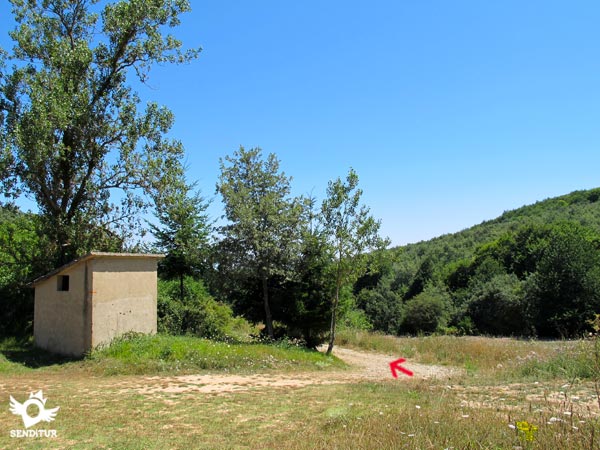
Almost without warning we find ourselves at the bifurcation (3h 20min), where we meet again with the other part of the route. Now with no more variables we just have to follow the route we made at the beginning and that will take us to the detour with the road that leads to Morales (3h 40min).

Where we leave the track that continues its rectilinear course that if we follow it would take us to the town of Corporales.
Return by the same route makes this figure increase significantly.
Regardless of whether we choose one or the other route of ascent, we will not ostensibly see a variation in the total time that we will use for the route. If it is important to bear in mind that inside the forest we will pass through quite dense areas so that when the day falls the visibility will be much less than we might think.
The characteristics of the forest through which the route runs make autumn one of the best times to visit these peaks as we will find a great and striking variety of reddish and ochre accompanying the usual greens of the area. Spring guarantees us the theoretical good weather that allows us to take full advantage of the wide panoramic views that these peaks have. The normally hot summer in these lands invites us to look for the freshness of the interior of the forest from which it will undoubtedly be difficult for us to get out.
It is advisable to wear long pants that protect us from direct contact with shrubs that grow in part of the journey, otherwise except the canteen with water and some food should not highlight anything more than usual. Clothing and footwear according to weather conditions, walking sticks and the usual sunscreen cream, sunglasses and cap or hat. For the large number of paths and trails that we will cross we can not miss the map and compass or failing that the GPS with its corresponding tracks that can serve as a query in case of doubt. Consult our list of material and equipment for hiking. Read more.
Physical
With some ramp of a certain magnitude, the route offers us the possibility of facing it calmly and finding areas where we can recover the forces lost in the strong ascents that are concentrated in certain points. It is not necessary to underestimate the heat that without a doubt will considerably increase the demand of the route.
Severity of the environment
Without difficulties of any kind we will only have to be attentive to avoid slips in the descent of the trail if we decide to go down it. The geodesic vertices are elevated on pillars that in turn are equipped with steps to climb up to them, this is where we must assess the need or not to climb and of course check the status of the steps before climbing them.
Orientation
An unmarked route with multiple crossroads that extend the different possibilities of reaching these summits from different places and that in some cases communicate one route with another. It is therefore advisable not to leave the route we know and always carry with us a map and compass, as well as the GPS with the tracks in case we need it. Even so, as we almost travel along well marked tracks, we should not have any problem to follow the proposed route and orientate ourselves. In case of fog one of the most important reasons to get close to the summits is lost, besides complicating us considerably to maintain the correct course.
| 1-Morales | 0:00h | 773m | 0Km | 30T 499227 4697007 |
| 2-Bifurcation | 0:35h | 877m | 2Km | 30T 498664 4695646 |
| 3-Detour | 1:30h | 1122m | 4Km | 30T 498873 4693788 |
| 4-Sampol | 1:50h | 1087m | 5.5Km | 30T 499536 4694797 |
| 5-Detour | 2:15h | 1122m | 7Km | 30T 498873 4693788 |
| 6-La Picota o El Hermoso | 2:40h | 1158m | 8.6Km | 30T 497705 4693371 |
| 7-Bifurcation | 3:20h | 877m | 11.2Km | 30T 498664 4695646 |
| 8-Morales | 3:40h | 773m | 13.2Km | 30T 499227 4697008 |
Coordinates UTM Datum WGS84

![]() Slope: 1158m
Slope: 1158m
![]() Slope +: 531m
Slope +: 531m
![]() Slope -: 531m
Slope -: 531m
![]() Maximum altitude: 1160m
Maximum altitude: 1160m
![]() Minimum altitude: 733m
Minimum altitude: 733m

This sketch of the route is not made to scale nor does it contain all the information relating to the area, it is merely indicative.

This schematic with the path is approximate and has been created from the derived cartographic base © Instituto Geográfico Nacional "Cuadrante 201-1, 202-2, 202-3 y 202,4 1:25.000"
Senditur has manipulated the tracks to correct the aberrant points that may exist, caused by problems with the reception of the GPS signal. In any case the tracks are always approximate. SENDITUR encourages you to use the new technologies within your reach, using them as support and consultation in your activity, not basing the realization and orientation of the same only and exclusively on them, since they may see their functioning altered by very diverse causes, not functioning correctly and their indications may not be precise.
¿Did you know that...
The Sampol is closely linked to Santo Domingo de la Calzada due to its special location from where it dominates the entire town and its surroundings. This fact has contributed to know this summit as the Viewpoint of Santo Domingo for the panoramic views that can be enjoyed from it.
Don't miss out...
The visit to Santo Domingo de la Calzada and its monumental set in which it is possible to emphasize, among its rich patrimony, its Cathedral whose Tower known as La Moza de La Rioja rises totally separated from it, giving rise to a separate building to the Cathedral.
From the commitment of SENDITUR with Nature and the respect to the balance of the environment, SENDITUR urges you to travel in a responsible way, with low environmental impact and respecting at all times the Natural, Cultural and Social environment wherever you go.
Besides sharing with all of us your experience on the route we would be grateful if you could write to us to inform us of any erroneous or outdated information you may have found, or simply to let us know what you think at Thank you.
This route has been carried out in the field by SENDITUR on 03-08-2015. The route may vary greatly depending on the time of year, weather conditions and terrain, as well as the actions of third parties and the evolution suffered in the natural environment where it is located. All opinions, advice and/or assessments made by SENDITUR in their descriptions are for guidance only and are subject to and/or refer to the specific conditions of the specific day of the route, referring to that specific day, taken from trained people, with the appropriate experience and with a high level of physical and technical preparation as a reference, as well as correctly equipped.
All the times are approximate and take an orientative character, the stops have not been taken into account, no matter how small they are. All the information related to the route, texts, images, videos, maps, diagrams, tracks, towns, and places of tourist interest are published as a guide, and may not coincide with the current state of each place. Before undertaking any activity, assess your technical knowledge, your physical condition, find out about the weather and the variations that the route may undergo, equip yourself correctly, be prudent and responsible at all times, and do not exceed your capabilities. SENDITUR is not responsible for any misuse or inappropriate use of the comprehensive guides of its routes and/or publications as well as its electronic guides, nor for any variations in their descriptions for the aforementioned reasons, and recommends that everyone be responsible and prudent in carrying out the activity. We also encourage you to read books and specialised guides to complement the information described above.
Continue watching …