The valley of the river Salazar extends from the very heart of the Navarrese Pyrenees to the plains of Lumbier, in its course the river has been shaping this prosperous valley forging true works of natural art such as the Foz of Arbayún, a spectacular canyon sculpted by the action of the river for years. This colossal spot, almost impregnable, is reserved for the fauna and flora that inhabit it, making it the wildest and most peculiar of the foces of Navarre.

The route with only 3.6 km brings us from the village of Usún to the southern slope of the Foz de Arbayún, an area in which the river escapes from the prison formed by himself, running calmly towards the wide plains of Lumbier, where just before entering another of the foces of Navarre, that of Lumbier, its almost 34 km of life that began upstream, in the very Irati Forest, ends. The itinerary makes us descend practically to the same bank of the river from where we will be able to scrutinize a small part of the interior of the Foz. A Foz about 6 km long, and thanks to its rugged figure with walls that reach more than 100 m, and narrowness in which the river is only a few meters wide to pass, has retained a habitat almost unchanged by man's hand.

A habitat, home to countless species of animals and plants found in the gorge and its different areas, each with its own microclimate and soil composition, an ideal home to develop. The rock cut are the place chosen by one of the largest colonies of vultures, without forgetting the peregrine falcon, the golden eagle or the chough piquirroja. While the low areas and the banks of the river are chosen by the badger, the roe deer or the wild cat among others. And if the fauna that lives in the gorge is rich, exuberant and diverse is its vegetation, given the different orientations that the river has carved into the rock and that result in areas suitable for beech, ash, holm oak or quejido, without forgetting hazelnuts, rowan or yew. But this route not only brings us closer to this natural paradise but also allows us to visit the hermitage of San Pedro 1.8 km which is located in the same place where once was one of the oldest Navarrese monasteries known today.

The current simple building conserves an interesting 12th century Trinitarian Chrismon which, together with the 17th century altarpiece, tells us about the history of this place linked to the nearby Monastery of Leyre to which it belonged for years. After taking the necessary time to soak ourselves in the environment that surrounds us, we will return on our steps to Usún from where we will be able to approach the Iso lookout in the northern area of the Arbayún gorge with our vehicle.
According to the legend of the healing powers the old monastery, located where the hermitage now stands, had, proof of this is the king Sancho Garcés himself who, after visiting several Navarrese monasteries in search of a cure for the ills that afflicted him, came to this monastery and the ailments that kept him seriously ill were cured.
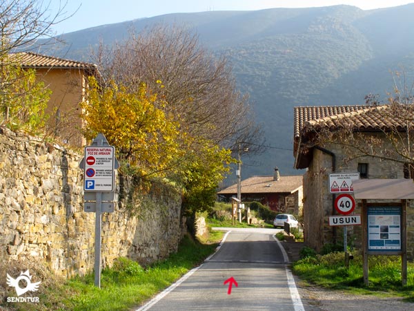
To get to Usún, follow the NA-178 road that links Lumbier with Ochagavía in the Selva de Irati and runs through the Salazar valley. This road starts in the middle of the A-21 dual carriageway, between Pamplona and Jaca, crossing Lumbier and reaching the town of Romanzado where we will find the detour that will take us following a narrow road to Usún. Once there and right at the entrance to the town we will have some improvised earth car parks where we can leave our vehicle.
A perfect route in which we can get our friend accustomed to nature walks, always bearing in mind that we are in a nature reserve visited by many people and in which pets have to be tied up.
The water should not be a problem because the river, facing the valley, is easily accessible and can drink without major complications, although it is important to take into account the time we are going to be in the gorge if we have to bring some food.
As we said before, we are in a nature reserve with certain rules for everyone. We will also meet the horses from the horse-riding school we pass by. And it is not surprising to find the dogs that live in Usun, and although most are tied, we will surely come across one that is not.
We begin the route of La Canaleta next to the car park at the entrance to the town of Usún (0h 00min).

We crossed the town following the course of the road that brought us to it.

In a short time we will find a track that descends to our left and where we must continue. This track takes us quickly out of the village away from it with each step.

Soon we find the equestrian enclosure, next to which we pass, where the horses watch us curious as if they were waiting for us to take them out for a ride.

The track leads us without a doubt, leaving behind the equestrian and heading towards the mountains where the Foz of Arbayún is hidden. The undulating and gentle route allows us to contemplate the transit of the mountainous zone from which the river escapes to the plain that extends to our right.

There are not many crosses that we will find and both the marks of the route that we are walking and the same track that we go are responsible for guiding us without problems.

Our track ends with an improvised roundabout formed by vegetation where the less experienced riders will surely turn around to return. The route crosses the wire fence that delimits the enclosure, thanks to a pair of gates fitted out for this purpose, one large and clearly visible and the other to the right, smaller and more difficult to see until you are not on top of it.

As soon as you cross, the route turns sharply to the right, bordering the fence for a few metres and heading towards the nearby bifurcation that awaits us.

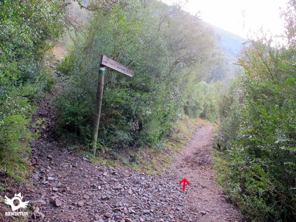
An informative poster marks this bifurcation where we are presented with two options well explained by the post that marks them. The first, recommended for horses, cyclists and hikers less accustomed to decomposed trails, sends us to the right.

If we follow it we will draw a curve trying to alleviate the slope that we have to descend, in exchange we will have to walk a few meters more.

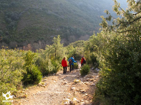
The second indicated for hikers and mountaineers falls down the slope following a cobbled trail with hardly any difficulty but somewhat steeper than the other option.

This trail also meanders along the hillside but without lengthening its paths so much and making us lose height more quickly. As we will return by the same place we have the possibility of verifying by ourselves the difference between the two options that here are posed to us.

Both trails join again faster than we thought, allowing us to sense the limits of the gorge we are about to reach. The descent continues with the two possibilities, following the typical footpath that we will have found in more than one hiking route.

A canaleta acts as a bridge, allowing us to cross the Salazar River while alternating our gaze from one side to the other, observing the interior of the Foz of Arbayún (0h 20min) and the quiet flow of the river towards the Lumbier plain. The route continues its course to the other side making us gain some height at the same time that we leave behind the gutter through which we pass.

Almost at the moment we find ourselves with a new crossing where we will leave the trail of the left that ascends by the hillside of the mountain to continue the comfortable course of our route. We continue with the river on our right as we make our way through the vegetation that surrounds us, gradually gaining some height with each step.

It is not strange that we find this area a little muddy, as the proximity of the river we have to add the sombreness of the journey here. A porthole similar to the one passed at the end of the track that brought us from Usún indicates the proximity of the hermitage towards which we are heading.

A few steps further on, in a small clearing prepared to leave the horses, we will take the access to the Hermitage of San Pedro de Usún (0h 30min). Here we should not be confused since the trail on which we are going continues its course leaving aside the access to the hermitage.

From this point we only have to resume the trail and return on our steps to the Foz of Arbayún (0h 40min) and from there undertake the ascent that will bring us back to Usún (1h 05min), where this route ends.
The route can be made quite long, if we wish.
The uniqueness of the foz and its landscape will certainly influence the increase in time spent for this hiking route, as the surrounding environment invites us to enjoy it calmly.
The Foz of Arbayún is a splendid spot all year round, offering us magnificent panoramic views that are seasoned with the characteristics of each period of the year. It is true that winter can complicate our access on certain days, but on the other hand it will show us the wildest face of this impregnable gorge.
It is advisable to wear footwear like hiking shoes that will give us greater grip on the trochera trail and greater comfort on the dirt road that runs the route. We do not have to leave the camera or binoculars that will allow us to get a little closer to the inside of the gorge. The place invites us to spend a good time enjoying it so it is not a bad idea to take some water and food in our rucksack. As far as clothing is concerned, nothing in particular should be highlighted except that, as always, it is preferable not only to adapt it to weather conditions, but also to wear comfortable clothing or specific clothing for this type of terrain. Consult our list of material and equipment for hiking. Read more.
Physical
The short route and the concentration of almost all the slope in an acceptable ramp, make this route a pleasant walk in which we will not have too many physical demands. In addition we have the possibility in the ascent to continue by the footpath that the horses follow and that in exchange of a few tens of meters more it lowers a few degrees the difference of level of its ramp.
Severity of the environment
The route travels largely by a wide dirt track in which the only dangers are the horses and tractors that we will find. The descent down the mountain trail to the gorge is made through a cobbled terrain in which we will have to take the access to the bridge calmly, because although the typical steps that facilitate the descent have been formed, the floor is slippery especially if it has rained. For the rest and as long as we do not leave the path should not have major complications, always without forgetting that we are in the middle of nature and in a changing terrain. Of course, in the middle of winter, with snow or ice, the conditions of the route increase the difficulty of the same and the material that we will necessarily have to carry to progress safely. Mud and wet roots are other factors that in certain sections of the path, especially from the gorge to the hermitage, will force us to be attentive to avoid slips.
Orientation
Well signposted at the few junctions we will pass, clearly marked the trail to follow, the greatest doubts can surely arise when we reach the end of the road and cross the fence, as there are several paths that seem to leave that point, while our tour to follow a few meters next to the fence, where after a few steps we will see the marks again. Also in the other trails we will find marks indicating the error of course. When arriving at the hermitage the marked path continues straight, it is better to turn around in the hermitage, since if we follow the path we will find a new track and we will be forced to wade the river to be able to return to Usún or to turn around returning on our steps.
| 1-Usún | 0:00h | 489m | 0Km | 30T 645789 4725285 |
| 2-Foz of Arbayún | 0:20h | 460m | 1.3Km | 30T 646667 4724705 |
| 3-Hermitage of San Pedro of Usún | 0:30h | 462m | 1.8Km | 30T 646316 4724512 |
| 4-Foz of Arbayún | 0:40h | 460m | 2.3Km | 30T 646667 4724705 |
| 5-Usún | 1:05h | 489m | 3.6Km | 30T 645789 4725285 |
Coordinates UTM Datúm WGS84

![]() Slope: 224m
Slope: 224m
![]() Slope +: 112m
Slope +: 112m
![]() Slope -: 112m
Slope -: 112m
![]() Maximum altitude: 505m
Maximum altitude: 505m
![]() Minimum altitude: 460m
Minimum altitude: 460m

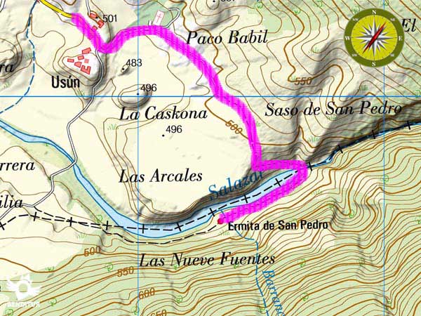
This sketch of the route is not made to scale nor does it contain all the information relating to the area, it is merely indicative.

This schematic with the path is approximate and has been created from the derived cartographic base © Instituto Geográfico Nacional "Cuadrante 174-2 1:25.000"
Senditur has manipulated the tracks to correct the aberrant points that may exist, caused by problems with the reception of the GPS signal. In any case the tracks are always approximate. SENDITUR encourages you to use the new technologies within your reach, using them as support and consultation in your activity, not basing the realization and orientation of the same only and exclusively on them, since they may see their functioning altered by very diverse causes, not functioning correctly and their indications may not be precise.
Find out what to see in...
¿Did you know that...
Until relatively recently there was the custom by the neighbors of nearby towns in periods of drought to go in prayer to the hermitage of San Pedro and after listening to mass portar with the image of the saint to the bank of the river with the intention of throwing it into the water on several occasions. It is said that in a few days it began to rain.
Don't miss out...
The Iso viewpoint, also known as the Foz of Arbayún viewpoint, a spectacular balcony suspended in the air from which you can bird's eye view of the Foz and the Salazar River at its entrance. From there we will surely be able to observe the vultures or the peregrine falcons among others.
From the commitment of SENDITUR with Nature and the respect to the balance of the environment, SENDITUR urges you to travel in a responsible way, with low environmental impact and respecting at all times the Natural, Cultural and Social environment wherever you go.
Besides sharing with all of us your experience on the route we would be grateful if you could write to us to inform us of any erroneous or outdated information you may have found, or simply to let us know what you think at Thank you.
This route has been carried out in the field by SENDITUR on 15-05-2016. The route may vary greatly depending on the time of year, weather conditions and terrain, as well as the actions of third parties and the evolution suffered in the natural environment where it is located. All opinions, advice and/or assessments made by SENDITUR in their descriptions are for guidance only and are subject to and/or refer to the specific conditions of the specific day of the route, referring to that specific day, taken from trained people, with the appropriate experience and with a high level of physical and technical preparation as a reference, as well as correctly equipped.
All the times are approximate and take an orientative character, the stops have not been taken into account, no matter how small they are. All the information related to the route, texts, images, videos, maps, diagrams, tracks, towns, and places of tourist interest are published as a guide, and may not coincide with the current state of each place. Before undertaking any activity, assess your technical knowledge, your physical condition, find out about the weather and the variations that the route may undergo, equip yourself correctly, be prudent and responsible at all times, and do not exceed your capabilities. SENDITUR is not responsible for any misuse or inappropriate use of the comprehensive guides of its routes and/or publications as well as its electronic guides, nor for any variations in their descriptions for the aforementioned reasons, and recommends that everyone be responsible and prudent in carrying out the activity. We also encourage you to read books and specialised guides to complement the information described above.
Continue watching …