Welcome to SENDITUR.COM · paths · routes · tourism

![]() Difficulty-Adapted
Difficulty-Adapted
![]() 1:30 h.
1:30 h.
![]() 6.5 km.
6.5 km.
![]() Difficulty-Adapted
Difficulty-Adapted
![]() 1:30 h.
1:30 h.
![]() 6.5 km.
6.5 km.
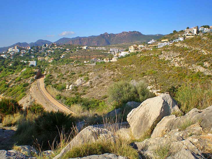
Fine sandy beaches and prestigious tourist towns are just some of the attractions of the Costa de Azahar, in the province of Castellón. A stretch of Mediterranean coastline that also conserves, although it may not seem like it, a great scenic beauty and environmental value, with cliffs and natural spots that are well worth visiting. The old railway line that used to run along the coast was moved inland to make room for today's modern trains, leaving the old route in disuse. This route, specifically the section between the towns of Benicássim and Oropesa del Mar-Orpesa, has been converted into the beautiful Greenway of the Sea, a route of just 6 km, ideal for the whole family, on foot or by bicycle, and even adapted for people with reduced mobility. A walk that allows us to immerse ourselves in the history and landscapes that this area of Castellón treasures.
As we already know, this route links the towns of Oropesa and Benicássim, following the old railway line that used to cross the coast. Therefore, we can start the Greenway of the Sea in either of the two towns, depending on where we are. There is also a public transport service that connects them, in case we don't want to make the return journey for whatever reason.
The starting point of the Greenway of the Sea in Benicásim is at the end of Barcelona Avenue, just where it meets Voramar beach. There we will see the old railway bridge and just after passing under it we will come across the cycle lane that runs along the greenway, a cycle lane that extends for even more kilometres towards the interior of the town. We can continue along the street that starts on the other side of the bridge, leaving the avenue Barcelona, and which runs almost parallel to the greenway, as a little further on we will have another access point to the route and a parking area.
In Oropesa del Mar the route of the Greenway of the Sea begins halfway along the promenade of La Concha beach. In fact, it is on this promenade where, as well as being able to park our vehicle, we will find the signpost that indicates the street that leads us to the nearby route of the greenway, which is located behind the buildings that mark out the promenade. Just after crossing these buildings and before reaching the new railway line, we will find the beginning of the route.
The promenade of La Concha beach in Oropesa (0h 00min) marks the starting point of this beautiful route. We leave the buildings behind to go in search of the true beginning of the Greenway of the Sea. You will recognise the exact point not only by the signposting, but also by the welcoming rest area at the spot. This first part of the route runs parallel to the new railway line that replaced the one we are now enjoying. On our way we will cross a bridge or two as we leave Oropesa del Mar behind us. Mount Bovalar stands in our way, giving us two options, the first is to follow the route of the greenway that goes into the tunnel that crosses the mountain. The second option is to go around it following the paths that connect the north mouth with the south mouth of the tunnel, an option that we can take on our return.
After reaching the other side, the Barranc de la Donay, a beautiful area of cliffs, awaits us.
After crossing one of the typical railway trenches, the Corda Tower awaits us, which reminds us of the fascinating history of this region. We follow the route of the Greenway of the Sea, leaving for later the countless paths that lead us to the crystal clear waters of the sea that bathe the beach of La Renegá. We continue our route until we reach the trench that cuts through the hill where the Tower of Colomera sits. This is a place where we can also enjoy a spectacular viewpoint on the edge of the cliff. We say goodbye to this spot to walk the last stretch that separates us from Benicássim (1h 30min), where Les Platgetes awaits us, just before reaching the town and ending the route or where we will begin the return itinerary.

Vía Verde del Mar-CC/SkyMaja
Vía Verde del Mar-CC/SkyMaja

Vía Verde del Mar-CC/Bronstein

Vía Verde del Mar-CC/SkyMaja
1-The greenway is suitable for both pedestrians and cyclists, in fact it has differentiated zones to avoid mishaps.
2-The route has hardly any slope and is laid out with asphalted and pressed gravel sections, so that it is possible to go with pushchairs or wheelchairs.
3-The tunnel is approximately 600 m long and is equipped with artificial light.
4-Make the most of the rest areas and the different paths that lead to the sea to make the most of the route.
 |
 |
 |
 |
 |
| 1-Oropesa del Mar | 0:00h | 15m | 0km | 31T 255906 4440910 |
| 2-Benicássim | 1:30h | 15m | 6.2Km | 31T 251622 4438133 |
Coordinates UTM Datúm WGS84

.png) Distance: 6.5Km
Distance: 6.5Km
.png) Time: 1:30h
Time: 1:30h
.png) Difficulty: Adapted
Difficulty: Adapted
 Slope: 20m
 Slope +: 15m
 Slope -: 5m
 Maximum altitude: 22m
 Minimum altitude: 10m

![]()
This schematic with the path is approximate and has been created from the derived cartographic base © Instituto Geográfico Nacional "Cuadrante 616-4 1:25.000".

¿Did you know that...
At the end of La Concha beach, in Oropesa, at the top of a promontory are the remains of an ancient Iberian settlement dating from the Stone Age, which was one of the first human settlements in Orpesa la Vella.
Don't miss out...
The Oropesa viewpoint you will find at the top of Mount Bovalar. You can get there by following one of the paths that start from the greenway, around the tunnel that crosses the mountain.


From the commitment of SENDITUR with Nature and the respect to the balance of the environment, SENDITUR urges you to travel in a responsible way, with low environmental impact and respecting at all times the Natural, Cultural and Social environment wherever you go.

Besides sharing with all of us your experience on the route we would be grateful if you could write to us to inform us of any erroneous or outdated information you may have found, or simply to let us know what you think at Thank you.
Route information updated on 20-11-2020. The route may vary greatly depending on the time of year, weather conditions and terrain, as well as the actions of third parties and the evolution suffered in the natural environment where it is located. All opinions, advice and/or assessments made by SENDITUR in their descriptions are for guidance only and are subject to and/or refer to the specific conditions of the specific day of the route, referring to that specific day, taken from trained people, with the appropriate experience and with a high level of physical and technical preparation as a reference, as well as correctly equipped.
All the times are approximate and take an orientative character, the stops have not been taken into account, no matter how small they are. All the information related to the route, texts, images, videos, maps, diagrams, tracks, towns, and places of tourist interest are published as a guide, and may not coincide with the current state of each place. Before undertaking any activity, assess your technical knowledge, your physical condition, find out about the weather and the variations that the route may undergo, equip yourself correctly, be prudent and responsible at all times, and do not exceed your capabilities. SENDITUR is not responsible for any misuse or inappropriate use of the comprehensive guides of its routes and/or publications as well as its electronic guides, nor for any variations in their descriptions for the aforementioned reasons, and recommends that everyone be responsible and prudent in carrying out the activity. We also encourage you to read books and specialised guides to complement the information described above.
Continue watching …


