Welcome to SENDITUR.COM · paths · routes · tourism


Hermitage of San Frutos
Carrascal del Río, Segovia![]()
![]()
![]()
![]()
![]() (1)
(1)
A landscape of great beauty and considerable archaeological and historical wealth
![]() Difficulty-Low
Difficulty-Low
![]() 0:45 h.
0:45 h.
![]() 2.4 km.
2.4 km.
Carrascal del Río, Segovia![]()
![]()
![]()
![]()
![]() (1)
(1)
A landscape of great beauty and considerable archaeological and historical wealth
![]() Difficulty-Low
Difficulty-Low
![]() 0:45 h.
0:45 h.
![]() 2.4 km.
2.4 km.
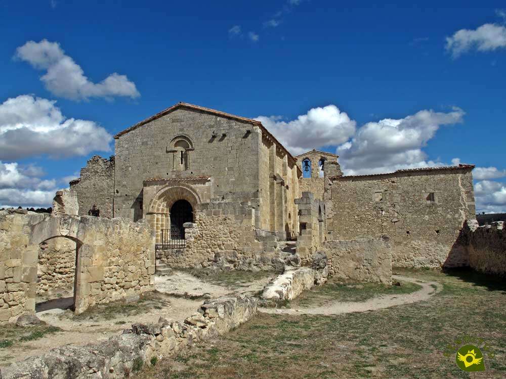
The Natural Park of the Hoces of the Duraton River, in Segovia, extends around the winding and beautiful landscape that the waters have formed after passing through Sepulveda. It is a place where you can walk among colossal cliffs that not only contain the great natural value of its landscapes. It also has an important historical and archaeological heritage, as well as being home to numerous animal and plant species, as is the case with the Hermitage of San Frutos.

The route, with its 2.4 km, allows us to get close to one of the most beautiful corners of this Natural Park of the Hoces of the Duraton River. From where it leaves the route, in the zone qualified like parking when finalizing the track that arrives from Villaseca, nothing makes us intuit the magnificent spectacle with which the nature is going to give to us later. A wide path takes us into the surroundings of the old priory of San Frutos. The vegetation that surrounds us speaks to us of the extreme conditions here, with cold winters and hot summers, while in front of us we begin to sense the wild landscape that awaits us. A landscape that we can contemplate in all its splendour from the viewpoint of the Hermitage of San Frutos, to which we deviate for a moment, and from which we will undoubtedly have trouble saying goodbye to continue with the journey.

The Duratón River, the meanders it draws and the imposing rocky cliffs that surround it are flown over by countless griffon vultures that undoubtedly do not miss any detail of what we do in their home. Little by little we are approaching the doors of the hermitage of San Frutos, patron saint of Segovia, not without first crossing the small bridge that bridges the gap known as La Cuchillada. The remains of the old priory are spread out in this moorland giving us, together with the necropolis that sits here, a welcome to this privileged spot. Inside, the 12th-century Hermitage of San Frutos awaits us, and behind it there is a wide esplanade that leads to the nearby Priory Cemetery, on the very edge of the land marked by the River Duratón. It is an interesting excursion that, while we return to the parking lot from which we left, encourages us to remember in all its splendor the beautiful landscapes that shape the Natural Park of the Hoces of the Duraton River and that surround this unique Hermitage of San Frutos.

Legend has it that many years ago, when San Frutos still lived here, the inhabitants of the region came to the priory fleeing from the Saracen hordes that were devastating the region. The saint welcomed all of them who, fearful, warned him of the invaders' advance and their prompt arrival to the place. The next morning and after meditating all night, Saint Frutos went to the limits of the priory, where the Saracen generals were already waiting, and urged him to surrender. San Frutos responded by hitting the ground three times with his stick, and the stick began to open up to the Saracens' stupor, creating a huge crack between them and the priory where the locals were taking refuge, saving them from danger and forcing the Saracen hordes to flee in panic. This crack is now known as La Cuchillada and is crossed before entering it.
To access the car park from where the route to the hermitage of San Frutos starts, we must go to the town of Villaseca, which we will find on the SG-V-2418 road. This local road can be accessed from two points, the first is on the road between Sepulveda and Cantalejo, being more or less halfway between these two locations where we will find the junction that leads to Villaseca. Or following the SG-241 road that joins Sepulveda with Peñafiel, shortly after leaving Sepulveda we will reach the junction with the Castrillo de Sepulveda road, being in this town where the detour that leads to Villaseca is located. Once in Villaseca, on the same road, next to the Romanesque church of Santo Tomás, the dirt road that we must follow starts. This path will take us to the parking area where we can park our vehicle to visit the hermitage of San Frutos.
A pleasant walk in which, in addition to complying with the park's regulations, it is not a bad idea, whether they force you or not, to have your dog tied up to avoid disturbing the local fauna, as well as preventing it from falling if it gets too close to the cuts.
The short route does not seem to indicate the need to bring him water, but in summer the heat is tight and the start of the route is far from water points where our friend can drink.
Initially, all the fauna we will meet will be on our heads, but we must take into account that during the breeding periods we may be forbidden to pass through certain places in the park.
 Distance. 2.4Km
Our tour of the interior of the hermitage will increase this figure.
 Time. 0:45h
No doubt this figure will be greatly increased thanks in part to the time we will spend contemplating the magnificent natural site we are in.
 Time of year
Obviously, depending on the moment chosen to visit this natural spot, we will find different conditions that will make the different natural values that surround it stand out more or stand out more. The level of the reservoir or the activity of the fauna that lives here, will undoubtedly condition the final impression that we take of this place, by providing part of its charm.
 Required equipment
The access to the San Frutos hermitage is done by a path in quite good condition so initially with comfortable shoes, if possible sports shoes, should be enough, even more so when it is not very advisable to leave the marked route. The camera and or binoculars for the lovers of the observation of the birds cannot be absent in this stroll either. Consult our list of material and equipment for hiking. Read more.
 Difficulty. Low
Physical
Although we are not facing a demanding route, on our return to the car park from where we started, we will have to face a demanding ramp that can make it difficult for people who are not used to walking or have some physical difficulty. A ramp that, if we take it patiently enough, we will surely be able to overcome without complications, but not without effort.
Severity of the environment
As long as we do not abandon the marked path and respect the recommendations that we will find, we should not have any greater complications than some untimely slip caused by the gravel of the road and its slope. We should not forget that on both sides we have a few cliffs that plunge a few tens of meters into the river, preceded by slippery slopes of loose gravel.
Orientation
The wide path, the corresponding signs and the almost non-existent presence of possible detours, at least initially visible, leave no room for doubt as to the direction to be taken. Even so, if we look closely, we will see the presence of numerous trails that run along the slopes that border the hoces, all of them unmarked and not at all advisable, if we do not know the terrain we are walking on.
 |
 |
 |
 |
 |
| 1-Parking | 0:00h | 1022m | 0Km | 30T 427274 4575408 |
| 2-Viewpoint Hermitage of San Frutos | 0:05h | 984m | 0.4Km | 30T 426916 4575399 |
| 3-Hermitage of San Frutos | 0:20h | 956m | 1.2Km | 30T 426411 4575170 |
| 4-Parking | 0:45h | 1022m | 2.4Km | 30T 427274 4575408 |
Coordinates UTM Datum WGS84

 Slope: 232m
 Slope +: 116m
 Slope -: 116m
 Maximum altitude: 1022m
 Minimum altitude: 945m

This sketch of the route is not made to scale nor does it contain all the information relating to the area, it is merely indicative.

![]()
This schematic with the path is approximate and has been created from the derived cartographic base © Instituto Geográfico Nacional "Cuadrante 430-2, 1:25.000"
Senditur has manipulated the tracks to correct the aberrant points that may exist, caused by problems with the reception of the GPS signal. In any case the tracks are always approximate. SENDITUR encourages you to use the new technologies within your reach, using them as support and consultation in your activity, not basing the realization and orientation of the same only and exclusively on them, since they may see their functioning altered by very diverse causes, not functioning correctly and their indications may not be precise.


Precioso, sin lugar a dudas uno de los lugares que visitar en la zona de Sepúlveda, además de ser un paseo sencillo…

Special Protection Area for Birds, integrated in the Natura 2000 Network


Find out what to see in...
¿Did you know that...
The winding stretch of the Hoces of the Duraton River between the towns of Sepulveda and Burgomillodo is approximately 27 km long and is surrounded by vertical rock walls that in some areas reach an altitude of just over 100 m. These walls are home to different species of both animals and plants that have adapted to this rugged terrain, for example a striking rock plant known as the Zapatitos of the Virgin.
Don't miss out...
The Cave of the Seven Altars that you will find near the Villaseca Bridge, a bridge that crosses the road that leads to Villaseca and where you will find a small parking area from where the path that leads to Sepulveda starts. The path passes next to the cave a few metres away, which can be reached by a steep trail equipped with stairs and a railing.


From the commitment of SENDITUR with Nature and the respect to the balance of the environment, SENDITUR urges you to travel in a responsible way, with low environmental impact and respecting at all times the Natural, Cultural and Social environment wherever you go.

Besides sharing with all of us your experience on the route we would be grateful if you could write to us to inform us of any erroneous or outdated information you may have found, or simply to let us know what you think at Thank you.
This route has been carried out in the field by SENDITUR on 16-09-2017. The route may vary greatly depending on the time of year, weather conditions and terrain, as well as the actions of third parties and the evolution suffered in the natural environment where it is located. All opinions, advice and/or assessments made by SENDITUR in their descriptions are for guidance only and are subject to and/or refer to the specific conditions of the specific day of the route, referring to that specific day, taken from trained people, with the appropriate experience and with a high level of physical and technical preparation as a reference, as well as correctly equipped.
All the times are approximate and take an orientative character, the stops have not been taken into account, no matter how small they are. All the information related to the route, texts, images, videos, maps, diagrams, tracks, towns, and places of tourist interest are published as a guide, and may not coincide with the current state of each place. Before undertaking any activity, assess your technical knowledge, your physical condition, find out about the weather and the variations that the route may undergo, equip yourself correctly, be prudent and responsible at all times, and do not exceed your capabilities. SENDITUR is not responsible for any misuse or inappropriate use of the comprehensive guides of its routes and/or publications as well as its electronic guides, nor for any variations in their descriptions for the aforementioned reasons, and recommends that everyone be responsible and prudent in carrying out the activity. We also encourage you to read books and specialised guides to complement the information described above.
Continue watching …


