Welcome to SENDITUR.COM · paths · routes · tourism

![]() Difficulty-Moderate
Difficulty-Moderate
![]() 4:05 h.
4:05 h.
![]() 12.2 km.
12.2 km.
![]() Difficulty-Moderate
Difficulty-Moderate
![]() 4:05 h.
4:05 h.
![]() 12.2 km.
12.2 km.
![]()
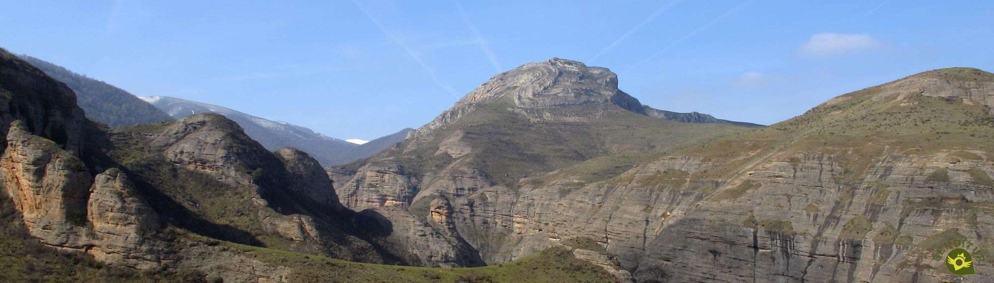
At the foot of the Sierra of La Demanda, along the border that separates this Sierra of La Demanda from the Najerilla Valley that flows into the nearby and wide valley of the Ebro, we find the Route of Saint Quiles. This hiking route in La Rioja goes up from the town of Matute to the summit of Saint Quirico following the route of the traditional pilgrimage that the inhabitants of Matute make every year, carrying the figure of the small Saint, to the summit of the mountain where the hermitage of Saint Quiles is located.

The route of Saint Quiles with 12.2 km leaves from Matute, where we will be able to visit its church of Saint Roman or to cross its streets to discover its flamboyant Indian houses or the shields that carry some of the buildings with more history of the locality. The imposing rocks under which Matute is located are the habitat chosen by countless animal species such as the common vulture, the eagle owl or the peregrine falcon. The Route of Saint Quiles will transport us in its first part through this place of great natural value, where it coincides with the Path of the Jump of the Water that enters even more in these shaded ravines. Our route, on the other hand, ascends the side of the mountain allowing us to enjoy, in exchange for the extra effort, magnificent panoramic views of the valley and the mountains. The route takes us to places such as Londeperro, a green meadow where we can recover our strength to face a new ascent to the limits of the sheepfold that marks the entrance to the beech forest we will enter. It is at this point that we must say goodbye to another of the routes that have accompanied us up to this point: the Route of Three Towns, which continues its course towards Anguiano. The leafy beech forest surrounds us in this part of the route in which the slope becomes a little more remarkable, while we snake among the trees on the side of the mountain.

If we are attentive and the leaf litter allows it, we can discover the Las Canales spring, which flows practically at ground level, shortly before leaving the beech forest we are walking through. A short break in the luxuriant vegetation of the route will allow us to contemplate the path travelled and the magnitude of the height gained. Once again, inside the forest, the route will continue to demand a considerable effort from us in order to bridge the gap that still separates us from the summit. The trees gradually give way to a cobbled path that climbs up the shoulder of the mountain to the same meadow that houses the hermitage of Saint Quiles and the summit of the mountain. Once the pilgrimage to the chapel of the patron saint of Matute is over, we will have to decide whether to return by the same place or on the contrary, set a course for the Cervanco Pass, where the point awaits us and followed by this Route of Saint Quiles. Those who dare to follow will be able to contemplate, on the one hand, the mountain range that extends from Peñalba towards the Najerilla valley and, on the other hand, the town of Anguiano at the bottom of the valley. Cervanco Pass offers the possibility of linking this Route of Saint Quiles with the Route of Three Villas and even with the Route of Valvanera, thus extending not only the mileage but also the beauty that this route already has.

Legend has it that many years ago, when the images of Santa Julita and San Quirico remained in the chapel at the top of San Quiles, a nobleman who knew how miraculous little San Quirico is for fevers, brought him down to his house in the valley to pray for his daughter who was ill. She was healed and the nobleman, happy to see his daughter healed, decided to leave the Saint in the village church, not returning the little Quirico to his mother. Time passed and a series of thunderous and devastating storms hit the village incessantly. The villagers, terrified by the virulence of these storms, agreed to take the figure of San Quirico on a pilgrimage to the chapel to visit his mother, and the storms ceased. The pilgrimage was repeated year after year so that Quirico could be reunited with his mother Julita.
Access to the village of Matute, 16 km from Nájera, is along the local road LR-432 from Bobadilla to Tobía. Following the LR-113 that joins the towns of Nájera and Salas de los Infantes we will arrive at Bobadilla, where the detour that leads us to Matute is located. The unmistakable silhouette of the Rocks of Matute and Tobía serves as a reference. Once we have taken the detour, travelling part of the Route of the Monasteries, we will have to leave this road to turn, heading towards these rocks where Matute is located at its base. The daily bus service, which connects the towns of the region with Nájera, also stops in Matute. Once there, we only have to go into the town following the street that connects it to the road. This street takes us directly to the church square where we can leave our vehicle.
This is a demanding route due to its unevenness, which is mainly developed through paths and meadows. It is advisable not to give it too much margin to avoid unnecessary efforts and even possible mishaps.
A priori we will only have water points at the beginning of the route so it is advisable to take some extra food and water.
This trekking route goes through an area of special ecological value, a habitat chosen by different species of birds and mammals, not being rare to find them. The cattle, although in less quantity, is also a habitual one of the sheepfolds. At the beginning of the route it is also not unusual to come across the dogs that live in this area.
The square of the church of San Román, in Matute (0h 00min), is the starting point of this climb to Saint Quiles.

We follow the course of the Main Street leaving behind the church and the information signs of the itineraries that we have available. In this part of the itinerary, the Route of Saint Quiles, the Path of the Jump of the Water and the Route of Three Villas coincide.

We quickly leave the main street to begin the ascent that will take us out of Matute following the marks, which in duplicate, indicate the itinerary.

With no more detours, Orive Street is in charge of guiding us through the town. The houses are giving way and soon we will be surprised by the abrupt landscape ahead of us.

We left Matute behind to continue our gentle ascent, now along a wide dirt track that takes us past a cattle fence.

Shortly after leaving this fence, in the middle of the curve, we leave the track we are on to start a fast descent that makes us lose the height gained.

The path we descend gives way to a conditioned trail with steps that takes us to the bottom of the valley.

At the end of this area of stairs the route continues up the ravine following the course marked by a small irrigation ditch. The Rigüelo stream accompanies us for a few metres while we go into the colossal rocks that rise above our heads.

We crossed a wooden gate and shortly afterwards we crossed the creek and walked the last few meters where we coincided with the stream.

As soon as we get out to a small clearing, our tour turns around, saying goodbye to the Path of the Jump of the Water, to begin the real ascent to Saint Quiles. A craggy footpath leads us quickly to a wide sheepfold.

As soon as we arrive, on our right we see the poles that force us to climb up the meadow to take the shoulder of the mountain.

We continue to gain height quickly while enjoying the spectacular landscape around us.

The trail we are on leads us to some lonely rocks that we saw on the left side of the mountain when we left Matute. We bordered this rock on the left to continue the ascent.

In this part of the route we move forward between the shoulder of the mountain on our right and a metal fence on the left.

The trail, somewhat blurred in some areas, is divided into more than one occasion forcing us to be attentive to the marks of the route to avoid being misled or making unnecessary efforts.

We advance along the hillside, as the fence separates from us with every step. Some lonely holm oaks on the shoulder of the mountain serve us as a reference in case of doubt, since the path continues its upward course leaving them on our right.

The slope, already less demanding, and the slightly more marked path give us a break that allows us to recover the necessary strength for the next hard climb that awaits us.

We arrive at the pass of La Pala, where several paths meet. Here we go up the few meters that separate us from the shoulder of the mountain.

Ahead of us lies a tough and steep stretch where we will continue to gain height. The decomposed trail leads us to a lonely holm oak to skirt a first hill.

Almost at the moment we will have to abandon the marked footpath we are on in order to go to the summit of a second hill and gain the shoulder of the mountain again.

This stretch, full of more or less marked trails, continues to make us gain height not without effort. Once we have overcome this stony obstacle, the route continues to take us to a large sheepfold.

In front of us we can already see the line of trees that mark the entrance to the beech forest (1h 00min) and the point where the Route of Saint Quiles and the Route of Three Villas say goodbye. At the Londeperro pass, as well as separating the Tres Villas route from ours, it is also the point where the Tres Villas variant arrives. This is a beautiful route that starts at La Cubilla, thus considerably shortening the original route of Tres Villas and giving us the possibility of returning along it if we continue from the summit of San Quiles to the Cervanco pass, then descend to La Cubilla and return along this variant to this point and then descend towards Matute, thus completing a route of approximately 14 km.

We continue straight on into the beech forest, leaving the path on our left that continues the Route of Three Villas. The landscape changes radically as we enter the leafy beech forest.

The ascent is relentless and continues to make us gain height as we cut through the mountainside.

The trail makes its way through the trees, forcing us to face some hard ramp that, along with the mud, which we are sure to find depending on the season, demands an extra effort from us in order to move forward.

The itinerary winds along the side of the mountain trying to make the slope more bearable to overcome. Our trail leads us again to the outside of the forest making us believe that we are just a few meters from the summit.

Nothing could be further from the truth. After climbing a few more metres and shortly before reaching a solitary tree, the route turns sharply to our right to lead us back into the beech forest.

As we enter the leafy forest, the slope becomes more demanding again and the trail we follow gains height quickly.

The leaf litter almost hides the route to be followed while the trees gradually give way. We approached the limits of the forest and faced a beautiful rocky stretch that led us to the shoulder of the mountain.

The footpath changes direction again to face the final cobblestone stretch of the ascent. Saint Quiles awaits us, but we still have a demanding ascent to make without the protection of the trees.

The long final shoulder leads us to the wide sheepfold that serves as the summit. As soon as we reach it, on our right, we can already contemplate the silhouette of the hermitage of Saint Quirico or Saint Quiles towards which we are heading.

The summit of Saint Quiles (2h 00min) gives us impressive views on clear days.
Once we have enjoyed the surrounding environment, we can continue our walk and return to Matute (1h 15min from here), returning in our footsteps, and make a route of 8.5 km in total. Or extend the route by approaching the Cervanco Pass, the point of union with more routes belonging to the Routes between Beech forests, such as the Route of Three Villas or the Route of Valvanera.

If we decide on this option, the route, taking the door of the chapel as a reference, begins the descent towards W-SW, leaving the trail on the right by which we reached the chapel.

We go through the sheepfold losing height little by little towards the side of the mountain where we will find the cobblestone trail by which we will continue the descent to the Serradal pass.

In this section of the descent we will come across several trails that seem to take us to this pass, each one with its own particular layout.

Once on the pass we have to gain some height again while we continue, this time yes, a more marked trail.

We quickly jumped over the mountain and saw ourselves going down the opposite slope to the one we had been going up so far. The narrow trail goes through an area of bushes and scrub at the same time that it makes us lose height comfortably.

After a while our path comes to an end when it meets a path along which we can continue towards the Cervanco pass if we wish to do so. On the other side a new path awaits us, along which the route markers lead us.

This path descends quickly and leads you without further detours to the pass Cervanco (2h25min). Once here we can return to Matute (4h 05min) and retrace our steps and thus finish the route or follow some of the routes that converge here and that will take us to Tobía and Matute or to Anguiano along the Ruta de Tres Villas or to Valvanera along the route that bears its name.
 Distance. 12.2Km
This figure will change depending on our return itinerary.
 Time. 4:05h
This time corresponds to the complete route, round trip between Matute and Cervanco, if we modify the proposed route the time needed will vary both for and against depending on the route we follow.
 Time of year
If we have good visibility this route offers us the added value of the spectacular landscape that it offers along a large part of the route. Of course, autumn and spring offer their special colouring as an incentive to the beautiful route. On the contrary, the winter, or rather the snow, increases the difficulty of the route, but in exchange it offers us a singular landscape reserved for mountaineers.
 Required equipment
Although it may not seem so, we are facing an ascent to a mountain that is the border between the valley and the mountains so the climate can change quickly. Trekking boots, walking sticks, warm clothes, food and water are companions that cannot be missing in this route of hiking. Protection against the sun, sunglasses, hat, cream... we should not leave it at home either, even if it is winter, when the snow usually makes an appearance forcing us to adapt our equipment to these conditions of the route. Consult our list of material and equipment for hiking. Read more.
 Difficulty. Remarkable
Physical
The slope to be overcome in the relatively short distance in which we must do so is undoubtedly the greatest physical demand we will face, although taking the route calmly enough should not pose any problem to someone used to this type of terrain. The advantage of being able to extend or reduce the total route plays in our favour by allowing us to adapt it to the characteristics of each one.
Severity of the environment
We must not forget that we are in a changing natural environment that we cannot control. Even so, the route does not present greater complications, under normal conditions, than the mud that we can find in some areas of the route, especially in the beech forest. Another area where we must pay attention is in the descent of the chapel towards Cervanco, it runs along the cobblestone hillside of the mountain where we are exposed to slips, especially if we do not follow the right path. Be careful not to get off the track, we are going through a mountainous area with vertical rocks and deep ravines that flank much of the route.
Orientation
At the beginning of the route, the yellow and orange signs of the Routes between Beech Forests coincide with the white and purple ones of the Path of the Water. We also coincide with the itinerary of the Route of Three Villas so we must have clear, the marks and the route to follow. The stretch of the ascent to the entrance of the beech forest where both routes are separated is the one that can give us the most headaches, since there are many footpaths that seem to take the same direction and not following the correct one can make us assume an unnecessary overexertion. Besides, the footpath in this part of the route has areas in which it is not very marked, almost getting blurred in the grass. Another point where it can be difficult to find the correct route is at the beginning of the stretch between the chapel of Saint Quiles and the Cervanco Pass, since until we are almost halfway up the slope we will not see the path we have to follow.
 |
 |
 |
 |
 |
| 1-Matute | 0:00h | 682m | 0Km | 30T 516877 4682920 |
| 2-Entrance to the beech forest | 1:00h | 1005m | 2.6Km | 30T 517185 4680979 |
| 3-Saint Quiles | 2:00h | 1342m | 4.2Km | 30T 517181 4680193 |
| 4-Cervanco Pass | 2:25h | 1225m | 6.1Km | 30T 515718 4679436 |
| 5-Saint Quiles | 3:15h | 1342m | 8Km | 30T 517181 4680193 |
| 6-Entrance to the beech forest | 3:35h | 1005m | 9.6Km | 30T 517185 4680979 |
| 7-Matute | 4:05h | 682m | 12.2Km | 30T 516877 4682920 |
Coordinates UTM Datum WGS84

 Slope: 1900m
 Slope +: 950m
 Slope -: 950m
 Maximum altitude: 1342m
 Minimum altitude: 682m

This sketch of the route is not made to scale nor does it contain all the information relating to the area, it is merely indicative.

![]()
This schematic with the path is approximate and has been created from the derived cartographic base © Instituto Geográfico Nacional "Cuadrante 241-1, 1:25.000"
Senditur has manipulated the tracks to correct the aberrant points that may exist, caused by problems with the reception of the GPS signal. In any case the tracks are always approximate. SENDITUR encourages you to use the new technologies within your reach, using them as support and consultation in your activity, not basing the realization and orientation of the same only and exclusively on them, since they may see their functioning altered by very diverse causes, not functioning correctly and their indications may not be precise.


Ruta exigente pero que una vez que estas arriba merece la pena el esfuerzo

Me ha gustado mucho esta ruta, unas vistas y un recorrido muy bonito.


Cradle of the Castilian and pantheon of the seven Castilian heroes

Location of the Virgin of Valvanera, Patron Saint of La Rioja


¿Did you know that...
Saint Quiles, also known as Quirico or Quirce, was the son of Saint Julita, both of whom lived around 300 A.D. According to the books, they were made prisoners as a consequence of their Christian faith, and upon seeing the martyrdom to which his mother was subjected, little Quirico openly declared his faith, costing him his life as well.
Don't miss out...
Just at the beginning of the final part of the ascent, when we reach the rocky shoulder that precedes the summit, when the path changes course abruptly, we can leave the route for a moment and continue a few metres straight, leaving the path behind. We will soon come to a small rocky outcrop from where we will have magnificent views of the Sierra of La Demanda.


.jpg)

From the commitment of SENDITUR with Nature and the respect to the balance of the environment, SENDITUR urges you to travel in a responsible way, with low environmental impact and respecting at all times the Natural, Cultural and Social environment wherever you go.

Besides sharing with all of us your experience on the route we would be grateful if you could write to us to inform us of any erroneous or outdated information you may have found, or simply to let us know what you think at Thank you.
This route has been carried out in the field by SENDITUR on 10-04-2016. The route may vary greatly depending on the time of year, weather conditions and terrain, as well as the actions of third parties and the evolution suffered in the natural environment where it is located. All opinions, advice and/or assessments made by SENDITUR in their descriptions are for guidance only and are subject to and/or refer to the specific conditions of the specific day of the route, referring to that specific day, taken from trained people, with the appropriate experience and with a high level of physical and technical preparation as a reference, as well as correctly equipped.
All the times are approximate and take an orientative character, the stops have not been taken into account, no matter how small they are. All the information related to the route, texts, images, videos, maps, diagrams, tracks, towns, and places of tourist interest are published as a guide, and may not coincide with the current state of each place. Before undertaking any activity, assess your technical knowledge, your physical condition, find out about the weather and the variations that the route may undergo, equip yourself correctly, be prudent and responsible at all times, and do not exceed your capabilities. SENDITUR is not responsible for any misuse or inappropriate use of the comprehensive guides of its routes and/or publications as well as its electronic guides, nor for any variations in their descriptions for the aforementioned reasons, and recommends that everyone be responsible and prudent in carrying out the activity. We also encourage you to read books and specialised guides to complement the information described above.
Continue watching …


.jpg "Go to Monastery of Valvanera")


