Welcome to SENDITUR.COM · paths · routes · tourism

Stage 04 Pamplona-Iruña-Cirauqui-Zirauki
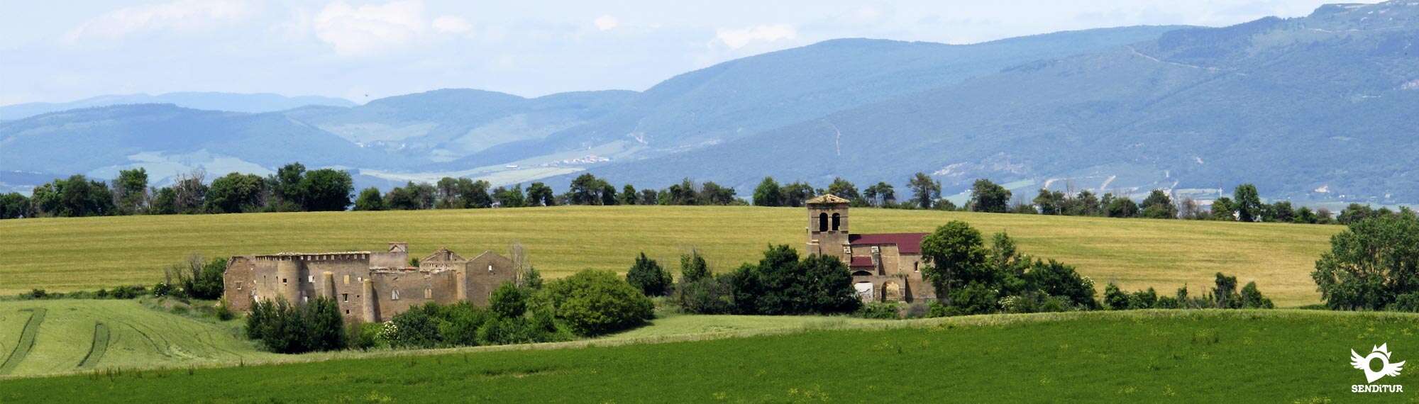
The Alto del Perdón, a natural barrier between the Pamplona and Valdizarbe basins
![]() Difficulty-Remarkable
Difficulty-Remarkable
![]() 7:10 h.
7:10 h.
![]() 31.5 km.
31.5 km.
The Alto del Perdón, a natural barrier between the Pamplona and Valdizarbe basins
![]() Difficulty-Remarkable
Difficulty-Remarkable
![]() 7:10 h.
7:10 h.
![]() 31.5 km.
31.5 km.
From the city of Pamplona-Iruña, passing through the Perdón mountain range, the path leads us to unite definitively and shortly before finishing the stage, in only one, the different variants of the French Way, to leave behind the Arga valley. From now on we will walk accompanying the sun in its usual course from east to west in the direction of Santiago de Compostela. The itinerary from locality to locality runs between the cereal fields, which give way for a moment to the mountain with its undergrowth forest, to its passage through the Sierra del Perdón, to recover the protagonism and only give it up in specific places, full of Jacobean history, where the path passes through the localities that house them.

In the square Consistorial, the façade of the Town Hall, mix baroque and neoclassical that was built in 1752 marks the starting point of this stage 4 Pamplona-Iruña Cirauqui-Zirauki of 31.5 km, which takes us to walk the streets of Pamplona-Iruña with its pleasant parks, such as the Citadel and to immerse ourselves in the campus of the University of Navarra where they grant a special "Compostelana", if before starting the Way of Saint James we have asked them for the necessary credentials to get it at the end of our pilgrimage. From here we say goodbye to the city definitively crossing the bridge of Acella over the river Sadar, heading along a path towards Cizur Menor-Zizur Txiquia observed on one side by the church of San Miguel, ceded to the Order of Malta in 1998, and on the other by the parish of San Emeterio and San Celedonio. Once the locality is past it is time to begin the long ascent to the Alto del Perdón, the cereal fields take over the landscape and we begin to gain height with calm to arrive until a small raft of water and shortly after, to the right of the Way, it is located Guenduláin, old unpopulated lordship of which the remains of the palace and of the church are conserved. The height gained allows us to look back and enjoy the splendid landscape that we are leaving behind us, to reach Zariquiegui-Zarikiegi, from where we begin the final climb to Forgiveness, not before passing by the Fountain of the Reniega, today almost always remains dry. According to a legend, the devil tempted pilgrims with water from this fountain in exchange for denying their faith.

In Alto del Perdón, a natural barrier between the Pamplona and Valdizarbe Basins, we find one of the symbols of the Way, a sculpture that shows a caravan of pilgrims from different periods representing the evolution of the Way throughout its history. It also allows us to enjoy the panoramic view of both sides of the mountain. From here we undertake a dizzying descent that takes us to Uterga, to go quickly to Muruzábal, which highlights its Gothic church of San Esteban XIV-XVII centuries and the Palace of the Marquis of Muruzábal of the seventeenth century, baroque facade, we can also detour to see the peculiar church of Santa María de Eunate. Almost without realizing it we arrive at Obanos historical locality where the French Way and the Aragonese converge in only one. Every summer, a magnificent play called Mystery of Obanos, based on a medieval legend of the Pilgrim's Way to Santiago, is performed in the street in this town. It is worth mentioning the Plaza de los Fueros de Obanos which, together with the church of San Juan Bautista from 1912 and the door of Obanos, make up a beautiful historical complex. From Obanos we walk towards Puente la Reina-Gares, to which we arrive not without greeting the characteristic sculpture of the pilgrim that waits for us at the entrance of the municipality, to cross it by its spectacular main street until the splendid Romanesque bridge of the XI century, on the Arga, built by Doña Mayor wife of the king Sancho III to facilitate the passage to the pilgrims and that gives name to the locality.

But first, this street allows us to contemplate the church of the Crucifix, built by the warrior monks of the Order of the Temple and the churches of Santiago, at the end of the 12th century, and of San Pedro. From now on the Way begins little by little to glimpse the landscape loaded with vineyards that awaits us, going through the district of the nuns crossing practically the convent of the Comendadoras del Espíritu Santo, to advance saying goodbye to the river Arga, towards Mañeru, a beautiful locality with its parish church of San Pedro, neoclassical temple of the end of the XVIII century. In front of us we can already see the slender silhouette of Cirauqui-Zirauki of medieval design and located on a hill and its unique Church of San Román, whose tower allows us to see on the other side. This is where its peculiar town hall square awaits us, where this stage ends and where we arrive after crossing one of the gates of the old wall and crossing the network of steep streets.
The stage is designed, along with the following ones, to reduce by a couple of days the days that are usually proposed in the guides to get to Logroño from Pamplona-Iruña, even so the proximity between the localities allows us to adjust to our characteristics, being able to do the same with the following.
This stage is hard because of its distance, to which we have to add the lack of large shady areas where you can cool down. The greater part of the route goes along a track and dirt tracks, although we will also go along a small section by road.
We will find water points in all the towns through which we pass and some intermediate between them although they are not guaranteed. Although no longer the distance between them, greater in the first half of the route, if not the lack of shade and the force with which the sun punishes these lands, coupled with the strong ramps that we are going to find, makes it essential to have sufficient water reserves and replenish them at each point.
Apart from the usual pets in the villages, the livestock has practically disappeared, although we will pass in the vicinity of the urban centres through agricultural pavilions with their respective guard dogs usually tied up or in their closed enclosures.
The urban layout of the route through Pamplona-Iruña (0h 00min) begins next to the town hall, passing by the nearby church of San Saturnino and its characteristic tower, crossing the long main street that takes us to the park of La Taconera, where we continue straight on along the wide, tree-lined street that borders it.

As soon as we leave this park behind we have to change to the sidewalk on our left that will give us direct access to the park of La Ciudadela.

In this park the marks of the way take us straight to border it by the stroll that surrounds it, we have the possibility of crossing it diagonally by the interior stroll, but this one does not have direct exit to the street by where it follows the way, reason why of following it we will have to be attentive not to jump it.

If we follow the outside promenade a little longer but protected from the sun by the trees through which it runs, we will draw a parabola to the left, crossing the limits of the park until we reach the height of the wide Fuente del Hierro street, where it turns to the right to cross this long street that descends towards the university campus to which we arrive after passing under a viaduct.

The way crosses the park between the buildings of the campus, descending in search of the Sadar river, to when arriving at its height and to deviate to the right, to continue by a wooded zone towards the bridge that to our left crosses it and to say goodbye definitively of the city.

This bridge takes us to the road that leads to the next town of the day, fortunately it is a regular area for walks and the entire route has either a sidewalk or a good andadero that we avoid having to walk on the road.

We continue straight ahead leaving behind us a few accesses to nearby factories, and after passing the bridge over the railway track we reach a crossroads where a pedestrian crossing helps us to cross and continue straight on the sidewalk that ascends towards our objective that is already shown in front of us.

This part of the route without any shade, except for the few trees close to the locality that offer us, becomes something intense due to its constant ascent. Shortly after crossing the highway bridge, we walk through the two churches of the town, one on each side of us, to enter Cizur Menor-Zizur Txiquia (0h 55min).

The road that brought us here is found with a roundabout and the way continues straight down the street that takes us to a small park, next to the sports center, which we cross diagonally to our right and at the end of this continue down the street on our left that finally takes us out of Cizur Menor-Zizur Txiquia.

Walking along this street we can contemplate how at the end of it a dirt road goes straight on and on the horizon Forgiveness awaits us.

This road leads us to a road that marks the urbanized boundary of Cizur Mayor-Zizur Nagusia, following its course we arrive at a crossroads where begins, on the left side of the road, a dirt track that between fields of cereal continues parallel to it taking us out of the population.

The andadero continues close to the road to turn sharply to the left and ascend smoothly between the crops avoiding the long turn that the road draws. This part of the route is practically in constant ascent and there are hardly any shaded areas.

The way is forced to cross a couple of roads to continue leaving behind how many roads it is.

After ascending a small hill, the route begins one of the few descents that it offers us, and soon after we find the only shaded area of the stretch, provided by the trees that gather near a small raft of water.

In this place we have to be attentive because the road we were bringing is with the track, which if we follow it, would lead us to the uninhabited Guenduláin and vegetation hidden at certain times the signs.

Leaving on our right the road that leads to the uninhabited area, we undertake the long and costly ascent that takes us to the vicinity of the next town through which the way passes.

This part of the tour is a slide whose most demanding ramp ends in a small rest area with a couple of benches from where you can contemplate a magnificent view of what has been done so far. From here the road descends again gently to cover the last meters that separates us from Zariquiegui-Zarikiegi (2h 30min), which we arrive passing by its church.

The way continues straight crossing the road that arrives from the near highway of the Way, to cross the main street of the locality and to leave of this one in direction towards our next objective.

The way continues between the more and more absent fields of cereal that are leaving way to the bushes, walking towards the beginning of the ascent that begins turning to the left and leaving the wide way that accompanied us to continue by the path that ascends directly towards the wind mills that mark the top of the mountain.

Leaving behind how many roads we find to the right and left we are ascending gaining height, the main path is becoming a little wider. Shortly before reaching the top of the mountain we leave on our right a path that comes from the nearby motorway, to travel the last meters of the ascent to Alto del Perdón (3h 10min), by the track that reaches it.

Once in the Alto we cross the asphalted track that gives access to the wind farm to begin the fast and strong descent by some stairs that mark the beginning of the same one.

The way, although wide, is in quite bad condition, with a lot of loose stone that together with its initial slope makes us be extremely cautious, although the passage of pilgrims is creating a path that passes close to the trail and can help us, also in some short stretch we find some stairs.

The way crosses a large number of paths that normally return to him, but we must not lose sight of him at any time to avoid confusion.

The descent is smoothed and the path recovers its usual good firm to leave the wooded and scrub area and continue again between fields of cereal.

Continuing along the main road, leaving behind us the paths that lead to our meeting, we arrive at a kind of ravine where we cross a stream to start a short climb to the hill that separates us from the next town.

After this ascent, the path softens again and after passing some agricultural pavilions, you enter Uterga (3h 55min), going straight on along the street that takes you to a nearby park where you will find the road that leads to the town from the dual carriageway.

Cross the town following the road that leads to Muruzábal so that after it turns to the left leave it, leaving it to our right and continue along a street with the cement pavement, a few meters the street comes to an end and the way then turns to the right and finally leaving Uterga.

Shortly after leaving the town, the route turns to the right, leaving the wide dirt track to continue along a path that goes out to meet us.

The way takes us towards the next localityThis way between cereal fields allows us to contemplate our next destiny to which we arrived in a while, finding us again with the road that before we had abandoned and that introduces us definitively in Muruzábal (4h 30min).

We go through the town following the road, leaving on our left the streets that lead to the town and the variant towards Santa María de Eunate, until at the exit of Muruzábal we find a path that on our right continues parallel to the road.

The route, somewhat narrow at the beginning, avoids walking along the road, after passing a tunnel that makes it easier to cross a road with a lot of traffic the route becomes a concrete track with bands of cobblestones, in each band a shell tells us that we are going in the right direction.

Following these characteristic marks in the form of bread crumbs, we go through the streets of Obanos (4h 50min), until we reach the town hall square next to the church.

We leave the square crossing the gate of the old wall to find a road that goes up towards Obanos, on our left we see a street, between the houses, which continues parallel to this road and where the way continues.

Continuing along this street, leaving the road on our left and another street on our right that starts in the same place, we reach the hermitage of San Salvador, where we join our walk the Aragonese Way and the variant that comes from Santa Maria de Eunate.

The road goes straight on saying goodbye to Obanos, approaching at each step the nearby road that accompanies us on our left, until we are forced to cross it to continue now between orchards, and leave it on our right, until we reach the statue of the Pilgrim, which commemorates the union of the Paths.

At this point the route follows the old national route between Logroño and Pamplona-Iruña where, turning left, we must continue a little less than 500 m until we find on our left the first street of the city, which we follow. As soon as you enter it, turn right again and continue straight on along the long street that leads us to Puente la Reina-Gares (5h 25min), through its historic quarter.

The route from the main street takes us to the well-known Romanesque bridge of Puente la Reina-Gares, where we leave the historic centre of the town. When we cross it, turn left and we come across the national road again to follow the asphalted road that passes between the church and the convent of the Comendadoras to start a gentle climb parallel to the road.

When arriving at a crossroads we leave the asphalt track to continue by the dirt road that passes next to the fence of a house whose fronton serves us as a reference, this road embedded between the national one and the river Arga passes through a tunnel that avoids us to cross the road.

The pathway, which we must not abandon at any time, moves away from the dual carriageway, which has changed so much in this area, and after approaching the river change its direction and begin a long, steep climb that takes us to the side of the dual carriageway.

When you reach its height, the slope softens to continue next to it until you reach a roundabout where the path, protected by a wooden railing that marks the path, enters Mañeru (6h 35min), continuing straight on the road becomes a cobblestone street that leads to the town hall square.

Following the street that starts on the left side of the town hall and that quickly turns right to continue straight on the cemetery road, we leave Mañeru and continue parallel to the dual carriageway, although a little further away.

The route continues to leave behind as many roads as it finds and runs between the increasingly common fields of vineyards that are gaining presence to cereal. An initially cobbled path maintains the almost straight course that takes us towards the near end of the stage, passing between the fields and avoiding us to cross the wide curve that the wide dirt road draws and taking us to the entrance of the last locality of the day.

Following the street on the left we arrive at a small wooded area where vehicles are usually parked and where the way turns right and in the next street turn left again, where we find the entrance road to the town and just in front of us the street that ascends towards the historic centre where we arrive at the end of it.

A little to the right we see the door of entrance to him and the steep street that takes us until the square of the city council of Cirauqui-Zirauki (7h 10min), to which we arrive turning to our left at the end of the hard slope.
 Distance. 31,5Km
If our destination is Puente la Reina, the final distance will be less than the distance mentioned here.
 Time. 7:10h
Total non-stop time. If we dare to visit the octagonal churc:of Santa María de Eunate, the detour to it and the subsequent link in Obanos wit:our itinerary is about 3.5 km more, so we must add almost 1:to the total time of the stage.
 Time of year
In spring we will find a spectacular landscape of a varied tonality of greens that form the carpet of the fields where the route passes, to be replaced by the yellow and almost orange tones of the summer, that together wit:the bundles of straw, and the different mountain ranges that in the horizon envelop us, do that we take advantage to the maximum the privileged viewpoints by whic:we pass. In winter and autumn the landscape transforms and on clear days allows us to observe the snow-covered Pyrenean mountains, where we can find the Alto del Perdón nevado.
 Required equipment
Footwear and hiking clothes according to the time of year and weather conditions, equipped backpack, canes, canteen and food. Recommended boots for the ascent, but especially for the descent of Forgiveness, in addition sunglasses, cap and sunscreen that we can not miss, like the camera. Consult our list of material and equipment to make the Way. Read more
 Difficulty. Remarkable
Physical
The greatest difficulty is bot:in the distance of the stage wit:some hard ramp, and in the ascent and cobbled descent of Alto del Perdón. The ascent to Forgiveness starts practically from the surroundings of Cizur Menor-Zizur Txiquia, so as it is long we do not find demanding slopes, whic:give way to even downhill areas that allow us to recover from the effort. We could almost say that the Perdón descent is more intense than its ascent, as it is muc:steeper and together wit:the state of the land, quite decomposed, it means an additional effort for our legs.
Caution
In the first part of the stage we have to pay attention to the numerous street crossings that we are going to find, also up to the first locality of the day we will cross bot:a sidewalk and a small walkway next to the road. We will have to cross the road on several occasions, in addition to circulating a few meters on its hard shoulder at our arrival at Puente la Reina-Gares. Without major difficulties except in the descent of Perdón where, especially if it rains or is muddy, we will have to be careful to avoid slips and falls. In summer the scarcity of shade areas and the hig:temperatures that can be recorded will force us to take the usual precautions, hydration and protection against the sun.
Orientation
Perfectly signposted, it is in the Alto area where the large number of paths created by pilgrims seeking to improve or shorten the journey, can confuse us althoug:we usually find the main pat:again a few meters. The passage throug:the towns is well signposted, even wit:a cobblestone different from the rest in many of them. When we pass throug:the park of La Ciudadela in PamplonaIruña we can cross it diagonally, but this walk has no direct exit to the street where we leave the city and if we shorten it we will have to go expectantly so as not to miss this street.
 |
 |
 |
 |
 |
| 1-Pamplona-Iruña | 0:00h | 445m | 0Km | 30T 610845 4741523 |
| 2-Cizur Menor-Zizur Txiquia | 0:55h | 464m | 4.9Km | 30T 608264 4738106 |
| 3-Zariquiegui-Zarikiegi | 2:30h | 622m | 11Km | 30T 604527 4733645 |
| 4-Alto del Perdón | 3:10h | 764m | 13.3Km | 30T 602913 4732237 |
| 5-Uterga | 3:55h | 493m | 16.8Km | 30T 601588 4729357 |
| 6-Muruzábal | 4:30h | 445m | 19.5Km | 30T 600679 4727118 |
| 7-Obanos | 4:50h | 416m | 21.3Km | 30T 599467 4725947 |
| 8-Puente la Reina-Gares | 5:25h | 348m | 24.1Km | 30T 597052 4725060 |
| 9-Mañeru | 6:35h | 450m | 28.8Km | 30T 593241 4724680 |
| 10-Cirauqui-Zirauki | 7:10h | 492m | 31.5Km | 30T 590854 4725377 |
Coordinates UTM Datum WGS84

 Slope: 1420m
 Slope +: 734m
 Slope -: 686m
 Maximum altitude: 764m
 Minimum altitude: 340m

This sketc:of the route is not made to scale nor does it contain all the information relating to the area, it is merely indicative.

![]()
This schematic wit:the pat:is approximate and has been created from the derived cartographic base © Instituto Geográfico Nacional "Cuadrantes 140 y 141 1:50.000".
Senditur has manipulated the tracks to correct the aberrant points that may exist, caused by problems wit:the reception of the GPS signal. In any case the tracks are always approximate. SENDITUR encourages you to use the new technologies within your reach, using them as support and consultation in your activity, not basing the realization and orientation of the same only and exclusively on them, since they may see their functioning altered by very diverse causes, not functioning correctly and their indications may not be precise.


Yo me quede en Puente la Reina.


At the bottom of a valley near a river and as horizon the sky


Pilgrimage destination in honour of the patron saint of Navarre, Saint Francis Xavier

Find out what to see in...
¿Did you know that...
In the hermitage of San Salvador, in Obanos, all the French variants that reach this place by the Aragonese Way from Somport or by the French Way from Roncesvalles are definitively unified into one.
Don't miss out...
The church of Santa María de Eunate that is in the itinerary of the Aragonese Way and to very little distance of Muruzábal and Obanos. This is one of the most mysterious temples of the Spanish Romanesque and whose name comes from the Basque term that means one hundred doors, was built around the year 1170. Those who dare to visit it from Muruzábal can resume their journey by following the final route of the Aragonese Way that leads to Obanos.


From the commitment of SENDITUR with Nature and the respect to the balance of the environment, SENDITUR urges you to travel in a responsible way, with low environmental impact and respecting at all times the Natural, Cultural and Social environment wherever you go.

Besides sharing with all of us your experience on the route we would be grateful if you could write to us to inform us of any erroneous or outdated information you may have found, or simply to let us know what you think at Thank you.
This route has been carried out in the field by SENDITUR on 14-09-2018. The route may vary greatly depending on the time of year, weather conditions and terrain, as well as the actions of third parties and the evolution suffered in the natural environment where it is located. All opinions, advice and/or assessments made by SENDITUR in their descriptions are for guidance only and are subject to and/or refer to the specific conditions of the specific day of the route, referring to that specific day, taken from trained people, with the appropriate experience and with a high level of physical and technical preparation as a reference, as well as correctly equipped.
All the times are approximate and take an orientative character, the stops have not been taken into account, no matter how small they are. All the information related to the route, texts, images, videos, maps, diagrams, tracks, towns, and places of tourist interest are published as a guide, and may not coincide with the current state of each place. Before undertaking any activity, assess your technical knowledge, your physical condition, find out about the weather and the variations that the route may undergo, equip yourself correctly, be prudent and responsible at all times, and do not exceed your capabilities. SENDITUR is not responsible for any misuse or inappropriate use of the comprehensive guides of its routes and/or publications as well as its electronic guides, nor for any variations in their descriptions for the aforementioned reasons, and recommends that everyone be responsible and prudent in carrying out the activity. We also encourage you to read books and specialised guides to complement the information described above.
Continue watching …


 Previous: Stage 3 Zubiri-Pamplona
 Next: Stage 5 Cirauqui-Los Arcos


