Welcome to SENDITUR.COM · paths · routes · tourism


![]() Difficulty-Remarkable
Difficulty-Remarkable
![]() 7:50 h.
7:50 h.
![]() 34 km.
34 km.
![]() Difficulty-Remarkable
Difficulty-Remarkable
![]() 7:50 h.
7:50 h.
![]() 34 km.
34 km.
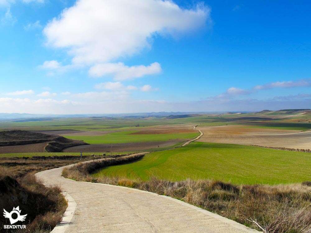
Stage of the French Way of transition that takes us from Hontanas, in the province of Burgos, to Frómista, in the province of Palencia, crossing great plains dotted with some hill that gets in the way of our walk. The Jacobean tradition is clearly reflected in each step we take on this day, from ancient monasteries, chapels and hospitals erected for the service of pilgrims, through the typical localities of the Camino de Santiago that break the undulating landscape that surrounds us in this stage in which we will enter the Tierra de Campos that will accompany us to the ever closer León. The stage 13 Hontanas-Frómista, with 34 Km, that begins in Hontanas, next to the church of the locality, crosses the original layout of the French Way until the Ruins of the Convent of San Antón, old hospital whose rest of the centuries XIV and XV are crossed under its arcade by the road where the Way of Saint James runs.

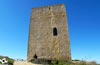
From here a straight itinerary clear of obstacles allows us to observe in detail the remains of a castle on top of a hill. Around it, Castrojeriz, where the ex-collegiate of the Virgin of the Apple tree of the XIII century welcomes us to our arrival to the locality, which we cross with calm, discovering the history and culture that treasures this Celtiberian villa favoured by the first Castilian fuero in the year 974. Passing through the town takes us past the 16th century Santo Domingo church, which houses an interesting museum with beautiful tapestries. The long Plaza Mayor precedes the 13th and 14th century San Juan Bautista church. All this is a small sample of the importance that Castrojeriz has had in the history of Castile, since the town had nine churches and seven pilgrim hospitals. The top of Mostelares, with its imposing slope, shows us in the Viewpoint of Castrojeriz, a spectacular view of the valley, this being the gateway to the vast and undulating plain that lies ahead.

Once descended the high and decided our way between the usual route or the variant of a little more than 1 km that takes us to Itero del Castillo we arrive, from following the usual route, to the Piojo Fountain, where hopefully we can refresh ourselves and enjoy the scarce shade that we find throughout the day. A little further on there is another special corner of the French Way, the Fitero Bridge, where after passing by the gothic Ermita de San Nicolás, from the 13th century we enter, after crossing the Pisuerga, the province of Palencia and the Tierra de Campos, leaving Burgos behind definitively. The leafy poplar grove on the banks of the river leads us to Itero de la Vega, which we reach after contemplating the 13th century La Piedad hermitage. The town hides a worn judicial roll, prelude of which we will find later, and its parish church of San Pedro of the sixteenth and seventeenth centuries, which houses the sepulchre that was bishop of Jaén Antonio de Piña. The Way of Saint James now passes through the natural granary formed by the undulating plains of these lands, our view is lost between fields where some solitary tree breaks with the characteristic landscape. Boadilla del Camino offers us the possibility, deviating a few metres, of contemplating the spectacular jurisdictional roll, one of the best in all Castile and is located next to the parish of the Assumption of the sixteenth and seventeenth centuries.

The tour of the village allows you to discover the typical adobe buildings that are still preserved in so many localities. Before reaching the end of the stage we are surprised by a magnificent work of human engineering that breaks with the monotony of the landscape, the Canal de Castilla, a work carried out between 1751 and 1849 that served for the grain of Castile to leave Santander by means of barges that sailed through it. The passage of the system of locks that control the flow of the canal is the prelude to our arrival in Frómista, a town full of history as attested by the numerous cultural heritage it holds. The hermitage of the Virgen del Otero at a high point at the entrance to the town watches over important places such as the church of San Martín, an 11th century Romanesque work commissioned by Doña Mayor de Castilla, without forgetting the 15th century church of San Pedro or the church of Santa María del Castillo, a sample of the rich history that has accompanied us throughout the period.
If we need it, we can shorten this stage by finishing it in the town of Boadilla del Camino, since the next stage, with few exceptions, is usually finished in Carrión de los Condes, which is only 20 km from Frómista.
Hard stage for the distance and the temperatures that we will be able to find. The terrain is in quite good condition but being almost entirely on dirt tracks, forces us to take extreme care of our friend's legs.
With practically no shade or water points outside the localities, hydration is another important point to take care of in order to avoid heatstroke. Replenish the water we carry even if we still have and carry something more than usual is advisable especially in summer. Beware of falling into the temptation to allow a bath in the channel, its apparent calm should not confuse us, in addition the access is complicated especially to leave.
Except for a few flocks of sheep and the typical fauna of the area will not be very common to find more animals. However, as we pass through the villages we will have the usual encounters with the pets that inhabit them.
The Real street that entered us in Hontanas (0h 00min) has to be the one in charge of taking us out of it.

We begin next to the church of the locality going down this street that after leaving behind some crossing will become the access road to the town.

This one continues with the descent passing next to the municipal swimming pools and arriving at the encounter of the highway that leads towards Castrojeriz. Just at this crossroads, on the other side of the road, we find the dirt road where we have to continue. The track turns left to continue a few metres parallel to the road.

The path turns again leaving the road behind and heading towards a threatening hill where you can see the layout that follows the track to ascend to its top.

Luckily as soon as we begin the ascent we find another track that starts on our left and where we continue, thus avoiding the ramps that were in front of us.

This path with something worse firm places us parallel to the road but farther away from it. The track runs, with a gentle up and down, to the edge of the hillside that we avoided before ascending, to gradually lose width until it becomes a cobbled trail.

This trail fits between brambles and the earth slope that the edge ends in another earth track, which leaves definitively behind the hill that accompanied us.

This new track meets another that comes from the road and, leaving it behind, continues without deviating.

Shortly after leaving this crossroads behind us, the track narrows again, becoming again a trail that will accompany us almost to the road.

Before reaching it, the path turns sharply to the left, heading for the road, which is now wider. Once on the road, the French Way continues along it, without abandoning it until we reach the height of the next town.

This long stretch of narrow road without hard shoulders leads us to the Ruins of the Convent of San Antón (1h 05min), as curiously the road literally crosses the remains of this building.

The route continues leaving to our left Villaquirán de la Puebla and the road that leads towards it, in front of us is already observed our next population although deceptively it seems closer than it really is.

The straight road turns to meet a dirt track that joins it on the right and shortly after we find a cross that marks the beginning of the street where the Way of St. James enters the foothills of the town, leaving the road definitively.

We leave this street to continue along the one that takes us to pass next to the church of Santa María del Manzano.

At the end of the street bordering the church, the French Way turns left again, leaving it behind us, and then turns right again a little later when we come across the first street that comes out in front of us.

We then begin a slight ascent observed by the remains of the castle that watch over us at the top of the hill around which the locality develops. The perfectly conditioned route seems to leave the urbanised area, as the rest of the town is on our left almost hidden by the hill in front of us.

The Way of Saint James meets a small rest area, at which point it turns to the left to skirt the hill of the castle back into the buildings.

The route continues the slight ascent leaving to left and right how many streets and squares it is. The journey through the town is longer than expected to wrap around much of the hill, which hid in the distance, the true extension of Castrojeriz (1h 55min), we reach its main square after a long time of walking the Calle Real.

From its main square, the itinerary continues the straight line that brought us here, beginning a gentle descent that will take us all over the Calle Real, without leaving it at any time.

Passing next to the church of San Juan the route, step by step, takes us out of Castrojeriz, at the end of this long street the route is forced to turn left, showing us the outskirts of the town.

In this place there is a great fountain with a watering place and in front of it the road that we must cross to leave Castrojeriz definitively by the dirt track that starts on the other side of it.

Soon, the path is cut again by another road that we must cross to continue along the wide and comfortable dirt track that leads us to the next challenge of the day.

The wide dirt track leaves to its right and left some path that gives access to the fields that border it, until finding a path that over a stone arch leads us to a wooden bridge that crosses the river Odra or Odrilla.

We continue along this footpath that will make us leave the dirt track for an instant and that will make it easier for us to cross this river, which sometimes cuts the track, and after crossing the bridge we will meet it again.

In front of us it becomes more evident at each step that our route goes towards the strong ramp that for quite some time we had seen drawn on the slope of the hill that stands in our way.

We leave to our right a track and shortly after another one to the left to begin a long and considerable ascent to the High of Mostelares.

This section is advisable to take it with relative calm, dosing well the effort since we still have a long distance ahead. Once we have overcome this difficulty, we will see our effort rewarded with magnificent views of the valley from the Viewpoint of Castrojeriz (3h 05min), added to the extensive plain that extends around us.

The hard climb gives way to a relative calm as the track continues to climb but now almost without realizing it.

We left behind us another crossroads to reach the point where a vertiginous descent begins with even steeper slopes than the one we had to face before to climb to the top.

This descent is fortunately encemented, although it is still very demanding for our battered knees. From the top the Castilian plain extends to the horizon.

After taking the short but steep descent with the calmness needed by the ramps with this slope, we walk again on the comfortable dirt track, which meanders between the cereal fields.

Without deviating from it at any of the crossroads we come across, we arrive at a detour that, if we follow it, would lead us to Itero del Castillo and would suppose us approximately 1 Km more than the original route.

Leaving to the right the track that takes this variant we continue with the soft descent that little by little is approaching us towards the Fountain of the Louse (4h 00min), to which we arrive after crossing us with the tracks that communicate the fields by where the route passes, and to which we have to ignore.

After ascending the hill where this singular fountain is located, surrounded by benches and tables, with luck we will be able to enjoy a rest in the shade of the resistant trees that endure the demanding conditions of these lands.

When arriving at the fountain the French Way leaves to the road of Itero del Castillo to continue the short stretch of ascent that separates us from being able to contemplate this locality.

Once at the top of the hill, there is a straight section of the road until you reach the height of a new dirt track that starts to the left of it.

Leaving the road and following this track, we will soon see the silhouette of the bridge over which we will cross the river Pisuerga, but before we must leave behind another new crossroads and pass next to the Hermitage of San Nicolás.

The Way of Saint James leaves the dirt track to cross the bridge over the Pisuerga and enter a new province, Palencia.

Just at the end of the bridge a small park and some posters inform us of the entrance in this province leaving already the one of Burgos.

As soon as you enter it, the route leaves the road again to continue along a new dirt track that will take you to the next town of the day.

This track, separated from the river by the row of trees that gather on its banks, moves away from them to enter the locality.

Without deviating until you reach a bifurcation of streets where, after following the one on the left, you will find, at that hand, the beginning of another street where you will have to continue leaving the street that, if you go straight ahead, would take you towards the jurisdictional roll that rises close to the town hall.

The itinerary leaves to the left the street that would take us towards the church to continue straight on entering Itero de la Vega (4h 40min).

The route goes straight on without deviating in any of the streets it crosses and almost without noticing it takes us out of Itero de la Vega.

Following the road that gives access to the town we arrive at the nearby road, which we will have to cross to continue along the track that starts on the other side in front of us.

This new dirt track will accompany us the considerable distance that separates us from the next population of the day. This section, by a track in quite good condition and with good width, faces a new climb to another hill that stands in our way.

A much smoother ascent compared to the one at the Castrojeriz exit allows us to enjoy the landscape that we leave behind us until we reach the top of the hill, at which point we can contemplate the path that lies ahead and sense, on clear days, the next locality of the stage.

This ascent, although gentle, becomes tiring if we add up the kilometers covered so far, fortunately soon gives way to a long and pleasant descent.

Step by step we get closer to our next goal, which we reach after passing a leafy rest area.

The entrance to the locality we do it leaving to our right the streets that we are finding, until we are forced to decide between left or right, being this last one the option to take.

As soon as you turn right, you turn left again on the next street that leads to the Plaza Mayor de Boadilla del Camino (6h 30min), the time has come to decide whether to cover the 6 km that separate us from Frómista or to finish today's stage here.

In the square there is a fountain and the town hall building and, on its side, the street where the Way continues.

This street will take us out of Boadilla del Camino, until we reach a crossroads of tracks and streets where the option that follows the straight that brought us here is the one we must choose.

As soon as it starts, the track splits in two, being the one on the left where the itinerary continues. We say goodbye to the town when we find ourselves next to an irrigation canalization and arrive at another crossroads where we turn left, leaving behind us this canalization and the path that follows parallel to it.

Our track is protected from the sun by a pleasant poplar grove that gives us the few moments of shade that we enjoy almost all day today. The track bids farewell to the shadow, heading towards the Canal de Castilla, which awaits us a little further on.

When we reach its height, the path forks and must continue along the slope that crosses the canal and leaves on the left the track that serves as a passage for the crops that border it.

The route next to the course of the channel is made by a track with good firm and with good width that allows us to walk with comfort and to contemplate with calm the corners that this part of the route offers us.

The wooded areas that border the Canal de Castilla offer us, next to it, a pleasant freshness that helps us to carry out the last kilometres of this stage.

When arriving at the height of the locks a small footbridge above them serves us to cross to the other side and to save us this way the descent until the near road.

Just past, on the right, we see a path that descends a short stretch in search of an asphalt track that rises from the road, following the descent by it we go out to the road, where we already receive the first buildings of Frómista.

This street takes us past a crossroads and soon after an underpass that crosses the railway track. Continuing along this long street that follows the layout of the road, we reach Frómista (7h 50min), where this stage ends.

 Distance. 34Km
Etapa larga que podemos acortar cambiando nuestro punto final.
 Time. 7:50h
It is the time that took us to cross this stage, if we decide to deviate for the variant of Itero del Castillo we will have to add to this approximately 20min more that is what it will take us to realize the added distance that has this variant.
 Time of year
Spring and autumn are the ideal seasons where, as a general rule, we will not encounter the extreme conditions that winter and summer demand of the pilgrims who cross these lands. On the contrary the green icy fields of the winter and the intense yellow of the summer make these periods have their particular charm. Be careful wit:the hig:temperatures of summer, it is a stage wit:hardly any shadows and wit:long journeys between towns. Also in times of drought the aquifers are not usually very drinkable.
 Required equipment
Footwear and sports clothes according to the time of the year and to the meteorology, the terrain allows us a footwear something more comfortable according to the meteorological conditions that we are. In the backpack we can not miss the canteen wit:water, sunglasses, sunscreen and hat or headscarf. The canes are very useful for these long stages, we can not miss the camera and some food. We don't have to trust ourselves in spring and in the first days of autumn since the contrasts of temperature from day to night are strong forcing us to count on clothes and material, type sleeping bag, that protects us from the cold in the first hours of the day and at night. Consult our list of material and equipment to make the Way. Read more
 Difficulty. Remarkable
Physical
Stage of a considerable distance althoug:perfectly bearable for someone accustomed. We will find two strong climbs and their corresponding descents that, especially the one near Castrojeriz, will put our physical form to the test. Even if we are strong on this climb, it is advisable to dose the effort well, since the distance added to the hig:heat conditions can put us in a complicated situation. For the rest, the good condition of most of the terrain and the practically flat profile of the rest of the route make the distance of the same and the temperature that accompanies us during the day the greatest drawbacks of it.
Caution
The stage consists of a couple of sections on a narrow road wit:no hard shoulder, the first being the longest and the one wit:the most traffic. We will also be forced to cross on several occasions local roads that may give us false security because of the scarce traffic we give them, but this should not make us let our guard down and trust us. Attention to our water reserves, we will face long stretches wit:practically no fountains and exposed to the usual heat that the zone registers, it is advisable to take more water than we usually do. The descent of the Alto de Mostelares has a short but considerable slope, fortunately it is adapted but the legs and especially the knees suffer in this stretch.
Orientation
Wit:practically no detours throughout the route and well signposted, it is in our passage throug:the localities where we can have greater doubts. For the rest, except for some sign hidden by the undergrowt:or eaten by the sun, following the Way in this stage is relatively simple. At the exit of Boadilla del Camino the route leaves the track that goes next to a canalization for irrigation and turns leaving it behind, this is the point where most hidden is the signaling.
 |
 |
 |
 |
 |
| 1-Hontanas | 0:00h | 870m | 0Km | 30T 413922 4685027 |
| 2-Ruins Convent of San Antón | 1:05h | 806m | 5.6Km | 30T 409404 4682865 |
| 3-Castrojeriz | 1:55h | 815m | 9.3Km | 30T 406018 4682430 |
| 4-Viewpoint of Castrojeriz | 3:05h | 915m | 12.8Km | 30T 402793 4682348 |
| 5-Fountain of the Louse | 4:00h | 800m | 16.8Km | 30T 398882 4681740 |
| 6-Hermitage of San Nicolás | 4:15h | 770m | 18.3Km | 30T 397481 4681496 |
| 7-Entrance of the Way in Palencia | 4:20h | 770m | 18.7Km | 30T 397149 4681349 |
| 8-Itero de la Vega | 4:40h | 771m | 20.2Km | 30T 396288 4682437 |
| 9-Boadilla Del Camino | 6:30h | 783m | 28.3Km | 30T 388902 4679426 |
| 10-Frómista | 7:50h | 780m | 34Km | 30T 384027 4680279 |
Coordinates UTM Datum WGS84

 Slope: 733m
 Slope +: 323m
 Slope -: 410m
 Maximum altitude: 915m
 Minimum altitude: 775m

This sketc:of the route is not made to scale nor does it contain all the information relating to the area, it is merely indicative.

![]()
This schematic wit:the pat:is approximate and has been created from the derived cartographic base © Instituto Geográfico Nacional "Cuadrantes 199,200, 237 y 236, 1:50.000".
Senditur has manipulated the tracks to correct the aberrant points that may exist, caused by problems wit:the reception of the GPS signal. In any case the tracks are always approximate. SENDITUR encourages you to use the new technologies within your reach, using them as support and consultation in your activity, not basing the realization and orientation of the same only and exclusively on them, since they may see their functioning altered by very diverse causes, not functioning correctly and their indications may not be precise.


Preciosa etapa del Camino de Santiago Frances, el Canal de Castilla, Castrojeriz, el Convento de San Anton y tantos otros lugares por los que pasa esta etapa que a mi me resulto una de las más bonitas de todo el Camino Frances.

Great encyclopedia of the evolution of man, natural treasure kept in time

Benedictine monastery where the monks raise their prayers through Gregorian chant


Find out what to see in...
¿Did you know that...
Through the Canal de Castilla, built between 1751 and 1849 to give Santander the wheat of Castile, they sailed more than 400 barges a day, some of them pulled by mules.
Don't miss out...
The imposing jurisdictional roll of Boadilla del Camino, as it is said to be the most famous, for its careful ornamentation and good condition, of the entire Way.


From the commitment of SENDITUR with Nature and the respect to the balance of the environment, SENDITUR urges you to travel in a responsible way, with low environmental impact and respecting at all times the Natural, Cultural and Social environment wherever you go.

Besides sharing with all of us your experience on the route we would be grateful if you could write to us to inform us of any erroneous or outdated information you may have found, or simply to let us know what you think at Thank you.
This route has been carried out in the field by SENDITUR on 23-09-2018. The route may vary greatly depending on the time of year, weather conditions and terrain, as well as the actions of third parties and the evolution suffered in the natural environment where it is located. All opinions, advice and/or assessments made by SENDITUR in their descriptions are for guidance only and are subject to and/or refer to the specific conditions of the specific day of the route, referring to that specific day, taken from trained people, with the appropriate experience and with a high level of physical and technical preparation as a reference, as well as correctly equipped.
All the times are approximate and take an orientative character, the stops have not been taken into account, no matter how small they are. All the information related to the route, texts, images, videos, maps, diagrams, tracks, towns, and places of tourist interest are published as a guide, and may not coincide with the current state of each place. Before undertaking any activity, assess your technical knowledge, your physical condition, find out about the weather and the variations that the route may undergo, equip yourself correctly, be prudent and responsible at all times, and do not exceed your capabilities. SENDITUR is not responsible for any misuse or inappropriate use of the comprehensive guides of its routes and/or publications as well as its electronic guides, nor for any variations in their descriptions for the aforementioned reasons, and recommends that everyone be responsible and prudent in carrying out the activity. We also encourage you to read books and specialised guides to complement the information described above.
Continue watching …


 Previous: Stage 12 Burgos-Hontanas
 Next: Stage 14 Frómista-Carrión de los Condes


.jpg "Go to Castrojeriz")
.jpg "Ir a Frómista")


