Welcome to SENDITUR.COM · paths · routes · tourism

![]() Difficulty-Low
Difficulty-Low
![]() 2:45 h.
2:45 h.
![]() 7.5 km.
7.5 km.
![]() Difficulty-Low
Difficulty-Low
![]() 2:45 h.
2:45 h.
![]() 7.5 km.
7.5 km.
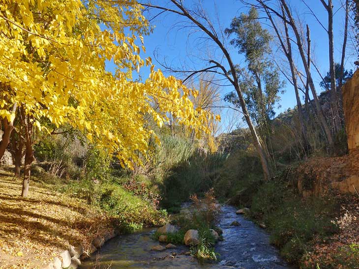
Not far from Valencia, a simple and beautiful hiking route awaits us, ideal for the whole family. The water route of Chelva perfectly combines the history and cultural heritage of this town with the spectacular nature that surrounds it. Water, of course, is the common thread that will accompany us on our excursion. While we visit the neighbourhoods of Chelva, we approach spectacular hidden corners on the banks of the river Tuéjar or Chelva, as it is also known, and we discover part of the history of this area of the Valencian Community.
The town of Chelva is located in the middle of the CV-35 road that connects it directly with Valencia and Tuéjar. The town is also served by other roads that connect it with neighbouring towns.
Once in Chelva we have several possibilities to park our vehicle, of course in the town itself we will have parking spaces available. This is initially the main option as the official start of the route is in the Main Square of Chelva. We can also start the route in the car park of the recreational area of Molino Puerto, in which case we will have to pay the €5 parking fee.
The Main Square of Chelva (0h 00min) is the starting point for this water route. In front of the church of Nuestra Señora de los Ángeles, in a corner of the square we see the information sign of the route and the first waymarks of the route. This first part of the route takes us through the streets of Chelva to visit the old Moorish quarter. Narrow alleys and old fountains enliven the route. Almost without noticing we leave Chelva and head towards the recreational area Molino Puerto, another starting point of the water route.
From here the river Tuéjar is the protagonist of the route.

La Playeta area-CC/Frank Baulo
Water Route-CC/Bealocal Valencia
River Tuétar-CC/Ismasahuqui01

Water Route-CC/Bealocal Valencia
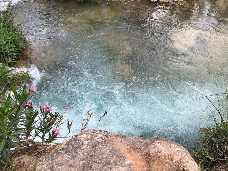
The path takes us along the banks of the river, crossing several bridges to the spot known as La Playeta, one of the magnificent natural pools in Valencia. After enjoying this beautiful spot, we continue on to another of the highlights of the water route, the Olinches Pass, an old water channel excavated in the rock that allows us to cross this area. The tunnel leads back to the path that will take you to the nearby Olinches Dam (0h 55min).
Once we have visited the old dam we retrace our steps back to the Molino Puerto recreational area. Here the less experienced walkers can go up to Chelva and finish the excursion, the rest of us follow the marks of the path that lead us to the Light Factory or Casa de la Luz (House of Light) as it is also known. The river continues to be the protagonist of the route, a somewhat more demanding itinerary in its gradient, with the occasional ramp that makes us try a little harder. The height gained allows us to access the viewpoint from where we can contemplate some magnificent views of Chelva, including the Caves of Montecito, the Peak Remedio and the Torrecilla among other notable figures. After a while we reach the remains of the old House of Light (2h 00min), where the channelled water that came from the dam we have visited used to generate the electricity with which the inhabitants of Chelva used to light up their homes.
The path we were following continues its course towards the village of Calles, and from there continues towards Peña Cortada and its monumental Roman aqueduct. We will retrace our steps, looking for the detour that we will find at the Source of the Cuco, where we passed before arriving at the factory of light. Once there, follow the signs that will take you up the stairs that lead to the Moorish quarter of Arrabal de Chelva, without the need to return to Molino Puerto. The streets of this neighbourhood lead you to the Main Square of Chelva (2h 45min), which is the end of this beautiful walking route.
1-It is a good idea to take a lantern with you through the Olinches tunnel.
2-On the route there are different picnic areas ideal for enjoying the day.
3-The section between La Playeta and the Fuente del Cuco is accessible to pushchairs.
4-The route is easy, although there are some demanding slopes, especially in the final stretch.
 |
 |
 |
 |
 |
| 1-Chelva | 0:00h | 470m | 0km | 30S 671546 4401649 |
| 2-Molino Puerto | 0:20h | 405m | 1.3Km | 30S 670909 4401480 |
| 3-La Playeta | 0:30h | 410m | 1.8Km | 30S 670549 4401624 |
| 4-Olinches Dam | 0:55h | 440m | 2.7Km | 30S 670096 4401371 |
| 5-Factory of Light | 2:00h | 390m | 5.7Km | 30S 672436 4401077 |
Coordinates UTM Datúm WGS84

.png) Distance: 7.5Km
Distance: 7.5Km
.png) Time: 2:45h
Time: 2:45h
.png) Difficulty: Low
Difficulty: Low
 Slope: 650m
 Slope +: 325m
 Slope -: 325m
 Maximum altitude: 470m
 Minimum altitude: 375m

![]()
This schematic with the path is approximate and has been created from the derived cartographic base © Instituto Geográfico Nacional "Cuadrante 666-4 1:25.000".

¿Did you know that...
Chelva was the first village in the Serranía region to have electricity, thanks to the two power stations that were built in the area to harness water power.
Don't miss out...
The visit to the different old quarters of Chelva, the Arab Quarter, the Jewish Quarter, the Moorish Quarter, the Christian Quarters and the Ensanche, where the main monuments of the town are concentrated.


From the commitment of SENDITUR with Nature and the respect to the balance of the environment, SENDITUR urges you to travel in a responsible way, with low environmental impact and respecting at all times the Natural, Cultural and Social environment wherever you go.

Besides sharing with all of us your experience on the route we would be grateful if you could write to us to inform us of any erroneous or outdated information you may have found, or simply to let us know what you think at Thank you.
Route information updated on 23-09-2020. The route may vary greatly depending on the time of year, weather conditions and terrain, as well as the actions of third parties and the evolution suffered in the natural environment where it is located. All opinions, advice and/or assessments made by SENDITUR in their descriptions are for guidance only and are subject to and/or refer to the specific conditions of the specific day of the route, referring to that specific day, taken from trained people, with the appropriate experience and with a high level of physical and technical preparation as a reference, as well as correctly equipped.
All the times are approximate and take an orientative character, the stops have not been taken into account, no matter how small they are. All the information related to the route, texts, images, videos, maps, diagrams, tracks, towns, and places of tourist interest are published as a guide, and may not coincide with the current state of each place. Before undertaking any activity, assess your technical knowledge, your physical condition, find out about the weather and the variations that the route may undergo, equip yourself correctly, be prudent and responsible at all times, and do not exceed your capabilities. SENDITUR is not responsible for any misuse or inappropriate use of the comprehensive guides of its routes and/or publications as well as its electronic guides, nor for any variations in their descriptions for the aforementioned reasons, and recommends that everyone be responsible and prudent in carrying out the activity. We also encourage you to read books and specialised guides to complement the information described above.
Continue watching …


