Welcome to SENDITUR.COM · paths · routes · tourism

![]() Difficulty-Moderate
Difficulty-Moderate
![]() 4:15 h.
4:15 h.
![]() 7.7 km.
7.7 km.
![]() Difficulty-Moderate
Difficulty-Moderate
![]() 4:15 h.
4:15 h.
![]() 7.7 km.
7.7 km.
The Montaña de Riaño y Mampodre Regional Park in the north of León, an antechamber to the Picos de Europa, treasures landscapes of great beauty, emblematic mountains, which have nothing to envy to the great peaks of renown, and charming villages steeped in tradition. The ascent to Gilbo Peak from Riaño allows us to enjoy all these charms, despite the impact that the Riaño reservoir has had on the environment and landscape of this area of León. The climb to Gilbo Peak, whose silhouette has earned it the nickname of the Leonese Cervino, is a route that requires almost equal parts effort and caution. In addition to the considerable slope that is concentrated in the final stretch of the ascent to the summit of Gilbo, there are some vertical and exposed areas, which, although they do not involve significant technical complications, do require a certain amount of preparation and experience.
There are several ways to get to Riaño. We can get there from the city of León itself, following the N-625 national road that connects it with Cangas de Onís, passing through Riaño. Or we can do it from the town of Potes via the N-621 national road. Once in Riaño we can park our vehicle in the town itself and start the route from there or we can do so in the car park we will find on the same road, just before crossing the viaduct over the reservoir as we arrive from León.
If our starting point is the Gilbo parking area, on the road before arriving at Riaño from León, we will avoid the 1.5 km that separates us from this beautiful village Leonese. In front of this small parking area, the path we must follow awaits us, which will take us along the edge of the reservoir. At least for a short time, as almost before we know it we reach the bend in the road where the beginning of the path that we must follow awaits us.
We leave behind the track we came along to start going up the Vallarqué stream, which gives its name to the beautiful beech forest we are entering.
The route takes us in search of the headwaters of the stream, where we leave the lush forest. The pastureland in which we now find ourselves allows us to contemplate part of the spectacular views that we are going to be able to enjoy on this interesting route. Also to our right we can see the Gilbo crest and the pass towards which we should head. The stone milestones help us to follow the right path that will lead us, not without effort, to the Col of The Pedrera (1h 25min). Just before reaching it we leave behind us the path that we follow along the ridge to return from here to the parking place.

Ascent of Gilbo Peak from Riaño-CC/Pelayo Carmelo

Section up to the La Pedrera pass-CC/Pelayo Carmelo

Ascent to the summit canal-CC/Pelayo Carmelo

Once at the top of the col we take a break to catch our breath and enjoy the magnificent views from here. After the more than advisable pause we resume the route to tackle, now on the opposite slope from the one that brought us here, the final stretch of the ascent to Gilbo Peak. This part of the route also has stone milestones that will help us to follow the correct path of the many options that we have to choose from. In any case, the mountain wall serves as a reference point to follow, and we should not stray from it, as the paths that do so may cause us unnecessary difficulties. Even so, we must be careful as we will pass some exposed sections where we will have to help ourselves with our hands. If we are not confused and provided we have the necessary experience and preparation, these sections should not be a problem, although snow, ice and humidity should not be the protagonists. Little by little we gain height until we reach a kind of privileged balcony, another of the unavoidable stops to enjoy the views and catch our breath. From here we only have to go up the small channel that ascends to the summit of Gilbo Peak (2h 35min), where a spectacle for the senses awaits us.

Final stretch of the ascent along the canal-CC/Pelayo Carmelo
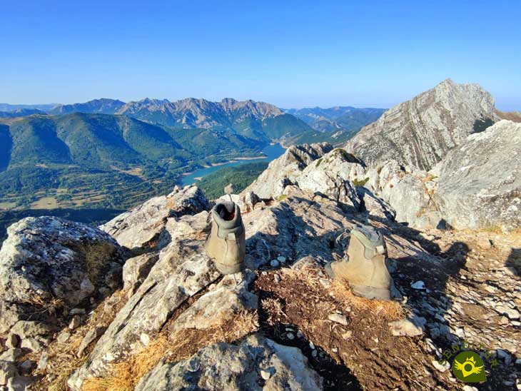
Mountaineering boots on the Gilbo summit-CC/Pelayo Carmelo

Gilbo Peak summit-CC/Pelayo Carmelo

Ridge of Gilbo Peak-CC/Pelayo Carmelo
The Rionda Rock, the Villares Mountains, the Cerroso, the Mampodre, are just some of the giants that we can contemplate from the Gilbo, without forgetting the views of Riaño and its reservoir or the stately Picos de Europa. After spending some time on the summit of Gilbo we begin the descent, we can do so by following the ridge in the opposite direction to the one we came until we come across the milestones that mark the beginning of the descent, but this option is much more exposed and complicated than returning to the Col of The Pedrera by the same route by which we climbed Gilbo.
Once in The Pedrera we leave on our right the path we used to climb to the col from the beech forest, to skirt Sarnosa Rock, leaving it on our left.
On the other side there is a new pass that separates Sarnosa from Vallarqué Rock. This is the start of the path that descends into the Biescas beech forest. The descent through this forest is simply spectacular, and almost without noticing we pass by the detour that goes up to the nearby cave of the Old Woman of the Mount, which is a must-see. The end of the beech forest leaves us almost in the middle of the recreational area of Las Biescas. From here we only have to return to the parking area following the path that borders the Riaño reservoir. A path that quickly closes the circle of this route, taking us to the Gilbo parking area (4h 15min), where we will put an end to this beautiful route.
1-Another possible route of ascent to Gilbo Peak starts from the nearby village of Horcadas, there are people who leave a vehicle at each place to go up both slopes in a single day.
2-The verticality and exposure of some parts of the route can impress people unaccustomed to this type of activity, increasing the risk, so be cautious.
3-The slope to overcome is concentrated in just 2.3 km, being more evident in the final part of the ascent, forcing us to be in good physical condition and to take the route slowly.
4-While in normal summer conditions the route is accessible, in winter with ice and snow the difficulty and technical demands are considerably increased, leaving the route reserved for people with the necessary experience and equipment.
 |
 |
 |
 |
 |
| 1-Parking | 0:00h | 1115m | 0Km | 30T 335371 4759232 |
| 2-Col of ThePedrera | 1:25h | 1440m | 2,8Km | 30T 333472 4758357 |
| 3-Gilbo Peak | 2:35h | 1677m | 3,5Km | 30T 333111 4758182 |
Coordinates UTM Datúm WGS84

.png) Distance: 7,7Km
Distance: 7,7Km
.png) Time: 4:15h
Time: 4:15h
.png) Difficulty: Moderate
Difficulty: Moderate
 Slope: 1260m
 Slope +630m
 Slope -630m
 Maximum altitude: 1677m
 Minimum altitude: 1115m

![]()
This schematic with the path is approximate and has been created from the derived cartographic base © Instituto Geográfico Nacional "Cuadrante 105-1 y 105-2 1:25.000".

Una ruta que me ha gustado mucho!!

From civilization to the mountains of the central massif of the Picos de Europa


Sistine Chapel of Romanesque Art, palatine temple of the kings Fernando I and doña Sancha


¿Did you know that...
The Riaño reservoir, built in 1987, regulates the waters of the river Esla, flooding a valley full of typical villages in the mountain Leonese region.
Don't miss out...
The visit to Riaño and Horcadas, although the original Riaño lies under the waters of the reservoir, the new one is well worth a stroll through its streets with the calm what does it bring of the surrounding landscape.


From the commitment of SENDITUR with Nature and the respect to the balance of the environment, SENDITUR urges you to travel in a responsible way, with low environmental impact and respecting at all times the Natural, Cultural and Social environment wherever you go.

Besides sharing with all of us your experience on the route we would be grateful if you could write to us to inform us of any erroneous or outdated information you may have found, or simply to let us know what you think at Thank you.
Route information updated on 28-08-2021. The route may vary greatly depending on the time of year, weather conditions and terrain, as well as the actions of third parties and the evolution suffered in the natural environment where it is located. All opinions, advice and/or assessments made by SENDITUR in their descriptions are for guidance only and are subject to and/or refer to the specific conditions of the specific day of the route, referring to that specific day, taken from trained people, with the appropriate experience and with a high level of physical and technical preparation as a reference, as well as correctly equipped.
All the times are approximate and take an orientative character, the stops have not been taken into account, no matter how small they are. All the information related to the route, texts, images, videos, maps, diagrams, tracks, towns, and places of tourist interest are published as a guide, and may not coincide with the current state of each place. Before undertaking any activity, assess your technical knowledge, your physical condition, find out about the weather and the variations that the route may undergo, equip yourself correctly, be prudent and responsible at all times, and do not exceed your capabilities. SENDITUR is not responsible for any misuse or inappropriate use of the comprehensive guides of its routes and/or publications as well as its electronic guides, nor for any variations in their descriptions for the aforementioned reasons, and recommends that everyone be responsible and prudent in carrying out the activity. We also encourage you to read books and specialised guides to complement the information described above.
Continue watching …


