Welcome to SENDITUR.COM · paths · routes · tourism
![]() Difficulty-Low
Difficulty-Low
![]() 2:30 h.
2:30 h.
![]() 7 km.
7 km.
![]() Difficulty-Low
Difficulty-Low
![]() 2:30 h.
2:30 h.
![]() 7 km.
7 km.
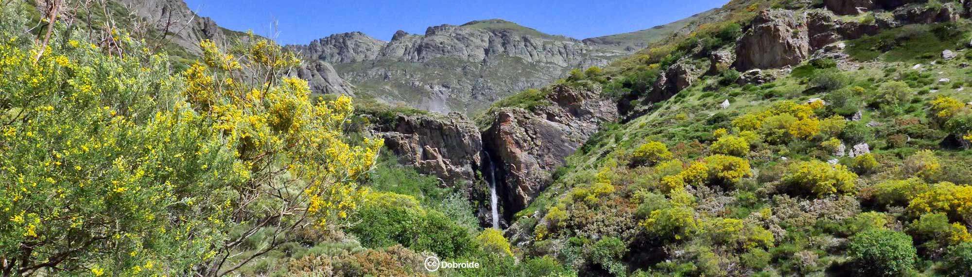
The Natural Park of Sources Carrionas and Source Copper is a true temple of nature, ideal for hiking enthusiasts. There are countless places and routes to be found in this area of the province of Palencia. Itineraries that will take us to the top of mythical mountains or to places of great beauty. One of these hiking routes in the Mountain Palentina that we can not miss is the Path of the Mazobre Waterfall, an easy and beautiful route that takes us to the largest waterfall in Palencia, escorted at all times by the colossal Espigüete Peak, one of the lords of the Mountain Palentina.
The starting point of the Path of the Mazobre Waterfall can be found on the road that links Cardaño de Abajo with Cardaño de Arriba. To get to Cardaño de Abajo we have to follow the road known as the Route of the Reservoirs, which links Cervera de Pisuerga with Velilla del Río Carrión, passing through Cardaño de Abajo. It is on this road where we will find the turning that leads to Cardaño de Arriba and just over 2 km further on, once we have taken the turning, the Pino Llano parking area awaits us, appropriately signposted, from where this and other routes that cross this area of the Mountain Palentina begin.
As you know, the Pino Llano parking lot is the starting point for this beautiful route in the Natural Park of Sources Carrionas and Source Copper. The informative signpost marks the beginning of the route. The route starts to follow the generally dry course of the Mazobre stream. The limestone rocks that characterise these mountains mean that, with few exceptions, the flow of the stream runs underground, although fortunately the waterfall usually has water all year round.
After a while we will leave a path on the left that ascends towards the Mazobre refuge in the middle of the Majada del Espigüete, whose north face we will cross with enough distance to be able to admire it calmly.
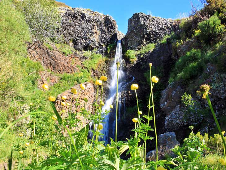
The white and yellow markings of the PR-P6 are in charge of guiding us at all times on this route, which should not make it very difficult to follow its course. Once again we come across another detour which, if we follow it, will take us to the Mazobre refuge, a more than advisable detour, given the landscapes that can be enjoyed from its location, which we can leave for the way back. We continue in search of the waterfall that we can already begin to sense in the distance. After a while and after crossing, thanks to a wooden bridge, a stream that flows in search of the ravine we are climbing, we will reach a new fork. Here we follow the path on our right that takes us quickly to the viewpoint of the Mazobre waterfall (1h 00min).

Waterfall of Mazobre-CC/Dobroide

Waterfall of Mazobre-CC/Julen Iturbe
Waterfall of Mazobre-CC/Parque natural montaña palentina

Once at the viewpoint and after admiring the waterfall, we can descend to its base following the steep path that leads down to it. For many visitors to this emblematic spot in the Mountain Palentina, this is the end of the route. In our case, we decided to take the opportunity to visit another of the beautiful waterfalls that are found here. Again at the fork that leads to the viewpoint, instead of returning to Pino Llano we continue ascending following the course of the stream as we did to get here. Not far away awaits us the beautiful Martín Vaquero waterfall (1h 30min), a little more modest than the previous one, but without any doubt rivalling in beauty. Once we have enjoyed this natural spot, we return to the parking place of Pino Llano (2h 30min) following the same path we took to get here.
1-This is an a priori simple route, ideal for families with children, but don't underestimate it.
2-Summer, autumn and especially spring with the thaw are the best times to visit the Mazobre Waterfall, in winter with snow there are those who approach with snowshoes but it requires experience in this type of situation.
3-From the Pino Llano car park there pull out more routes apart from the Path of the Waterfall of Mazobre, and it is not characterised by having many parking spaces, so it is advisable to get up early in the morning to avoid problems.
4-Bear in mind that you are at an altitude of more than 1300 m, so be properly equipped and wear warm clothes even in summer.
 |
 |
 |
 |
 |
| 1-Pino Llano | 0:00h | 1340m | 0Km | 30T 356293 4756915 |
| 2-Mazobre waterfall | 1:00h | 1605m | 3Km | 30T 353780 4757845 |
| 3-Martín Vaquero Waterfall | 1:30h | 1680m | 3,5Km | 30T 353611 4758156 |
Coordinates UTM Datúm WGS84

.png) Distance: 7Km
Distance: 7Km
.png) Time: 2:30h
Time: 2:30h
.png) Difficulty: Low
Difficulty: Low
 Slope: 690m
 Slope +345m
 Slope -345m
 Maximum altitude: 1680m
 Minimum altitude: 1340m

![]()
This schematic with the path is approximate and has been created from the derived cartographic base © Instituto Geográfico Nacional "Cuadrante 106-1 1:25.000".

¿Did you know that...
In this area of the Natural Park of Sources Carrionas and Source Copper, given its characteristics, there are chasms of incalculable size, through which water flows, as well as sinkholes of surprising shapes.
Don't miss out...
The Alba de Los Cardaños Viewpoint, which you will find on the road that leads to Cervera de Pisuerga shortly after passing through Cardaño de Abajo, from where you can enjoy marvellous views of this area of the Mountain Palentina.


From the commitment of SENDITUR with Nature and the respect to the balance of the environment, SENDITUR urges you to travel in a responsible way, with low environmental impact and respecting at all times the Natural, Cultural and Social environment wherever you go.

Besides sharing with all of us your experience on the route we would be grateful if you could write to us to inform us of any erroneous or outdated information you may have found, or simply to let us know what you think at Thank you.
Route information updated on 02-06-2021. The route may vary greatly depending on the time of year, weather conditions and terrain, as well as the actions of third parties and the evolution suffered in the natural environment where it is located. All opinions, advice and/or assessments made by SENDITUR in their descriptions are for guidance only and are subject to and/or refer to the specific conditions of the specific day of the route, referring to that specific day, taken from trained people, with the appropriate experience and with a high level of physical and technical preparation as a reference, as well as correctly equipped.
All the times are approximate and take an orientative character, the stops have not been taken into account, no matter how small they are. All the information related to the route, texts, images, videos, maps, diagrams, tracks, towns, and places of tourist interest are published as a guide, and may not coincide with the current state of each place. Before undertaking any activity, assess your technical knowledge, your physical condition, find out about the weather and the variations that the route may undergo, equip yourself correctly, be prudent and responsible at all times, and do not exceed your capabilities. SENDITUR is not responsible for any misuse or inappropriate use of the comprehensive guides of its routes and/or publications as well as its electronic guides, nor for any variations in their descriptions for the aforementioned reasons, and recommends that everyone be responsible and prudent in carrying out the activity. We also encourage you to read books and specialised guides to complement the information described above.
Continue watching …


