Welcome to SENDITUR.COM · paths · routes · tourism


![]() Difficulty-Moderate
Difficulty-Moderate
![]() 3:05 h.
3:05 h.
![]() 8.2 km.
8.2 km.
![]() Difficulty-Moderate
Difficulty-Moderate
![]() 3:05 h.
3:05 h.
![]() 8.2 km.
8.2 km.
In the pre-Pyrenees of Huesca stands Oroel Rock, whose unique profile is visible from almost anywhere in Jaca, a city very close to this mythical peak that dominates the wide valleys that fall on either side of it. The rich environment that surrounds it and an ecosystem that shelters a great variety of animal and vegetable species is another incentive to climb to the summit of this mountain from where we will enjoy a wide panoramic view that undoubtedly makes this a magical summit.

The 8.2 km ascent to Oroel Rock starts from the car park of the Hostel of Oroel, taking us on a tireless and winding ascent through the interior of the forest that populates its slopes. The fir trees cling to the north face of the mountain through which we are ascending looking for the humidity, so necessary for them, and which they find in this natural park. The inhabitants of the forest we are walking through do not cease their daily tasks, allowing us to listen, if we pay attention, to the incessant hammering of the woodpeckers in search of their food. The leafy forest gives way to an extensive prairie that, at the end of the ascent, lets us go through the mountain pastures full of erizones, radically changing the landscape that has surrounded us up to this point.

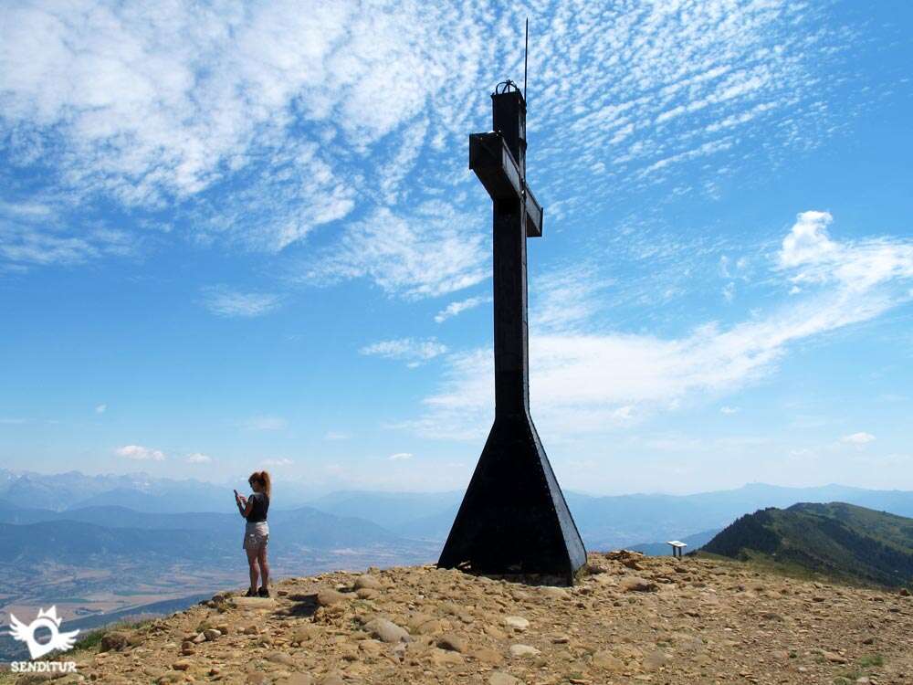
The many trails that run through this area come out to meet us, trails that if followed would lead us to, for example, Baros or Navasa among many other places. One of them is the Path of the Hermitage of the Virgin of the Cave that precedes the final part of the ascent that we still have ahead of us. The summit of Oroel Rock awaits us to let us immerse ourselves in its privileged views that allow us to contemplate some great Pyrenean peaks next to the fertile valleys that stretch out at our feet. The imposing cross that stands on its summit reminds us of the history of the reconquest of Aragon, which is said to have begun with the bonfires that were made here. Time passes without us realizing how much this beautiful mountain offers us, scrutinizing the horizon trying to identify each mountain, each village or the hidden Monasteries of San Juan de la Peña, part of this protected landscape next to the Oroel Rock.

We descend calmly, following our own steps and letting ourselves be led to the Fountain of the Foresters next to the car park of the Hostel of Oroel where some time ago we had begun the journey and where we can contemplate the now small cross that defies the void. In this same place we have a beautiful rest area in the shade of the trees and another privileged viewpoint that will give us a different perspective of the valley and the mountains that surround Jaca.
More information about the itinerary is available. DO NOT MISS IT...
According to the legend, a fearsome dragon lived in Peña Oroel and frightened the whole region. Its inhabitants commissioned a courageous knight to free them from that beast, which only by looking at it could make their enemies fall down dead instantly. The knight devised a cunning plan, which consisted of polishing his shield until it reflected like a mirror everything that was placed in front of him. Then the knight looked for the dragon that was sleeping peacefully in his cave, and when he felt it, the dragon woke up. And when he saw himself reflected in the knight's shield, he fell dead by his own power. The knight then took the opportunity to mercilessly plunge his sword into his heart, thus freeing the region from such a dangerous dragon.
To get to Jaca we can do so by following the N-240 that comes from Pamplona, we can also do so from Sabiñanigo following the E-7 that comes to this town from Huesca, this same road, but on its other side, communicates Jaca with Canfranc and France. Another option is the A-1205, where you will find the detour to the start of the route and which links Jaca with the towns of Bernués and Anzánigo. Once in Jaca, at the roundabout where all these roads meet, on the arrival in Jaca of the N-240 from Pamplona, we will also find the A-1205, towards Bernués, where we will have to continue. A few kilometres after crossing over the River Gas, already in the middle of the climb to the Oroel Pass, you will find yourself on the left, and on the right for those coming from the opposite direction, with the track that will take you to the Oroel Parador, where you will find the small car park where you can leave your vehicle. Those who come in the opposite direction must go down the port until they reach the crossroads with the badly damaged track that leads to the Parador. We will recognise this track by the signs that indicate both that we are in the natural park and the direction to the Parador. We can also reach the Parador on this same track but on the other side, whose access is on the HU-V-3011 near the town of Navasa. This road crosses diagonally from Hostal de Ipiés on the E-7, shortly before reaching Sabiñanigo from Huesca, to the same E-7 near Jaca.
A magnificent route in the middle of nature that will require our friend to make a good effort to climb the slope that separates us from the summit. Otherwise the distance, not too long, allows us to be able to dose him so that the unevenness is not a problem. Be careful with the many trails and animal crossings that we will go through if our friend goes into them, it is very easy to get lost.
We will only have one water point in the car park where we start so it is important to carry the necessary reserves, the relatively short distance of the route should not make us fall into the error of not carrying water for him. In summer, although the strongest route is through the interior of the forest protected by the shade of the trees, the heat is still noticeable and will undoubtedly make us need more water.
We are in a protected natural area so as a rule pets should be tied up, due to the large influx of people is not usually very common to meet with the fauna that inhabits these lands, except birds, even so it goes without saying that we must respect them and not disturb the animals that live here. For the rest, we will surely come across more than one intrepid friend who accompanies his family on this beautiful walk.
We begin the route next to the parking lot (0h 00min) of the Parador of the Viewpoint of Oroel, in front of us we can contemplate the impressive mass to which we prepare to ascend.

Just at the entrance to the car park on the continuation of the track from Jaca, we find the beginning of the path that we must follow to reach the summit. We start a climb that from the beginning shows us its marked character, conditioned by the unevenness we have to overcome and the relatively short distance used for it.

The route runs through a lush forest that contributes to the shade of its trees to reduce some of the demand that hot days have. The path we follow leads us without giving us a break, looking for the best way to overcome the unevenness that lies ahead.

The clearly defined route, but decomposed in part by the action of the water and the ice, lets us see the tangle of roots that furrow it and make the already costly progress difficult.

The trail twists more and more until it starts the typical zigzagging of the paths that overcome a great unevenness. At each turn, we find narrow trails, some more visible than others, which we do not have to follow. The terrain, which is held together by logs that act as steps, alternates between areas in relatively good condition and others that are completely decomposed.

In one of the many changes of direction we will make, we will find a path that could well deceive us, making us go straight, but thanks to a solitary sign and several trunks that delimit our path, we will be able to follow the correct route.

This part of the journey forces us to progress even more calmly given the state of the terrain which is quite decomposed.

Little by little, we are gaining height, which contributes to the sun's rays slipping more easily through the trees around us. The steps of the trunks leave us, giving way to a narrow and well trodden trail that still bites upwards.

Soon we are deprived of the protection provided by the trees, almost at the same time that the slope that was asking for so much effort disappears. The bushes are now our companions and the ones in charge of guiding us for a few meters.

As soon as we go out into the open, we come across a path that joins us on our left. In front of us we have two options, the first one will take us cresting up to the surroundings of the summit, the second one will make us descend a few meters following the path that half way up the hillside continues towards the summit, for now without any major effort.

This trail goes uphill without major demands surrounded by scrub and bush, which allows us to enjoy good views of the mountain range that houses the Monasteries of San Juan de la Peña.

Soon we find ourselves at the beginning of the Path of the Hermitage of the Virgin of the Cave (1h 40min), which descends to our left down the hillside.

We continue straight on, following the trail that cuts through the green mantle of the mountain, leading us without any loss to our destination which we can already see in front of us. The adventurers who chose to follow the crest of the mountain to enjoy the impressive views are already waiting for us at the summit.

Together we overcome the remaining slope, to finally reach the great cross that dominates the summit of Oroel Rock (2h 00min), from where we can enjoy the privileged views that this mountain offers to those who climb it. Next to the cross, the summit landmark and on the other side the sign that helps us to discover the peaks of the Pyrenees on the horizon.

The summit shoulder extends a few more meters inviting us to walk along it to look at the other side of the valley that is still hidden from us.

After regaining strength and enjoying the summit and its surroundings, we start the return journey that follows the same itinerary that brought us here, taking us on a quick descent again to the car park (3h 05min), where the route ends.
 Distance 8.2Km
If we go down to the hermitage we must add this distance to this figure.
 Time. 3:05h
This time is calculated with good weather conditions, without snow or ice that would undoubtedly increase the time needed to make the tour. If we dare to descend to the hermitage of the Virgin of the Cave we will have to add 1h 00min more approximately.
 Time of year
This summit and the surrounding environment offer us special and changing conditions throughout the year, the type of vegetation, the animals that inhabit the area and above all the spectacular views that can be contemplated from this privileged viewpoint, added to the fact that the most demanding part of the route is protected by a thick forest, make this a perfect route even in the middle of summer. The winter brings its special colour to this route but the snow or ice that we will undoubtedly find makes it unsuitable for alomst everyone.
 Required equipment
The route in summer allows us to use a pair of boots or trekking shoes, although some parts of the route are somewhat bare the path is equipped with strategically placed steps. Of course, we must adapt our equipment to the weather conditions we find, taking into account that when we go out to the top we will be at the mercy of the wind that can make the thermal sensation drop quite a bit, making us have to keep warm, even at the beginning of the hottest dates. The camera is undoubtedly a good companion and the poles can be of great help both in the climb and in the descent. In the backpack we can't miss the water and something to eat since we don't have to find fountains in the whole route, except at the beginning and its water is not treated. Consult our list of material and equipment for hiking. Read more.
 Difficulty. Moderate
Physical
This is a demanding ascent due to the slope to be overcome and the short distance in which it is done, although the relatively short length of the route and the shade that we will be able to enjoy in the part with the greatest unevenness contribute to giving us the necessary margin to be able to take the ascent with the necessary calm. The apparent smoothness of the final stretch may make us think that it does not have the true unevenness that we will really still have to overcome.
Severity of the environment
The roots of the trees and some parts of the ascent that are quite stony are the biggest complications that we will find, especially if they are wet, forcing us, especially on the descent, to progress with some caution to avoid unnecessary slips. Pay attention to the top shoulder, since the vertical fall we have is very important if we lean out too much on its edge and the ground has enough loose stone. Otherwise the route does not present great technical difficulties allowing access with relative ease.
Orientation
The ascent coincides in part with one of the homologated paths of Huesca so it is well signposted. In addition, the perfectly defined path helps to dispel almost any doubt. At the few crossroads where several clearly marked routes coincide, we have the corresponding markers that clearly indicate the course to follow. Be careful not to leave the marked path, especially if there is fog, we can easily get disoriented, also the large number of routes that cross this area can make us doubt at some point, although the route we follow does not make us deviate, leading directly to the summit.
 |
 |
 |
 |
 |
| 1-Parking | 0:00h | 1181m | 0Km | 30T 702703 4711325 |
| 2-Path of the Hermitage | 1:40h | 1666m | 2.9Km | 30T 703007 4710259 |
| 3-Oroel Rock | 2:00h | 1772m | 4.1Km | 30T 701880 4710472 |
| 4-Path of the Hermitage | 2:10h | 1666m | 5.3Km | 30T 703007 4710259 |
| 5-Parking | 3:05h | 1181m | 8.2Km | 30T 702703 4711325 |
Coordinates UTM Datum WGS84

 Slope: 1218m
 Slope +: 609m
 Slope -: 609m
 Maximum altitude: 1772m
 Minimum altitude: 1181m

This sketch of the route is not made to scale nor does it contain all the information relating to the area, it is merely indicative.

![]()
This schematic with the path is approximate and has been created from the derived cartographic base © Instituto Geográfico Nacional "Cuadrante 176-4 1:25.000"
Senditur has manipulated the tracks to correct the aberrant points that may exist, caused by problems with the reception of the GPS signal. In any case the tracks are always approximate. SENDITUR encourages you to use the new technologies within your reach, using them as support and consultation in your activity, not basing the realization and orientation of the same only and exclusively on them, since they may see their functioning altered by very diverse causes, not functioning correctly and their indications may not be precise.


Bonita cima!!!


Pilgrimage destination in honour of the patron saint of Navarre, Saint Francis Xavier

Find out what to see in...
¿Did you know that...
As a general rule we can get to orient ourselves and know where the north is without the need for a compass, we only have to look at the tree trunks to see where the moss and lichen grow, which thanks to the fact that the shade conserves humidity better, develop on the side of the tree facing north. This fact in some cases is quite conditioned not being one hundred percent effective and just proving the quality of the air around us free of pollution.
Don't miss out...
The Monastery of San Juan de la Peña, an impressive monumental complex that mixes art and culture with the exuberant nature of the natural space that surrounds it and of which Oroel Rock is a part. The Old Monastery, a jewel of the Middle Ages, goes into the rock looking to be part of the mountain and the new Monastery in Llano de San Indalecio, a wide prairie from which countless routes start.


From the commitment of SENDITUR with Nature and the respect to the balance of the environment, SENDITUR urges you to travel in a responsible way, with low environmental impact and respecting at all times the Natural, Cultural and Social environment wherever you go.

Besides sharing with all of us your experience on the route we would be grateful if you could write to us to inform us of any erroneous or outdated information you may have found, or simply to let us know what you think at Thank you.
This route has been carried out in the field by SENDITUR on 04-07-2015. The route may vary greatly depending on the time of year, weather conditions and terrain, as well as the actions of third parties and the evolution suffered in the natural environment where it is located. All opinions, advice and/or assessments made by SENDITUR in their descriptions are for guidance only and are subject to and/or refer to the specific conditions of the specific day of the route, referring to that specific day, taken from trained people, with the appropriate experience and with a high level of physical and technical preparation as a reference, as well as correctly equipped.
All the times are approximate and take an orientative character, the stops have not been taken into account, no matter how small they are. All the information related to the route, texts, images, videos, maps, diagrams, tracks, towns, and places of tourist interest are published as a guide, and may not coincide with the current state of each place. Before undertaking any activity, assess your technical knowledge, your physical condition, find out about the weather and the variations that the route may undergo, equip yourself correctly, be prudent and responsible at all times, and do not exceed your capabilities. SENDITUR is not responsible for any misuse or inappropriate use of the comprehensive guides of its routes and/or publications as well as its electronic guides, nor for any variations in their descriptions for the aforementioned reasons, and recommends that everyone be responsible and prudent in carrying out the activity. We also encourage you to read books and specialised guides to complement the information described above.
Continue watching …


