Sarrios Valley from Lizara
Aragüés del Puerto, Huesca![]()
![]()
![]()
![]()
![]() (0)
(0)
Following in the footsteps of the GR 11 and the Path of Camille
Aragüés del Puerto, Huesca![]()
![]()
![]()
![]()
![]() (0)
(0)
Following in the footsteps of the GR 11 and the Path of Camille
Not far from the well-kept villages of Jasa and Aragües del Puerto, in the heart of the Valles Occidentales Natural Park, magnificent natural landscapes and beautiful hiking routes await us. One of these routes takes us to the Sarrios Valley from Lizara, following the route of the GR 11 and the Path of Camille as it passes through this area of Huesca.

The 13.3 km route is a linear itinerary that starts at the Lizara hut and climbs calmly through the ravine between the Bernera massif and the mythical Bisaurín. The route takes us to the small Oldecua hut and with each step we go deeper into the ravine to get closer to the next hut we are going to visit, the Foresters' Hut. The landscape changes radically when we reach the Llanos de Bernera or the Plana de Mistresa, as this green spot is also known. Little by little, surrounded by the steep peaks that mark our route, we approach the Sarrios Valley, but not before making a stop on the way to visit the charming Old glacial lake, hidden from the gaze of the hikers who follow this section of the GR 11.

The Bernera col marks the stony descent that will take us to the very heart of the Sarrios Valley. Here many people continue their walk along the GR 11 to visit the Estanés glacial lake, in our case we take a detour in search of a different view of this Pyrenean colossus. We go up the hill that closes the valley on the left side, as we walk, to find the privileged balcony from where we can enjoy this great Estanés glacial lake. From there, following our footsteps, we start the return route that will take us back to the Lizara hut.

Many years ago a young shepherd used to frequent the green meadows of the Sarrios Valley with his flock. Such was the shepherd's union with nature and the animals that even the wild sheep ended up joining his flock. The shepherd became seriously ill and, knowing that he had little time left to live, he went to pray at a small hermitage in the area, asking to be allowed to go up, if only once more, to his green valley. Nothing more is known of the shepherd, but according to legend it is not unusual to find the sheep around the large stones in the middle of the valley, stones that are right where the shepherd and his dogs used to sit to rest and spend the day.
To get to the Lizara hut we have to follow the road that connects Puente la Reina de Jaca with Hecho. On this road we will find the turning that leads to the towns of Jasa and Aragües del Puerto. Once in Aragües del Puerto, we only have to follow the road that goes up to the Lizara hut. Once there, there are several areas where you can park your vehicle.
A nice route to do with our friend, with no great difficulty as long as he is used to following us on this type of route.
Although it is most likely that we will have areas where he can drink all he needs, it is not a bad idea to bring him some extra water as these areas where he can drink are practically all concentrated on the same stretch of the route.
We are in a livestock area and in a natural park with specific rules for pets, the main one being that we must always keep our dog on a leash and of course we must not disturb the animals in the area.
The car park of the Lizara refuge (0h 00min) marks the starting point for this hiking route in the Pyrenees.

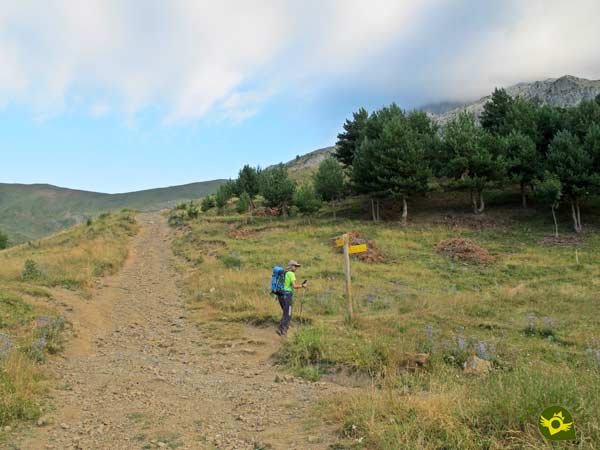
On the side of the hut the path awaits us, which we must follow and which begins the long ascent ahead of us.

This trail quickly takes us to the path that leads to the Foratón pass, the route followed by mountaineers to climb Bisaurín from the Lizara refuge. This stretch of path allows us to contemplate the wide gorge that we are about to cross.

After a short while we come across the turn-off that we must follow, saying goodbye to the path that leads to the pass. The trail that we are following makes us gain altitude fairly quickly as we walk through a beautiful forest that offers us the little shade that we will have all day.

Almost without noticing it, the silhouette of the Oldecua shelter appears before us, although our path hardly comes close to it.

Once we leave the refuge behind us, the slope begins to give us a small respite, these less demanding sections are very common along the entire route.

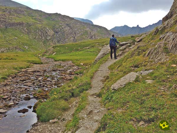
Little by little we go up the ravine following the paved path that cuts through the mountainside.

After a while a metal gate, which prevents the passage of livestock, forces us to take a short break to go through it. The upper part of the ravine we are climbing seems to be getting closer and closer.

Although there is still the typical zigzagging that allows us to overcome this final stretch. But this is not really the end of the ravine, as after overcoming this step more steep slopes await us as we continue to gain height.

The GR 11 markings continue to indicate a path that leaves little room for doubt. Soon we will reach a new section that winds through the mountain looking for the most comfortable way to overcome this steep part of the route.

After regaining our lost orientation, the welcoming forest refuge awaits us in front of us, a magnificent place to take a break and catch our breath. We say goodbye to the refuge to walk the last stretch of this part of the ascent.

Little by little the Plana Mistresa or Llano de Paúl de Bernera, as it is also known, opens up before us. Before reaching it we have the option of crossing the river to follow the GR 11 markings on the other side.

But if we don't want to do it or if the river is too strong, we can continue a little further, as just at the entrance to the plain, on our right, after crossing the river, the path that borders this green plain of Mistresa awaits us.

Both options join a little further on, and together they continue up this part of the route. Not far ahead we come to another fork. Here, unless we are very attentive, we will not see the GR 11 markings that lead us to the option on the right, which is much less trodden.

In any case, both possibilities run parallel to each other, one in the middle of the slope and the other along the lower part of the valley.

The two routes join a little further on, just where a small detour awaits us, which, if we follow it, will take us to the small Old glacier lake. If we have approached the lake there is no need to go back, we can return to the path a little further on.

Once on our path we reach the Bernera pass, the highest point on our route. From here we will begin the stony descent that will take us to our destination today.

Almost without realising it, the majestic Sarrios Valley (3h 10min) appears before us, which we reach by following the well-defined path that has served as a guide until now.
With our main objective achieved, we leave the GR 11 path that continues its course towards the Estanés lake, approximately 1.8 km from where we are, and we head towards a privileged balcony that will allow us to contemplate this spectacular lake from a different panoramic viewpoint.

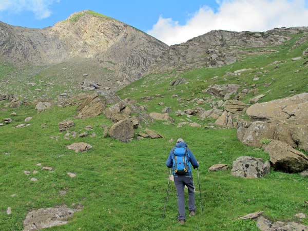
We have to climb a few metres up the side of the mountain to our left, almost at the end of the valley, following what looks like a kind of trail that is rather blurred by the vegetation.

The slope is obvious but nothing compared to the more than 200 m that we would have to climb to return to Lizara if we go down to the Estanés glacial lake.

This part of the route is not marked and, as I have already mentioned, the trail is barely discernible, so we have to find the best way to gain altitude.

We wind our way along the hillside using what looks like the dry riverbed of a torrent as a reference point.

We look for the small pass between the two hills in front of us. Little by little, the slope gradually becomes less steep, allowing us to enjoy the valley at our feet.

Once over the pass, the only thing left to do is to get closer to this improvised viewpoint (3h 40min), with magnificent views of the Estanés lake and other wonders of this area of the Pyrenees.
Once we have enjoyed this spot we return to the Sarrios Valley following our steps and once there we return to the path by which we reached the valley to return to the Lizara mountain hut.

The return trip is easy, following the same route, taking care, once we reach the Bernera pass, not to get the wrong path and follow the one that goes up to Liouviella Peak.

After the detour to the Old lake we can take the path that we rejected on our way up and thus get to know the other itinerary first hand. Another point where we must be attentive is at the exit of the Llano de Paúl de Bernera and not skip the path that descends next to the river. Once we have passed these places we only have to follow the path that will take us to the Lizara mountain hut (5h 36min) where we will put an end to this beautiful hiking route.
This figure covers both the detour to the viewpoint and the Old Lake.
This time includes both the detour to the Old Lake and the ascent to the Estanés Lake viewpoint.
This route is designed for summer conditions, as in winter with snow or ice, its difficulty and demands are considerably increased. Be careful on very hot days, as there is no shade on almost the entire route. Beware of fog and storms, this is an area prone to both.
Initially, and weather and terrain conditions permitting, this is a route that does not require very technical equipment. Hiking or trekking boots or shoes, your rucksack with the essentials and clothes according to the weather conditions that you may encounter. It is important to carry enough water and food, and walking poles will also be a good companion on the route. Consult our list of material and equipment for hiking. Read more.
Physical
For a mountain route in the Pyrenees this is not a physically demanding itinerary, given its distance and gradient, as long as we are used to this type of activity. Another very different thing is if we decide to go down to the Estanés lake, in which case the difference in altitude and the additional kilometres considerably increase the physical demands of the route.
Severity of the environment
In this section, as always, we refer to the conditions we found at the time of the route, i.e. summer conditions and good weather. At first glance it may appear to be an itinerary without major difficulties beyond the usual mountain trails. This is partly the case, although we must bear in mind that we will be crossing areas that are somewhat exposed to possible rockfalls.
Orientation
It is well signposted, with the GR 11 and the Camille path markings that coincide with our route at all times. The only section that is not signposted and where a path to guide us is conspicuous by its absence is at the turn-offs to both the Ibón Viejo and the Estanés lake viewpoint. Even so, we must be attentive as there are quite a few trails and footpaths that we will come across.
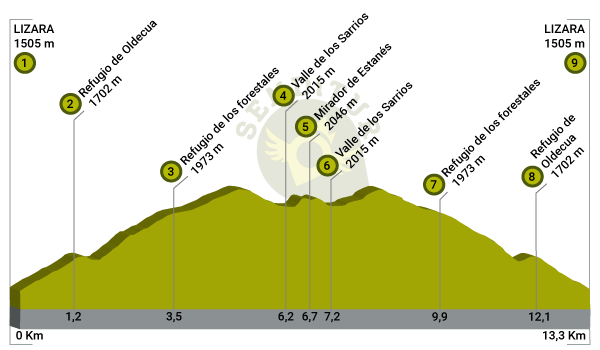
| 1-Lizara car park | 0:00h | 1505m | 0Km | 30T 693630 4737225 |
| 2-Oldecua mountain hut | 0:35h | 1702m | 1.2Km | 30T 693967 4738121 |
| 3-Foresters' Montain Hut | 1:40h | 1973m | 3.5Km | 30T 694929 4739502 |
| 4-Sarrios Valley | 3:15h | 2015m | 6.2Km | 30T 696990 4740032 |
| 5-Estanés viewpoint | 3:40h | 2046m | 6.7Km | 30T 696930 4740369 |
| 6-Sarrios Valley | 3:55h | 2015m | 6.9Km | 30T 696990 4740032 |
| 7-Foresters' Montain Hut | 5:00h | 1973m | 9.9Km | 30T 694929 4739502 |
| 8-Oldecua mountain hut | 5:20h | 1702m | 12.1Km | 30T 693967 4738121 |
| 9-Lizara car park | 5:36h | 1505m | 13.3Km | 30T 693630 4737225 |
Coordinates UTM Datum WGS84

![]() Slope: 1670m
Slope: 1670m
![]() Slope +: 835m
Slope +: 835m
![]() Slope -: 835m
Slope -: 835m
![]() Maximum altitude: 2115m
Maximum altitude: 2115m
![]() Minimum altitude: 1505m
Minimum altitude: 1505m

This sketch of the route is not made to scale nor does it contain all the information relating to the area, it is merely indicative.

This schematic with the path is approximate and has been created from the derived cartographic base © Instituto Geográfico Nacional "Cuadrante 114-2 1:25.000".
Senditur has manipulated the tracks to correct the aberrant points that may exist, caused by problems with the reception of the GPS signal. In any case the tracks are always approximate. SENDITUR encourages you to use the new technologies within your reach, using them as support and consultation in your activity, not basing the realization and orientation of the same only and exclusively on them, since they may see their functioning altered by very diverse causes, not functioning correctly and their indications may not be precise.
¿Did you know that...
The Lizara mountain hut is the starting point and transit point for great hiking and trekking routes, such as the GR 11 or the Pyrenean Path, not forgetting the Camille Path, among other activities, or ascents of mythical mountains such as the Bisaurín. In winter you can also go cross-country skiing and snowshoeing.
Don't miss out...
A visit to the nearby towns of Jasa and Aragües del Puerto, villages with well-kept and typical traditional architecture that invite you to stroll through their streets while you discover their hidden corners.
From the commitment of SENDITUR with Nature and the respect to the balance of the environment, SENDITUR urges you to travel in a responsible way, with low environmental impact and respecting at all times the Natural, Cultural and Social environment wherever you go.
Besides sharing with all of us your experience on the route we would be grateful if you could write to us to inform us of any erroneous or outdated information you may have found, or simply to let us know what you think at info@senditur.com Thank you.
This route has been carried out in the field by SENDITUR on 29-07-2021. The route may vary greatly depending on the time of year, weather conditions and terrain, as well as the actions of third parties and the evolution suffered in the natural environment where it is located. All opinions, advice and/or assessments made by SENDITUR in their descriptions are for guidance only and are subject to and/or refer to the specific conditions of the specific day of the route, referring to that specific day, taken from trained people, with the appropriate experience and with a high level of physical and technical preparation as a reference, as well as correctly equipped.
All the times are approximate and take an orientative character, the stops have not been taken into account, no matter how small they are. All the information related to the route, texts, images, videos, maps, diagrams, tracks, towns, and places of tourist interest are published as a guide, and may not coincide with the current state of each place. Before undertaking any activity, assess your technical knowledge, your physical condition, find out about the weather and the variations that the route may undergo, equip yourself correctly, be prudent and responsible at all times, and do not exceed your capabilities. SENDITUR is not responsible for any misuse or inappropriate use of the comprehensive guides of its routes and/or publications as well as its electronic guides, nor for any variations in their descriptions for the aforementioned reasons, and recommends that everyone be responsible and prudent in carrying out the activity. We also encourage you to read books and specialised guides to complement the information described above.
Continue watching …