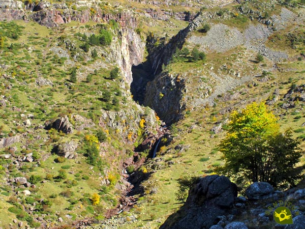
Surrounded by imposing mountains and steep ravines, which pour their waters into the newborn river Aragon Subordan in the heart of the Natural Park of the Western Valleys and belonging to the municipality of Ansó, awaits us the majestic setting of Tuertas Waters. History and nature merge in this place marked by the whimsical course of the river as it flows through this wide plateau nestled between mountains, chosen by the ancients to leave us enigmatic evidence of their presence here.

The route with only 6.8 km starts from the parking of the Ravine of the Barcal to go up the valley of Tuertas Waters to which to its natural value must be added that of having one of the greater concentrations of megalithic constructions of all the peninsula. The Mallo Blanco breaks with the peaceful landscape of the valley through which the Aragon Subordan River flows, trying to escape from the mountains that saw its birth. We gain height as we contemplate closer and closer The Jump, a deep gorge that cuts the side of the mountain and through which the river rushes from the top of the plain towards which we are heading. As we pass by, we almost do not notice it, either because of the distance that separates us from them or because we need to know how to distinguish some of these mysterious constructions. We will leave behind different megalithic mounds that are over 4500 years old, true jewels of history.

The hut of Achar of Tuertas Waters receives us after a not little demanding ascent following the steps of the GR 11 in its advance by this zone of The Pyrenees. The extensive high plateau of Tuertas Waters extends majestically before us, allowing us to contemplate the twisted riverbed as it passes by. Many people have passed through here, livestock farmers, traders, bandits and now mountaineers and hikers who never cease to be surprised by the landscape around them. However, there are few people who have such a longstanding record of their presence in these lands as the millenary stones of the Dolmen of Achar of Tuertas Waters bear witness to. Once we have enjoyed the magical harmony that this place transmits, we will take the road back following our steps to return to the parking lot, from where we set off on this interesting route.

Legend has it that in the depths of Achar's dolmen, for over six thousand winters, there has been a brave little elf whose main mission is to safeguard the entrance to the Tuertas Waters Valley. To do so without being seen, it observes those who approach the valley and also those who are already there to decide if they are worthy of enjoying such a beautiful corner and to expel, in a thousand ingenious ways, those who for some reason are not.
To get to Tuertas Waters we must first go to Hecho and Siresa from Puente la Reina de Jaca, on the road that connects Pamplona with Jaca and which can also be reached from Huesca. Or from Ansó following the road that links the valleys of Hecho and Ansó with the Roncal valley in Navarre. Once in Hecho we will have to head towards Siresa and continue without deviating from the road that passes through this town up the course of the Aragon Subordan River, crossing the narrow Ravine of the Mouth of Hell. Without leaving the road we will arrive at the Oza Forest where we will continue without deviations the battered road that little by little is becoming an ample earth track that goes up all the valley taking us until the zone of parking located where the authorization for the circulation of vehicles finalizes and where we will be able to park ours and to begin the route.
A good route to get you used to hiking and mountaineering with our dog. Without a great physical demand will be able to enjoy the environment that surrounds it, attention with the stones in the zone of the footpath is easy that it is possible to be damaged the legs.
Although water is usually not going to be lacking on this route is not wrong to bring along with your food ration another water just in case. Watch out for the force with which the river flows down before you are tempted to let him enjoy a refreshing swim.
The cattle, cows, horses and others, are the owners of this area and no doubt we will meet them repeatedly, there are even areas where it is forbidden to go with our dogs and in the others it is a rule of the park to take them tied up at all times so that they do not disturb the other animals. On our return it is advisable to take a look at them to rule out possible parasites that are very common in the livestock areas.
The torrent of water that flows through the Barcal ravine marks the end point of the permit for the circulation of vehicles on the track that goes up the valley.

Right there, from the parking lot (0h 00min) that is located in this place, the route starts that will take us to the extensive plain of Tuertas Waters.

Thanks to a small bridge we will be able to cross without getting wet the water flow that goes down to the river.

The wide dirt track we came here on continues to guide us to our destination. We go up the valley gaining height calmly but without pause.

The landscape that surrounds us makes this long stretch of path that awaits us much more enjoyable.

Soon we will begin to contemplate the head of the valley where the water jumps, escaping from it.

After a while of calm ascent we will find another water torrent, normally dry, but that in certain times of the year can descend with enough water.

We arrived at the moment of choosing between following the course of the track that winds up, ascending the slope of the mountain. Or do it by the path that shortens the route in exchange for a greater effort.

The stony trail coincides with the route followed by the GR 11 as it passes through this area.

We will soon find ourselves back on the path that offers us its long and more tranquil itinerary.

On the contrary, our trail, after crossing it, continues with its convoluted and demanding course. The typical milestones and marks of the GR serve as a reference to follow.

There are several trails that cross this hillside, in search for the most comfortable route for each person.

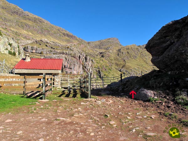
Almost at the top we'll have to go through a gate that stops the cattle. We only have a short stretch of ascent left that will take us back to the path just as it reaches its end.

The hut of Tuertas Waters and its enclosure marks the closeness of our objective.

Now we will only have to decide whether to descend directly or continue for a while the route of the GR to go up the plain, without having to overcome hidden channels or waterlogged areas.

Along the GR we will have several possibilities to say goodbye to it and to descend to Tuertas Waters (1h 05min). If this has been the chosen option, for our return it is better to do it following the same route until the proximities of the cabin.

There we can return to the plain to approach another of the magical corners of this place. An almost unappreciable trail borders the hill that marks out the hut leading us without any problem to the Achar Dolmen, Tuertas Waters (1h 10min).

After dedicating the time that this beautiful place of the Pyrenees of Huesca deserves we will return desandando the walked thing until the parking (1h 50min), where we initiated this route of hiking.
The route we follow on the Agua Tuerta plateau will mark the final distance.
Without a doubt, it is worth dedicating enough time to this natural spot to enjoy the spectacular landscape it offers together with the calm and tranquillity it transmits and not to go up and down in a hurry.
In periods when snow and ice are not the protagonists, besides simplifying notably the difficulty of the route, they will allow us to enjoy one of the beautiful corners that the Valles Occidentales Natural Park treasures. The intense colours of spring and autumn give added value to the curious landscape that awaits us in Tuertas Waters, covered in snow in winter. The water is one of the protagonists of this route and its presence or not also alters the beauty of the place and the difficulty to access it, since there are several streams that pass by.
No matter how simple or easy a route may seem to us, it is always advisable to take a minimum of equipment in addition to suitable footwear and clothing, in this case of hiking. A windbreaker, waterproof or warm clothing that gives us some margin if we need it, some food and water in addition to the usual protection against the sun, a small first aid kit and the necessary equipment that together with the information of the route will help us to orientate ourselves in case of doubt or need, are some of the companions that should never be missing. Consult our list of material and equipment for hiking. Read more.
Physical
The unevenness we will have to face is largely concentrated in the vicinity of Tuertas Waters. There we will face hard ramps that if we take them with patience would not have to cause us major complications. Given the total distance and having enough time to take it easy, we will be facing a route that will not require us a great physical preparation.
Severity of the environment
Under normal conditions, in summer, and as long as we do not leave the route as planned, we should not have any complications, always bearing in mind that the natural environment around us is uncontrollable and changing. The trail that goes up to Tuertas Waters is a little broken, also crosses a threatening scree zone while gaining height, this area along with the short stretches of track in which we cross the streams, in many cases without flow, are where we will be more exposed although we do not seem so. Be careful if you go through the Tuertas Waters meadow, it is a labyrinth of hidden watercourses that feed the main river.
Orientation
To get there and back we should not have any major difficulties since first the wide track and then the marked path will guide us perfectly. The marks of the GR-11, which we will coincide with in the area of Tuertas Waters, should not confuse us, although in the area of the trail they will be of great help in guiding us through the network of trails that cross the stony slope. Once in Tuertas Waters we will only find the marks of the GR 11 that crosses the side of the valley, so it is important to be aware of the possibility of fog. We will have to have clear in advance where the dolmen is located if we want to go see it.
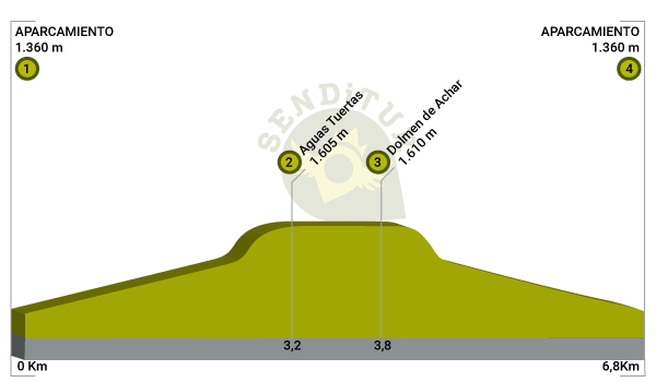
| 1-Parking | 0:00h | 1360m | 0Km | 30T 691579 4745834 |
| 2-Tuertas Waters | 1:05h | 1605m | 3.2Km | 30T 694074 4744408 |
| 3-Dolmen of Achar, Tuertas Waters | 1:10h | 1610m | 3.8Km | 30T 693897 4744909 |
| 4-Parking | 1:50h | 1360m | 6.8Km | 30T 691579 4745834 |
Coordinates UTM Datum WGS84

![]() Slope: 576m
Slope: 576m
![]() Slope +: 288m
Slope +: 288m
![]() Slope -: 288m
Slope -: 288m
![]() Maximum altitude: 1610m
Maximum altitude: 1610m
![]() Minimum altitude: 1360m
Minimum altitude: 1360m

This sketch of the route is not made to scale nor does it contain all the information relating to the area, it is merely indicative.

This schematic with the path is approximate and has been created from the derived cartographic base © Instituto Geográfico Nacional "Cuadrante 118-4 y 144-2, 1:25.000"
Senditur has manipulated the tracks to correct the aberrant points that may exist, caused by problems with the reception of the GPS signal. In any case the tracks are always approximate. SENDITUR encourages you to use the new technologies within your reach, using them as support and consultation in your activity, not basing the realization and orientation of the same only and exclusively on them, since they may see their functioning altered by very diverse causes, not functioning correctly and their indications may not be precise.
¿Did you know that...
The megalithic heritage of the province of Huesca is one of the most important and extensive in the entire Iberian Peninsula. These rupestrian sanctuaries form an important part of the prehistory that has reached our days, contributing its enigmatic and in many cases unknown story to the fabulous landscape that surrounds them.
Don't miss out...
The Dolmen of the Pass of Escalé is about 2 km away at the bottom of the Tuertas Waters Valley, at the crossroads with the path that leads to France. It is an interesting megalith that stands out for its unique interior structure, more complex, which makes it almost unique in the Pyrenees.
From the commitment of SENDITUR with Nature and the respect to the balance of the environment, SENDITUR urges you to travel in a responsible way, with low environmental impact and respecting at all times the Natural, Cultural and Social environment wherever you go.
Besides sharing with all of us your experience on the route we would be grateful if you could write to us to inform us of any erroneous or outdated information you may have found, or simply to let us know what you think at Thank you.
This route has been carried out in the field by SENDITUR on 27-08-2016. The route may vary greatly depending on the time of year, weather conditions and terrain, as well as the actions of third parties and the evolution suffered in the natural environment where it is located. All opinions, advice and/or assessments made by SENDITUR in their descriptions are for guidance only and are subject to and/or refer to the specific conditions of the specific day of the route, referring to that specific day, taken from trained people, with the appropriate experience and with a high level of physical and technical preparation as a reference, as well as correctly equipped.
All the times are approximate and take an orientative character, the stops have not been taken into account, no matter how small they are. All the information related to the route, texts, images, videos, maps, diagrams, tracks, towns, and places of tourist interest are published as a guide, and may not coincide with the current state of each place. Before undertaking any activity, assess your technical knowledge, your physical condition, find out about the weather and the variations that the route may undergo, equip yourself correctly, be prudent and responsible at all times, and do not exceed your capabilities. SENDITUR is not responsible for any misuse or inappropriate use of the comprehensive guides of its routes and/or publications as well as its electronic guides, nor for any variations in their descriptions for the aforementioned reasons, and recommends that everyone be responsible and prudent in carrying out the activity. We also encourage you to read books and specialised guides to complement the information described above.
Continue watching …