Welcome to SENDITUR.COM · paths · routes · tourism


Circular Route through the Itxina Massif
Areatza, Vizcaya - Bizkaia![]()
![]()
![]()
![]()
![]() (1)
(1)
A natural site inhabited by mythological beings
![]() Difficulty-Moderate
Difficulty-Moderate
![]() 3:25 h.
3:25 h.
![]() 9.4 km.
9.4 km.
Areatza, Vizcaya - Bizkaia![]()
![]()
![]()
![]()
![]() (1)
(1)
A natural site inhabited by mythological beings
![]() Difficulty-Moderate
Difficulty-Moderate
![]() 3:25 h.
3:25 h.
![]() 9.4 km.
9.4 km.
The Gorbeia Natural Park brings together great natural and scenic values, mythical mountains such as the Gorbeia, whose summit is today visited by many mountaineers, competes with natural resources as important as those hidden in the Itxina Massif. A surprising labyrinth of chasms and dolines dotted with caves and traditional legends of Basque mythology.

The circular route through the Itxina Massif takes us along its 9.4 km to visit some of its secret corners, some corners that treasure beauty and mysticism almost equally. From Pagomakurre this route begins putting course directly towards one of the emblematic places that Itxina hoards. An ascent through the leafy forest that populates the slopes of the mountains of the massif that leaves us at the foot of the entrance door to Itxina, the Eye of Atxular. After passing through this natural door we will enter an almost magical world of incredible landscapes and corners. Places as impressive as the cave of Supelegor, in whose interior some of the best known mythological beings in the Basque Country meet. But Itxina hides many more treasures only reserved for intrepid hikers with enough experience, such as the Great Rift or the many chasms and dolines that are gathered in this natural spot.

The route also takes us to visit some of the places where man has left his mark on Itxina, a mark in the form of traditional shepherd's huts such as the Hut of Lexardi, where the last shepherd of Itxina made his rich cheeses. But it also gives us the opportunity to get close to the colossal neveras that used to supply the city of Bilbao with its precious ice. Kargaleku is another gateway to the Itxina Massif and in our case it is the passage that we will use to leave this surprising place and enter another place that is no less surprising than the Campas of Arraba. Under the attentive look of the Gorbeia we cross the green plains of Arraba to undertake the return that has to take us until Pagomakurre, where we will put end to this adventure by Itxina and its mysteries.

There are countless legends surrounding Itxina, the Mari and the Basajuan, most of which are linked to the legend of the brave bandits who used the cracks and caves of Itxina as an unbeatable place to hide their treasures. Legend has it that when the Eye of Atxular was only a small cave in the vertical mountain cliffs, inside was a terrifying beast with bright fire-red eyes. This beast guarded a great treasure accumulated by a famous bandit during his many years of misdeeds. It is said that this bandit was killed in one of his raids there by Urkiola and that when the locals found out that the bandit was hiding his treasures here, they rushed to the mountain to get them. But they did not count on the beast that was guarding them and that, seeing itself preyed upon by the tumult that was coming for the treasure, it broke the interior of the mountain with its claws, escaping together with the treasure from the other side of what until now was the cave of Atxular.
To get to Pagomakurre we must first go to the town of Areatza, which we will find on the old N-240 road linking Bilbao and Vitoria, or to the town of Orozko. And it is in the highway that unites these two populations where we will find the beginning of the asphalted track that ascends until Pagomakurre. Once there we will have several zones where we will be able to park our vehicle to begin with the route.
The regulations of the Gorbeia Natural Park allow dogs to enter, but only if they are tied up, which is also advisable for their safety. For the rest the route should not suppose great complications to him if it is in the habit of accompanying us in our escapades.
There are several water points but they do not guarantee that we have water for our friend so we will have to take him his corresponding ration along with some food so that he can recover the spent energies.
Pay close attention to the terrain we are walking on, it is possible that you could get hurt. It is quite usual to meet with the cattle that graze in the area, although they are usually concentrated in the Campas of Arraba and its surroundings.
The parking of Pagomakurre (0h 00min) is the departure point for a good number of the routes that cross the Natural Park of the Gorbeia and also it is it for ours.

At the beginning of the parking area, next to the information sign of the park, we will find the passage that will allow us to save the fence that delimits this recreation area.

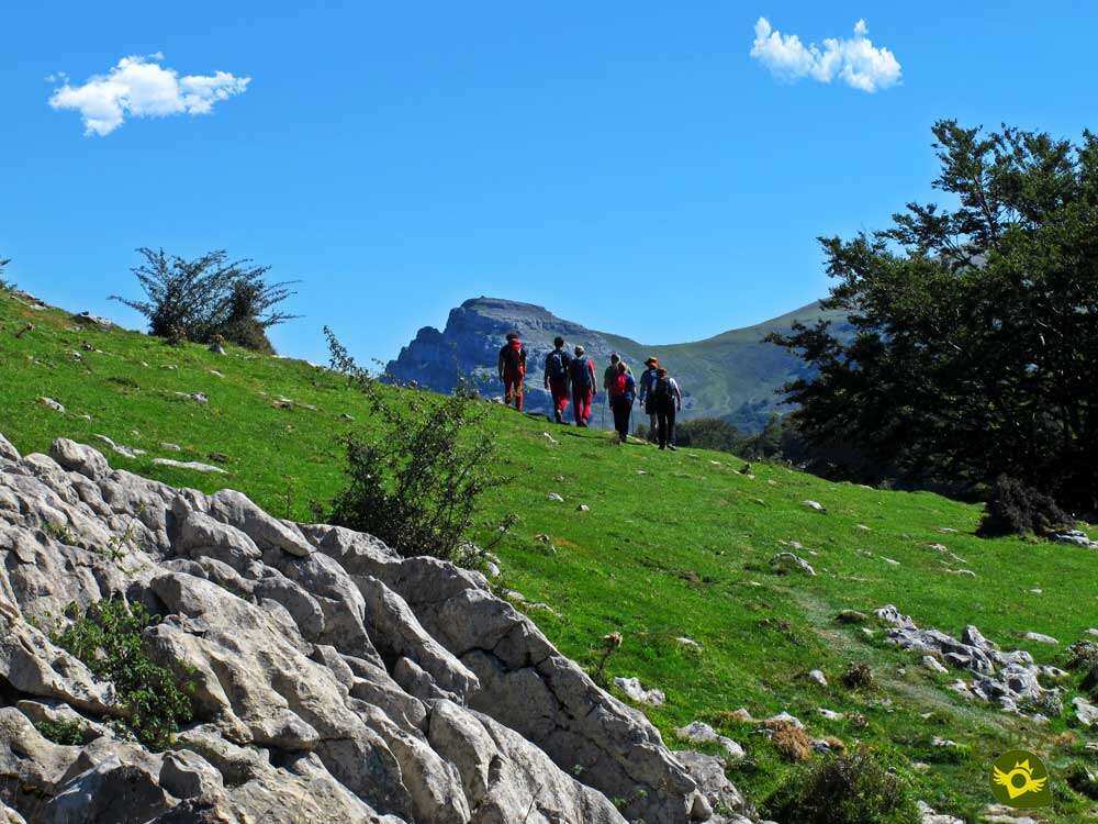
We then began to gain altitude gently, walking the picnic area. Soon the thick grove allows us to contemplate, even for an instant, the abrupt silhouette of Itxina.

This part of the tour with hardly any inclination takes us through the forest by making us cross several bridges over the streams that descend from the mountain. Depending on the time of year, these streams may be completely dry.

Little by little, the unevenness begins to become much more evident as we approach the limits of the forest we are crossing.

The ground we are walking on is beginning to give us the first signs of what lies ahead. After a good while gaining height, the trees begin to give way.

Our marked trail practically disappears when it comes across a fence, at which point the route turns radically to our left to face the hard final climb of this section.

The Eye of Atxular is shown before our eyes, signposted by the corridor without vegetation that ascends to it.

The trail has completely disappeared under the green meadows we are walking through, which forces us to be vigilant in order to locate the entrance to the final stretch of the ascent.

After turning off for a few metres to our left, and when we reach the edge of the trees in front of us, the route changes direction again abruptly to lead us definitively to the Eye of Atxular.

Once again, a decomposed trail leads us surrounded by vegetation, making us gain height with effort.

Little by little the vegetation gives way again leaving us at the foot of the magnificent Eye of Atxular (1h 00min), gateway to the mysterious Itxina.

We cross the eye and after taking a well deserved break enjoying this colossal place we start the itinerary through Itxina bordering the first of the many dolines that we will find.

On the other side, we will find the detour to the Supelegor cave (1h 05min).
Here we have the highly recommended option of approaching this mystical place, one of the best known of the Itxina Massif.

To do this we will leave the path to which we will then return to begin our descent back into the forest.

From now on we will have to be very attentive as it is quite easy to get off the right track.

The absence of marks leaves us at the mercy of the different stone landmarks that serve as a guide.

The path has slowly separated us from the rocky wall where the Eye of Atxular sits, and shortly after leaving the forest it changes course again.

We continued descending with our eyes fixed on the rocky outcrop we had crossed before, but before approaching it, we were surprised by the Itxulegor cave.

We leave Itxulegor behind us, to continue approaching the increasingly visible cave of Supelegor (1h 15min).

Once there, we will take the opportunity to go deep into its depths in the hope of finding some water in the lake that awaits us inside.
Once we have enjoyed this mysterious place full of legends we will retrace our steps to the crossroads that brought us here, not before being tempted to approach the Great Rift, something reserved for people who know the place well since there is no clear path and it is very easy to get into unnecessary trouble.

Once at the crossroads, we take the trodden path that will lead us to the hut of Lexardi. A trail that, although it can be followed without major complications, does force us to be attentive.

The fact is that the terrain we are travelling through is plagued by deep chasms and wide dolines so it is not advisable to leave the path we are following.

This part of the route is a continuous up and down, but without the hard ramps we have left behind. We alternate the wooded areas with other clearer ones that allow us to contemplate the spectacular landscape that surrounds us.

From time to time we have to come across some red markers that formerly marked the route and that together with the milestones serve as a reference to follow.

Shortly before reaching our next goal, we will have to face a new ascent that will take us away from the limits of the forest we were going through.

After that, the Lexardi hut (2h 00min) awaits us, a perfect place to take a well-deserved rest.
After the rest, we continue our journey, leaving a nearby fountain on our right, which is located in this spot.

Once again we see ourselves gaining height, not without effort, surrounded by the calcareous rocks that characterize the Itxina Massif.

An ascent that with each step we take lets us intuit the figure of the lord of these lands, the Gorbeia.

Once again we will see ourselves riding a kind of roller coaster that makes us go up and down, forcing us to face the occasional hard slope.

The Gorbeia is becoming more and more the protagonist of the landscape we are contemplating. As long as, of course, the vegetation does not come between it and us.

The trail does not give us a second of respite, forcing us to overcome harsh areas where we must pay attention to avoid problems, especially if they are wet, sections that continue to surround us with their particular beauty and are part of the uniqueness of the Itxina Massif.

Shortly before we reach the next halfway point on the route we will have to face a tough climb back up. Once again, the forest surrounds us, giving us the opportunity to say goodbye to it.

A little further on, where this stretch of ascent ends, the Kargaleku pass (2h 30min) awaits us, where we will leave Itxina.
Here, as it happened to us in Supelegor, those who know the area and still have some energy left can approach some old neveras, of singular size, which were in use until relatively few years ago.

The rest of us start the descent through the Kargaleku pass, in search of the green Campas of Arraba.

The trail quickly leaves us at the gates of this wide high plateau, but we still have a small distance to go before we can definitely reach this peaceful place.

As in the whole tour, it is important to be attentive so as not to take the wrong path that takes us away from the right course.

Following almost in parallel the limits of the mountains that conform the Massif of Itxina we will arrive at the refuge, one of the two existing ones, that waits for us in the Campas of Arraba (2h 40min).
From practically the same door of the refuge begins the path that will take us back to the starting point of this beautiful circular route.

On our right we are joined by another path that leads here from the second refuge of the Campas of Arraba.

A long journey awaits us, following at all times the conditioned track that ascends from Pagomakurre.

A section of the route that, after having covered such remarkable landscapes, becomes somewhat heavier than it really is.

After a while the parking of Pagomakurre (3h 25min) is presented to us, parking that we will cross of side to side to give by finalized this interesting route by the Massif of Itxina, in the Natural Park of the Gorbeia.
 Distance. 9.4Km
The labyrinthine nature of some sections of the route may cause us to cover more distance than expected.
 Time. 3:25h
Without a doubt this figure can vary a lot, not only because of the detours we can take, but also because of the state of the land where the route runs.
 Time of year
The autumn can be for his special colorful a great period to visit Itxina, but if we want to see for example with water the lake of Supelegor the beginning of the spring is in the habit of being the best period since the accesses will be more passable that in the winter. The fog or the bad weather are not good companions of route in Itxina.
 Required equipment
Although as a general rule the headlamp, with its corresponding charged batteries, and the GPS with the track of the route, should always accompany us in our backpack, here they are more necessary than ever since the first one will allow us to go into Supelegor and the second one will serve as support in case of need. The irregular and slippery terrain makes it very advisable to wear a boot with a good sole that will undoubtedly give us more security and protection. It is also important to wear some warm clothes, even in summer. Consult our list of material and equipment for hiking. Read more.
 Difficulty. Moderated
Physical
The distance added to the inclination of some parts of the route force us to be in good physical shape to avoid suffering more than necessary. Even so, on the most demanding ramps it is advisable to take it easy. We must also take into account the tiredness that can create stress that causes us to cross some area, especially if it is slippery.
Severity of the environment
It is very important not to leave the trails due to the large number of chasms and dolines in the area, which in many cases are practically covered by the vegetation of the place. The stones can be very slippery so you have to pay attention as you go. Apart from this, and except for some areas more exposed to landslides, we should not have any more complications.
Orientation
Without marks to guide us and with areas where the path practically disappears or there are several trails, in most cases only the typical stone landmarks will serve as a reference. The problem is in differentiating which is the correct landmark from those we will find in some points. So it is very important not only to prepare the route in advance, but also to take with us the necessary equipment to guide us in case of doubt or need, obviously knowing how to use it.
 |
 |
 |
 |
 |
| 1-Pagomakurre | 0:00h | 876m | 0Km | 30T 516888 4769624 |
| 2-Eye of Atxular | 1:00h | 1108m | 1.9Km | 30T 515623 4769231 |
| 3-Detour to Supelegor | 1:05h | 1090m | 2Km | 30T 515540 4769155 |
| 4-Cave of Supelegor | 1:15h | 1003m | 2.7Km | 30T 515051 4769239 |
| 5-Detour to Supelegor | 1:35h | 1090m | 3.4Km | 30T 515540 4769155 |
| 6-Hut of Lexardi | 2:00h | 1115m | 4.5Km | 30T 515686 4768273 |
| 7-Pass of Kargaleku | 2:30h | 1116m | 5.7Km | 30T 515993 4767293 |
| 8-Campas of Arraba | 2:40h | 1075m | 6.2Km | 30T 516406 4767333 |
| 9-Pagomakurre | 3:25h | 876m | 9.4Km | 30T 516888 4769624 |
Coordinates UTM Datum WGS84

 Slope: 1028m
 Slope +: 514m
 Slope -: 514m
 Maximum altitude: 1128m
 Minimum altitude: 876m

This sketch of the route is not made to scale nor does it contain all the information relating to the area, it is merely indicative.

![]()
This schematic with the path is approximate and has been created from the derived cartographic base © Instituto Geográfico Nacional "Cuadrante 087-1 y 087-3, 25.000"
Senditur has manipulated the tracks to correct the aberrant points that may exist, caused by problems with the reception of the GPS signal. In any case the tracks are always approximate. SENDITUR encourages you to use the new technologies within your reach, using them as support and consultation in your activity, not basing the realization and orientation of the same only and exclusively on them, since they may see their functioning altered by very diverse causes, not functioning correctly and their indications may not be precise.


Recorrer el macizo de Itxina es toda una experiencia. Para mí es uno de los mejores sitios para hacer senderismo y disfrutar de la naturaleza, lo recomiendo.


Sanctuary of the Santos Antonios, one of the oldest and most venerated in Vizcaya


Home of the Patron Saint of Alava, a jewel of Alava's Romanesque style.


Find out what to see in...
¿Did you know that...
The Itxina Massif, or rather, its interior is made up of kilometres of underground galleries and chasms hundreds of metres deep, making it an exceptional place for the practice of speleology.
Don't miss out...
The spectacular neveras near Kargaleku. It is worthwhile to go over the stretch of steep ascent that leads to them in order to be surprised by the dimensions that some of these neveras may reach.


From the commitment of SENDITUR with Nature and the respect to the balance of the environment, SENDITUR urges you to travel in a responsible way, with low environmental impact and respecting at all times the Natural, Cultural and Social environment wherever you go.

Besides sharing with all of us your experience on the route we would be grateful if you could write to us to inform us of any erroneous or outdated information you may have found, or simply to let us know what you think at Thank you.
This route has been carried out in the field by SENDITUR on 23-09-2018. The route may vary greatly depending on the time of year, weather conditions and terrain, as well as the actions of third parties and the evolution suffered in the natural environment where it is located. All opinions, advice and/or assessments made by SENDITUR in their descriptions are for guidance only and are subject to and/or refer to the specific conditions of the specific day of the route, referring to that specific day, taken from trained people, with the appropriate experience and with a high level of physical and technical preparation as a reference, as well as correctly equipped.
All the times are approximate and take an orientative character, the stops have not been taken into account, no matter how small they are. All the information related to the route, texts, images, videos, maps, diagrams, tracks, towns, and places of tourist interest are published as a guide, and may not coincide with the current state of each place. Before undertaking any activity, assess your technical knowledge, your physical condition, find out about the weather and the variations that the route may undergo, equip yourself correctly, be prudent and responsible at all times, and do not exceed your capabilities. SENDITUR is not responsible for any misuse or inappropriate use of the comprehensive guides of its routes and/or publications as well as its electronic guides, nor for any variations in their descriptions for the aforementioned reasons, and recommends that everyone be responsible and prudent in carrying out the activity. We also encourage you to read books and specialised guides to complement the information described above.
Continue watching …


