Welcome to SENDITUR.COM · paths · routes · tourism


GR 38 Route of the wine and of the fish Section 6 Durango-Gernika
Durango, Vizcaya - Bizkaia![]()
![]()
![]()
![]()
![]() (0)
(0)
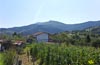
A landscape of green mountains dotted with large farmhouses
![]() Difficulty-Remarkable
Difficulty-Remarkable
![]() 7:50 h.
7:50 h.
![]() 28 km.
28 km.
Durango, Vizcaya - Bizkaia![]()
![]()
![]()
![]()
![]() (0)
(0)
A landscape of green mountains dotted with large farmhouses
![]() Difficulty-Remarkable
Difficulty-Remarkable
![]() 7:50 h.
7:50 h.
![]() 28 km.
28 km.
The valleys and mountains that separate the towns of Durango and Gernika are the incomparable setting through which the GR 38 Route of the wine and of the fish runs in this area of Bizkaia. Green pastures, rounded mountains populated with dense forests, together with the well-tended baserris and villages we will pass through, form the magnificent landscape that will surround us along this route.

The stage 6 Durango-Gernika along its 28 km will discover us hidden corners full of mysticism and traditions. Durango and its splendid monumental ensemble refuse to let us leave, showing us part of its character. Iurreta and its church of San Miguel precede the untiring ascent that we have ahead of us in which the Route through the Hermitages will accompany us in part of the journey. It is the hermitages of San Martín, San Juan and Santa Catalina that we will find in this first part of the stage. At all times we are surrounded by the unique Basque mountains dotted with small towns like Mauma.

There are several routes that go through this area of Bizkaia, the GR 229 or the GR 98 Tour of Urdaibai will accompany us in part of our itinerary in which we will have the opportunity to detour to follow some of the variants of the GR 38 that bring us closer to the coastal towns of Lekeitio and Ondarroa. We jump from valley to valley under the attentive gaze of the Balcony of Bizkaia to reach Albiz, to have our first contact with the landscape that surrounds the town of Gernika a little further on. But first it is Mendata that welcomes us before we start the long descent that will definitely bring us closer to historic Gernika, the final point of this stage of the Wine and Fish Route.

Given the physically demanding nature of the route, it is not a bad idea to have the possibility of shortening the stage. We have the towns of Albiz and Mendata, which allow us to have them as an alternative if it is necessary to put a stop and go on the stage.
Both the AP-8 motorway and the N-634 road pass through Durango, connecting it with Bilbao and San Sebastian, among other towns. We can also reach Durango from Vitoria, passing through Urkiola first, and from Mondragon. Durango also has an Euskotren station and daily services of several bus lines that communicate it with the nearby towns as well as with the capital.
Intense route that requires a very good physical preparation of our friend, both for the distance and for the unevenness to overcome. The kilometres of asphalt can also make a dent in our friend.
Be aware of the distances between the different points where we can find water, and pay attention to the long stretches in the company of the always dangerous vehicle traffic.
Loose dogs and cattle in some areas of the route will force us not to lower our guard to avoid problems.
We take as a starting point in Durango (0h 00min), for this stage of the GR, the Ezkurdi Square.

From there we will take the itinerary that marks the street that in the previous stage brought us to this square.

We continue our journey through the streets of Durango as we finished the previous stage, with no signs to help us verify the correct route.

Fortunately, we will not have to make a detour until we reach the height of the river that bathes the town.

As soon as you cross it, the itinerary turns sharply to the right, following the street that comes out to that hand.

A little further on this new street forks into two, with the street on the right again being the right choice.

This street takes us to the mouth of a tunnel that will allow us to cross the national road.

On the other side, the beautiful square of Iurreta (0h 15min) awaits us, which houses the church of San Miguel and the town hall, among other buildings.

And it is between these two illustrious buildings that we must continue our journey.
As soon as we pass by them we find the first signposting of the GR 38, which together with the marks of the Route by the Hermitages, will facilitate our work in part.

We bordered the church of San Miguel to go in search of the road we will have to follow.

When we reach it, we set a course towards the tunnel that will allow us to cross the nearby highway.

As soon as we do so, we will find to our right the beginning of the hard ascent that awaits us.

We go up this paved road without abandoning it at the different crossroads we pass through and which give access to the houses that populate this area.

After a while, the paved road reaches its end leaving us at the gates of the small hermitage of San Martín.

A steep trail will be in charge of making us gain height not without effort. This part of the route covered with vegetation forces us to be attentive to find the few marks of the GR 38 that mark the route.

Fortunately, in most cases the footprint of our trail and the vegetation that almost covers the other options will serve as a reference in case of doubt.

After a while the slope seems to give us a break as we reach the vicinity of a new farmhouse that we left on our right.

That truce that the slope had granted us ends earlier than desired, forcing us once again to make a greater effort to move forward.

The wide trail we were following comes to an end when we come across a conditioned path through which we will continue to climb.

Quickly this path leads us to the meeting of the road by which we will continue to gain height.

As if it were an oasis, the hermitage of San Juan tempts us with its welcoming surroundings.

After taking a break and recovering our energy we continue the course of the road that leads us to a new intersection. There is the Santa Catalina hermitage that welcomes us, preceding the hard climb that awaits us.

We started to gain height again quickly, following the steep asphalt track that goes up the mountain. A track that we should not abandon in the few crossroads that come out to our encounter.

At the end of the track a water well awaits us and the beginning of the path that will lead us from now on. The effort involved in travelling this part of the Wine and Fish Route is partly rewarded by the lush forest that surrounds us.

For the moment we are moving forward without too many complications and with the invaluable help of the GR 38 marks at the crossroads we pass.

Marks that we share with those of the GR 229 whose route will accompany us for some time. Once again we see ourselves walking another conditioned path that brings us closer to a small shelter.

Here we will say goodbye to the asphalt again as we cross this recreational area.

The path continues to make us gain height, although not as demanding as in previous sections. Soon the forest is giving way, forced by the logging activity in this area.

This activity, besides leaving us rocked by the relentless sun, makes us meet the different paths they build to access every corner of the mountain.

Paths that in most cases do not have signs of the GR 38 as they did not exist previously or the tree where it was located has disappeared. Machines and mud have left some areas quite badly damaged.

We began to lose altitude in the hope of leaving this part of the route behind as soon as possible.

The descent takes us to a new junction where we will say goodbye to the GR 229 company and enter another wooded area.

Here, as in the previous sections, it is easy to find some mud that complicates our day. Another lonely baserri comes out in our path marking the beginning of another stretch on the asphalt.

We began to gain height once again as we followed the course of the paved road that started from the farmhouse.

In front of us we can already see the first houses of our next target. The small town of Mauma (3h 10min) invites us to make a stop on the way before continuing with the itinerary we are following.
We continue to ascend following the course marked out by the cemented track from Mauma.

Once again, industrial activity linked to wood is once again on our path. A path that, if it had rained, could become practically impracticable.

The deforestation that the area has suffered, linked to the mud that we can find, can make this part of the route quite complicated.

Luckily the forest is back in the spotlight, at least for the time being. The GR marks are still a great help to us in following the right course.

Even inside the thick forest we are walking through, if it has rained, the mud and water may force us to look for alternative steps to the path we are following.

There will be quite a few junctions that we will go through, although they are usually well signposted.

Crossroads where the vegetation also does its bit, while we join the route of the GR 98, also known as the Tour of Urdaibai, and with which we will henceforth share the journey on several occasions.

The path that once ran through these forests has been reduced to a trail surrounded by vegetation.

This entertaining area comes to an end when we come across the cement track where we will continue and where we will find the detour of the GR 38 variants (4h 10min) which if followed would take us either to Lekeitio or to Ondarroa passing first through the town of Bolibar.
We left behind these variants and began to lose height following the course of this conditioned path.

Shortly before hitting the road, it is time to say goodbye to the path and enter a battered trail that borders the tree line on our right.

This trail leads us directly to the encounter with the road that the previous route wanted to lead us to. We will have to cross this road in order to continue with the route on the other side.

Once again we are surrounded by colossal trees, following the path we took on the road without any further detours.

We began to lose height little by little as we enjoyed the panoramic views of the area.

The slope begins to become much more evident as we head towards the valley we used to see.

Also in this section of the route we will come across several crossroads where we will have to be careful not to miss the chosen path.

Although in most cases it will be the vegetation itself that will show us the path to follow.

After a steep descent, the path that follows the course of the river to which we have descended awaits us.

Ahead we have a short section going up the riverbed until we reach the bridge we will cross.

Already on the other side some hard ramps await us that will make us recover part of the height previously lost.

After a zigzagging and notable ascent the forest leaves us warning us of the proximity of the next town we will visit.

Once again we will be forced to cross the road that cuts us of the pass. Albiz (5h 15min) or rather the outskirts of this town, awaits us on the other side of the road.

We continue to gain height, now without so much demand, as we tour this area of the town.

Shortly after saying goodbye to her and going through a cattle gate, the path we are following forks and must follow the one on the right.

This path leads us to the interior of another thick forest where it divides in two again, being in this case the path on the left the correct one.

A beautiful route awaits us, crossing the forest until we leave it shortly after going through another gate for the cattle.

It is at the edge of the forest where once again our path divides in two, being in this case the one on the right that we have to follow. From here we can already contemplate the figure of our final destination and intuit the itinerary of the next stage.

We begin to lose altitude with our eyes set on the next town to which the Wine and Fish Route takes us.

But we still have a long way to go before we can visit her.

After a stretch of paved road, the road that we crossed to get to Albiz awaits us, a road that we will follow without major problems thanks to the promenade that runs through it.

The road is in charge of driving us to Mendata (6h 05min) not without first forcing us to climb a demanding slope.

It is this same road that guides us through the town leading us to the beginning of the path we must follow.

A path that follows the itinerary marked by the enormous crosses located there. Crosses that accompany us until the beginning of the descent that will take us to Gernika.

Once again the steep ramps we face make us lose altitude quickly. There will be several crossroads that we leave behind without these should make us doubt the itinerary to follow.

The descent seems to come to an end as we come across a new asphalt track on which we will continue.

But nothing could be further from the truth, since when we reach the end of this track we will turn to our right to resume the descent.

An unevenness that gives us a little break again soon after. This area once again has several crossroads where it is quite clear the option to follow.

Not much later we will be forced to climb another slope that at this point of the route becomes harder than it really is.

This section is also well marked by the usual presence of mud that hinders our progress. Gernika looks closer and closer, although there are still a few surprises.

A wire fence delimits a new fork in the path, here the official itinerary of the guides does not correspond with the marked route since someone has taken a lot of trouble to mark the path on our left with several of the typical GR crossings that indicate that we should not continue along this path, despite it being the one we were supposed to follow.

A meticulous work of signaling that concluded there, since there are no more marks that indicate the path to follow, which has to be the path of our right.

This path quickly descends again, moving away from the nucleus of houses that separated us from the nearby road to Gernika.

This battered path leads us to the encounter of a small river. A river that we must not cross if we want to get to the road we are heading for.

Luckily the path improves in its state of conservation, anticipating our arrival on the road that awaits us.

The road along which we will resume the course of the GR 38 not without first facing a demanding steep slope.

Already above we will be joined by those who ignored the marks followed the old course of the GR 38.

Once we are together we will see ourselves following the course of the bicycle lane that borders the narrow two-way road that guides us.

There is no other choice but to cross the industrial area that precedes the town of Gernika. Once again, the absence of marks or signs on the GR 38 obliges us to use the common sense that leads us to pass under the town's ring road.

Without making a detour at the different crossroads that we pass, as soon as we cross the train tracks, we will reach the street that, parallel to the train tracks, will take us into Gernika.

For the time being, we must follow this street that runs alongside the train tracks. Shortly before reaching the train station in Gernika, our street forks, separating us from the tracks that accompanied us here.

A little further on on our right we can see the Euskotren station building. After leaving it behind, our route changes direction radically, making us follow the street that emerges on our left.

A large square is waiting for us a few meters ahead and as soon as we reach it, we will see in front of us the street we have to follow. It is a pedestrian street that makes us pass under some arcades to leave us at the gates of the Foru Square of Gernika (7h 50min) where this stage of the Wine and Fish Route ends.
 Distance. 28Km
As is usually the case, the passage through large towns and cities can vary this figure.
 Time. 7:50h
The state of the ground in some parts of the route can influence the time we need to spend in this stage.
 Time of year
Fog and rainy days are not good travel companions and even less so on this stage of the GR 38. The good weather will allow us to make better use of the landscapes that will surround us along the route.
 Required equipment
This is a route of a certain distance and in some areas not very well signposted so it is important to take what is necessary to follow the route without the GR signs and bring enough water and food. The mud that we will surely find in several sections also forces us to be proactive and throw the gaiters to the backpack just in case. Consult our list of material and equipment for hiking. Read more.
 Difficulty. Remarkable
Physical
Without a doubt, this is one of the most demanding stages of our journey. The distance and the unevenness to be overcome will put our physical condition to the test, not only the hard ascent areas, but also the descents have their wear and tear. The humidity and heat, both separately and together, will make this stage of the Wine and Fish Route even harder.
Severity of the environment
A lot of caution not only to the crossroads with the roads, but also to the long stretches that we will travel through them. We must also pay attention to the urban sections and not just focus on looking for the marks that tell us where we have to continue. The rest of the itinerary, as it mainly goes along paths and tracks, is not very complicated, except for the problems that muddy areas and steep descents can cause.
Orientation
As usual, and unless someone deigns to correct it, we will find areas well marked and others of total absence of marks and signs. Besides, we will see again how almost at the end of the tour the marks do not coincide with the tracks and explanations that we will find in most of the guides.
 |
 |
 |
 |
 |
| 1-Durango | 0:00h | 116m | 0Km | 30T 529875 4779645 |
| 2-Iurreta | 0:15h | 108m | 1.3Km | 30T 529816 4780428 |
| 3-Mauma | 3:10h | 426m | 10.9Km | 30T 529461 4786270 |
| 4-Detour GR 38 variants | 4:10h | 532m | 13.9Km | 30T 531179 4788138 |
| 5-Albiz | 5:15h | 296m | 18Km | 30T 529311 4789788 |
| 6-Mendata | 6:05h | 245m | 20.9Km | 30T 528897 4792099 |
| 7-Gernika | 7:50h | 6m | 28Km | 30T 526089 4795881 |
Coordinates UTM Datum WGS84

 Slope: 2106m
 Slope +: 992m
 Slope -: 1114m
 Maximum altitude: 594m
 Minimum altitude: 6m

This sketch of the route is not made to scale nor does it contain all the information relating to the area, it is merely indicative.

![]()
This schematic with the path is approximate and has been created from the derived cartographic base © Instituto Geográfico Nacional "Cuadrante 062-1, 062-2,062-3 y 062-4 25.000"
Senditur has manipulated the tracks to correct the aberrant points that may exist, caused by problems with the reception of the GPS signal. In any case the tracks are always approximate. SENDITUR encourages you to use the new technologies within your reach, using them as support and consultation in your activity, not basing the realization and orientation of the same only and exclusively on them, since they may see their functioning altered by very diverse causes, not functioning correctly and their indications may not be precise.


Sanctuary of the Santos Antonios, one of the oldest and most venerated in Vizcaya

One of the most important funerary monuments of Euskadi


Romantic and medieval is one of the symbols of Vizcaya - Bizkaia

Place of pilgrimages and ancient struggles

¿Did you know that...
The Wine and Fish Route, or rather the itinerary that it follows, is or is considered to be the oldest of the paths that still exist in the province of Bizkaia, and in its time it was one of the busiest.
Don't miss out...
The visit to the different hermitages that you will pass by at the beginning of the stage, without going any further the hermitage of San Juan has an important necropolis around it that increases the value of making a stop on the way to visit it.


From the commitment of SENDITUR with Nature and the respect to the balance of the environment, SENDITUR urges you to travel in a responsible way, with low environmental impact and respecting at all times the Natural, Cultural and Social environment wherever you go.

Besides sharing with all of us your experience on the route we would be grateful if you could write to us to inform us of any erroneous or outdated information you may have found, or simply to let us know what you think at Thank you.
This route has been carried out in the field by SENDITUR on 20-08-2018. The route may vary greatly depending on the time of year, weather conditions and terrain, as well as the actions of third parties and the evolution suffered in the natural environment where it is located. All opinions, advice and/or assessments made by SENDITUR in their descriptions are for guidance only and are subject to and/or refer to the specific conditions of the specific day of the route, referring to that specific day, taken from trained people, with the appropriate experience and with a high level of physical and technical preparation as a reference, as well as correctly equipped.
All the times are approximate and take an orientative character, the stops have not been taken into account, no matter how small they are. All the information related to the route, texts, images, videos, maps, diagrams, tracks, towns, and places of tourist interest are published as a guide, and may not coincide with the current state of each place. Before undertaking any activity, assess your technical knowledge, your physical condition, find out about the weather and the variations that the route may undergo, equip yourself correctly, be prudent and responsible at all times, and do not exceed your capabilities. SENDITUR is not responsible for any misuse or inappropriate use of the comprehensive guides of its routes and/or publications as well as its electronic guides, nor for any variations in their descriptions for the aforementioned reasons, and recommends that everyone be responsible and prudent in carrying out the activity. We also encourage you to read books and specialised guides to complement the information described above.
Continue watching …
 Previous: Section 5 Otxandio-Durango
 Next: Section 7 Gernika-Bermeo