Welcome to SENDITUR.COM · paths · routes · tourism

GR 38 Route of the wine and of the fish Section 7 Gernika-Bermeo
Gernika-Lumo, Vizcaya - Bizkaia![]()
![]()
![]()
![]()
![]() (0)
(0)
Destination and origin of a centenary route
![]() Difficulty-Moderate
Difficulty-Moderate
![]() 5:40 h.
5:40 h.
![]() 18 km.
18 km.
Gernika-Lumo, Vizcaya - Bizkaia![]()
![]()
![]()
![]()
![]() (0)
(0)
Destination and origin of a centenary route
![]() Difficulty-Moderate
Difficulty-Moderate
![]() 5:40 h.
5:40 h.
![]() 18 km.
18 km.
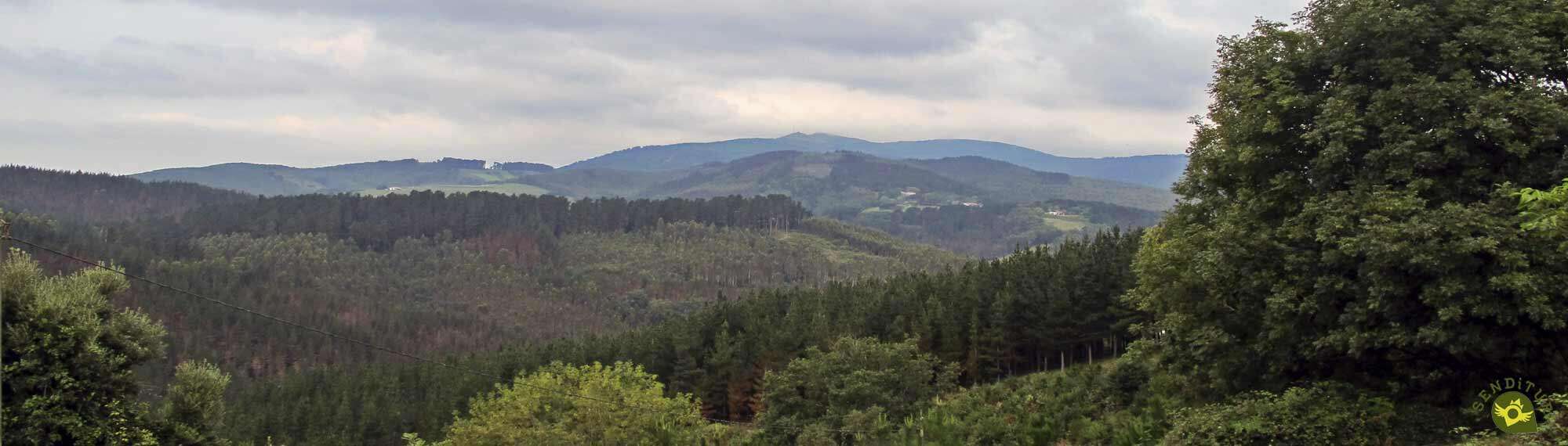
The Urdaibai Biosphere Reserve is the incomparable setting that accompanies the last steps of the GR 38 Wine and Fish Route before reaching its longed-for encounter with the Cantabrian Sea. With the Mundaka estuary at our feet, we will travel through the lush mountains that surround one of the most important wetlands in all of Europe, which enjoys great ornithological diversity, among other virtues.

The stage 7 Gernika-Bermeo covers the 18 km that separate these two towns in Bizkaia, following the old roadways used by the hard-working muleteers who covered the Wine and Fish Route. From Gernika itself we can get an idea of the landscape that awaits us on this route. Mountains full of exuberant vegetation, well cared for baserris surrounded by green pastures and spectacular views with the estuary and the Basque mountains as the main protagonists, will accompany us along the route. The coquettish town of Altamira tempts us to stop and take a closer look at it before facing a new slope.

The asphalt is and will be one of the protagonists of the beginning and end of this stage of the GR 38, although the landscape that will surround us as we walk on it will totally mitigate any hint of monotony that might arise. Bermeo welcomes us with all the warmth that the coastal towns are capable of transmitting. The fishing port to which so many and so many roads arrived and from which so many departed is undoubtedly the best setting in which to end this GR 38 Wine and Fish Route and its stage 7 between Gernika and Bermeo.

Although there is no doubt that any hiker who is travelling along the GR 38 wants to follow the route that this long-distance path draws, in the town of Gernika we have several possible routes, routes that link it with Bermeo and that give us the option of choosing which of them best suits our needs. One of them is the GR 98 Tour of Urdaibai, whose course continues close to the limits of the estuary with a practically flat profile except at the end and with a similar distance between the two towns.
We can reach Gernika - Lumo either from Amorebieta - Etxano or from Bermeo. There are also other roads that connect Gernika with neighbouring towns such as Lekeitio or Mungia, among others. Other possibilities are the Euskotren and the different bus lines that reach it.
This is a complicated stage for our teammate, more than the physical demands, because of the many kilometres on the asphalt. These are roads that will force us to take extreme precautions to avoid problems.
Without water points and villages in between we will have to, as always, take enough water and food to face the route with guarantees.
In addition to the pets that we will certainly find in Gernika and Bermeo, we will have to take into account the dogs and livestock that will be present during the stage.
The Foru Square in Gernika (0h 00min) is the starting point chosen for this last stage of the GR 38.

We started to walk under the arcades that mark one of the main arteries of the town.

For the time being, we will not have to make a detour on any of the streets that come out to meet us.

With each step we leave the centre of Gernika behind us until we reach a garden area where we now turn to our left. We go up a steep street that makes us warm up quickly.

Once we are up, we will return to our lost course to go in search of the limits of Guernica. We find ourselves travelling along what looks like an old road that runs through the last buildings of the town.

A road that we will not abandon at the different crossroads that we encounter.

In front of us we can already see the quarry we are heading for in the mountain.

Our road leads us without major complications to a junction where we will have no choice but to decide the direction to follow, being in this case the paved track on the left that we must follow.

This new road quickly leads us straight to a new crossroads, at which point we will say goodbye to the road and continue parallel to the quarry.

Almost immediately, we will find ourselves before a new detour in which we will continue straight on, leaving on our right the track that, if we follow it, would bring us even closer to the quarry.

From now on, we will see ourselves following an old cart path that gradually leads us into a leafy forest.

As if we wanted to prepare ourselves for the stretch of ascent that lies ahead, our path takes on a certain unevenness with every step we take.

We will soon find ourselves in the midst of the effort to climb the battered path that the itinerary has become. We continue to climb, ignoring the possible detours we may encounter, partly thanks to the vegetation that covers them, as the marks of the GR are conspicuous by their absence.

A vegetation that surrounds us and that together with the marked path that we are following leads us without major complications until the end of this tangled section.

Section that reaches its end when it meets the road through which we must continue to climb.

Now a long journey awaits us again on the asphalt that will be alternating softer areas with others a little more demanding.

Without leaving this road at any time we will reach its final point where another steep path awaits us.

Once again we will find ourselves gaining height, not without effort, surrounded by the thick vegetation that populates this area.

Fortunately, the slope soon gives us a break allowing us to move forward more quickly. Once again we will not have to abandon the path we are following at the different crossroads we are passing through at the moment.

The path we are following crosses the upper part of the mountain with hardly any effort other than that of following its course.

This area can accumulate a lot of mud until it becomes difficult to move forward in some areas.

After a while we will begin to lose the height gained while the vegetation lets us intuit the first buildings that precede our first objective of the day.

The steep descent comes to an end when it encounters the road we have to continue on.

A road in which, immediately, we will find the detour that if we follow it would bring us closer to the interior of the town of Altamira (2h 35min).
We follow the course set by the road we are on in search of the moment to leave it.

A little further on, when our road begins to harden its slope, we will come across the detour we must take.

After a dizzying but short descent, a pleasant walk awaits us, surrounded by imposing trees.

After walking a short stretch along the cemented track that accompanies us in this part of the GR 38 we will find, hidden by the vegetation, the post that signals the moment to say goodbye to this comfortable stretch.

Then a steep trail begins, practically covered by vegetation. Vegetation that once again almost serves us as a reference at the crossroads we pass through to know which is the right way to go.

The unevenness is still important, forcing us to make an effort to overcome it.

After a good while, a marked track appears to indicate the end of this hard and tangled stretch.

But nothing could be further from the truth, as we will immediately say goodbye to the track to resume the climb covered in vegetation.

We are, once again, walking a demanding trail inside a thick forest.

After a while, a solitary post appears before us, inviting us to visit a nearby dolmen, before continuing the course of the Wine and Fish Route.

We follow the course of the trail that guides us in this area, sensing the near end of its itinerary.

After a while, we went out to a new dirt track where we will continue to gain height.

The track quickly leads to the road that will take us to the end of this stage of the GR 38.

A road that continues to make us strive to overcome the unevenness it presents, but for now even pleasant to follow, having freed us from the previous tangled section.

There are still many kilometres of road ahead of us as we leave behind the various crossroads.

Crossings that in most cases do not have any sign of the GR to ensure our good course but thanks to the road that guides us should not complicate our lives.

A road which we must not abandon under any circumstances as it will take us straight to our objective.

After a good while of steep slopes and fast descents the road begins to level out, an unmistakable sign of the still not so close end.

Little by little the first buildings surrounding Bermeo are welcoming us to the town.

Our road leads us directly to the interior of Bermeo, now becoming one of its streets. Streets that will bring us closer to the point where this GR 38 ends.

An urban route that, as usual, does not have the invaluable help of route signs, but fortunately once again does not involve us in unnecessary detours.

The port of Bermeo (5h 40min) awaits us as it did in the past with the muleteers who travelled the Wine and Fish Route, to put an end to our adventure on the GR 38.
 Distance. 18Km
The route we may follow within the localities may vary this figure.
 Time. 5:40h
The different slopes that we will find along the route will condition the time that we will need to travel it.
 Time of year
The proximity of the coast accentuates the variability that the weather can have in this area. It is not unusual to go quickly from a cloudy and grey day to a sunny and hot day or vice versa.
 Required equipment
As we have most of the kilometers on the asphalt in this stage, it may seem to us that a light shoe may be the best option, but we cannot avoid that we will have to face stretches of trails and paths possibly muddy and covered mostly by vegetation, where a boot will protect us much better. The changing weather in this area can also play a trick on us if we do not have a certain margin for these possible changes. As we do not pass through urban areas, it is important to take enough water and food for the whole day. Consult our list of material and equipment for hiking. Read more.
 Difficulty. Moderated
Physical
The steep slopes that we will have to overcome in relatively short distances, added to the total length of the route, make this a physically demanding route. If we also add the kilometres accumulated in previous stages, it may be harder than it really is.
Severity of the environment
The road sections will probably be where we should be most careful, because even though they don't seem to support more traffic than expected, and drivers are not used to meeting walkers on the road. The mud and vegetation can also complicate a stage that otherwise should not have major complications.
Orientation
Perhaps one of the worst stages of this GR 38, fortunately the common sense and vegetation that usually covers the different options that we have to consider in most of the crossroads will be a reference for us to follow. Even so, as always, it would be desirable, it is important, to prepare the route with time and carry the corresponding material that will help us in case of doubt or need, ie map, GPS with the track, etc ...
 |
 |
 |
 |
 |
| 1-Gernika | 0:00h | 6m | 0Km | 30T 526089 4795881 |
| 2-Altamira | 2:35h | 17m | 8Km | 30T 524068 4801521 |
| 3-Bermeo | 5:40h | 2m | 18Km | 30T 522583 4807361 |
Coordinates UTM Datum WGS84

 Slope: 1258m
 Slope +: 629m
 Slope -: 629m
 Maximum altitude: 296m
 Minimum altitude: 2m

This sketch of the route is not made to scale nor does it contain all the information relating to the area, it is merely indicative.

![]()
This schematic with the path is approximate and has been created from the derived cartographic base © Instituto Geográfico Nacional "Cuadrante 062-1, 062-2, 038-3 y 038-4 25.000"
Senditur has manipulated the tracks to correct the aberrant points that may exist, caused by problems with the reception of the GPS signal. In any case the tracks are always approximate. SENDITUR encourages you to use the new technologies within your reach, using them as support and consultation in your activity, not basing the realization and orientation of the same only and exclusively on them, since they may see their functioning altered by very diverse causes, not functioning correctly and their indications may not be precise.


Place of pilgrimages and ancient struggles

Romantic and medieval is one of the symbols of Vizcaya - Bizkaia

Sanctuary of the Santos Antonios, one of the oldest and most venerated in Vizcaya

¿Did you know that...
Opposite the town of Mundaka, at the mouth of the estuary, is the island of Izaro, the largest island off the Basque coast. In addition to some legends, a rich history and having been the logo of a well-known film production company, this island is home to an important colony of birds.
Don't miss out...
The visit to the town of Bermeo as it has, in addition to a beautiful fishing port, with buildings as remarkable as the Convent and church of San Francisco, the Tower of Ercilla or palaces of different architectural styles in addition to being surrounded by an important natural heritage.


From the commitment of SENDITUR with Nature and the respect to the balance of the environment, SENDITUR urges you to travel in a responsible way, with low environmental impact and respecting at all times the Natural, Cultural and Social environment wherever you go.

Besides sharing with all of us your experience on the route we would be grateful if you could write to us to inform us of any erroneous or outdated information you may have found, or simply to let us know what you think at Thank you.
This route has been carried out in the field by SENDITUR on 21-08-2018. The route may vary greatly depending on the time of year, weather conditions and terrain, as well as the actions of third parties and the evolution suffered in the natural environment where it is located. All opinions, advice and/or assessments made by SENDITUR in their descriptions are for guidance only and are subject to and/or refer to the specific conditions of the specific day of the route, referring to that specific day, taken from trained people, with the appropriate experience and with a high level of physical and technical preparation as a reference, as well as correctly equipped.
All the times are approximate and take an orientative character, the stops have not been taken into account, no matter how small they are. All the information related to the route, texts, images, videos, maps, diagrams, tracks, towns, and places of tourist interest are published as a guide, and may not coincide with the current state of each place. Before undertaking any activity, assess your technical knowledge, your physical condition, find out about the weather and the variations that the route may undergo, equip yourself correctly, be prudent and responsible at all times, and do not exceed your capabilities. SENDITUR is not responsible for any misuse or inappropriate use of the comprehensive guides of its routes and/or publications as well as its electronic guides, nor for any variations in their descriptions for the aforementioned reasons, and recommends that everyone be responsible and prudent in carrying out the activity. We also encourage you to read books and specialised guides to complement the information described above.
Continue watching …
 Previous: Section 6 Durango-Gernika


