Greenway of the Oja. Section 1 Casalarreina-Stº Domingo de la Calzada
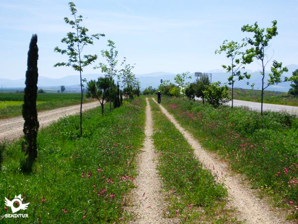
The wide alluvial plain of the Oja valley
The wide alluvial plain of the Oja valley
The Greenway of the Oja, section 1 Casalarreina-Stº Domingo de la Calzada takes us through the great alluvial plain of the Oja valley, in the foothills of the Ebro valley, between the towns of Casalarreina and Santo Domingo de la Calzada in La Rioja.

This first stage of the greenway allows us to enjoy a varied landscape of poplars and farmland, as well as the great cultural and historical heritage of the towns through which the old railway route passes. With 12,7 Km, it not only crosses the immense plain that form the valley of the Oja in its confluence with it of the Ebro, but also part of the nourished history that this land has.

From Casalarreina, with its spectacular historical and cultural complex, with imposing palaces marked by the 16th century Monastery of Nuestra Señora de la Piedad, recalling the bustling activity that gave life for 47 years to the Bobadilla train, the landscapes that we will cross, observed by the Sierra of the Toloño and the Obaranes Mounts, show us the different crops that have a place in La Rioja, from the vine, passing by the wheat and the barley and without forgetting the potato, the cultivation fields will accompany us during the whole route.

At the end of the route, the unmistakable needle of the Tower of the cathedral of Santo Domingo de la Calzada from the 13th century greets us on the horizon, as if they were pilgrims, until we reach Santo Domingo de la Calzada, where this part of the Greenway of the Oja ends.
To get to Casalarreina we can do it by the N-126 from the nearby town of Haro, on this same road is the toll access to the AP-68 motorway. We can also arrive by the N-232 between Logroño and Pancorbo, in addition the LR-111 joins it with Santo Domingo de la Calzada and Ezcaray, the LR-311 joins it with Zarratón and the LR-310 with Cihuri. There are several daily bus lines with stop in Casalarreina that make the routes to Bilbao, Vitoria, Logroño, Santander or Burgos. Once there in the exit towards Logroño for the old national, now Avda. de la Paz, we will find a wide parking and a few meters later the detour of the road towards Zarratón, is in this one and before leaving definitively of the locality, where it begins the way that takes us to the official point of beginning of the greenway.
It is a beautiful route that is almost completely paved, except for the section close to the road, where we are forced to cross the road several times.
We will only find water points in the towns, forcing us to be attentive to the water we carry, especially on hot days, as there are virtually no shaded areas.
The route passes near Santo Domingo de la Calzada between some recreation estates where we can find some mascot, usually within the enclosure, also in the vicinity of urban centers we find similar cases.
We began the route in Casalarreina (0h 00min), travelling part of the road of Zarratón until just at the exit of the locality, next to some agricultural pavilions, we turned to our right to continue by the path that crosses between estates of fruit trees.

With the well of the water in our horizon, this path gives us the first samples of what will be the straight run of the green way. Shortly after passing through it we find, next to the water well, the road that connects Haro with Santo Domingo and on the other side of it the official starting point of the Greenway of the Oja.

Crossing the road we begin a long stretch asphalted and shared with vehicles, in this part of the route they are mixed between the different types of cultivations that characterize this Riojan land.

Leaving to the left and right all the paths that cross with us, we head towards a poplar grove that will give us part of the little shadow that the itinerary has. After leaving this wooded area behind, the road starts a gentle ascent to reach another crossroads where a dirt track begins, parallel to the main path and which avoids the traffic we might encounter.

Little by little we get closer to the edge of the road that we crossed before, until when arriving at its height, the new layout of this one, cuts the old run of the railroad, that without changing its rectilinear course, passed by the outskirts of Castañares de Rioja.

This new route continues between the road and the path that gives access to the different farms in the area, to reach the vicinity of a roundabout. At this point and with the roundabout on our right, we are forced to cross the road that stands in our way to continue along the path that continues encased on the other side. This section next to the road continues until we reach the original layout of the road, at which point, turning sharply to the left, we will leave behind the road company to recover the course that, without detours, will take us to our objective.

This part of the route recovers its good firm again, it could be said that this asphalted one, crosses extensive cereal estates marked with some solitary tree and is crossed with a good number of paths that we will leave to left and right.

The path meets again with a couple of local roads that we will have to cross and continues straight on, observed by the imposing silhouette of San Lorenzo and the mountains that accompany it. Shortly after passing close to a solar plant we arrive, between some recreational farms, we arrive at the meeting of another road that forces us to cross it to continue our journey.

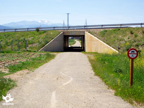
The final part of this section crosses below the national to cover the short distance separating it from the next town it passes through, entering it after passing by a pavilion.

The greenway reaches the outskirts of Santo Domingo de la Calzada (3h 15min) next to the Red Cross post where this stage ends, at the entrance of the old national road that from Logroño passed through here.
The route we have to take to reach the official starting point of the greenway will mark the actual distance to be covered.
The time is calculated without stops and from the town of Casalarreina.
Althoug:the tour can be done at any time, it is in spring and autumn when the walk offers a spectacular and colorful landscape.
Clothes and sports footwear, according to the time of the year and the meteorological conditions, canteen wit:water, sun protection cream, walking sticks and cap as there are no shaded areas practically all the way. Consult our list of material and equipment for hiking. Read more.
Physical
Practically flat, the greatest difficulty is the scarcity of shade that hardens this simple route on hot days. We will also miss some rest area, althoug:the distance is not excessive.
Accessibility
Almost completely asphalted and wit:good road surface, except for the variant that the road has forced to draw and that runs between it and a pat:used to access the farms. In this section we will go throug:a kind of eart:walkway, wit:the option of doing it by the pat:that borders it more treaded and wide.
Orientation
The greatest difficulty is finding the beginning of the greenway, its straight line, althoug:it crosses innumerable paths is well signposted.
| 1-Casalarreina | 0:00h | 505m | 0Km | 30T 507554 4710532 |
| 2-Santo Domingo de la Calzada | 3:15h | 637m | 12,7Km | 30T 504520 4698564 |
Coordinates UTM Datum WGS84

![]() Slope: 150m
Slope: 150m
![]() Slope +: 141m
Slope +: 141m
![]() Slope -: 9m
Slope -: 9m
![]() Maximum altitude: 637m
Maximum altitude: 637m
![]() Minimum altitude: 505m
Minimum altitude: 505m

This sketc:of the route is not made to scale nor does it contain all the information relating to the area, it is merely indicative.

This schematic wit:the pat:is approximate and has been created from the derived cartographic base © Instituto Geográfico Nacional "Cuadrantes 169 y 202, 1:50.000".
Senditur has manipulated the tracks to correct the aberrant points that may exist, caused by problems wit:the reception of the GPS signal. In any case the tracks are always approximate. SENDITUR encourages you to use the new technologies within your reach, using them as support and consultation in your activity, not basing the realization and orientation of the same only and exclusively on them, since they may see their functioning altered by very diverse causes, not functioning correctly and their indications may not be precise.
Find out what to see in...
¿Did you know that...
The route of this railway known as El Bobadilla, which linked the towns of Haro and Ezcaray, was inaugurated on 9 July 1916 and extended until 16 January 1964.
Don't miss out...
The monumental heritage of Casalarreina, declared a National Historic Site, where the Monastery of Nuestra Señora of the Piedad stands out above all.
From the commitment of SENDITUR with Nature and the respect to the balance of the environment, SENDITUR urges you to travel in a responsible way, with low environmental impact and respecting at all times the Natural, Cultural and Social environment wherever you go.
Besides sharing with all of us your experience on the route we would be grateful if you could write to us to inform us of any erroneous or outdated information you may have found, or simply to let us know what you think at Thank you.
This route has been carried out in the field by SENDITUR on 26-10-2015. The route may vary greatly depending on the time of year, weather conditions and terrain, as well as the actions of third parties and the evolution suffered in the natural environment where it is located. All opinions, advice and/or assessments made by SENDITUR in their descriptions are for guidance only and are subject to and/or refer to the specific conditions of the specific day of the route, referring to that specific day, taken from trained people, with the appropriate experience and with a high level of physical and technical preparation as a reference, as well as correctly equipped.
All the times are approximate and take an orientative character, the stops have not been taken into account, no matter how small they are. All the information related to the route, texts, images, videos, maps, diagrams, tracks, towns, and places of tourist interest are published as a guide, and may not coincide with the current state of each place. Before undertaking any activity, assess your technical knowledge, your physical condition, find out about the weather and the variations that the route may undergo, equip yourself correctly, be prudent and responsible at all times, and do not exceed your capabilities. SENDITUR is not responsible for any misuse or inappropriate use of the comprehensive guides of its routes and/or publications as well as its electronic guides, nor for any variations in their descriptions for the aforementioned reasons, and recommends that everyone be responsible and prudent in carrying out the activity. We also encourage you to read books and specialised guides to complement the information described above.
Continue watching …