Welcome to SENDITUR.COM · paths · routes · tourism

![]() Difficulty-Low
Difficulty-Low
![]() 1:30 h.
1:30 h.
![]() 3.8 km.
3.8 km.
![]() Difficulty-Low
Difficulty-Low
![]() 1:30 h.
1:30 h.
![]() 3.8 km.
3.8 km.
The imposing Puigpedrós massif in the Girona Pyrenees, dominated by the 2915 m peak that gives it its name, is one of the great attractions of the Cerdanya-Cerdanya region. There are countless hiking routes in this area of the Pyrenees that lead us to natural landscapes of great beauty. One of these routes is an interesting excursion ideal for the whole family, with the children. It is a simple route that takes us to the Lake of Malniu, a lake of glacial origin marked by the Puigpedrós, a mountain landscape that is quite a spectacle.
To visit the Lake of Malniu, you have to go to the town of Meranges. The accesses leading to Meranges can be found on the road from La Seu d'Urgell to Puigcerdà, passing through Bellver de Cerdanya. Once in Meranges, cross the village to continue ascending along the track that leads to the Malniu refuge. This initially asphalted track soon turns into a dirt track which, depending on the time of year and the weather the previous days, can complicate access to the refuge. In any case, you can check the status of the track on the Malniu refuge website. Once there, you can park your vehicle in the refuge parking area after paying the corresponding fee.
If you have been able to get to the Malniu refuge, thus avoiding the more than 2 hour walk on foot along path 117 that goes up from Meranges, the refuge car park will be your starting point for this route to lake of Malniu. The best thing to do is to follow the track we came on for a few metres, passing the bridge over the Rec de Malniu, to quickly come across the signs that indicate the beginning of the path that leads to the Llac de Malniu. The markings of the Cerdanya Footpaths network, specifically those of footpath 119, will be in charge of guiding us on this hiking route.
In the first few metres you will also see the GR 11 or Trans-Pyrenean Path markings, but you will soon say goodbye to them to go up the course of the Rec de Malniu following the yellow markings of our path.
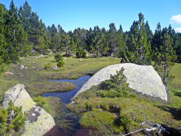
The pine forest and the large granite blocks liven up the route, which climbs with each step we take, but without making any great demands. After a while you reach a new crossroads where you leave the path on your right to continue straight on with the Home Mort mountain range as your witness. Almost without noticing you arrive at the Lake of Malniu (0h 45min), but not before following the path that takes you to its outlet. From here you can walk around the lake and enjoy the scenery. Also, for those who feel like it, you can continue the route and go as far as the Lake of Guils, better known as the lake of Mal, following the marks of path 121. This extension takes about 2.5 km more and 1h 30min approximately, time and mileage that we will have to add to the initial route. The return to the Malniu refuge (1h 30min) is by the same route as the ascent.

Estany de Malniu-CC/Eduard Vives

Refugio de Malniu-CC/Jtrlahti

Estany de Malniu-CC/EliziR
1-Although it is an initially easy route, you should not forget that you are at an altitude of over 2000m.
2-The route in winter can be done on snowshoes or mountain skis, although you will probably have to start the route before reaching the refuge.
3-The flora and fauna of the place and the landscapes invite you to take the time to enjoy watching them, and the route also allows you to do so.
4-Changes in the weather, even in the middle of summer, are very common, so it is important to be vigilant and to be foresighted.
 |
 |
 |
 |
 |
| 1-Malniu Refuge | 0:00h | 2125m | 0Km | 31T 400195 4702024 |
| 2-Lake of Malniu | 0:45h | 2255m | 1,9Km | 31T 400785 4702812 |
Coordinates UTM Datúm WGS84

.png) Distance: 3,8Km
Distance: 3,8Km
.png) Time: 1:30h
Time: 1:30h
.png) Difficulty: Low
Difficulty: Low
 Slope: 310m
 Slope +155m
 Slope -155m
 Maximum altitude: 2260m
 Minimum altitude: 2120m

![]()
This schematic with the path is approximate and has been created from the derived cartographic base © Instituto Geográfico Nacional "Cuadrante 216-2 1:25.000".

¿Did you know that...
The lake of Malniu is linked to mysterious legends and covens which, it is said, used to take place near its shores.
Don't miss out...
The lake of the refuge or Estany Seco, you will find it next to the refuge of Malniu and although it is popularly known as the Dry Lake, in general it always has water.


From the commitment of SENDITUR with Nature and the respect to the balance of the environment, SENDITUR urges you to travel in a responsible way, with low environmental impact and respecting at all times the Natural, Cultural and Social environment wherever you go.

Besides sharing with all of us your experience on the route we would be grateful if you could write to us to inform us of any erroneous or outdated information you may have found, or simply to let us know what you think at Thank you.
Route information updated on 12-06-2021. The route may vary greatly depending on the time of year, weather conditions and terrain, as well as the actions of third parties and the evolution suffered in the natural environment where it is located. All opinions, advice and/or assessments made by SENDITUR in their descriptions are for guidance only and are subject to and/or refer to the specific conditions of the specific day of the route, referring to that specific day, taken from trained people, with the appropriate experience and with a high level of physical and technical preparation as a reference, as well as correctly equipped.
All the times are approximate and take an orientative character, the stops have not been taken into account, no matter how small they are. All the information related to the route, texts, images, videos, maps, diagrams, tracks, towns, and places of tourist interest are published as a guide, and may not coincide with the current state of each place. Before undertaking any activity, assess your technical knowledge, your physical condition, find out about the weather and the variations that the route may undergo, equip yourself correctly, be prudent and responsible at all times, and do not exceed your capabilities. SENDITUR is not responsible for any misuse or inappropriate use of the comprehensive guides of its routes and/or publications as well as its electronic guides, nor for any variations in their descriptions for the aforementioned reasons, and recommends that everyone be responsible and prudent in carrying out the activity. We also encourage you to read books and specialised guides to complement the information described above.
Continue watching …


