![]() Difficulty-Moderate
Difficulty-Moderate
![]() 3:55 h.
3:55 h.
![]() 7.5 km.
7.5 km.
![]() Difficulty-Moderate
Difficulty-Moderate
![]() 3:55 h.
3:55 h.
![]() 7.5 km.
7.5 km.
The Natural Park of the Headwaters of the Ter and Freser, located in the eastern Pyrenees in the province of Girona, within the county of Ripollès, brings together a wide range of heritage, not only natural, but also historical and cultural. There are numerous hiking routes to be enjoyed in this area of the Catalan Pyrenees, and one of the most emblematic of them all, due to its deep-rootedness and the beauty of its landscapes, is probably the Old Path from Queralbs to Núria. This hiking route has become one of the most popular excursions in the Vall de Núria, with permission of the famous rack railway that links the village of Queralbs with the Sanctuary of Núria. This route follows the old path that pilgrims and pilgrims used to follow to visit the Virgin of Núria, before the construction of the railway line that is now a tourist attraction in the Vall de Núria. The route allows us to discover treasures such as the Sant Pau cave, the Cremal bridge and the Cua de Cavall waterfall, as well as crossing the Gorges de Núria, a real experience.
The start of the path from Queralbs to Núria can be found in the parking area of the Núria rack railway. To get to Queralbs, go to the town of Ribes de Freser, on the N-260 national road. Once there, follow the local road that connects it with Queralbs, and just before arriving you will come across the large parking area for the Núria rack railway, where you can park your vehicle and start the route. You can also get to Queralbs by train, passing through Ribes de Freser.
Although there are several areas where we can park our vehicle, in our case we are going to take as the starting point of the route between Queralbs and Núria the parking lot of the rack railway that joins them. From the car park there is a walkway that allows us to follow the course of the road from Ribes de Freser into Queralbs. As soon as you enter Queralbs, in the square itself, you will see the signs informing you of the different routes that you can follow in this area, including our own, the Camí de Núria or Old Path from Queralbs to Núria. The itinerary guides you through the streets of Queralbs, gradually leading you out of this typical village in the Catalan Pyrenees. Soon you will find yourself following an old path marked out by the different plots of land that you are crossing. Plots belonging to the farmhouses that are concentrated here. The Ruira spring is a good place to take a break to allow us to face what lies ahead. The slope is demanding but allows us to enjoy the landscape, a landscape marked by the Vall de Núria rack railway, which accompanies us.
We leave the course of the Roc del Dui path to one side as we head towards the river Núria, passing through the Sant Pau cave. We soon reach the Romanesque bridge of Cremal, which we cross to enter the Nuria gorge for good.
The Sant Rafael cave and the Sastre Waterfall mark the beginning of another demanding stretch that takes us to the Sant Pere cave, from where we can contemplate another of the wonders of this hiking route through the Vall de Núria, the Cua de Cavall or Horse's Tail. After enjoying this natural spot and regaining our strength, we resume our walk. With each step, the gorge becomes narrower and narrower until you reach the green meadows of Pla de Sallent. Once there, you will have to cross the rack railway tracks, thanks to the tunnel that allows you to pass under them, to face a new stretch of steep ascent. The effort after overcoming this steep slope is rewarded with our arrival at Creu d'en Riba, from where we can now contemplate the Olla de Núria, where the sanctuary is located. At this point we should not miss the opportunity to take a detour a few metres to the nearby viewpoint on our right. We resume our walk along the marked path that takes us to the hermitage of Sant Gil, where tradition has it that the Virgin was found. From there you only have to walk the path that separates you from the Núria Sanctuary (3h 55min), where this hiking route ends. There are two options for the return journey: you can either follow the same route you came along, or take the rack railway that will take you back to the car park from where you started.
1-Although there are several fountains along the route and there are tourist services around the sanctuary, we must take water with us for this route and equip ourselves correctly.
2-Initially, the route is not very complicated, although you should not forget that it is a mountain route that passes through areas abrupt and with slopes.
3-Si tienes pensado regresar con el tren de cremallera no está de más que consultes antes los horarios y la disponibilidad en el next link.
4-This route can be done practically all year round, although in winter it is necessary to consult the avalanche report and the route may require the use of crampons and ice axes.
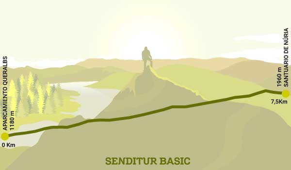
| 1-Queralbs Parking | 0:00h | 1180m | 0Km | 31T 431257 4689142 |
| 2-Núria Sanctuary | 3:55h | 1960m | 7,5Km | 31T 430332 4694214 |
Coordinates UTM Datúm WGS84

![]() Distance: 7,5Km
Distance: 7,5Km
![]() Time: 3:55h
Time: 3:55h
![]() Difficulty: Moderate
Difficulty: Moderate
![]() Slope: 960m
Slope: 960m
![]() Slope +865m
Slope +865m
![]() Slope -95m
Slope -95m
![]() Maximum altitude: 1995m
Maximum altitude: 1995m
![]() Minimum altitude: 1180m
Minimum altitude: 1180m

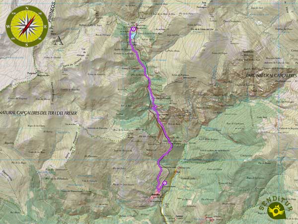
This schematic with the path is approximate and has been created from the derived cartographic base © Instituto Geográfico Nacional "Cuadrante 218-3 y 217-4 1:25.000".
¿Did you know that...
The Núria rack railway was inaugurated in 1931 and runs for 12.4 km in just 40 minutes, passing through 4 stations.
Don't miss out...
A visit to the Romanesque church of Sant Jaume in Queralbs, whose architecture, typical of this area of the Pyrenees, is worthy of admiration.
From the commitment of SENDITUR with Nature and the respect to the balance of the environment, SENDITUR urges you to travel in a responsible way, with low environmental impact and respecting at all times the Natural, Cultural and Social environment wherever you go.
Besides sharing with all of us your experience on the route we would be grateful if you could write to us to inform us of any erroneous or outdated information you may have found, or simply to let us know what you think at Thank you.
Route information updated on 15-06-2021. The route may vary greatly depending on the time of year, weather conditions and terrain, as well as the actions of third parties and the evolution suffered in the natural environment where it is located. All opinions, advice and/or assessments made by SENDITUR in their descriptions are for guidance only and are subject to and/or refer to the specific conditions of the specific day of the route, referring to that specific day, taken from trained people, with the appropriate experience and with a high level of physical and technical preparation as a reference, as well as correctly equipped.
All the times are approximate and take an orientative character, the stops have not been taken into account, no matter how small they are. All the information related to the route, texts, images, videos, maps, diagrams, tracks, towns, and places of tourist interest are published as a guide, and may not coincide with the current state of each place. Before undertaking any activity, assess your technical knowledge, your physical condition, find out about the weather and the variations that the route may undergo, equip yourself correctly, be prudent and responsible at all times, and do not exceed your capabilities. SENDITUR is not responsible for any misuse or inappropriate use of the comprehensive guides of its routes and/or publications as well as its electronic guides, nor for any variations in their descriptions for the aforementioned reasons, and recommends that everyone be responsible and prudent in carrying out the activity. We also encourage you to read books and specialised guides to complement the information described above.
Continue watching …