Welcome to SENDITUR.COM · paths · routes · tourism


Mount Ori from the Col of Larrau
Ochagavía-Otsagabia, Navarra![]()
![]()
![]()
![]()
![]() (1)
(1)
Emblematic and magical mountain of the Navarrese Pyrenees
![]() Difficulty-Medium
Difficulty-Medium
![]() 1:45 h.
1:45 h.
![]() 4.8 km.
4.8 km.
Ochagavía-Otsagabia, Navarra![]()
![]()
![]()
![]()
![]() (1)
(1)
Emblematic and magical mountain of the Navarrese Pyrenees
![]() Difficulty-Medium
Difficulty-Medium
![]() 1:45 h.
1:45 h.
![]() 4.8 km.
4.8 km.
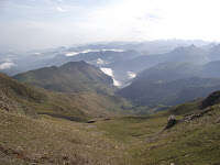
To the north of the Salazar valley, in its highest part, acting as a natural border with France, stands proudly the unmistakable silhouette of an emblematic and mystical mountain. The ascent of Mount Ori from the Pass of Larrau gives us the opportunity to crown this beautiful summit and enjoy the imposing panoramic views offered by the clear days, a contrast between the green meadows, the thickness of the woods and the profiled figure of the Pyrenean mountains.

The ascent has 4.8 km from the port of Larrau, being of the different routes the one that more travelled is, given its relative and apparent simplicity. Also known as Orhi Peak we are in front of a beautiful pyramid of little more than 2000 m that separates to the south the valley of Salazar with its impressive Irati Forest, with the valley of Larraine to the north, something more wild as it is witnessed by the glacial circuses that extend for that slope. The ascent takes us through the soft and green hillsides of the Navarra mountain slope, gaining height calmly but without pause, bordering the hillside of the Ori Txipi. It is here where, in addition to finding the most rugged and entertaining part of the ascent, we will have to face the decision of which route to choose, the steep and demanding south-east ridge or the most amiable south-west ridge.

In any case the summit of Mount Ori awaits us to show us the spectacular landscape that is contemplated from it. The thickness and the colourful carpet of the Irati Forest or the unmistakable silhouettes of the Pic d'Anie or the Table of the Three Kings are a small sample of what this summit can offer us above all on days of good visibility. From Orhi Peak, to which innumerable routes arrive, we descend to return to the starting point not without first visiting the modest Ori Txipi, before resuming the path that leads us back to the Col of Larrau.

Many years ago, near a small village lived a beautiful lamia with long hair that he used to comb with his gold comb and then let them caress by the gentle wind. In the evenings, unruly by nature, she used to go through the chimneys of the houses to have fun without evil scaring the locals. The latter, fed up with her mockery, decided to punish her and agreed with a sorcerer, in order to give her a lesson, to lock her up for a short period of time in a cave at the top of Mount Orhi. But the same night that the wizard locked her up, the inhabitants of the village saw how this one, with no one who could oppose him, stripped them of everything that they had worked so hard to achieve and then disappear and never return again, leaving the beautiful lamia locked forever at the top of the Ori peak, where the wind now blows hard as if it wanted to cross the mountain to caress again the long hairs of the unruly lamia.
The access to the Col of Larrau from the Spanish side of the mountain can be found on the NA-140 road linking Ochagavía, in the valley of Salazar, with Isaba, in the valley of Roncal. A few kilometres after leaving Ochagavía in the direction of Isaba, you will come across the beginning of the road that climbs up to this mountain pass. Once there, just before passing under the Larrau tunnel, there is a small parking area from where we can start, if we choose, the ascent. If, on the other hand, we decide to start from the top of the pass, we will only have to cross the tunnel and go up the few metres that remain to crown it, where we will find a large parking area and the beginning of the route. We can also access the pass from the town of Larrau on the French side.
Good Pyrenean mountain to start our friend in the world of mountaineering, by slope and distance will be a good test for him. Attention on the road, in summer more cars pass than we can expect.
We must not forget to bring him some water and food so that he can, like us, regain strength at the end of the Orhi ascent.
The cattle graze on these hillsides so we will probably have to find some flock. Watch out, in autumn is hunting season and especially at the beginning of the ascent we will encounter several hunting posts.
The pass of Larrau (0h 00min), more specifically the car park when it is crowned, is the starting point for this ascent to Mount Ori or Orhi Peak as it is also known.

If we descend a few metres along the road that leads down to the tunnel we have probably come through, we will find the beginning of the path that will take us to the top.

At the moment we realize the continuous slope that we are going to have to save while we begin to gain height furrowing the hillside of the mountain.

The footpath cuts through the green meadows at the same time as it brings us closer to the small houses that act as stalls for hunters.

We keep going up the mountain with each step, crossing some cobblestone areas.

Shortly afterwards, with the silhouette of the Ori Txipi summit watching us, we arrived at a small hill where we are joined by the mountaineers who chose the mouth of the Larrau tunnel as the starting point for their ascent.

If we look back we can see perfectly the course that follows its path to get here from the tunnel.

Already together we continued with the ascent by the skirt of the mountain without crowning the small top that we had in front of us.

There are several trails that the cattle have been drawing with the passage of time, although the one that we must follow, in general, is much more marked. Some solitary stone milestone also serves as a reference in case of need.

With each step we get closer to the most abrupt stretch of the whole ascent, the one that cuts the hillside of the Ori Txipi.

In this enrocada zone we will have to look for the route that is more comfortable to us to save it. Although the towline of this simple climb gives us a clue to where we should go.

After overcoming this simple climb in which if we choose well we should not have to use our hands more than if we hold on to the towrope, advisable especially if the rock is wet, the trail will gradually return to recover its protagonism.

We continue along the slope of the mountain, quickly approaching the bifurcation (0h 45min) of trails already shown in front of us.
Here we will have to decide which face we want to ascend. The path on the right takes us to the hill between the Orhi and the Ori Txipi, and from there we undertake the steep and hard ascent of the southern ridge of the Ori.

The trail on the left in exchange for a slightly longer route offers us a much more benevolent slope than its sister.

We postpone the ascent for now and continue on the left while we see how the other path continues to gain height.

The steep slope up to this point gives us a little respite as if we wanted to recover our strength for the final ascent.

From the trail that runs over our heads descend others that join ours, the safest created by people who thought better and changed their minds. The route takes us to the same left shoulder of the Ori.

Here joins us another one of the trails which ascends to this mythical top of the Pyrenees. As soon as we go out to this kind of col, the route turns round and heads towards the top of the mountain, although without attacking it directly.

After a small zigzag, the trail takes us directly to the summit of Mount Ori (1h 10min). This summit is quite long finding first the geodesic vertex and then the other two small summits that compose it.
Once we have enjoyed the spectacular scenery offered by the Orhi Peak, we must decide where we will descend.

If instead of doing it by the same place we go up, we want to do it by the southeast edge, we will only have to cross the top until we reach it.

As soon as we look out the edge makes clear the important slope that has, not suitable for inexperienced. The trail quickly loses height, initially close to the apex of the steep slope.

But a few meters below it changes course separating us from the emptiness that to our left hides us the slope of the mountain.

With caution we are describing the small zetas that help us to save the slope. The well marked and not excessively decomposed path facilitates the arduous task of descent.

Almost without realizing it, we see ourselves at the gates of the col that separates the two sister peaks. Here we see perfectly the trail that comes from the bifurcation that in the ascent we left behind and towards which we will go after crowning the mountain that we have in front of us.

We set course towards it following the shoulder of the mountain, crossing the few meters that separate us from the milestone that marks the top of the Ori Txipi (1h 20min).
Crowned this top of the Pyrenees we return following our steps towards the pass that we have left behind.

There awaits us the trail by which we will continue the descent that will take us to the end of the ascent.

We quickly meet at the bifurcation (1h 25min) where we rejoin the mountaineers who chose to descend following the same route that led them to the summit of Pico Orhi.

Already together we have to face the entertaining zone of rocks, which we will descend with caution.

Once this obstacle has been overcome, the path leads us down the mountain without too many complications, until we come across the detour that those who started next to the Larrau tunnel must follow.

The rest of us will have to follow without detour the marked course of our footpath that will take us until the parking lot of the Pass of Larrau (1h 45min) where we will give already finished this ascent to the Orhi.
 Distance. 4.8Km
Descending the same slope should not change this figure.
 Time. 1:45h
There is no great difference between crowning the Ori Txipi or not doing so, or descending the Pico Orhi by one side or the other, but it may be more remarkable to ascend the southeast ridge in which case you can add a few minutes to the total time, depending on your physical form.
 Time of year
In normal conditions and with good visibility we are in front of a mountain of the Pyrenees that offers spectacular panoramic views throughout the year, although in season of the passage of the pigeon may not be such a good idea to pass through certain areas of the route because they pass very close to the positions of hunters. In winter conditions, not only does the landscape change, but also the route we must follow in order to ascend to this beautiful peak.
 Required equipment
We should not underestimate this mountain and the route that crowns it, the changes of time are fast and more habitual than we can think to what is added the strong wind that normally blows by these heights. This advises us to equip ourselves not only with the appropriate footwear, for example trekking boots, but also with short wind or warm clothes in case we need them. Water and food along with sun protection and canes is also advisable to accompany us. All this of course as long as the snow or ice is not present, in which case the minimum material that we must carry is extended. Consult our list of material and equipment for hiking. Read more.
 Difficulty. Medium
Physical
This is a short but demanding route that from the beginning forces us to gain height almost without pause, but thanks to its relative short distance allows us, if we have the necessary time, take it with the calm we deem appropriate. If we choose to ascend the southeast ridge, the difference in level that we will have to face is much greater by increasing the level of the route.
Severity of the environment
There are several points where we will have to increase the precautions that we must always take. The first is located in the short, somewhat steep area that borders the skirt of the Ori Txipi. Here the steepest section is equipped with a towline that gives us greater confidence and safety in this area of the ascent, simpler than it might seem whenever we choose the right route to follow. With the rock wet, this towrope will undoubtedly be a very grateful resource for those who are forced to pass through here. The southeast ridge of the Ori is another of the stretches in which the difficulty and the exposure to falls are extended, so before venturing to cross it, especially the descent, we will have to value our knowledge and skill as well as the state of the terrain. For the rest we are in front of a pleasant path that if we do not get out of it should not put us in great difficulties, as long as we do not underestimate the meteorological conditions nor our capacities.
Orientation
The route is not signposted, the great advantage that it offers and that is of great help to us to follow the route with relative ease is the tread of the path that we have to follow. It is true that the cattle have created several trails that can make us doubt but that should not take us very far from the right one. To begin the ascent to the Ori from the tunnel of Larrau, to our return, it is easy, if we do not go down attentively, that we skip the detour that descends until the tunnel. Another point that generates more than one doubt is at the fork in the path where we must choose whether to ascend the steep southeast ridge or the more benevolent slope. If we regret our choice, we can, a little higher up, follow one of the narrow paths that take us back to the path that leads to the least demanding ascent.
 |
 |
 |
 |
 |
| 1-Col of Larrau | 0:00h | 1475m | 0Km | 30T 663579 4759876 |
| 2-Bifurcation | 0:45h | 1874m | 1.4Km | 30T 662788 4760873 |
| 3-Mount Ori | 1:10h | 2019m | 2.3Km | 30T 662556 4761475 |
| 4-Ori Txipi | 1:20h | 1925m | 2.9Km | 30T 662783 4760960 |
| 5-Bifurcation | 1:25h | 1874m | 3.4Km | 30T 662788 4760873 |
| 6-Col of Larrau | 1:45h | 1475m | 4.8Km | 30T 663579 4759876 |
Coordinates UTM Datum WGS84

 Slope: 960m
 Slope +: 480m
 Slope -: 480m
 Maximum altitude: 2019m
 Minimum altitude: 1475m

This sketch of the route is not made to scale nor does it contain all the information relating to the area, it is merely indicative.

![]()
This schematic with the path is approximate and has been created from the derived cartographic base © Instituto Geográfico Nacional "Cuadrante 091B-3117-2, 1:25.000"
Senditur has manipulated the tracks to correct the aberrant points that may exist, caused by problems with the reception of the GPS signal. In any case the tracks are always approximate. SENDITUR encourages you to use the new technologies within your reach, using them as support and consultation in your activity, not basing the realization and orientation of the same only and exclusively on them, since they may see their functioning altered by very diverse causes, not functioning correctly and their indications may not be precise.


Pilgrimage destination in honour of the patron saint of Navarre, Saint Francis Xavier

Find out what to see in...
¿Did you know that...
Pico Orhi is the most western mountain in the Pyrenees which is over 2,000 m high, or if you prefer, the first peak in the Pyrenees to exceed 2,000 m as we enter them from the Cantabrian Sea.
Don't miss out...
The Nature Interpretation Centre that you will find in Ochagavía, where, in addition to information on the geology, fauna and vegetation of the area, you can also visit exhibitions or carry out activities related to the Salazar Valley and the Irati Forest.


From the commitment of SENDITUR with Nature and the respect to the balance of the environment, SENDITUR urges you to travel in a responsible way, with low environmental impact and respecting at all times the Natural, Cultural and Social environment wherever you go.

Besides sharing with all of us your experience on the route we would be grateful if you could write to us to inform us of any erroneous or outdated information you may have found, or simply to let us know what you think at info@senditur.com Thank you.
This route has been carried out in the field by SENDITUR on 24-08-2016. The route may vary greatly depending on the time of year, weather conditions and terrain, as well as the actions of third parties and the evolution suffered in the natural environment where it is located. All opinions, advice and/or assessments made by SENDITUR in their descriptions are for guidance only and are subject to and/or refer to the specific conditions of the specific day of the route, referring to that specific day, taken from trained people, with the appropriate experience and with a high level of physical and technical preparation as a reference, as well as correctly equipped.
All the times are approximate and take an orientative character, the stops have not been taken into account, no matter how small they are. All the information related to the route, texts, images, videos, maps, diagrams, tracks, towns, and places of tourist interest are published as a guide, and may not coincide with the current state of each place. Before undertaking any activity, assess your technical knowledge, your physical condition, find out about the weather and the variations that the route may undergo, equip yourself correctly, be prudent and responsible at all times, and do not exceed your capabilities. SENDITUR is not responsible for any misuse or inappropriate use of the comprehensive guides of its routes and/or publications as well as its electronic guides, nor for any variations in their descriptions for the aforementioned reasons, and recommends that everyone be responsible and prudent in carrying out the activity. We also encourage you to read books and specialised guides to complement the information described above.
Continue watching …