Welcome to SENDITUR.COM · paths · routes · tourism


![]() Difficulty-Medium
Difficulty-Medium
![]() 2:30 h.
2:30 h.
![]() 8.4 km.
8.4 km.
![]() Difficulty-Medium
Difficulty-Medium
![]() 2:30 h.
2:30 h.
![]() 8.4 km.
8.4 km.
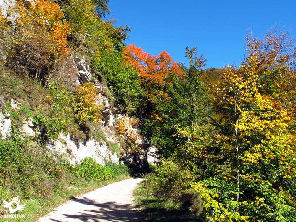
The Zabaleta Forest Trail takes us into a small part of the extensive territory occupied by the Irati Forest, more specifically in the area belonging to Ochagavía. It is a true natural paradise in which nature and the different industries that took place here have coexisted for years, such as timber, livestock or iron, which, with old forges, have left their mark, contributing a cultural interest to the important landscape and natural value of this area. Beeches, firs, streams and a large number of actors with their special peculiarities make each season of the year a spectacle worth seeing and visiting.

The 8.4 km route follows the Zabaleta forest path that takes us from the welcome centre of the Irati Houses, where the car park is located, to a route through the interior of the Irati Forest, following the course of the river that feeds the Irabia reservoir. A walk through this natural sanctuary, surrounded by the leafy vegetation that characterises it and which gives its special colour to each season of the year, making it a different route in each season. Iturri spring is the antechamber of a large number of streams and torrents that, like veins, feed the already plentiful river with water. An itinerary that gives us the opportunity to enter the interior of the forest looking to gain height while we leave at our feet the main track and the river that follow their course at the bottom of the valley.

The place presents us with a great variety of types of trees, beeches, firs... or thick bushes that populate everything that surrounds us at every step. The route gives us the chance to follow two itineraries that join and separate several times along the way, allowing us to choose the option that interests us most. The house of the forest precedes the great Irabia Reservoir fringed by different paths or routes that surround it, although ours only brings us closer to the beginning of this reservoir. It is here where on both sides we will see ourselves almost surrounded by the water, on one side the amplitude of the reservoir itself and on the other the beginning of it, where the river and its whimsical flow draw closed meanders before ending in the reservoir. From this place a quiet return awaits us in which we will be able to follow the zones of the route that before we had left aside and that without a doubt take us by interesting and beautiful corners.

We will wade along streams, going up and down their bed to cross the great forest covered with dry leaves, a forest that barely allows sunlight to enter. By following the track on the way back, it will allow those who had previously followed the path to get an idea of the unevenness that separates it from the path they are now following. As a final touch, the car park is waiting for us in a conditioned recreational area where we can approach the river, which is so far away from us almost the whole way, or visit the hermitage of the Virgen de las Nieves, among many other alternatives.
Those who, due to the state of the route or their own decision, choose to do so can continue on the track instead of taking the detours that follow the paths through the forest. From this form at the cost of missing the magnificent journey through the interior of the forest, avoiding so many ups and downs, wading streams or muddy trails.
There are quite a few towns from which we can access, in one way or another, the Irati Forest due to its amplitude, but to follow this route we must go to the town of Ochagavía. We arrive at this locality following the NA-140 that reaches Ochagavía from the N-135 that joins Pamplona with Roncesvalles, finding the detour shortly before arriving at Roncesvalles, just in the section that goes from Espinal to Burguete. This same road NA-140 but on the other side connects Ochagavía with Isaba and France. You can also get there via the NA-178, which links the A-21 motorway between Pamplona and Jaca at Lumbier with the NA-140 in Ezcároz, a neighbouring town of Ochagavía. Once there and as you reach the town from Ezcároz, just before crossing the bridge over the river that separates us from the town of Ochagavía, you will find the crossroads where the road that will take you to the Irati Houses begins. Continue along this road, leaving the village on your right, going up the course of the river Zatoia. This road leads us without loss and after a few kilometres to the reception and information centre for visitors and the place to leave our vehicle.
The park allows the access with pets whenever we take them tied, so much to avoid annoyances to other visitors or to the animals that live here, as to avoid that our friend does more heed to his instinct that to us and he gets involved in following some trace that distances him too much, there have been cases of dogs found to enough kilometers of distance. Also and although the route is not very demanding, nor the terrain too abrasive, if our friend is not very accustomed to the walks through the mountains is interesting to wear a protector for the pads, just in case.
In the points of water of the beginning of the route we will be able to fill the reserves that without a doubt we must take since from now on it is very probable that depending on the time of the year in which we make the route we will not find so easily points of water where it can drink and the reservoir is not the best idea.
To the mascots that we can find we must add the fauna of the zone, since this is a cattle land par excellence, the regulation of the park asks to respect, as it cannot be of another way, to the flora and fauna of the zone.
The car park (0h 00min), next to the welcome centre for visitors to the Irati Houses, kicks off this route.

The itinerary begins leaving on the left the information booth of the park and to our right a picnic area. We follow the wide track marked with the signposting corresponding to the Sendero del Bosque de Zabaleta SL NA-63A that we will identify by its green and white marks.

Soon we are surrounded by the thick vegetation that accompanied us in practically all the route.

Shortly after starting the march and having passed the short path that leads to the nearby source of Iturri we find the detour that we must follow.

To our right begins a steep path that will make us gain height quickly while introducing us definitively into the heart of the Irati Forest.

This part of the route runs through a wide path conditioned with wooden steps in their sections of greater inclination, even so the almost habitual mud, the stone chips and the roots of the trees that appear of the ground, make something more uncomfortable our advance.

The itinerary soon softens its demanding slope, allowing us to catch our breath and enjoy the beautiful surroundings while we follow a path upholstered in dry leaves. After a while, the thicket that barely lets the sun's rays through gives us a truce, allowing us to enjoy some privileged views as a reward for our effort to get here.

The path in this area has lost its width leaving us hardly any space to walk on, the grasses do not allow us to see the limits of the path but let us intuit the little margin we have, while we hide in part the verticality of the section we are crossing.

Soon the trees recover their lost protagonism and plunge us back into the gloom of the forest, at the same time that the path recovers its lost width.

The torrents of water, normally dry, are habitual in this route forcing us to descend until its bed to cross them and to continue with the march.

The path completely covered by the leaves leaves leaves no doubts about their trajectory making it easier to follow the right course through the interior of the forest. After a while our path gains width to become a kind of forest road by which we begin to descend in search of the river that we left at our feet before.

Soon the route turns sharply to the left to find a path to follow the descent through it, it is thanks to some barriers or railings made with logs that prevent us from skipping this crossing and continue along the path although this seems to disappear a few meters later.

We then begin a fast and zigzagging descent that takes us back to the bed of a stream that we must cross.

Once the steepest stretch and the stream have been saved, the path leads us directly to the track we had previously abandoned to follow this route. When it reaches its height, the route continues along it, continuing to the right.

Here we must be aware that the only signpost that we can see is on our left and is at the junction point of the path that will take us back from the reservoir and the track that will take us to the Irati Houses. We leave this link behind us to follow the path that brought us here.

Now a pleasant walk awaits us on this wide track that crosses some torrents of water without this time we have to make balances to cross it.

After a short time, and in the middle of a curve, we will come across the layout of the trail through which we will return and which touches our track at this point, so we should not hesitate as it is most likely that we see the marks that mark it with part of its layout.

We must follow the track that will take us without major complications to the detour that leads to the forest house and the reservoir.

After a short section more of track we will find with the crossing in the one that we will leave the track by which we arrived that continues its straight run, to turn completely and to undertake the descent that takes us up to the house of the forest one.

When you reach your height, leave the beginning of the path on your left and continue bordering it on your right, following the path that descends to almost the same edge of the Irabia Reservoir (1h 20min). Here several routes cross once again, whose signs should not confuse us, unless our intention is to turn around the whole reservoir.

Once enjoyed this splendid place we have to go up the short slope that separates us from the Casa del Forestal to take the path that we left aside before.

Either at the front of the house or the one we saw when we arrived, the beginning of the path awaits us and takes us back into the lush forest. The same stream that we had not paid attention to before when we passed over it following the track, now forces us to make some balance to cross it.

Just past it begins a steep ramp that makes us gain height quickly and relatively easily thanks in part to the serpentine that draws on the slope of the mountain.

At the end of the ascent to our left we will be able to see the track that before led us until the reservoir, we guided now by the signposting of the footpath and by the wooden railings, we follow the trajectory that these mark us without leaving the footpath that we take, although this one does not seem to be so marked as before.

Nothing further from reality, at the moment we will see ourselves following a well-defined path that will make us lose the height previously gained.

This part of the route crosses crossing some streams, with its consequent ups and downs, in addition it crosses, without us being able to see them, the meandering area of the river, which will bring us closer and further away from it, a fact which, together with the sometimes less marked path, can confuse us or make us think that we have made a mistake.

On the other hand, the route follows an almost straight course that is barely altered by the obstacles it encounters on its way. The dry leaves cover practically everything forcing us to be attentive to follow the marks and signs that indicate the way.

The streams cross each other at our pace, making it difficult for us, depending on their flow, to pass through them.

A steep and, with mud, delicate descent takes us to one of them and after crossing it we gain height again through the forest.

Once again we will have to face another stream that makes us doubt if we really cross so many streams in the course of the track.

Luckily after this beautiful and undulating stretch our path leads us directly to the meeting of the track in the same place where we had met it for the first time some time ago. Now a long stretch awaits us on this track that will take us back to the starting point of the route.

Contrary to what it might seem, this part of the route will also make us uncomfortable with ascents and descents, although without the unevenness of past ramps.

The track in its course is encountering other ways that should not lead to error as the good condition of the track to follow leaves no room for doubt.

After a while, we arrived at the crossroads where we turned off to follow the path that took us to the highest area of the entire route, a moment in which the sensation of the near end of the tour takes hold of us. The Irati House and the car park (2h 30min) await us a few metres away, but not without first visiting the nearby river that, hidden by the vegetation, has accompanied us throughout most of the route.
 Distance. 8.4Km
The different options offered by the route may vary this figure.
 Time. 2:30h
Although we could cover the distance in less time, it is the orography of the terrain and the beauty of the environment that surrounds us at each step that forces us to take the route calmly and face the ramps that we must climb and descend without stress. For those who decide to follow the track in its entirety, even though it makes the route a little longer, they will not appreciate a great difference with the proposed layout.
 Time of year
The great beauty of the Irati Forest makes it difficult to choose one or another time of year, although in winter the snow makes it difficult to get there, it also brings a special charm to the route although it increases its difficulty and conditions us to follow the whole track. Autumn and spring bring their characteristic colours that make Irati, in these seasons, a place of obligatory visit for those who like to know these places in all their splendour. The summer guarantees a pleasant walk protected from the sun and enjoying the freshness that brings us the lush forest.
 Required equipment
Although we decide to follow only and exclusively the track without deviating by any of the trails is advisable to do so with sneakers or trekking boots, we will gain in comfort and safety. For the rest we must have clear that we are in full nature reason why we have to adapt our clothes and footwear to the time that we choose to realize the route and to be foreseeable, since the time changes quickly in the mountain. We have fountains at the beginning of the tour where we can get the water we need during the walk, some food, the map of the area we are given when we get to the welcome center and canes are also advisable. Consult our list of material and equipment for hiking. Read more.
 Difficulty. Medium
Physical
With strong but not very long ramps and a reasonable total distance, this is a route that for someone moderately accustomed to walking should not cause major problems, as long as you take the ramps with patience and do not leave your energies on them. The heat is not usually a conditioner, but the humidity can harden the journey even not doing too much temperature.
Severity of the environment
It is important not to underestimate the route, although the track does not represent major complications, being in good condition and not passing through exposed areas. The paths follow mountain paths in which mud, roots and stone slabs will ask to be attentive when we meet them. In addition there are streams or torrents that we must wade so it is not too much to consult the guards the state of these places to avoid unnecessary complications. Another point in which we must be attentive especially if we go with children is in the first path, in the clearing of the forest where the path narrows, here we pass over a rocky outcrop that we will see when we return by the track and although in normal conditions this stretch of path does not cover major complications, the vegetation, apart from hiding the almost vertical drop that we have a few meters, also covers the limits of the path without letting us see where the mainland ends and the fall begins. Pay attention to slips and falls, mud and streams undoubtedly contribute to give us a good scare.
Orientation
The route is fully signposted, although the confluence of other itineraries and the crosses with the different routes that our route follows may make us doubt the path to follow. In addition, the last section of the path is the one that can cause us the most problems as it almost disappears under the leaves in some areas and the orientation of the posts that indicate the route is the only reference to follow, as long as they are well oriented. Luckily, the course of the route in these sections, almost straight, and the prompt recovery of the path will surely make us recover the lost tranquility. The map given to visitors is a good ally in case of need, as long as we have bothered to ask which is the line that follows our route.
 |
 |
 |
 |
 |
| 1-Parking | 0:00h | 855m | 0Km | 30T 654359 4761319 |
| 2-Detour | 0:05h | 860m | 0.3Km | 30T 654111 4761169 |
| 3-Irabia Reservoir | 1:20h | 830m | 4Km | 30T 651750 4761186 |
| 4-Parking | 2:30h | 855m | 8.4Km | 30T 654359 4761319 |
Coordinates UTM Datum WGS84

 Slope: 762m
 Slope +: 381m
 Slope -: 381m
 Maximum altitude: 980m
 Minimum altitude: 830m

This sketch of the route is not made to scale nor does it contain all the information relating to the area, it is merely indicative.

![]()
This schematic with the path is approximate and has been created from the derived cartographic base © Instituto Geográfico Nacional "Cuadrante 117-1 1:25.000"
Senditur has manipulated the tracks to correct the aberrant points that may exist, caused by problems with the reception of the GPS signal. In any case the tracks are always approximate. SENDITUR encourages you to use the new technologies within your reach, using them as support and consultation in your activity, not basing the realization and orientation of the same only and exclusively on them, since they may see their functioning altered by very diverse causes, not functioning correctly and their indications may not be precise.


Uno de los paseos que más me gusta de la Selva de Irati, puedes alargarlo un poco más pero tal y como está explicado también es una maravilla, además es perfecto para ir con los niños y sin duda un bosque para visitar en otoño.


Find out what to see in...
¿Did you know that...
The vast expanse of Irati Forest includes Cize and Zuberoa on one side and Aezkoa and Salazar on the other. All of them, through management entities, created in some cases in the 19th century, have managed these lands for more than 500 years, by means of commercial agreements, normally for the exploitation of pastures for livestock.
Don't miss out...
The panoramic view can be seen from the Alto de Tapla viewpoint, from where you can see a wide expanse of the Irati Forest as well as the surrounding mountains. This viewpoint is on the way to the Irati Houses, just before starting to descend towards them as we arrive from Ochagavía.


From the commitment of SENDITUR with Nature and the respect to the balance of the environment, SENDITUR urges you to travel in a responsible way, with low environmental impact and respecting at all times the Natural, Cultural and Social environment wherever you go.

Besides sharing with all of us your experience on the route we would be grateful if you could write to us to inform us of any erroneous or outdated information you may have found, or simply to let us know what you think at Thank you.
This route has been carried out in the field by SENDITUR on 09-06-2016. The route may vary greatly depending on the time of year, weather conditions and terrain, as well as the actions of third parties and the evolution suffered in the natural environment where it is located. All opinions, advice and/or assessments made by SENDITUR in their descriptions are for guidance only and are subject to and/or refer to the specific conditions of the specific day of the route, referring to that specific day, taken from trained people, with the appropriate experience and with a high level of physical and technical preparation as a reference, as well as correctly equipped.
All the times are approximate and take an orientative character, the stops have not been taken into account, no matter how small they are. All the information related to the route, texts, images, videos, maps, diagrams, tracks, towns, and places of tourist interest are published as a guide, and may not coincide with the current state of each place. Before undertaking any activity, assess your technical knowledge, your physical condition, find out about the weather and the variations that the route may undergo, equip yourself correctly, be prudent and responsible at all times, and do not exceed your capabilities. SENDITUR is not responsible for any misuse or inappropriate use of the comprehensive guides of its routes and/or publications as well as its electronic guides, nor for any variations in their descriptions for the aforementioned reasons, and recommends that everyone be responsible and prudent in carrying out the activity. We also encourage you to read books and specialised guides to complement the information described above.
Continue watching …


