Welcome to SENDITUR.COM · paths · routes · tourism


Path of the orchards of Murillo
Murillo de Río Leza, La Rioja![]()
![]()
![]()
![]()
![]() (0)
(0)
Between valleys, on the edge of the mountains
![]() Difficulty-Low
Difficulty-Low
![]() 2:00 h.
2:00 h.
![]() 8.2 km.
8.2 km.
Murillo de Río Leza, La Rioja![]()
![]()
![]()
![]()
![]() (0)
(0)
Between valleys, on the edge of the mountains
![]() Difficulty-Low
Difficulty-Low
![]() 2:00 h.
2:00 h.
![]() 8.2 km.
8.2 km.
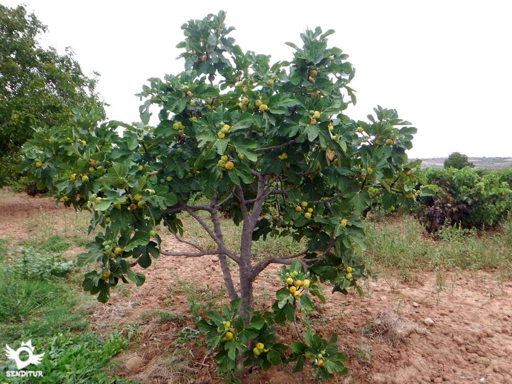
The union of the valleys of Jubera and Leza has resulted in fertile land around Murillo del Río Leza, where the Path of the orchards of Murillo runs. This route fitted between both rivers will take us to cross part of this land in which there are different cultures that are convenient between them contributing their special characteristics to an area that delimits the valley of the mountainous mountain ranges from which the rivers that join here descend. The vine, the olive trees, the almond trees are intermingled with the riverside orchards, each of them resisting to give prominence to the others.

The 8.2 km route takes us from Murillo de Río Leza and its imposing church of San Esteban Protomártir, an eye-catching example of the history that this village treasures, hidden in its entrails, towards the nearby Peñas del Leza and Jubera mountains, going up the course of the first one. A route that will allow us to discover the singularity of the climate that is given in this region marked by the wide valleys and the protection of the mountains that surround them, giving place to a nourished melting pot of cultures that are united around the route. The orchards on the banks of the river are giving prominence to the vineyards as we move away from the riverbed, and between them and sneaks a few olive trees that warn us of their early notoriety in the passage.

As we move away from the locality we find more clearly the silhouette of the mountains that delimit both valleys, the Jubera and the Leza, from which two castles served as unbeatable observatories from which to dominate and protect these fertile lands. On the way back and almost without realizing it, the vineyards have given some land to the olive groves and almond trees, an excellent raw material that serves as a base for no less excellent typical products of the area. In spring or autumn the landscape is tinged with a rich and varied color that adds to the already beautiful landscape formed by the valley and mountains, allowing us to enjoy the green and white tones of spring or the yellow, reddish and ochre of autumn.

The snow that visits the nearby mountains in winter makes this time no less interesting to travel calmly on the tracks that this route runs and that return us back to the town, but not before making a stop on the road at the chapel of Santa Ana, XVI century, one of the two with which has Murillo de Rio Leza, where the two rivers join to run together the short distance that separates them from the Ebro.
Legend has it that in the surroundings of Murillo del Río Leza the armies of the Cid Campeador had their camp in one of their bloody incursions in La Rioja, in which Logroño and the neighbouring localities were destroyed.
To get to Murillo de Río Leza we can do it through the LR-261 road that joins the town on one side with the N-232 at Agoncillo and on the other with the towns of the Jubera valley such as Ventas Blancas, Santa Engracia de Jubera or Robres del Castillo among others. At the same time, the LR-259 reaches Murillo de Río Leza from Logroño, passing through Villamediana de Iregua and continues from Murillo de Río Leza to Ausejo, communicating the town with Galilea, Corera and El Redal. Murillo de Río Leza has a metropolitan bus service with different lines, the M6 and M3, connecting it with Logroño and surrounding villages every day of the week and with frequent schedules. In Logroño is the bus station with national services, closer to Murillo. Once in the village we can find parking along the main street in its vicinity, then heading towards the confluence of the main street with Excideuil street, where the route begins.
Perfect route without a great distance nor hardly additional requirements, being almost in its totality on good tracks of earth. Attention especially in summer with the heat, there is hardly any shade where our friend can escape by an instate of the sun, we must also be attentive to the short stretch of road until entering the locality because it lacks sidewalks.
Without points of water in all the route, we cannot forget to replace the water that we take for him before leaving Murillo de Río Leza, for the rest and except especially hot days it would not have to have major problems.
The route goes through an area of orchards so it is usual to meet the pets that live there, although they are usually inside the enclosures they keep. We will also pass through hunting areas, so it is advisable to have it in the seasons in which this series of activities are developed.
In the section of the main street of Murillo de Río Leza (0h 00min) that leads to the nearby town of Ventas Blancas begins this route that will take us to go up the course of the river Leza.

It is past the crossroads with the road that leads to Villamediana de Iregua where soon we will find the street Excideuil, by which we must continue.

Following this street we will see ourselves going up a steep ramp that makes us gain height quickly, allowing us to contemplate part of the bank of the Leza that bathes the locality.

Leaving on both sides the different streets we came across, we arrived at the moment of turning off towards the limits of the locality. Almost at the same time that the buildings give way to orchards and fields, the asphalt track along which we were advancing gives rise to a comfortable dirt track that will accompany us for almost the entire journey.

We progressed by the wide track that crosses this fertile slope of the bank of the river Leza, which hides to our glance between the leafy vegetation that surrounds it.

There are not a few paths that we will leave behind as we move away step by step from the river, while we intersperse vineyards, orchards and recreation estates.

The track in perfect condition and well delimited leaves no room for doubt when we come across the various detours to which we should not pay attention for now.

Almost without realizing it, in the horizon, we can already contemplate the silhouette that form the natural park of the rocks of the Iregua, Leza and Jubera and that will accompany us in part of the route.

We continue advancing through the wide valley, in front of us, at the top of a promontory, are the ruins of an old corral, a moment in which after crossing a small watergate we will undertake a gentle ascent that will definitively separate us from the river Leza.

In this section we will cross again with other roads that maintain the course that the river traces, but we have to continue ascending, leaving the river behind us. The height that we gain in this part of the route allows us to observe the beautiful panoramic view that surrounds us, on one side Murillo of the Leza River and on the other the mountain range where the rivers come from among which we are boxed.

We continue with the route that for now maintains the progressive ascent, seeing how they begin to alternate the vineyards, the cereal farms and the olive groves. The riverside landscape is giving way to a plateau in which the different crops that occur in this land predominate, while we advance without paying any attention to how many paths we find.

Shortly after finishing the most accentuated ascent we find a crossroads where the track on our left seems to make us go backwards, we can follow this option although it will take us through cereal fields.

While if we continue a few meters more the track we are going, we will find a new detour, being this itinerary the one that will allow us to enter between olive and almond trees.

Both options come back together a little later. We go straight on and soon we find the way back (1h 10min), a perfect track on our left that leads us directly to a field of olive trees.

Not very far this new track comes to an end next to some almond trees, to be cut by another path that crosses it. Here our route turns to the left again to face us again towards the river without this time reaching its height.

A beautiful stretch awaits us with no more detours for the moment, crossing the different fields of cultivation that alternate with those of olives and almonds.

The path almost disappears in one of these fields, where the olive trees envelop us, making us think that the track that brought us here has already finished its layout.

Nothing could be further from the truth, since following the course we are taking among the olive trees, we will quickly realise that the path still resists disappearing, and almost at the moment, it recovers its marked profile.

Shortly after leaving behind us this farm, on our left, joins us the track that we had previously despised by taking us only through fields of cereal.

Already together we undertake the return towards the locality in which the landscape returns to be mainly dominating by the vineyards. Once again we will not have to turn off at any of the crossroads we come across as this track leads us directly to the outskirts of Murillo del Río Leza.

But before that we will have to pass by the Hermitage of Santa Ana (1h 50min) which indicates the proximity of the end of the route. Our track, shortly after passing the hermitage, ends at the road that joins Ventas Blancas with Murillo de Río Leza, where we are heading.

All that remains is to follow the course of the road that soon becomes the street where we started the journey. Following the main street we will arrive at the end of the route in the same point of Murillo de Río Leza (2h 00min) where we started it.
 Distance. 8.2Km
The place from where we start and finish the route marks the distance of the route.
 Time. 2:00h
Taking the road with the necessary calm to enjoy the environment that surrounds us, and given the few demands like ramps that we are going to find, this is the approximate time that will take us to make the route. Always taking as point of beginning and end of the route the beginning of the street Excideuil.
 Time of year
It goes without saying that the route and its relatively low physical demands allow it to be done almost any time of the year. Spring and autumn are the months when, at a landscape level, we can enjoy the route to the fullest, as we find in it the colourful contribution made by the vineyards, almond trees and olive trees, among others.
 Required equipment
Shoes and comfortable clothes, that if in consonance to the meteorological conditions, since the zone can get to be quite muddy if it has rained. Protection against the sun can not miss us because we will be at your mercy constantly, sunglasses, cap and sunscreen. The water, especially if it is summer, can not miss us. If we do not know the area will be of great help to us to take a map with the one that to be able to orient ourselves in case of doubt in some of the junctions with which we will find. Consult our list of material and equipment for hiking. Read more.
 Difficulty. Low
Physical
The relatively short distance, together with the slight unevenness to be overcome, make this an affordable route for those of us who used to walk. It is true that the sun in summer contributes to harden a layout that under normal conditions should be a pleasant walk. The ramps that we are going to have to save are short and not very demanding, so with the due calm they should not suppose a great problem.
Severity of the environment
The route runs at all times on tracks in quite good condition and as long as we do not get out of them we should not have greater complications than some areas somewhat more cobblestone than others. With rain or if it has rained in abundance shortly before, given the characteristics of the terrain we can find the roads tremendously muddy making it very difficult to move through them. Pay attention to the final stretch of road, although short and close to the town centre, it is still a road with hardly any hard shoulders and with more traffic than expected.
Orientation
The route is not signposted in any moment, therefore it is not other than to take the route well prepared from home and a map of the area to help us solve any doubt that might arise in any of the many roads that we will cross and that if we follow them can make us walk a few extra miles. Most of the tracks are usually covered by people in the area who take advantage of their good condition and the terrain through which they run for a pleasant walk. As a reference we can count on the fact that the route is embedded on one side by the river Leza and the road from Murillo to Ventas Blancas and on the other the other references are the line of mountains that form the rocks of Jubera and Leza and the town, beginning and end of the route.
 |
 |
 |
 |
 |
| 1-Murillo de Río Leza | 0:00h | 414m | 0Km | 30T 555551 4694457 |
| 2-Path back | 1:10h | 488m | 4.5Km | 30T 555548 4691061 |
| 3-Hermitage of Santa Ana | 1:50h | 448m | 7.4Km | 30T 555616 4693663 |
| 4-Murillo de Río Leza | 2:00h | 414m | 8.2Km | 30T 555551 4694457 |
Coordinates UTM Datum WGS84

 Slope: 346m
 Slope +: 173m
 Slope -: 173m
 Maximum altitude: 488m
 Minimum altitude: 414m

This sketch of the route is not made to scale nor does it contain all the information relating to the area, it is merely indicative.

![]()
This schematic with the path is approximate and has been created from the derived cartographic base © Instituto Geográfico Nacional "Cuadrante 204-4 1:25.000"
Senditur has manipulated the tracks to correct the aberrant points that may exist, caused by problems with the reception of the GPS signal. In any case the tracks are always approximate. SENDITUR encourages you to use the new technologies within your reach, using them as support and consultation in your activity, not basing the realization and orientation of the same only and exclusively on them, since they may see their functioning altered by very diverse causes, not functioning correctly and their indications may not be precise.


Ctra. Ventas Blancas S/N
941432372

¿Did you know that...
More than 500000 litres of olive oil are produced in La Rioja every year, and the first signs of olive cultivation in La Rioja date back to Roman times. In addition to the olive tree in La Rioja there is also an important production of almonds with which typical products of the region are prepared, including world-famous marzipan.
Don't miss out...
The Viewpoint of Cuesta of the Covacha, a privileged balcony from which you can enjoy a magnificent view of the town next to the two valleys that join in it. In addition, on days of good visibility we can contemplate the mountains that mark the beginning of the sierras that mark both valleys.


From the commitment of SENDITUR with Nature and the respect to the balance of the environment, SENDITUR urges you to travel in a responsible way, with low environmental impact and respecting at all times the Natural, Cultural and Social environment wherever you go.

Besides sharing with all of us your experience on the route we would be grateful if you could write to us to inform us of any erroneous or outdated information you may have found, or simply to let us know what you think at Thank you.
This route has been carried out in the field by SENDITUR on 12-10-2016. The route may vary greatly depending on the time of year, weather conditions and terrain, as well as the actions of third parties and the evolution suffered in the natural environment where it is located. All opinions, advice and/or assessments made by SENDITUR in their descriptions are for guidance only and are subject to and/or refer to the specific conditions of the specific day of the route, referring to that specific day, taken from trained people, with the appropriate experience and with a high level of physical and technical preparation as a reference, as well as correctly equipped.
All the times are approximate and take an orientative character, the stops have not been taken into account, no matter how small they are. All the information related to the route, texts, images, videos, maps, diagrams, tracks, towns, and places of tourist interest are published as a guide, and may not coincide with the current state of each place. Before undertaking any activity, assess your technical knowledge, your physical condition, find out about the weather and the variations that the route may undergo, equip yourself correctly, be prudent and responsible at all times, and do not exceed your capabilities. SENDITUR is not responsible for any misuse or inappropriate use of the comprehensive guides of its routes and/or publications as well as its electronic guides, nor for any variations in their descriptions for the aforementioned reasons, and recommends that everyone be responsible and prudent in carrying out the activity. We also encourage you to read books and specialised guides to complement the information described above.
Continue watching …


.jpg "Go to House of Sciences")
.jpg "Go to Castle of Clavijo")


