Welcome to SENDITUR.COM · paths · routes · tourism


Route of the Water of Berganzo
A natural site of incalculable value and great beauty
![]() Difficulty-Medium
Difficulty-Medium
![]() 2:45 h.
2:45 h.
![]() 8.8 km.
8.8 km.
A natural site of incalculable value and great beauty
![]() Difficulty-Medium
Difficulty-Medium
![]() 2:45 h.
2:45 h.
![]() 8.8 km.
8.8 km.
Under the protection of the steep Sierra of the Toloño, nestled in the peaceful valley of the river Inglares is the village of Berganzo in Alava. There are many notable trails that visit this beautiful town, including the Route of the Water of Berganzo, one of the best hiking routes in Alava.

The route along its 8.8 km takes us up the course of the Inglares River starting from the town of Berganzo. Hand in hand with the historic GR 1 path as it passes through this land, we will take the first steps of our itinerary until we say goodbye to it and set out in search of the numerous waterfalls that await us. The Inglares River, in its course from the town of Peñacerrada to Berganzo, crosses a considerable slope, leaving behind waterfalls and rapids that are the unbeatable home for European otters and minks, true jewels of this river.

But without a doubt, of all the waterfalls we will visit on this route, it will be the waterfall of Las Herrerías, or of the Inglares, that will captivate us the most. After having a good time contemplating it, the itinerary ascends in search of the channel that in its day was carved by the workers to supply water to the hydroelectric power station of Berganzo. The route takes us through this channel that dates back to 1897 and that undoubtedly makes our return to Berganzo more enjoyable, but not before stopping to contemplate the valley where it is dominated by the unmistakable silhouette of the Castle of Ocio or Lanos that has dominated the entrance to this fertile valley for centuries.

For those who, for whatever reason, cannot follow the entire route, but do not want to miss the spectacular Las Herrerías waterfall, just at the height where the route crosses the road, there is a small area where you can park your vehicle and walk the short distance between the waterfall and the road, thus visiting one of the major attractions of the Route of the Water of Berganzo.
To get to Berganzo we can do it either from Zambrana or from the town of Peñacerrada following the road that joins both towns, as this road passes through Berganzo. Once there, next to the road, we will find, already in the middle of Berganzo, a couple of car parks where we can park our vehicle. The car park is located on the outskirts of the town in the direction of Peñacerrada, from where this route starts. Of not finding parking in these two places, if we crossed the river leaving behind the parking from where the route begins and we went towards the church also we will have some that another zone of parking. Although generally and given the number of hikers who visit this route, access to the village is prohibited, forcing us to park our vehicle in the car park that we will find on the outskirts of Berganzo as we arrive from Zambrana. Parking in this car park is not free and you will have to make a reservation in advance and pay via an app to be able to park.
Nice walk for our friend who should not be too worn out, as long as his physical condition is good.
Usually in this route the water for him to drink is not a problem, but it is important to be careful to avoid scares if he gets into the river, on the other hand in the channel is not very advisable to let him get in.
Some of the species of animals that live in this area are in danger of extinction, it will not be easy to let them be seen, but neither should we get distracted.
The small parking area next to the road to Berganzo (0h 00min) in the direction of Peñacerrada, on the way out, marks the starting point for this interesting hiking route in Alava. If we leave from the farthest car park we will have to follow the perfect path that will take us to cross the road, to enter Berganzo following one of its accesses. Until we reach the parking of the Uriarte Square, crossed the river. From there we will go up the Uriarte street, which, together with the GR 1, will take us to the real beginning of the route.

Just before crossing the Inglares River a sign informs us of the route we are about to start. Poster that we also have to find in all the parking areas from where we can start the tour.

At once we leave behind the streets of Berganzo to join the itinerary of the illustrious GR 1, which will accompany us in this first part of our route. Illustrious path through which those who could not park so close to the beginning of our route will arrive here.

All together now, we then began to ascend without too much effort the valley through which the Inglares River flows, the true protagonist of this itinerary.

We follow, at least for the time being, an old cart track, which struggles with the vegetation to maintain its width. The GR 1 marks alternate with the blue and white marks of the Water Route we are following.

We leave behind us some detours, without them making us doubt the itinerary to follow.

Soon it is time to abandon the route of the GR 1 that continues towards Peñacerrada, to go in search of the Inglares, still hidden.

We will only have the blue and white marks as guides of our route. Soon the river begins to show itself as if it wanted to warn us of what is to come.

We start wading, thanks to small footbridges, the streams that in this part of the valley nourish the Inglares River with water.

The broad trail we are following leaves little doubt as to the direction we should take.

On our left we leave an old wooden bridge that allows us to cross the river, which we should not do.

Soon after, the vegetation gives way to a green meadow that we must cross. It is from this point that we will find, as we advance, the different trails that allow us to approach the multiple waterfalls that are concentrated here.

Our trail runs through this area, leaving many detours on its left to take us to the meeting point of the road between Berganzo and Peñacerrada.

A road that we will have to cross carefully in order to continue with the route.

This part of the route skirts a farm without us having noticed that the Inglares River now flows to our right.

The wide trail leads us to a crossroads where a post on the route invites us to radically change direction while in front of us we will see a bridge.

If we cross the bridge and follow the trail that goes up the riverbed we will soon find the impressive Inglares waterfall (1h 15min), but after enjoying this magnificent spot we will have to return on our own steps to resume the route.

A route that takes us to a new post that if followed leads us to another of the points from where we can contemplate this beautiful waterfall.
After visiting these two viewpoints of the Inglares, next to the second of the posts through which we have passed begins the path that will take us back to Berganzo.

Now it is our turn to tackle the most sloping section of the entire route. Luckily, this hard climb does not last long and soon reaches its end.

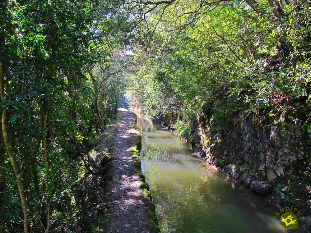
An end that is marked by the presence of the channel that we will have to follow from now on. This part of the route runs alongside the canal, following the quiet route that it draws, cutting the side of the mountain.

At the moment there are few occasions when we will be separated from the water channel, only when it disappears to save some bend in the path. A separation that barely lasts a few meters to rejoin our paths.

The route presents hardly any difficulties and the changes in the landscape we encounter are appreciated. We will not have many occasions to cross with other roads or trails, and in no case should we be separated from the water channel for long.

Some areas of the route are somewhat narrower than normal forcing us to pay more attention especially if they are wet.

Later on the channel begins to hide more often indicating the proximity of the end of this part of the Route of the water of Berganzo.

After a while and without the presence of the water channel, our trail forks and we must follow the option on the left.

We then begin the rapid descent that will take us to the village of Alava from where we set off.

Our trail reaches its end when it meets a path that ascends from the nearby town of Berganzo.

We will continue to descend along this path, which will leave us at the doors of the car park from which we start the Route of the Water of Berganzo (2h 45min). If we are not lucky enough to park there, we will have to go up the road towards Zambrana, until we find the first street on our left, where we can return to the other parking areas.
 Distance. 8.8Km
To this figure we will have to add the distance that separates Berganzo from the car park, approximately 2 km more.
 Time. 2:45h
The obligatory stops at the different waterfalls we will go through will undoubtedly lengthen this figure even by 1h or more. We will also have to add up the time it takes for the extra itinerary between the parking area and the actual start of the route, an additional 20 minutes if we come out of the farthest.
 Time of year
It is certain that the volume of the Inglares river conditions enormously the showiness of this route of hiking, but the vegetation that will surround to us throughout the route also contributes its special touch to the landscape that we have to find.
 Required equipment
The relative simplicity of the itinerary can make us fall into the error of not equipping ourselves correctly. The mud and the slipperiness of some areas can put us in trouble of not wearing the right shoes, at least some hiking shoes. Although we will pass by several fountains, as they are not treated, it is advisable to take some water as well as food. Of course you can't forget your camera and tripod if you want to take some good shots. Consult our list of material and equipment for hiking. Read more.
 Difficulty. Medium
Physical
Neither the distance nor the unevenness that the route accumulates should put us in difficulty, as long as we are used to doing this type of hiking.
Severity of the environment
Pay attention to the slips with the mud and the wet stones, be careful when crossing the road, and above all do not get distracted in the stretch that coincides with the water channel since it has more depth than it seems. In addition we will pass through somewhat narrow areas and constantly have to our left the hillside of the mountain.
Orientation
Signposted at all times, the most difficult thing will be not to skip any of the detours that bring us closer to the waterfalls, as these are not signposted. Neither will we find too many junctions that may complicate us. The accesses from the different car parks are also perfectly marked.
 |
 |
 |
 |
 |
| 1-Berganzo | 0:00h | 577m | 0Km | 30T 517815 4721924 |
| 2-Road | 1:05h | 660m | 2.9Km | 30T 520317 4721861 |
| 3-Waterfall of the Inglares | 1:15h | 662m | 3.2Km | 30T 520412 4721747 |
| 4-Water channel | 1:30h | 708m | 3.7Km | 30T 520478 4721747 |
| 5-Berganzo | 2:45h | 577m | 8.8Km | 30T 517815 4721924 |
Coordinates UTM Datum WGS84

 Slope: 316m
 Slope +: 158m
 Slope -: 158m
 Maximum altitude: 708m
 Minimum altitude: 577m

This sketch of the route is not made to scale nor does it contain all the information relating to the area, it is merely indicative.

![]()
This schematic with the path is approximate and has been created from the derived cartographic base © Instituto Geográfico Nacional "Cuadrante 170-1, 25.000"
Senditur has manipulated the tracks to correct the aberrant points that may exist, caused by problems with the reception of the GPS signal. In any case the tracks are always approximate. SENDITUR encourages you to use the new technologies within your reach, using them as support and consultation in your activity, not basing the realization and orientation of the same only and exclusively on them, since they may see their functioning altered by very diverse causes, not functioning correctly and their indications may not be precise.


Una ruta muy bonita.

Una ruta de senderismo preciosa, me encanto, muy recomendable también para ir con los niños para ellos toda una aventura.

An emblematic place where devotion and tradition come together


According to historians, Alava's best-preserved fortified complex

¿Did you know that...
The Berganzo hydroelectric plant is one of the oldest in the region, and is still in operation today thanks to the water that reaches it through the canal, although its management is automated. There are images and information about the construction of the canal in Berganzo and in the Zambrana archive.
Don't miss out...
The castle of Ocio, also known as the castle of Lanos, is one of the medieval fortresses that in these lands controlled the border between the kingdoms of Navarre and Castile. Through this fortress passes the route of the castles that through its 14 km runs the most representative castles and fortresses of the region.


From the commitment of SENDITUR with Nature and the respect to the balance of the environment, SENDITUR urges you to travel in a responsible way, with low environmental impact and respecting at all times the Natural, Cultural and Social environment wherever you go.

Besides sharing with all of us your experience on the route we would be grateful if you could write to us to inform us of any erroneous or outdated information you may have found, or simply to let us know what you think at Thank you.
This route has been carried out in the field by SENDITUR on 16-02-2019. The route may vary greatly depending on the time of year, weather conditions and terrain, as well as the actions of third parties and the evolution suffered in the natural environment where it is located. All opinions, advice and/or assessments made by SENDITUR in their descriptions are for guidance only and are subject to and/or refer to the specific conditions of the specific day of the route, referring to that specific day, taken from trained people, with the appropriate experience and with a high level of physical and technical preparation as a reference, as well as correctly equipped.
All the times are approximate and take an orientative character, the stops have not been taken into account, no matter how small they are. All the information related to the route, texts, images, videos, maps, diagrams, tracks, towns, and places of tourist interest are published as a guide, and may not coincide with the current state of each place. Before undertaking any activity, assess your technical knowledge, your physical condition, find out about the weather and the variations that the route may undergo, equip yourself correctly, be prudent and responsible at all times, and do not exceed your capabilities. SENDITUR is not responsible for any misuse or inappropriate use of the comprehensive guides of its routes and/or publications as well as its electronic guides, nor for any variations in their descriptions for the aforementioned reasons, and recommends that everyone be responsible and prudent in carrying out the activity. We also encourage you to read books and specialised guides to complement the information described above.
Continue watching …


.jpg "Go to Valderejo Natural Park")
.jpg "Go to Izki Natural Park")


