Welcome to SENDITUR.COM · paths · routes · tourism


![]() Difficulty-Moderate
Difficulty-Moderate
![]() 3:10 h.
3:10 h.
![]() 9 km.
9 km.
![]() Difficulty-Moderate
Difficulty-Moderate
![]() 3:10 h.
3:10 h.
![]() 9 km.
9 km.
The special location of the Toloño, partly separating La Rioja from the Basque Country, also makes it a natural border between the Mediterranean and Atlantic climates. This marked difference can be clearly seen in the vegetation that covers both slopes, holm oaks and pine forests in the south and leafy beech forests in the north, as well as in the crops, which are well differentiated from one orientation to the other, mainly vineyards in the south, while on the north side it is the cereal and grasses that predominate. The climb to Toloño from San Ginés becomes a demanding march whose reward far outweighs the effort involved in climbing this beautiful mountain.

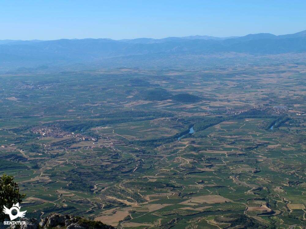
The route with 9 km in total takes us from the Park of San Ginés's hermitage to face a worked ascent surrounded by holm oaks and pine groves that will contribute us part of their protective shade. The height that the route quickly gains allows us to get a small idea, with every obligatory stop to recover our breath, of the spectacular environment that surrounds this mountain. The valley of the Ebro is step by step almost hidden from us by the luxuriant forest that surrounds us. The first cliffs that we see rise up imposingly above us as if resisting to let ourselves be overtaken by them. The hermitage of El Humilladero marks the end point of the forest that leaves a deserted hillside from which we can contemplate without obstacles what we have left behind. The valley of the Ebro stretches out before us, allowing us to contemplate the whimsical meanders that it draws in its tranquil course towards the Mediterranean. On its banks lie such towns as Labastida, Briñas and Haro, among which we can identify.

We leave behind the battered hermitage to continue the ascent in search of the passage through which we will save the enormous rocks that make up the Sierra of the Toloño, whose summit is still hidden from our eyes. The first remains of the Monastery of Santa María de Toloño, or Our Lady of the Angels as it is also known, surprise us in the midst of our efforts to overcome the slope that separates us from it. Its ruins tell us part of its history, which goes from the small chapel that used to be here to the remains of this once prosperous monastery surrounded by precious snowdrifts with which to trade, which saw how it gradually fell into disgrace until its destruction in the first Carlist War. From here we decided to climb to the summit of the Toloño, from where we will enjoy the privileged views that cover this area of the Ebro valley, delimited by the unmistakable silhouette of the San Lorenzo in the La Demanda mountain range, but also of the southern area of Alava and the picture of the Basque Mountains and their mythical peaks. We will also visit some of the peaks that surround the Toloño, such as the one that houses its geodesic vertex, from which we will see part of the Rioja Alavesa.

Another of these is the Castle Peak, an imposing rock that dominates the entire prairie or Peak of the Twelve, from where we will enjoy the panoramic view of the Mounts Obarenes, the Miranda de Ebro area of Burgos and one of the different perspectives that this mountain range of Toloño offers, to return again to the San Ginés Park saying goodbye for now to the unmistakable Toloño.
Legend has it that even today, on stormy days, the ancient bells of the Monastery of San Maria de Toloño can be heard ringing in the surroundings of Toloño. They resound in the strong wind of the storm, serving as a reference for disoriented mountaineers who are lost in the fog to find the right path.
Labastida can be reached by following the N-232a from nearby Briñas on the N-124 between Vitoria and Haro. Also from Haro, more specifically from the Barrio de las Bodegas, the regional road linking the two towns starts. This same N-232a, or as it is also known, the A-124, reaches Labastida from Logroño, passing through Laguardia, Samaniego and the vicinity of San Vicente de la Sonsierra, among other towns. Labastida also has a bus service that connects it with Logroño, Vitoria, Bilbao and Haro, as well as with nearby towns. Once in Labastida, you will find the street that leads to the track that leads to the San Ginés Hermitage, at the entrance to the N-232a when you arrive from Briñas. This street leads directly to San Ginés Avenue, which takes us out of the town. Leaving the first fork in the road on our left, it takes us along a paved track to the San Ginés Hermitage Park, where we will find a large car park to leave our vehicle.
Interesting route, quite demanding because of the slope to overcome, is the stone of some areas that can lead to greater problems for our partner, but being attentive and guiding him through the right place will avoid possible injuries to their legs. The barbed wire is another of the factors with which we will have to be attentive since we can be found with hidden pieces by the vicinity of the fence.
The absence of water points along almost the entire route and the demand of the unevenness added to the heat that we can find at certain times of the year, forces us not to leave the water for our friend and replace it if we need it in the fountains of the San Ginés park.
Cattle, horses, cows... are a regular feature of the upper meadow, although during the ascent it will not be very normal to come across cattle as they are usually more on the north side. Nor can we rule out other pets that like us are enjoying this magnificent mountain very busy in summer.
The San Ginés Hermitage Park (0h 00min) at the base of the southern face of the Toloño serves as the starting point for this route.

More specifically, it is on the opposite side of the car park, as we reach it, where the track we have to follow begins.

A few metres from the start we come to a crossroads where it is the one on our right that we must continue along.

A solitary cement cabin, added to the unmistakable silhouette of the mountain, indicates that we are on the right track. The track is gradually gaining in slope without demanding too much effort for now, while we leave behind a first detour.

Soon we find ourselves at another crossroads where either of the two options we take is correct as they both come together again somewhat later. The one on the right takes us along the track, making us travel a little further in exchange for having a slightly gentler slope.

The one that seems to go straight soon becomes a trail that shortens some of the distance, bringing more slope to the route. This type of shortcuts are common on the route, making us doubt in many cases the way to go. A few meters after the unification of both options, we find another detour, this one to follow without any doubt.

To our right begins a long and steep trail that takes us right into the true ascent. The clearly defined trail guides us through the mountain, following its course at all times, which at times and due to its condition, looks like a dry torrent of water.

We quickly began to gain height, leaving behind us another link to the track that brought us here.

Soon our trail begins to gain width to become a stony path as we reach a new junction. Without detours we continue on, now along this steep path that borders the mountainside, allowing us to contemplate for the first time the cliffs that separate us from the topmost meadow of the Toloño.

Our path continues to demand a considerable effort from us in order to move forward at the same time as it meets other paths that we should not follow. After a deceptive rest on the slope, we find ourselves in front of a real wall where the path seems to become almost as vertical as the rocky walls in front of us.

Halfway up the ramp, when it gets even steeper, we reach another junction where both options are correct. The slightly shorter one on the right continues the ascent at an even steeper angle. Meanwhile, the one on the left, in exchange for going a few more metres, gives us a slightly less demanding route by drawing a long zigzag to cross this stretch.

At the same point where the two roads meet again we find another detour or shortcut. As it could not be otherwise the choice of the road is somewhat longer and maintained in the effort. On the contrary, the path that begins on our left shortens the route, although in this case without demanding too much of us until almost the end of the route.

Once again, with both options unified, we continue with the laborious ascent to cover the already short distance that separates us from the Hermitage of the Humilladero (0h 55min), which we reach by taking a trail that saves the earth slope that marks the road.

It is in this hermitage where our route joins one of the variants that ascends from the vicinity of Rivas de Tereso, another of the many options that the Toloño has to climb to it. From here we will find the route marked by white and yellow marks, although the well-defined path almost to the summit, leaves no room for doubt.

Once again, there are two options available to us and, as usual, the short cut on our right hand side shortens the distance in exchange for a greater slope.

This section continues with the hard climb that we had already been enduring, now following a path that alternates areas in fairly good condition with others that are somewhat bare, but do not pose any problems.

The absence of trees that provide us with some shade makes this stretch a hard climb if we add the heat of the sun to the slope.

Soon the route changes direction, heading more clearly in search of the highest part of its route, allowing us to see the remains of the hermitage of the Virgen del Toloño. Not without effort we reach the height of the Monastery of Santa Maria del Toloño (1h 15min) as it is also known to the hermitage of the same name.

Here the slope practically disappears leaving us to contemplate the spectacular surroundings.

With the monastery on our left, we go towards the gate that allows us to cross the wire fence that delimits the meadow, to continue towards our objective, which we already see in front of us.

We cross the meadow trying to discover a large stone with a red and white mark, surrounded by bushes, where the trail to the summit begins.

Ahead we have a short but demanding route winding through the bushes while following a battered path marked by stone markers.

We quickly find ourselves on a new plain with the final climb that gives access to the summit in front of us, while to our right we observe the geodesic vertex to which we will then head.

A simple climb allows us to reach the summit of Toloño (1h 30min) without any problem, from where we can enjoy the magnificent views that this mountain offers. Once we have conquered this peak, we descend the short rocky section, to head towards our next objective from which a short distance separates us.

A short descent through an area of dense vegetation and the subsequent gentle climb takes us to the Geodesic Vertex of the Toloño (1h 35min) from where we can see the eastern part of the Ebro Valley more clearly. Once we have spent the necessary time on this peak, we will follow our steps towards the meadow where the remains of the monastery are located.

The panoramic view during the descent allows us to scrutinize the mountain and discover the multiple paths that lead to each cliff that form the Sierra of the Toloño, each one with its different demands to be climbed.

Once in the meadow we head towards our next peak without paying attention to the multiple paths that seem to lead us to it, we advance looking for the comfort of it following a, more and more clear, path marked by the yellow and white marks that brought us here, next to some wooden posts that indicate another of the routes that cross these mountains.

Almost at the end of the meadow, when the path we follow forks in two, which if followed would lead us into the impressive beech forest, our route follows the one on the left for a moment and then turns directly towards the mountain we are about to climb.

A short climb ahead, following a winding path that winds through the bushes on the mountainside. Once again we will be forced to cross the fence that delimits the meadow, at the same time that we are joined by the different paths that reach this place.

The only thing left to do is to cover the short, stony distance that separates us from the summit of Rock of the Twelve (2h 10min), a summit that in exchange for a simple ascent, at least for this slope, offers us unbeatable panoramic views that invite you to spend a good time enjoying them.

The only thing left to do now is to retrace our steps, following the meadow in the direction that suits us best, to reach the ruins of the monastery, then heading towards the Hermitage of El Humilladero and from there along the steep path to the Park of the Hermitage of San Ginés (3h 10min), where this route ends.
 Distance. 9Km
Our route through the Toloño plateau will affect the distance of the route.
 Time. 3:10h
The time we will need to do this route is marked in part by the hard climb we have to face and the time we spend on it, although the relative short distance of the route allows us, if we have the necessary time, to take it easy so as not to suffer more than necessary. Contrary to what it might seem, the descent for an inexperienced person, can take longer than expected when having to face steep ramps of loose stone.
 Time of year
It is in these two seasons that the environment offers us the most spectacular, thanks to the numerous variations in the colours of the forests or the vineyards that surround this mountain. The summer guarantees us good weather in exchange for hardening a little more the already demanding route. The harsh winters that this mountain endures change its character making us ready to meet some demanding conditions that undoubtedly bring a special beauty to the mountain at the cost of increasing its difficulty.
 Required equipment
Always adapting our equipment to the weather conditions and the time of year we are, the route allows us to use light footwear such as trekking shoes. We must not forget that we are in an area where the changes in weather conditions are very fast and we can start the day with good weather and almost without realizing it, we are in the middle of a strong storm. The great amount of routes that cross the area makes that, as it should not be otherwise, we take a map of the place and the compass in case we could need it. Otherwise the camera, water and food along with the usual protection against the sun must be part of our adventure partners. Consult our list of material and equipment for hiking. Read more.
 Difficulty. Moderated
Physical
Without a doubt, it is the difference in level to overcome, together with the short distance in which it is overcome, that makes this a demanding route in principle, although by taking it easy on the hard ramps we can win more than by getting involved in a struggle to advance more quickly. Without a doubt, we must keep our strength up for the descent which, due to its unevenness, will demand a greater effort than we could have expected. The heat may be another component that makes the route harder. The area supports high temperatures in summer and the route runs almost entirely on the southern face of the mountain exposed to the sun all day long.
Severity of the environment
A fairly broken pavement in some areas or with a lot of loose stone on the steeper ramps requires us to be careful, especially on the descent, to avoid slips and falls. In the top areas we must not forget that we are surrounded by vertical cuts, although these are wide enough so that this is not a problem, provided that we do not expose ourselves more than necessary. The climb to the summit of El Toloño on the southern hillside is simple, with wide foot pegs that make it easy to climb up without being exposed to a large drop. We will pass through areas where there have been landslides on the mountainside where the path created is wide but requires greater attention so as not to slip when passing them. In the event of rain, the terrain will be extremely muddy, making the route more difficult and dangerous than in normal conditions.
Orientation
Without a clear signposting, it is the obvious trail to follow that leaves little doubt as to which path to choose. In the first short cut the marks send us along the path, while in the second detour, which we must follow, the post that indicates it is hidden in the crossroads that we find as soon as we take the path. There are many paths and roads that cross this area so if we leave the route we may find ourselves with a few extra kilometres to return to the starting point. The fog and storms are often visitors to this mountain because of its location, we may find some very reduced visibility conditions that make it very difficult to orient ourselves.
 |
 |
 |
 |
 |
| 1-Park of San Ginés | 0:00h | 641m | 0Km | 30T 517786 4717117 |
| 2-Hermitage of the Humilladero | 0:55h | 1062m | 2.5Km | 30T 518555 4718667 |
| 3-Hermitage of Toloño | 1:15h | 1195m | 3.1Km | 30T 518963 4718815 |
| 4-Toloño | 1:30h | 1277m | 3.5Km | 30T 519352 4718964 |
| 5-Geodesic vertex | 1:35h | 1263m | 3.8Km | 30T 519530 4718776 |
| 6-Rock of the Twelve | 2:10h | 1255m | 5.1Km | 30T 518512 4719167 |
| 7-Hermitage of Toloño | 2:20h | 1195m | 5.7Km | 30T 518963 4718815 |
| 8-Hermitage of the Humilladero | 2:30h | 1062m | 6.3Km | 30T 518555 4718667 |
| 9-Park of San Ginés | 3:10h | 641m | 9Km | 30T 517786 4717117 |
Coordinates UTM Datum WGS84

 Slope: 1416m
 Slope +: 708m
 Slope -: 708m
 Maximum altitude: 1277m
 Minimum altitude: 641m

This sketch of the route is not made to scale nor does it contain all the information relating to the area, it is merely indicative.

![]()
This schematic with the path is approximate and has been created from the derived cartographic base © Instituto Geográfico Nacional "Cuadrante 170-1 1:25.000"
Senditur has manipulated the tracks to correct the aberrant points that may exist, caused by problems with the reception of the GPS signal. In any case the tracks are always approximate. SENDITUR encourages you to use the new technologies within your reach, using them as support and consultation in your activity, not basing the realization and orientation of the same only and exclusively on them, since they may see their functioning altered by very diverse causes, not functioning correctly and their indications may not be precise.


No hace mucho que estuve aquí subiendo del pueblo de Berganzo, aunque no es la primera vez ya que en 2011 también subí desde Berganzo haciendo otra ruta distinta. http://alavaentusbotas.blogspot.com.es/2011/08/triple-ascension-al-tolono-3-parte.html Aparte de la niebla en lo alto todo magnifico.


Magnificas montañas las de sierra Cantabria

Romanesque jewel from La Rioja

An emblematic place where devotion and tradition come together


Avenida Miranda, 1
941312737

¿Did you know that...
For years and even today there has been a lot of controversy with the actual location of the Toloño's summit, even the typical mailboxes that crown each mountain have been pointing out the Toloño's summit on different peaks from those surrounding the monastery's meadow, like for example in Peña las Doce. Currently, in the IGN's topographical maps, the summit considered to be the Toloño is named Peña del Agujero and it is the geodesic vertex that is attributed to be the summit of the Toloño.
Don't miss out...
The impressive beech forest that surrounds the Toloño on its northern slope, we can go into it to get to know it when we go to the Peña las Doce peak. It is on this side of the meadow where we can follow for a few meters a couple of trails that reach here from the opposite side of the mountain through the lush forest.


From the commitment of SENDITUR with Nature and the respect to the balance of the environment, SENDITUR urges you to travel in a responsible way, with low environmental impact and respecting at all times the Natural, Cultural and Social environment wherever you go.

Besides sharing with all of us your experience on the route we would be grateful if you could write to us to inform us of any erroneous or outdated information you may have found, or simply to let us know what you think at Thank you.
This route has been carried out in the field by SENDITUR on 18-10-2021. The route may vary greatly depending on the time of year, weather conditions and terrain, as well as the actions of third parties and the evolution suffered in the natural environment where it is located. All opinions, advice and/or assessments made by SENDITUR in their descriptions are for guidance only and are subject to and/or refer to the specific conditions of the specific day of the route, referring to that specific day, taken from trained people, with the appropriate experience and with a high level of physical and technical preparation as a reference, as well as correctly equipped.
All the times are approximate and take an orientative character, the stops have not been taken into account, no matter how small they are. All the information related to the route, texts, images, videos, maps, diagrams, tracks, towns, and places of tourist interest are published as a guide, and may not coincide with the current state of each place. Before undertaking any activity, assess your technical knowledge, your physical condition, find out about the weather and the variations that the route may undergo, equip yourself correctly, be prudent and responsible at all times, and do not exceed your capabilities. SENDITUR is not responsible for any misuse or inappropriate use of the comprehensive guides of its routes and/or publications as well as its electronic guides, nor for any variations in their descriptions for the aforementioned reasons, and recommends that everyone be responsible and prudent in carrying out the activity. We also encourage you to read books and specialised guides to complement the information described above.
Continue watching …


