Welcome to SENDITUR.COM · paths · routes · tourism

![]() Difficulty-Low
Difficulty-Low
![]() 0:45 h.
0:45 h.
![]() 1.8 km.
1.8 km.
![]() Difficulty-Low
Difficulty-Low
![]() 0:45 h.
0:45 h.
![]() 1.8 km.
1.8 km.
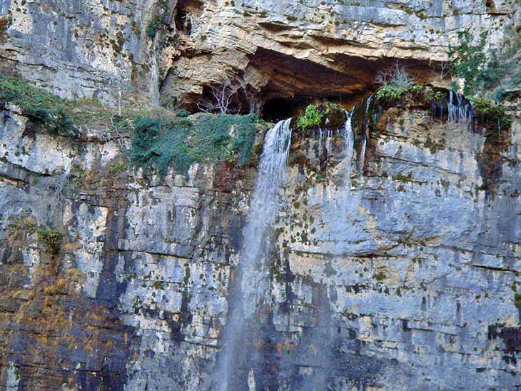
The province manchega of Albacete is home to countless natural sites of great beauty, some of which are undoubtedly among the most beautiful in Spain. This is certainly the case of the Source of the River Mundo and its waterfalls, which are among the most spectacular and beautiful you can visit on the peninsula. Located within the Los Calares del Mundo y de la Sima Nature Reserve. This area is characterised by its karst formations which, together with the water, give rise to a beautiful ensemble formed by the Cave of the Spurts, where the Mundo river rises, and the waterfalls with which the river overcomes the vertical cliffs that separate it from the bottom of the valley.
The Source of the River Mundo is located within the municipality of Riópar. To get there, follow the CM-3204 road between Riópar and Siles. Just 6 kilometres from Riópar we will find the turn-off that leads to the source.
The main car park, which is located approximately 2 km from the road, has a capacity limited to 100 cars and 6 buses, so if you don't arrive early it is easy to find it full. Depending on the time of year this car park may also be closed, and it is not uncommon to have to pay €4 to park there. If the car park is full or closed, there is another parking area in the middle of the road, at the Port of Arenal. From there there is a signposted path that will take you to the second car park without any problems, although you will have to walk a little over 3 km.
The flow of the spurts of the river Mundo are what mark the best time to visit this place. Make no mistake, the site is spectacular all year round, but obviously the greater the flow, the greater the spectacle. As you can imagine, it is after the rainy season and the thaw that the waterfalls will offer us all their beauty, while in summer with the drought it is very likely that they carry very little water, just a few trickles. But undoubtedly the best time to visit the source of the Mundo river is when the natural phenomenon known as The Blowout occurs. This phenomenon occurs on rare occasions throughout the year and is a consequence of the accumulation of water in the underground galleries of the mountain, mainly due to snowfall. Such a large quantity of water generates a kind of explosion that expels it forcefully to the outside, creating a real spectacle.
Once we are at the main parking place (0h 00min) we see the signs that mark the beginning of a simple route, suitable for the whole family, that takes us to the waterfalls of the river Mundo. The route takes us across a small brook to meet the river. We quickly reach the Calderetas, small pools of water that brighten up this part of the route. From here we can already see the great waterfall of the Mundo river towards which we are heading. The most demanding part of the route awaits us, but with the necessary calm it should not be a problem. Afterwards the different viewpoints (0k 30min) and footbridges await us, which allow us to enjoy this spectacle of nature.

Source of the Mundo river-CC/Esteban Javier Millan Rivas
Source of the Mundo river-CC/Rafael Tello

Mundo river-CC/Esteban Javier Millan Rivas

Once you have enjoyed this spot, you have to retrace your steps back to the parking place (0h 45min). We can also take the track that is accessible to people with reduced mobility, which will leave us on the access road to the car park, in the middle of the bend just before it descends to the car park. The more intrepid can dare to climb up to the Cave of the Spurts, the real place where the Mundo river rises.
To be able to do this route we have to apply for a special permit at least 10 days in advance.
We also have two possibilities, either we do the route with a company accredited by the council, or we do it on our own, in which case we must prove the necessary knowledge and have insurance, initially federative insurance. This is due to the number of accidents that have occurred on this section, a route whose difficulty and exposure requires experience in this type of terrain.
1-Although the route initially has no major complications, there are areas with quite a lot of vertical drops, where there have already been a few accidents due to overconfidence.
2-Wear footwear suitable for hiking on slippery terrain and clothing that will protect you from the spray generated by the waterfall as it descends steeply.
3-Do not leave the signposted routes, there are specific picnic areas to speed up visits on busy days, so you are only allowed to eat there.
4-There is a checkpoint at the beginning of the road leading to the main car park, where you will be informed of the waiting times for access to the car park, so you can decide whether to park in the Port of Arenal car park.
 |
 |
 |
 |
 |
| 1-Parking | 0:00h | 1040m | 0km | 30S 548990 4256554 |
| 2-Viewpoints | 0:30h | 1120m | 0.9Km | 30S 549152 4256005 |
Coordinates UTM Datúm WGS84

.png) Distance: 1.8Km
Distance: 1.8Km
.png) Time: 0:45h
Time: 0:45h
.png) Difficulty: Low
Difficulty: Low
 Slope: 180m
 Slope +: 90m
 Slope -: 90m
 Maximum altitude: 1120m
 Minimum altitude: 1040m

![]()
This schematic with the path is approximate and has been created from the derived cartographic base © Instituto Geográfico Nacional "Cuadrante 866-1 1:25.000".

Una maravilla, me encanto.

¿Did you know that...
The Blowout phenomenon is not known to occur in any other cave of karstic origin. During this period, the waterfall multiplies its flow by 100 times, flooding the entire area behind it.
Don't miss out...
The nearby town of Alcaraz, which has a rich cultural and artistic heritage, including its castle, the church of Santísima Trinidad and Santa María, its Main Square and the Tardón Tower.


From the commitment of SENDITUR with Nature and the respect to the balance of the environment, SENDITUR urges you to travel in a responsible way, with low environmental impact and respecting at all times the Natural, Cultural and Social environment wherever you go.

Besides sharing with all of us your experience on the route we would be grateful if you could write to us to inform us of any erroneous or outdated information you may have found, or simply to let us know what you think at Thank you.
Route information updated on 29-11-2020. The route may vary greatly depending on the time of year, weather conditions and terrain, as well as the actions of third parties and the evolution suffered in the natural environment where it is located. All opinions, advice and/or assessments made by SENDITUR in their descriptions are for guidance only and are subject to and/or refer to the specific conditions of the specific day of the route, referring to that specific day, taken from trained people, with the appropriate experience and with a high level of physical and technical preparation as a reference, as well as correctly equipped.
All the times are approximate and take an orientative character, the stops have not been taken into account, no matter how small they are. All the information related to the route, texts, images, videos, maps, diagrams, tracks, towns, and places of tourist interest are published as a guide, and may not coincide with the current state of each place. Before undertaking any activity, assess your technical knowledge, your physical condition, find out about the weather and the variations that the route may undergo, equip yourself correctly, be prudent and responsible at all times, and do not exceed your capabilities. SENDITUR is not responsible for any misuse or inappropriate use of the comprehensive guides of its routes and/or publications as well as its electronic guides, nor for any variations in their descriptions for the aforementioned reasons, and recommends that everyone be responsible and prudent in carrying out the activity. We also encourage you to read books and specialised guides to complement the information described above.
Continue watching …


