Welcome to SENDITUR.COM · paths · routes · tourism

![]() Difficulty-Low
Difficulty-Low
![]() 1:40 h.
1:40 h.
![]() 5.4 km.
5.4 km.
![]() Difficulty-Low
Difficulty-Low
![]() 1:40 h.
1:40 h.
![]() 5.4 km.
5.4 km.
The Bernesga Valley, in the Mountain Central Leonesa, has been, like so many other valleys in the area, a mining region. Today this industrial activity has come to an end in this part of the province of León, but it has left its mark on the people and the landscapes. These landscapes are home to priceless treasures such as the Faedo of Ciñera and the Gorges of Villar. The route that runs through this spectacular beech forest, considered one of the best preserved in Spain, and the narrow gorge of the Gorges of Villar, follows the route that the miners of Ciñera and Villar del Puerto used to take to and from the mine where they worked. This itinerary is also linked to the Way of Saint James, as the route known as the Forgotten Way passes through here. In short, a route that takes us through the history and legends that treasure these spectacular natural landscapes, a hiking route in León that will surely surprise you.
To get to the place where the Faedo of Ciñera route starts, we have to follow the national road N-630 that connects the city of León with Oviedo, passing through the mythical Pajares port. Just 40 km from León is the town of Ciñera, where this beautiful hiking route begins. Once in Ciñera, we will head towards the church, looking for a place where we can park our vehicle as there is no specific parking for the route.
The church of Ciñera marks the beginning of our route through the Faedo of Ciñera. We advance towards the outskirts of the village, heading towards the sports centre and the cemetery, located outside the village. The whole route is perfectly signposted, so we should have no problems following it. The path we are following goes up the course of the stream, taking us past a small rest area shortly before reaching the pithead. Here we will immerse ourselves in the vestiges of mining activity, the wagons, the photos of the miners and the altar, which the pithead has been converted into, in honour of the Virgin of Santa Bárbara, patron saint of Ciñera, form part of the museum that this mine has been converted into.
We can even climb up to the top of the shaft if we wish. In our case we leave it for the return journey and follow the wide dirt track that allows us to contemplate the wounds left by the mine in the mountain.
After crossing the Villar stream, the wooden footbridges begin to lead us into the rocky canyon where the beech forest grows. In this area we will cross the stream several times and we will also find another rest area with tables. There will also be several informative signs telling us about the particularities of the area, its flora and fauna. Almost without noticing we reach the beginning of the route through the interior of the Faedo of Ciñera. This forest, full of stories and legends, envelops us with every step we take, following the wooden walkway that helps to preserve this place. A forest where a beech tree of considerable dimensions has been growing for more than 500 years, declared a monumental tree and known by the name of Fagus. Unfortunately, the walk through the Faedo of Ciñera (0h 35min) takes much less time than we would have liked and we soon reach the bridge.

Faedo of Ciñera-CC/Marta Arias
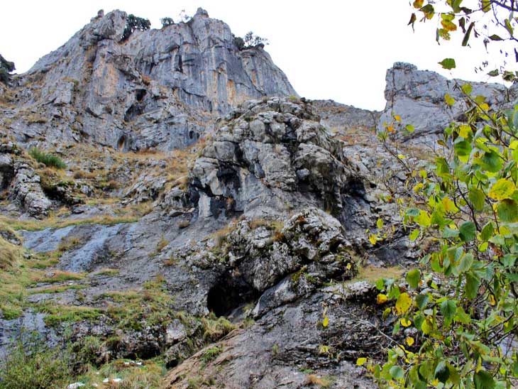
Gorges of Villar-CC/Marta Arias
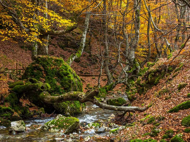
Faedo of Ciñera-CC/Guillén Pérez

Many people turn back here, but we decide to continue across the bridge and enter the Gorges of Villar. This part of the route is rougher and requires us to climb some steps carved into the rock and then cross a somewhat aerial area equipped with a chain that makes the task easier. This section is not very complicated but it does require a certain amount of caution. After crossing it, a footbridge hanging from the rock face awaits us, allowing us to walk through the narrow gorge created by the stream. Again the experience does not last long and the Gorges of Villar (0h 50min) come to an end, although they leave us some nice waterfalls beforehand. Not to be forgotten are the Marmitas del Gigante, pools carved by the waters of the stream that make this spot even more beautiful. From here we can ascend the mountainside following the path that will take us to Villar del Puerto. From there we can return along the road that joins it with Ciñera, thus making a circular route of just over 11 km, or we can follow the same path. However, the stretch of ascent that separates us from the plateau where Villar del Puerto is located is quite steep and demanding, increasing the difficulty of the route.
1-As in any beech forest we visit, autumn is the most spectacular time to visit this interesting route, although the rest of the year does not lose its charm.
2-Be careful in the Gorges of Villar in winter, an avalanche already cost the lives of several miners a few years ago.
3-As long as we do not extend the route to Villar del Puerto, this is an ideal route to enjoy with the family.
4-It is always important to be respectful of the natural environment we visit and on this occasion it is even more important to stay within the designated route and to respect the flora and fauna of the area given its delicate balance.
 |
 |
 |
 |
 |
| 1-Ciñera | 0:00h | 1060m | 0Km | 30T 284714 4751300 |
| 2-Faedo of Ciñera | 0:35h | 1125m | 2,3Km | 30T 286737 4751402 |
| 3-Gorges of Villar | 0:50h | 1180m | 2,7Km | 30T 287006 4751554 |
Coordinates UTM Datúm WGS84

.png) Distance: 5,4Km
Distance: 5,4Km
.png) Time: 1:40h
Time: 1:40h
.png) Difficulty: Low
Difficulty: Low
 Slope: 340m
 Slope +170m
 Slope -170m
 Maximum altitude: 1180m
 Minimum altitude: 1060m

![]()
This schematic with the path is approximate and has been created from the derived cartographic base © Instituto Geográfico Nacional "Cuadrante 103-4 1:25.000".

The church of the 365 corners, as many as the days of the year

Sistine Chapel of Romanesque Art, palatine temple of the kings Fernando I and doña Sancha

¿Did you know that...
El Faedo of Ciñera was declared the Best Kept Forest in Spain in 2007. This recognition was awarded by the Ministry of the Environment and the NGO Bosques sin fronteras.
Don't miss out...
The Derrick of the Ibarra Shaft in the upper part of the Ciñera mine will give you a better idea of the mining work carried out until not so long ago in this valley in the north of the province of León.


From the commitment of SENDITUR with Nature and the respect to the balance of the environment, SENDITUR urges you to travel in a responsible way, with low environmental impact and respecting at all times the Natural, Cultural and Social environment wherever you go.

Besides sharing with all of us your experience on the route we would be grateful if you could write to us to inform us of any erroneous or outdated information you may have found, or simply to let us know what you think at Thank you.
Route information updated on 05-06-2021. The route may vary greatly depending on the time of year, weather conditions and terrain, as well as the actions of third parties and the evolution suffered in the natural environment where it is located. All opinions, advice and/or assessments made by SENDITUR in their descriptions are for guidance only and are subject to and/or refer to the specific conditions of the specific day of the route, referring to that specific day, taken from trained people, with the appropriate experience and with a high level of physical and technical preparation as a reference, as well as correctly equipped.
All the times are approximate and take an orientative character, the stops have not been taken into account, no matter how small they are. All the information related to the route, texts, images, videos, maps, diagrams, tracks, towns, and places of tourist interest are published as a guide, and may not coincide with the current state of each place. Before undertaking any activity, assess your technical knowledge, your physical condition, find out about the weather and the variations that the route may undergo, equip yourself correctly, be prudent and responsible at all times, and do not exceed your capabilities. SENDITUR is not responsible for any misuse or inappropriate use of the comprehensive guides of its routes and/or publications as well as its electronic guides, nor for any variations in their descriptions for the aforementioned reasons, and recommends that everyone be responsible and prudent in carrying out the activity. We also encourage you to read books and specialised guides to complement the information described above.
Continue watching …


