Welcome to SENDITUR.COM · paths · routes · tourism

![]() Difficulty-Low
Difficulty-Low
![]() 0:35 h.
0:35 h.
![]() 1.8 km.
1.8 km.
![]() Difficulty-Low
Difficulty-Low
![]() 0:35 h.
0:35 h.
![]() 1.8 km.
1.8 km.
The mountains surrounding the Riojan town of Anguiano hide beautiful, almost magical places. Caves with curious legends, crags that even tell us what time it is at a certain moment of the day or spectacular spots with breathtaking views such as those that await us at the The Windows viewpoint. A balcony from which we can look out over the valley where the town is located, while we are carefully observed by the vultures that guard these crags.
In the middle of the Regatillo track, where routes such as the Serradero or Peñas run, we find the start of this interesting route. Specifically, the start awaits us shortly before reaching the Eras de Anguiano neighbourhood, in the spot known as La Acebaleda (0h 00min). One of the signposts of the Routes between beech forests marks the exact spot where we must leave the track. Right there begins a narrow path that ascends the mountainside, almost parallel to the track we have left behind.

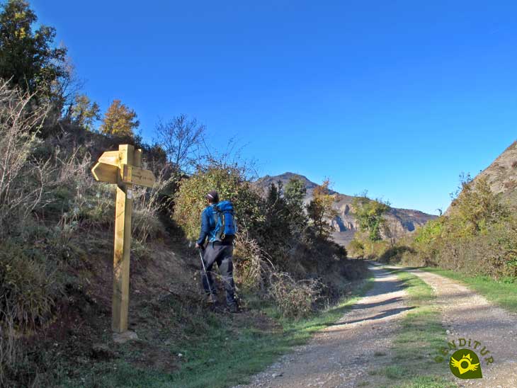
Start of the route to the viewpoint The Windows

Arriving at The Windows

One of The Windows

Panoramic view of Anguiano

The Windows and Planos Rock
Our path crosses the mountainside between pastures and small boxwood forests, while the Regatillo track gets lower and lower.
After a while, on our left we can already see the crags we are heading towards. Our path takes us easily to the edge of these colossal crags, where we can already see the hollows known as The Windows (0h 25min). Once at the top of the crags we can enjoy beautiful views that we can enlarge if we go up to the apex of the mountain on which the crags we are visiting are located. Once you have enjoyed this spot, all you have to do is return to the starting point along the same route you ascended.
1-Even if you are not doing any of the routes that pass through the starting point of this path, you can take a walk from Anguiano to get to know this viewpoint, the total route would be just over 6 km.
2-SIf, on the other hand, you are coming doing one of these routes, you should not miss the opportunity to go to the viewpoint, although it is important to assess your level of tiredness, as it is just another effort.
3-The route by itself is not very physically demanding, the slope is easy to overcome and the distance, even including the return journey, is not at all remarkable..
4-Even if you only come exclusively to visit the viewpoint, make sure you equip yourself properly, as it is still a mountain trail.
 |
 |
 |
 |
 |
| 1-Acebaleda | 0:00h | 750m | 0km | 30T 520953 4679096 |
| 2-The Windows | 0:25h | 845m | 0.9Km | 30T 520150 4678992 |
Coordinates UTM Datúm WGS84

.png) Distance: 1.8Km
Distance: 1.8Km
.png) Time: 0:35h
Time: 0:35h
.png) Difficulty: Low
Difficulty: Low
 Slope: 220m
 Slope +: 110m
 Slope -: 110m
 Maximum altitude: 845m
 Minimum altitude: 750m

This sketch of the route is not made to scale nor does it contain all the information relating to the area, it is merely indicative.

![]()
This schematic with the path is approximate and has been created from the derived cartographic base © Instituto Geográfico Nacional "Cuadrante 241-1 1:25.000".

Location of the Virgin of Valvanera, Patron Saint of La Rioja

¿Did you know that...
Anguiano is famous, among other things, for its beans. The climate and the altitude at which they are grown make them different from the rest of the beans grown in La Rioja, giving them unique characteristics that are highly appreciated by chefs and diners.
Don't miss out...
The different hiking walks that are organised in the mountains of Anguiano throughout the year. Some of these walks have been taking place for more than 15 years, bringing together hikers from all over Spain.


.jpg)

From the commitment of SENDITUR with Nature and the respect to the balance of the environment, SENDITUR urges you to travel in a responsible way, with low environmental impact and respecting at all times the Natural, Cultural and Social environment wherever you go.

Besides sharing with all of us your experience on the route we would be grateful if you could write to us to inform us of any erroneous or outdated information you may have found, or simply to let us know what you think at Thank you.
This route has been carried out in the field by SENDITUR on 25-11-2021. The route may vary greatly depending on the time of year, weather conditions and terrain, as well as the actions of third parties and the evolution suffered in the natural environment where it is located. All opinions, advice and/or assessments made by SENDITUR in their descriptions are for guidance only and are subject to and/or refer to the specific conditions of the specific day of the route, referring to that specific day, taken from trained people, with the appropriate experience and with a high level of physical and technical preparation as a reference, as well as correctly equipped.
All the times are approximate and take an orientative character, the stops have not been taken into account, no matter how small they are. All the information related to the route, texts, images, videos, maps, diagrams, tracks, towns, and places of tourist interest are published as a guide, and may not coincide with the current state of each place. Before undertaking any activity, assess your technical knowledge, your physical condition, find out about the weather and the variations that the route may undergo, equip yourself correctly, be prudent and responsible at all times, and do not exceed your capabilities. SENDITUR is not responsible for any misuse or inappropriate use of the comprehensive guides of its routes and/or publications as well as its electronic guides, nor for any variations in their descriptions for the aforementioned reasons, and recommends that everyone be responsible and prudent in carrying out the activity. We also encourage you to read books and specialised guides to complement the information described above.
Continue watching …


