Welcome to SENDITUR.COM · paths · routes · tourism

![]() Difficulty-Low
Difficulty-Low
![]() 0:45 h.
0:45 h.
![]() 2 km.
2 km.
![]() Difficulty-Low
Difficulty-Low
![]() 0:45 h.
0:45 h.
![]() 2 km.
2 km.
Anguiano is the gateway to the upper part of the Najerilla valley and at the same time one of the main access points to the La Demanda mountain range. The vertical crags under which this Riojan village sits are a meeting point for climbers, home to birds of prey, and unbeatable balconies from which to look out over the landscape. One of these balconies is the Viewpoint Portillo Rock, which can be reached via an entertaining hiking route that crosses the abrupt slope of the mountain surrounded by holm oaks.
The hermitage of La Magdalena (0h 00min) is the starting point of two of the routes through beech forests, the Route of Rocks and the Route of Roñas. It is also the starting point of the route that takes us to the viewpoint of Portillo Rock. Specifically, the start of the route is to be found at the back of the hermitage. Follow the itinerary of the Route of Rocks bordering the hermitage for a few metres, leaving aside that of the Route of Roñas. Just before leaving the hermitage behind, we will find the path we should follow.


Start of the route to the Peña Portillo Viewpoint
Trail of the route

Views of Anguiano

Views of the Najerilla River

Hermitage of La Magdalena

Trail of the route
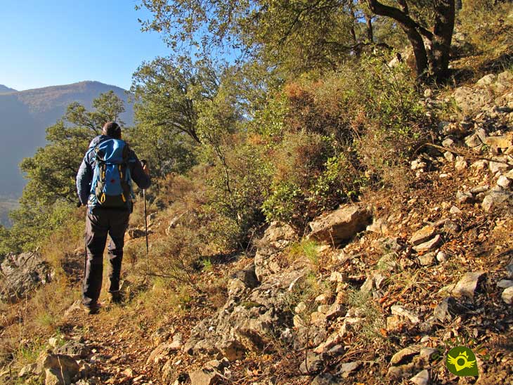
The path is almost covered by vegetation and climbs gently in the direction of Anguiano.
After a short while, just after passing near some beehives, our path turns into a narrow trail that enters the holm oak forest. This path runs halfway up the slope surrounded by holm oaks. The steepness of the terrain makes the route even more entertaining. The route is not very steep, it goes up and down continuously and takes us to a clearing where the viewpoint Portillo Rock (0h 30min) awaits us . We will have to walk around the area to be able to enjoy the different panoramic views it offers. For example, a cut between the crags allows us to jump to the other side of the vertical wall that has accompanied us this far, to enjoy the views from that side. Once we have had our fill of these landscapes, we return to the hermitage of La Magdalena following the same route that brought us here.
1-The route does not present any major complications, although due to the type of terrain over which it runs, you will have to pay attention in some sections.
2-There are some quite vertical areas, especially around the viewpoint, so be careful.
3-Visiting this viewpoint is well worth it, even if you are not doing any of the routes that link the route, from Anguiano you have just over 5 km in total.
4-You will encounter the occasional trail that descends down the hillside, the route is practically at the same altitude all the way, and the path markings will serve as a reference in case you have any doubts.
 |
 |
 |
 |
 |
| 1-La Magdalena Hermitage | 0:00h | 800m | 0km | 30T 520121 4677684 |
| 2-Portillo Rock | 0:30h | 820m | 1Km | 30T 519425 4678378 |
Coordinates UTM Datúm WGS84

.png) Distance: 2Km
Distance: 2Km
.png) Time: 0:45h
Time: 0:45h
.png) Difficulty: Low
Difficulty: Low
 Slope: 130m
 Slope +: 65m
 Slope -: 65m
 Maximum altitude: 820m
 Minimum altitude: 800m

This sketch of the route is not made to scale nor does it contain all the information relating to the area, it is merely indicative.

![]()
This schematic with the path is approximate and has been created from the derived cartographic base © Instituto Geográfico Nacional "Cuadrante 241-1 y 241-3 1:25.000".

Location of the Virgin of Valvanera, Patron Saint of La Rioja

¿Did you know that...
In the mountain crags of Anguiano there has been a climbing school since 2003, it has different routes of medium and even higher grade, there are different guides with all the necessary details.
Don't miss out...
The typical and traditional dish that characterises Anguiano, beans. Throughout the year, different themed days are held with beans as the main ingredient.


.jpg)

From the commitment of SENDITUR with Nature and the respect to the balance of the environment, SENDITUR urges you to travel in a responsible way, with low environmental impact and respecting at all times the Natural, Cultural and Social environment wherever you go.

Besides sharing with all of us your experience on the route we would be grateful if you could write to us to inform us of any erroneous or outdated information you may have found, or simply to let us know what you think at Thank you.
This route has been carried out in the field by SENDITUR on 25-11-2021. The route may vary greatly depending on the time of year, weather conditions and terrain, as well as the actions of third parties and the evolution suffered in the natural environment where it is located. All opinions, advice and/or assessments made by SENDITUR in their descriptions are for guidance only and are subject to and/or refer to the specific conditions of the specific day of the route, referring to that specific day, taken from trained people, with the appropriate experience and with a high level of physical and technical preparation as a reference, as well as correctly equipped.
All the times are approximate and take an orientative character, the stops have not been taken into account, no matter how small they are. All the information related to the route, texts, images, videos, maps, diagrams, tracks, towns, and places of tourist interest are published as a guide, and may not coincide with the current state of each place. Before undertaking any activity, assess your technical knowledge, your physical condition, find out about the weather and the variations that the route may undergo, equip yourself correctly, be prudent and responsible at all times, and do not exceed your capabilities. SENDITUR is not responsible for any misuse or inappropriate use of the comprehensive guides of its routes and/or publications as well as its electronic guides, nor for any variations in their descriptions for the aforementioned reasons, and recommends that everyone be responsible and prudent in carrying out the activity. We also encourage you to read books and specialised guides to complement the information described above.
Continue watching …


