Welcome to SENDITUR.COM · paths · routes · tourism

Route of the Serradero
Administrative Boundary Ancestral Twinning of Peoples and People
![]() Difficulty-Moderate
Difficulty-Moderate
![]() 5:25 h.
5:25 h.
![]() 16.9 km.
16.9 km.
Administrative Boundary Ancestral Twinning of Peoples and People
![]() Difficulty-Moderate
Difficulty-Moderate
![]() 5:25 h.
5:25 h.
![]() 16.9 km.
16.9 km.
![]()
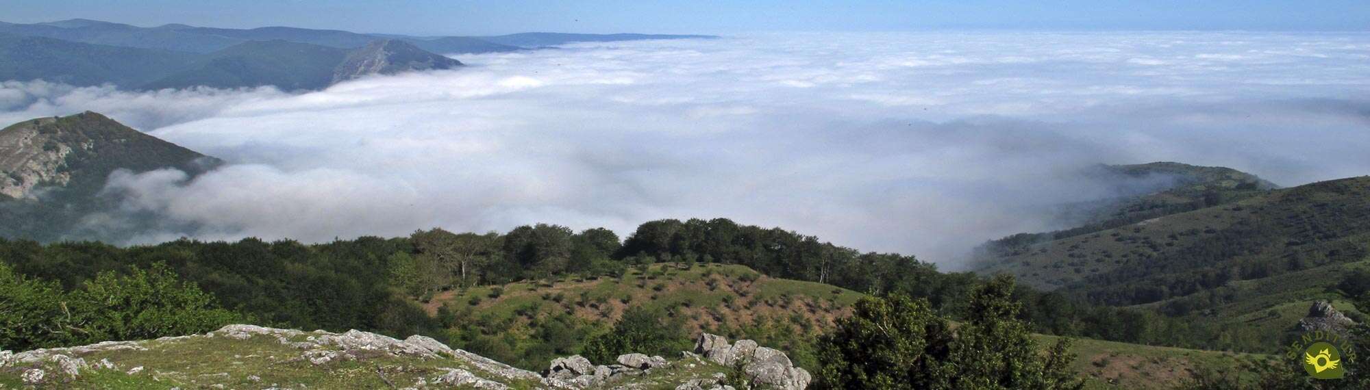
La Rioja, despite its size, has a remarkable number of valleys that, from the high peaks of the southern mountains of the community, descend quietly to meet the wide valley of the Ebro. Valleys such as the Najerilla, where Anguiano is located, separated from its neighbouring Iregua valley by rounded mountains whose slopes are home to dense beech, pine or oak forests, green meadows and deep ravines whose streams nourish the river that runs through the valley.

The Route of the Serradero, with its 15.8 km, one of the countless hiking routes available in this area of La Rioja, takes us in search of the natural border that separates these two valleys of La Rioja. A circular route that starts from Anguiano, begins a hard ascent that compensates those who undertake it with the unbeatable views of the different neighborhoods that make up the town. We gained height under the attentive look of the imposing rocks under which Anguiano lies, rocks on which the unmistakable silhouettes of the birds that dwell in them glide. Soon we will see ourselves walking through the thickness of the forests that grow in these mountains, advancing hand in hand with other routes with which we coincide in our itinerary, trails of La Rioja as the GR 93 that here joins Anguiano with Nieva de Cameros, and other more local as the Route of Roñas or the Route of Rocks that joins us for a moment before reaching the Pass of La Tejera, where he will leave us. It is a hard ascent that we must face but that is partly mitigated by the places it crosses, places such as the Aidillo beech forest or the abrupt Congostos, where we will say goodbye to another of our companions the Route of Roñas. With the only company of the GR 93, we will continue up the mountain before going back into the forest to look at the Regatillo ravine, on whose exclusive rocky hillsides sits the millenary Yew tree. The Pass of La Mohosa awaits us after a short and undulating journey, crossing the streams that flow down the hillside.

Here, after jumping the imaginary border that separates the Najerilla valley from the Iregua valley, it is time to say goodbye to the GR 93 that continues its course towards Nieva de Cameros. A long stretch awaits us patrolling this division of municipalities while we continue to gain altitude without so much demand. Once again in the lands of Anguiano, we will move away for a moment from the wire fence that separates both towns to border the Morro Gimeno and thus enjoy the valley from which we started. A quiet journey, crossing green meadows, which brings us to the detour that leads to the Crooked Beech or the N and where we also have the opportunity to crown the Muélago Peak. Once visited these places, in this same place begins the long descent that in a first term will lead us to Fuente Bajera from where once again we will have to recover part of the lost height, to later descend without more delays towards the valley. A descent through a beech forest first and then through the unpopulated shoulder of the mountain, to enter another beech forest and continue descending. The Peñas Route awaits us and together we will follow the perfect track that descends to Anguiano itself, where we will once again say goodbye to our friend and enter the town. We will walk through the streets of this town, going up the course of the Najerilla and crossing such emblematic places as the Plaza Mayor, Anguiano, to close the circle of this hiking route a few metres further on and bring our unforgettable adventure to an end.

One of the great advantages of the Anguiano Mountains, in addition to their great scenic value, is the great variety of different routes that we can follow and that are intertwined with each other, allowing us to adapt or create a route that suits our tastes or capacities and always following well-marked itineraries that allow us to approach the beautiful corners of this town in La Rioja.
The municipality of Anguiano is reached by following the LR-113 that links Nájera with the Burgos town of Salas de los Infantes. This same road, in Nájera, connects with the A-12, Autovía del Camino and with the N-120, between Burgos and Logroño. There is also an extensive schedule of intercity buses that connect Anguiano with both Nájera and Logroño. Once there, on the road that crosses the town, at the exit of Anguiano towards Monasterio de Valvanera, we will find a parking area where we can leave our vehicle.
Without a doubt our dog must be used to this type of route before we take him on this trekking route. His mileage and his slope will test our friend's endurance. Pay attention to the wire fence that separates the two municipalities.
We will find many water points along the route but depending on the time of year when we develop the activity with our dog, we are not guaranteed to find all of them with water. It is also important that we bring him food to replenish his energy on the route.
The cattle, the dogs that accompany him and those that we have to meet in our urban route, do not make advisable that we leave our companion that is much to his air, in addition to the different tracks that along the route can get to find and that can make him lose track of us if we are not attentive to him.
The first steps of this trekking route in La Rioja, make us walk a short stretch of the streets of Anguiano (0h 00min), starting from the parking that is located at the foot of the vertical cliffs under which sits this town.

Leaving behind the road by which we reached Anguiano, we began the long ascent that awaits us ahead, leaving, almost at the moment of beginning, on our left the street by which we will return at the end of this tour, to climb the stairs that mark the beginning of the path.

The trail begins to ascend, following the fence that delimits it, which forces us to cross it a little further on.

After passing through the gate that prevents animals from passing through, we will continue ascending outside the limits of the village.

The trail, somewhat bare and with a remarkable slope, makes us gain height not without effort. A new gate stands in our way, forcing us to cross it in order to continue with our route.

A little further on, our trail turns slightly, just enough to start to move away from Anguiano for good. We advanced by cutting the slope of the mountain and gaining height every moment as we forced ourselves to stop to behold the landscape and thus recover our breath.

To our left is the ravine we are climbing up. The path, usually well trodden, brings us little by little closer to the thick forest that we will have to walk.

After a while, the vegetation takes over the landscape until, almost without realizing it, it hides it from our sight. Now we will see ourselves walking through the forest under the protection of the trees that surround us.

The leaf litter barely gives an idea of the narrow trail we are following, although in general there should not be too many doubts about the route to be followed.

Only in rare cases will we be forced to stop for a moment to locate, thanks to the route markings, where the trail continues.

Later on, our little doubts are dispelled while our trail becomes a kind of path that runs through the forest.

Almost at the end of this part of the ascent we will be joined on the right by another of the Routes between Beech Forests, the Route of Rocks.

Together we will go through the final part of the forest at whose edge the Pass of La Tejera awaits us (1h 20min), where we will say goodbye to the company of the Route of Rocks.

While our old companion begins her descent towards Anguiano following the wide track that passes by here, we, through this same track but in opposite direction, will continue the ascent next to the GR 93 and the Route of Roñas which will still accompany us a good stretch.

Once again, the thick beech forest envelops us with its freshness, while we almost never stop gaining height.

The forest gives way to the vertical rocks that shape the characteristic landscape of Congostos. Here we will have to face some of the most demanding ramps of this route, already without the protection of the trees and their shade.

After these ramps and surrounded by the magnificent landscape of Congostos (1h 50min) we will find the crossroads that we must follow leaving behind the track and the Route of Roñas that continues through it.
The slope continues without leaving us a moment's respite, forcing us to take this part of the route calmly.

The marked path blurs under the green grass making us pay attention to the marks on the path. Almost at the end of the ascent, our path abandons us completely, leaving us at the mercy of the posts that mark the route.

Luckily, between them and the small trail that begins to be seen, we climb without major complications this winding stretch that raises us to a wide pass from which we will have impressive views.

After recovering our breath and without stopping gaining height we will go back into the vegetation.

Our itinerary changes course again as soon as we are surrounded by the thick vegetation. This part of the route runs again on a marked trail and together with the signs of the GR 93 and our route, will lead us without major problems to our next objective.

Our path cuts the side of the mountain, drawing its outline on the changing profile of the mountain. The forest gives us a few breaths in the form of a small clearing that quickly gives way to the greenery that surrounds this stretch.

A continuous up and down characterizes this part of the route in which fortunately the slope, except in small moments, is no longer as marked as on previous occasions.

The leaf litter that covers the ground, together with what seems to be other trails that also run through this mountain, may confuse us if we do not pay attention to the marks of the path.

The mud, especially that caused by the different streams that run down the slope, can also test us on several occasions. Streams that force us to lose height in order to cross them and then go back up the lost slope.

There will not be many crossroads or trails that we will encounter and in all of them the marks will be of great help to take the correct route.

Depending on the time of the year, some of the streams may run quite low, making it more difficult to wade.

Once again a new ramp will test our strength, but it will also warn us of the proximity of the pass we are heading for.

A ramp whose slope gives us a break shortly before entering the forest once again after leaving behind another of the clearings we will pass through. A forest that gives us a pleasant walk without the demands of past sections.

Forest that leaves us at the gates of the Pass of La Mohosa (2h 35min) and the gate that separates the municipalities that coincide here.

As soon as we pass this gate we will say goodbye to our hitherto inseparable companion, the GR 93, which continues its course towards Nieva de Cameros, to turn radically to our left and continue along the fence that acts as a boundary between the two municipalities.

If we thought that the ascent was over, nothing could be further from the truth, we still have height to gain. The path we are following borders on the fence for the time being.

The slope reminds us again that we have not yet reached the top of this trekking route in La Rioja.

Our marked path leads us directly to another new gate, which we will cross to enter again the lands of Anguiano.

With the fence now on our right and further away from us, we follow the course that marks the border between these two towns in La Rioja. The path, although present, is once again covered by the colourful cape that covers this area of the mountain.

The landscape around us makes this part of the tour much more entertaining. We have to pay attention to the marks on the route as it leaves the company of the border fence for a while.

The route leads us to the rocky wall that separates us from the Najerilla valley. A wall that we will save while following the greenish path that guides us.

A path that should not be left at any time, unless we want to come and contemplate the panoramic view that this place offers.

As usual, once again we have to go up the hills that cross our route to quickly undertake a short descent in search of the next one.

This wide area of pastures makes us pay attention to the posts and signs on the route as the path appears and disappears as you like.

These will prevent us from having to climb another hill, by making us turn to our left to cut its hillside.

Again it is the poles that will indicate the beginning of the path that will guide us in the future.

A path that seems to lead us to the craggy mountain on our left that we have been observing for some time now.

This is a mountain that, except for some parentheses in our route, we will not tread on since when we reach its shoulder a sudden change of course awaits us and the possible detour towards the Crooked Beech (3h 20min).
It is at this point that we will begin the long descent that will take us back to Anguiano, always of course we do not decide to approach this unique tree of La Rioja.

In any case it is here that we will return, leaving now to our right the rocky peak that we have observed so much and the path that leads to it.

The descent, after overcoming a first wooded area, takes us right into a wide ravine. We lose height with every step as we cross the green fields of grass.

The woods are once again taking centre stage, not least on hot days. But this one hardly accompanies us for a few meters leaving us again at the mercy of the implacable sun.

Ahead of us a steep path continues with the long descent that lies ahead. In the distance we can contemplate the landscape that awaits us, without being aware of the short but demanding ramp that we will have to save.

Our route changes from the hillside of the ravine, to get us out of it on the left side. The marks lead us to a lonely post at the base of the steep shoulder that we seem to have to climb up.

Our fears are confirmed when we reach the height of the post of the Route of the Serradero, which tells us that we will have to make another effort.

This section, although short, is demanding, but fortunately shortly before reaching the end we will have to turn off to continue the descent. A steep descent through the interior of a beech forest following a wide path that soon turns into a narrow path that takes us out of the beech forest.

This beech forest will serve as a reference point, as our route continues to descend without straying too far from its limits. A little further down, to our left, we can already see a solitary tree next to some crags, the tree we are heading towards.

When we reach it, the route makes us change direction radically, to cut through the mountainside in search of the place where we will cross the ravine that cuts off our path.

Without practically losing height the path takes us to the interior of another beech forest where we cross the ravine and begin to descend it, at least for a few metres. We quickly come across the path that we must follow, a path that cuts through the side of the ravine, which is lower and lower.

This path seems to take us out of the beech forest, but almost immediately we enter it again to resume the descent that we had postponed. This part of the route goes through the beech forest following what seems to be an old path covered by leaves.

Luckily we have the invaluable help of the route markers that make our work easier. After a good while descending and shortly after crossing a stream, our path comes out onto the track that will take us to Anguiano.

Here we have the option of ascending to La Tejera to return along the initial section of this route, or continuing the descent along the track with the company of the Rock Route. If this is our option, all we have to do is follow the route of the track without deviating from it at any time.
Once together, a few kilometres of track await us, descending the nearby stream we have just crossed, without having to take any more detours until we reach Anguiano itself.

After a while, however, we will come across the post that indicates the most advisable detour that takes us to the beautiful Viewpoint of the Windows

We leave this turn-off behind us and continue to lose height, ignoring all the paths we come across, while the route allows us to contemplate in detail some of the steep crags that surround the town.

The first buildings in the town welcome us on our arrival, marking the moment to say goodbye again to the Route of Rocks that continues its course while we enter Anguiano.

The urban layout of our route will take us through the town from side to side. On our way we will leave behind all the streets that come out to meet us.

The street through which we entered Anguiano definitely takes us out of one of the three neighborhoods in the town.

On our right we can see the road that leads to the parking lot from which we started, but we will continue to walk the streets of the municipality.

Streets of notable slope that for now we will not have to face since our route follows another itinerary. A route that takes us parallel to the nearby road towards which we are inevitably heading.

Our journey without us realizing it brings us closer to the heart of Anguiano with every passing moment. Before us is the Plaza Mayor, which we will cross from one side to the other, to continue with the route.

Now all that remains is a quiet descent with no more detours towards the near end of the route. The parking area where we start from Anguiano is waiting for us at the end of the street we are walking on. The end of this street coincides with the end of this trekking route through the mountains of Anguiano (5h 10min).
 Distance. 16.9Km
The different options offered by the route allow us to adjust the distance to our liking.
 Time. 5:25h
Unless we decide to approach some of the singular trees that can be reached by taking the appropriate detours on the route, we would not have to add much more time to the already mentioned.
 Time of year
Spring and autumn are the periods of maximum splendour of the landscape that surrounds this route. The forests, mountains and fields through which it passes, undoubtedly have a great environmental, landscape and natural value throughout the year, but the weather conditions, of course, must be taken into account in routes of these characteristics.
 Required equipment
Including the information of the route and the necessary material to be able to follow its course in case of necessity is never a bad election and less in routes of this importance. Feeding and hydrating ourselves correctly will help us not to suffer unnecessarily on demanding routes like this one. The walking sticks will undoubtedly be good companions and suitable footwear will help us in the most mountainous areas of the route. The difference in altitude between Anguiano and the highest area of the route must also be taken into account when deciding on the clothes to wear. Consult our list of material and equipment for hiking. Read more.
 Difficulty. Moderated
Physical
It is a demanding route due to the distance and the accumulated unevenness that has to be overcome, so it is only advisable for people with certain capacity and preparation. Ramps of notable slope, long and demanding descents, join the almost 16 km total that can be even more to take the proposed detours along the route. That is why it is important to take the first part calmly as we will be in the middle of the ascent as soon as we start.
Severity of the environment
If we don't go off the beaten track and under normal conditions we shouldn't encounter too many complications. The mud in some areas, the flow of the streams to be crossed and the steepness of the descent are the usual problems we will have to face. We must not forget that some stretches run through areas without apparent danger, but that their limits in some cases have vertical cuts that it is better not to get close to.
Orientation
Signposted at all times, it is the different paths or routes with which we will coincide at some point that, if we are not clear about our itinerary, can put us in doubt. We will pass through pastures where, as in the woods, we will have to pay attention to the marks of the route since the trails and paths that cross them are usually not as well trodden or clear as in other parts of the route. On days with poor visibility, it is relatively easy to get lost if you do not have the necessary experience and equipment.
 |
 |
 |
 |
 |
| 1-Anguiano | 0:00h | 644m | 0Km | 30T 519240 4678550 |
| 2-Pass of La Tejera | 1:20h | 1004m | 2.5Km | 30T 521441 4678002 |
| 3-Congostos | 1:50h | 1156m | 3.7Km | 30T 521596 4677013 |
| 4-Pass of La Mohosa | 2:35h | 1294m | 5.7Km | 30T 522804 4675880 |
| 5-Detour Crooked Beech | 3:20h | 1427m | 8.6Km | 30T 524562 4677203 |
| 6-Link Route of Rocks | 4:10h | 940m | 12.2Km | 30T 521963 4677600 |
| 7-Anguiano | 5:25h | 644m | 15.8Km | 30T 519240 4678550 |
Coordinates UTM Datum WGS84

 Slope: 1840m
 Slope +: 920m
 Slope -: 920m
 Maximum altitude: 1427m
 Minimum altitude: 644m

This sketch of the route is not made to scale nor does it contain all the information relating to the area, it is merely indicative.

![]()
This schematic with the path is approximate and has been created from the derived cartographic base © Instituto Geográfico Nacional "Cuadrante 240-2, 240-4, 241-1 y 241-3, 1:25.000"
Senditur has manipulated the tracks to correct the aberrant points that may exist, caused by problems with the reception of the GPS signal. In any case the tracks are always approximate. SENDITUR encourages you to use the new technologies within your reach, using them as support and consultation in your activity, not basing the realization and orientation of the same only and exclusively on them, since they may see their functioning altered by very diverse causes, not functioning correctly and their indications may not be precise.


Bonita ruta que nos sube hasta el Serradero pasando por la Mohosa (que tiene encanto); con un descenso un poco empinado pero precioso por las vistas...

Location of the Virgin of Valvanera, Patron Saint of La Rioja


Cradle of the Castilian and pantheon of the seven Castilian heroes

¿Did you know that...
The highest part of this Route of the Serrado goes not only between the limits of the municipal terms of Anguiano and Nieva de Cameros, it is also the natural separation of two slopes, the one of the valley of the Najerilla to our left and the one of the valley of the Iregua to our right, always according to the direction of the march of course. This natural border also acts as a watershed, turning its streams towards one or another valley depending on the hillside where they run.
Don't miss out...
The views that we can contemplate if we leave the path for a moment and approach its apex on the Morro Gimeno. You will find this small detour without signs in the stretch of road that separates the fence that delimits Anguiano and Nieva de Cameros. When the path changes course again to skirt it and begins to ascend, on our left behind some stones a meadow opens up on whose rocky apex a magnificent balcony overlooking the Najerilla valley awaits us.


.jpg)

From the commitment of SENDITUR with Nature and the respect to the balance of the environment, SENDITUR urges you to travel in a responsible way, with low environmental impact and respecting at all times the Natural, Cultural and Social environment wherever you go.

Besides sharing with all of us your experience on the route we would be grateful if you could write to us to inform us of any erroneous or outdated information you may have found, or simply to let us know what you think at Thank you.
This route has been carried out in the field by SENDITUR on 24-06-2017. The route may vary greatly depending on the time of year, weather conditions and terrain, as well as the actions of third parties and the evolution suffered in the natural environment where it is located. All opinions, advice and/or assessments made by SENDITUR in their descriptions are for guidance only and are subject to and/or refer to the specific conditions of the specific day of the route, referring to that specific day, taken from trained people, with the appropriate experience and with a high level of physical and technical preparation as a reference, as well as correctly equipped.
All the times are approximate and take an orientative character, the stops have not been taken into account, no matter how small they are. All the information related to the route, texts, images, videos, maps, diagrams, tracks, towns, and places of tourist interest are published as a guide, and may not coincide with the current state of each place. Before undertaking any activity, assess your technical knowledge, your physical condition, find out about the weather and the variations that the route may undergo, equip yourself correctly, be prudent and responsible at all times, and do not exceed your capabilities. SENDITUR is not responsible for any misuse or inappropriate use of the comprehensive guides of its routes and/or publications as well as its electronic guides, nor for any variations in their descriptions for the aforementioned reasons, and recommends that everyone be responsible and prudent in carrying out the activity. We also encourage you to read books and specialised guides to complement the information described above.
Continue watching …


.jpg "Go to Estate of Ribavellosa")


