Welcome to SENDITUR.COM · paths · routes · tourism


GR 93 Section 3 Anguiano-Ortigosa de Cameros
From Najerilla Valley to Iregua Valley, we enter Los Cameros
![]() Difficulty-Moderate
Difficulty-Moderate
![]() 4:55 h.
4:55 h.
![]() 17.4 km.
17.4 km.
From Najerilla Valley to Iregua Valley, we enter Los Cameros
![]() Difficulty-Moderate
Difficulty-Moderate
![]() 4:55 h.
4:55 h.
![]() 17.4 km.
17.4 km.
It could be said that the GR 93 is the main footpath of La Rioja as it runs from west to east joining valleys, towns and regions while crossing the unique mountains that delimit the south of the community. Valleys such as the Najerilla Valley from where this hiking route departs to, following old paths, take us to the other side of the mountains, to the Iregua Valley in the region of Los Cameros Riojanos.

The GR 93 Section 3 Anguiano-Ortigosa de Cameros consists of 17.4 km through forests and mountains. The route makes us say goodbye to Anguiano and its three neighborhoods, border between the mountains and the Ebro valley, to climb the imposing mountains that surround it. Mountains that give us colorful beech forests, such as Aidillo, and vertical cliffs, such as those of Congostos, before crowning the roof of this route to our arrival at the La Mohosa Pass where we will take the leap of hillside at the same time we change municipality. A long effort the one of the ascent until this place that without hardly letting us recover the forces will put us of full in the sinuous path that descends in search of the stream of the Castejón, which will be the one in charge to lead us until the same doors of the locality of Nieva de Cameros, where its battered castle waits for us vigilant. The GR 93 will act as a tourist guide through the town as it continues its unstoppable course. The hermitage of La Soledad bids us farewell while we head towards the next town of Los Cameros through which we are going to pass.

The different landscape makes us seem to be in another route while we save the distance that separates us from El Rasillo de Cameros, with the view on the silhouette of the reservoir that is situated here. The church of Our Lady of the Eras welcomes us to the locality at the same time that we undertake the journey through its streets. A route that takes us to the same limits of El Rasillo de Cameros from where we will have to cross the final part of this route. A final part that crosses between forests of slender pines that enliven in part the steep ramps that we are finding in our journey. The abrupt ravine of Rioseco is what separates us from our objective, but before facing it we will be tempted by the spectacular subterranean world that houses the Ortigosa Caves, next to whose door we will pass. Already saved the vertiginous bridge that joins both shores of the vertical ravine awaits us the hermitage of Santa Lucia, entrance door of the GR 93 in Ortigosa de Cameros, and at the same time point and followed by its layout by La Rioja.

If you don't have enough time to follow the different stages of the GR 93 or if for any reason you just want to do this section and you don't have several vehicles to leave one at the beginning and one at the end of the route, you can take advantage of La Rioja's interurban transport service, since both Anguiano on the one hand, and Nieva de Cameros, El Rasillo de Cameros and Ortigosa de Cameros on the other, have bus lines that link them, daily and with different schedules, with Logroño capital, thus giving us the option of making this route without having to have several cars.
In the municipality of Anguiano we arrive following the LR-113 that joins Nájera with the town of Burgos, Salas de los Infantes. This same road, in Nájera, communicates with the A-12, Autovía del Camino and with the N-120 between Burgos and Logroño. There is also a wide schedule of intercity buses that connect Anguiano with both Nájera and Logroño. Once there, in the middle of the road that crosses the town, you will find, at the exit of Anguiano towards Monasterio de Valvanera, a parking area where you can leave your vehicle.
A route almost reserved for dogs that are accustomed to long and demanding journeys. Attention in the forested zones, it is relatively easy that ends up getting lost, also we will have to pass a short piece of road where it will be necessary to be extreme caution.
The water initially would not have to be a problem since in some zones we will transit near streams of easy access and even some we will have to wade them, in addition we will count on the sources of the towns where we will be able to fill the indispensable reserves that always we must take to him. It is also important to replenish energies along the route.
The cattle is one of the protagonists next to the dogs that take care of the flocks and with which it is probable that we meet, in addition we have to pass relatively near honeycombs of bees reason why it is important to be attentive to our dog.
We leave behind us the road that crosses Anguiano (0h 00min) and that makes the symbolic border between the section of the GR 93 of San Millán de la Cogolla and the one that arrives from Nieva, to go up the street that gives access to the center of the locality.

As soon as we do so, we come to some stairs that we must climb in search of the beginning of the path.

The trail begins to gain altitude as we approach a typical cattle fence, which we will cross.

We continue ascending, leaving the village of Anguiano behind us.

This part of the route climbs strongly up the slope of the mountain following the well marked path, sometimes somewhat decomposed.

Once again we will have to go through another gate for the cattle, while at our feet there are already the houses that give shape to this Riojan locality.

After a few meters, our path turns gently to the right to move away from the fence that accompanied us. We continue to gain height, not without effort, taking some moments of respite with the excuse of taking a look at the landscape that surrounds us.

After a while the vegetation begins to envelop us, providing us with its invaluable shade during the hottest months. The leaf litter that covers the ground begins to make us a little more difficult to follow the correct layout.

There will be several places where we will have to be attentive to the marks to avoid following wrong courses. But fortunately after a short time the trail becomes almost a wide path that clearly leaves its marked layout.

Almost at the end of this forest, on our right we are joined by another of the trails that cross these mountains. Together we will reach the La Tejera Pass, outside the forest.

Here, in addition to saying goodbye to the short companion who had just joined us, we will begin a relatively long stretch of track, though, while continuing to climb.

Once again, the forest will envelop us with its thickness, hiding the wild landscape that is beginning to surround us.

After a stretch of relative calm, as far as unevenness is concerned, we will again have to face hard ramps that ascend embedded between the gorges of Congostos. Behind us is this wild area of beautiful landscapes, while we face one of the most demanding areas of the entire route.

When it seems that the slope reaches its end, our route suddenly changes course again, abandoning the wide track and continuing with the ascent.

We are now faced with a green path that goes up the slope of the mountain towards the top of the hill in front of us.

Our path disappears leaving us at the mercy of the marks that mark the itinerary, if we pay attention we will also be able to see the apparent path that, winding, saves this hard slope.

The trail that once you reach the summit of the hill turns again to continue ascending towards the nearby forest.

Once there, a long stretch awaits us, which for the moment continues with the ascent. This part of the route, already a little less demanding, cuts the slope of the mountain following its sinuous profile.

There will not be many junctions that we will meet and luckily in all of them the signs of the GR solve any doubt.

The undulating route alternates areas of leafy forest with other clearer ones that allow us to contemplate the landscape that we are furrowing.

We will be forced to cross several streams that run downhill.

After a while our trail goes out to a new clearing here we will have to locate in front of us the GR marks that indicate the entrance of the route in another area of the forest. Zone that precedes our arrival to the point where we will finish this hard ascent from Anguiano.

The metallic door that separates the borders of Anguiano and Nieva de Cameros warns us of our arrival to the La Mohosa Pass.

Once overcome we will begin the descent that will take us until the following locality of La Rioja, by which we will pass. The forest is still our companion and the leaves are the carpet that almost hides the path we are following. We lose height relatively quickly as we advance attentive to the marks of the GR.

A new stream stands in our way, forcing us to ford it in order to follow the itinerary. The path sometimes looks more like a torrent through which the water flows on rainy days.

The leafy forest requires us to be careful not to miss any of the small turns that our path makes. Although as a general rule the path is clearly stepped on.

Almost at the end of the descent a new clearing comes out to our encounter, clear whose limit we will continue to take again, on the other side, the lost trail.

This part of the route is a succession of forested and clear stretches, in which the GR posts and marks are in charge of guiding us when the path we had been following disappears in them.

Once again the woodland claims its protagonism at the same time that it offers us its shadow.

But it quickly gives way again to a wide field of pastures in which the route turns radically to descend bordering the forest from which we have just left.

Almost at the moment and after a steep descent we will come across the track that will take us to Nieva de Cameros.

Road that for the moment we will not leave, no matter how many crossroads and roads we find. Already with a much more amiable profile we are advancing by this comfortable road, without for the moment we stop losing height.

There will be several junctions that we will be leaving behind us as we go down the course of the stream of Trampal until it joins the stream of Castejón which will accompany us from now on.

The farms and their corresponding buildings warn us of the proximity of the town towards which we are heading. The valley seems to be closing little by little as if it didn't want to let us out of it.

After a while we will arrive at a fork in our way, it is time to abandon it and start the ascent that will take us to Nieva de Cameros.

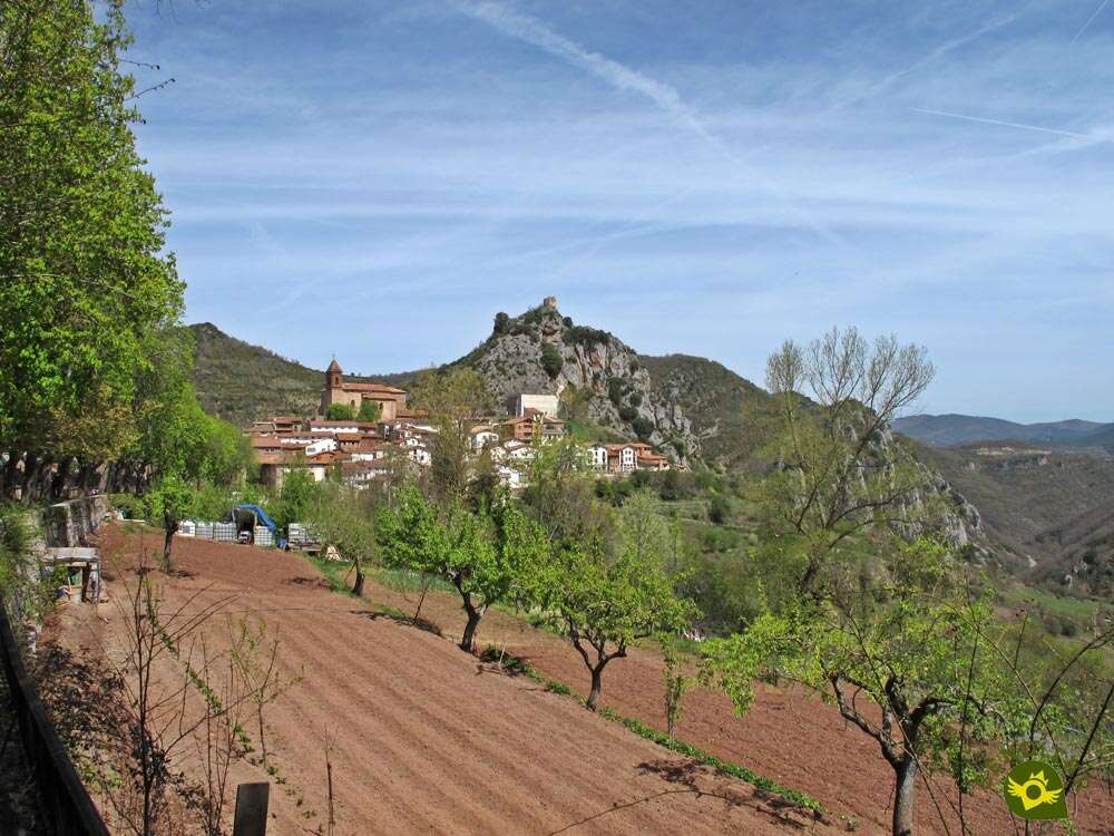
Ascent whose slope makes us a little harder than expected, accustomed to progress without further demands. The silhouette of the ruins of the castle of Nieva welcomes us from its privileged location.

The locality shows itself before us once this hard ramp is finished. The path takes us straight into the interior of the locality without making us doubt the route to follow.

The square of Nieva de Cameros (3h 10min) receives the GR 93, a square that we will cross heading towards its other end.
The GR 93 continues along the streets of Nieva de Cameros, descending in search of the road that gives access to the town.

We will leave this road on our left to start a new ascent following the street that borders a well cared park.

This landscaped zone will accompany us, now yes, up to the limits of Nieva de Cameros. Here, leaving behind the hermitage that marks out the landscaped zone, we will begin a new stretch of cobblestone path.

This part of the route turns into a fast and vertiginous descent that takes us directly to the reencounter with the road we left to one side.

Both the road and the path end at par when they meet the road that enters the valley in search of the next town to visit this GR 93. We will have to face a short but dangerous stretch on the asphalt.

Luckily before us quickly emerges the path by which we must continue, leaving the road.

After a few metres of road we will come across a new detour to our left, it is a short trail that cuts diagonally the distance that separates us from the new path we must follow, thus avoiding us to reach the crossing of this with which we now carry.

Practically at the moment of stepping on the new track we will leave it to follow the trail that crosses the base of the electric poles.

We are faced with a long stretch of well trodden path that gently climbs part of the previously lost height.

There will be several routes and trails that we have to find along this stretch. But the marks of the GR and the footprint of our itinerary should be sufficient references to follow.

After a while we will reach a wide meadow, which we will walk along its side. At the end of this green meadow we will have to ford a kind of muddy stream.

As soon as we do, we'll be cut off by a gate for the cattle we'll have to go through.

At this moment, on our right begins a battered and steep road that we must continue. After saving this hard steep slope, a more comfortable and less demanding area awaits us.

Again we find another crossroads, without having to change our course. Little by little the vegetation will envelop us as we get closer to our next objective.

Once fully immersed in the lush forest we can sense the proximity of the town that awaits us later.

Before we reach it, we'll have to go through a firewall that precedes it. Then our path comes to an end, leaving us at the beginning of the urbanization with which El Rasillo de Cameros receives us.
.jpg "At the second crossroads, continue on the right.")
Now we will have to cross the urbanization without for the moment change of course. But before we face the last section of the descent that leads to the nearby road that we traveled some time ago, we must detour and continue on the right.

This new street continues to cross the urbanization at the same time that it shows us the locality. A new road will cut us off at the end of our street, a road that we will have to cross to continue with our route.

This short stretch of road takes us directly to the asphalted track by which we will definitely enter El Rasillo de Cameros (4h 20min). That if not without first overcoming the unevenness and the distance that still separates us from the interior of the locality.
We bid farewell to the singular tree that has been growing for hundreds of years in the middle of El Rasillo de Cameros square, to continue our journey through the locality.

The typical marks of the GR 93 help us in our journey. Behind us there is also the fountain that marks out another of the squares of this village in La Rioja.

After a few meters following the road that gives access to El Rasillo de Cameros we will abandon it following the course of a new street.

Street that leads us quickly to another small square that marks our next march of this mountain town. After passing under the arcade of the house that closes this small square, we will begin to cross the short stretch that will finally take us out of the town.

The posters warn us of the distance that we still have to save, indicating to us at the same time the habitual thing of this route for the people who visit the zone.

This footpath to Ortigosa takes us out of El Rasillo de Cameros making us descend until the stream of San Mamed, whose normally dry channel we must cross to continue with our route.

The footpath takes us, with each step, away from the town we have just visited. There won't be many junctions or paths that we have to run into, but in any case the markings on ours will serve as a reference to follow.

A pleasant walk awaits us in front, sheltered by the lush vegetation that populates these mountains. The undulating terrain will force us to save the reefs that it is putting to our step.

After a gentle descent we will be forced, as could not be otherwise, to face a hard ramp.

Luckily, this effort will be protected by the freshness provided by the shade that surrounds the road we are traveling.

This path is cut off by the typical gate for cattle, which we will cross by its side. Already saved the unevenness and free of the trees that prevented to contemplate the landscape that surrounded us, we will be able to enjoy some beautiful panoramic.

We will then begin the descent that will bring us closer with each step to the near end of this route. Without ever abandoning the wide path we are following, we will reach the old quarry, today a recreation area of Ortigosa de Cameros.

On the other side there is a walk from the locality.

As soon as we ascend this short steep we will leave behind the lockers of the famous Ortigosa Caves to venture across the vertiginous bridge that saves the gorge of the Rioseco stream. Already on the other side, the hermitage of Santa Lucia welcomes us to Ortigosa de Cameros (4h 55min).

However, if we want to get into the locality there is still a short way to do so, as when we leave the hermitage, this section of the GR 93 ends and the next section of the GR that this locality of La Rioja barely touches begins.
 Distance. 17.4Km
We have several locations that could well be the end of the route, shortening this figure.
 Time. 4:55h
Without a doubt the passage through the different villages that we will visit will increase this figure since all of them have great attractions to which it is worth devoting some time.
 Time of year
Without a doubt, the landscapes that we will observe are of great beauty throughout the year, although the forests that we will cross and that surround us in great part of the route contribute all their splendorous coloring the months of autumn and spring. Attention if the snow or the fog are the protagonists.
 Required equipment
Passing through the different towns visited by the GR 93 undoubtedly gives us a certain margin, but it should not make us fall into the error of underestimating this route. Appropriate clothing and footwear, preferably boots, water and enough food to face the effort and the unevenness to which the route will subject us, a first-aid kit, protection against the sun and what is necessary to be able to consult and follow the itinerary in case of doubt, is the minimum that we must wear, all this of course taking into account the weather conditions that may affect us when we make the route. Consult our list of material and equipment for hiking. Read more.
 Difficulty. Moderate
Physical
Under normal conditions, this section is the one that provides practically all the difficulty that this hiking route has in La Rioja. Its mileage and the unevenness that we have to face require good physical preparation, as well as knowing how to dose the forces in the first part of the route.
Severity of the environment
With long stretches along the road and trails that, in general, the biggest obstacles are the muddy stretches that we can find in them, the route does not present complicated or exposed areas, provided that we respect its layout and do not look for alternative itineraries. Even so, we will not be exempt from any possible slip in the different ramps that we will have to pass.
Orientation
Generally well signposted, will be the areas of pastures and sections of forest in which the trail blurs where greater complications can be found. The area of Anguiano has additional signposting of its network of local trails known as Routes between Beech forests, whose marks will accompany us to the La Mohosa Pass, marks that should not confuse us since its color, orange, in some cases may resemble the GR.
 |
 |
 |
 |
 |
| 1-Anguiano | 0:00h | 644m | 0Km | 30T 519228 4678551 |
| 2-Nieva de Cameros | 3:10h | 1012m | 11.3Km | 30T 527448 4674114 |
| 3-El Rasillo de Cameros | 4:20h | 1095m | 15.3Km | 30T 524991 4671476 |
| 4-Ortigosa de Cameros | 4:55h | 1065m | 17.4Km | 30T 524692 4669625 |
Coordinates UTM Datum WGS84

 Slope: 17710m
 Slope +: 1088m
 Slope -: 683m
 Maximum altitude: 1300m
 Minimum altitude: 644m

This sketch of the route is not made to scale nor does it contain all the information relating to the area, it is merely indicative.

![]()
This schematic with the path is approximate and has been created from the derived cartographic base © Instituto Geográfico Nacional "Cuadrante 241-2, 241-4, 241-1 y 241-3, 1:25.000"
Senditur has manipulated the tracks to correct the aberrant points that may exist, caused by problems with the reception of the GPS signal. In any case the tracks are always approximate. SENDITUR encourages you to use the new technologies within your reach, using them as support and consultation in your activity, not basing the realization and orientation of the same only and exclusively on them, since they may see their functioning altered by very diverse causes, not functioning correctly and their indications may not be precise.


Preciosa marcha que une Anguiano con Nieva y Ortigosa a través de la Sierra del Camero Nuevo...Nosotros hicimos un ida y vuelta Anguiano/Nieva y nos gusto mucho.

Location of the Virgin of Valvanera, Patron Saint of La Rioja


Cradle of the Castilian and pantheon of the seven Castilian heroes


Find out what to see in...
¿Did you know that...
From El Rasillo de Cameros and until well past Ortigosa de Cameros, the route of the GR 93 coincides with the Roman road of Iregua, which in Roman times joined the towns of Vareia in Logroño (today Varea) and Numancia near Soria. Although exactly its original layout is unknown, there are historical indications that prove its existence and that in part abalan the network of trails that remember it today.
Don't miss out...
The singular trees of La Rioja that can be seen in this route, one of them is the Millenary Yew of Anguiano, you will be able to see it in its solitary location, when arriving at the top of the hill to which one ascends after leaving the stretch of track that passes by Congostos, just in the cliffs that are located in front of us. The other, closer, is the elm of El Rasillo de Cameros which receives us in the church square at the GR 93 on its arrival in the town.


From the commitment of SENDITUR with Nature and the respect to the balance of the environment, SENDITUR urges you to travel in a responsible way, with low environmental impact and respecting at all times the Natural, Cultural and Social environment wherever you go.

Besides sharing with all of us your experience on the route we would be grateful if you could write to us to inform us of any erroneous or outdated information you may have found, or simply to let us know what you think at Thank you.
This route has been carried out in the field by SENDITUR on 02-07-2017. The route may vary greatly depending on the time of year, weather conditions and terrain, as well as the actions of third parties and the evolution suffered in the natural environment where it is located. All opinions, advice and/or assessments made by SENDITUR in their descriptions are for guidance only and are subject to and/or refer to the specific conditions of the specific day of the route, referring to that specific day, taken from trained people, with the appropriate experience and with a high level of physical and technical preparation as a reference, as well as correctly equipped.
All the times are approximate and take an orientative character, the stops have not been taken into account, no matter how small they are. All the information related to the route, texts, images, videos, maps, diagrams, tracks, towns, and places of tourist interest are published as a guide, and may not coincide with the current state of each place. Before undertaking any activity, assess your technical knowledge, your physical condition, find out about the weather and the variations that the route may undergo, equip yourself correctly, be prudent and responsible at all times, and do not exceed your capabilities. SENDITUR is not responsible for any misuse or inappropriate use of the comprehensive guides of its routes and/or publications as well as its electronic guides, nor for any variations in their descriptions for the aforementioned reasons, and recommends that everyone be responsible and prudent in carrying out the activity. We also encourage you to read books and specialised guides to complement the information described above.
Continue watching …
 Previous: Section 2 San Millán de la Cogolla-Anguiano
 Next: Section 4 Ortigosa de Cameros-Laguna de Cameros


.jpg "Go to Estate of Ribavellosa")
.jpg "Go to Caves of Ortigosa")


