Welcome to SENDITUR.COM · paths · routes · tourism


Walk of Acera
A route for the whole family through the landscapes and history of Anguiano
![]() Difficulty-Low
Difficulty-Low
![]() 0:35 h.
0:35 h.
![]() 2.4 km.
2.4 km.
A route for the whole family through the landscapes and history of Anguiano
![]() Difficulty-Low
Difficulty-Low
![]() 0:35 h.
0:35 h.
![]() 2.4 km.
2.4 km.
The Riojan town of Anguiano is famous for its deep-rooted traditions, its gastronomy and also for the magnificent natural environment that surrounds it. The footpaths that run through this part of La Rioja are remarkable, bringing us closer to beautiful natural spots while we visit important historical and artistic sites. This is the case of the Walk of Acera, an ideal itinerary to do it in family, that takes us through part of the history of the town of Anguiano.

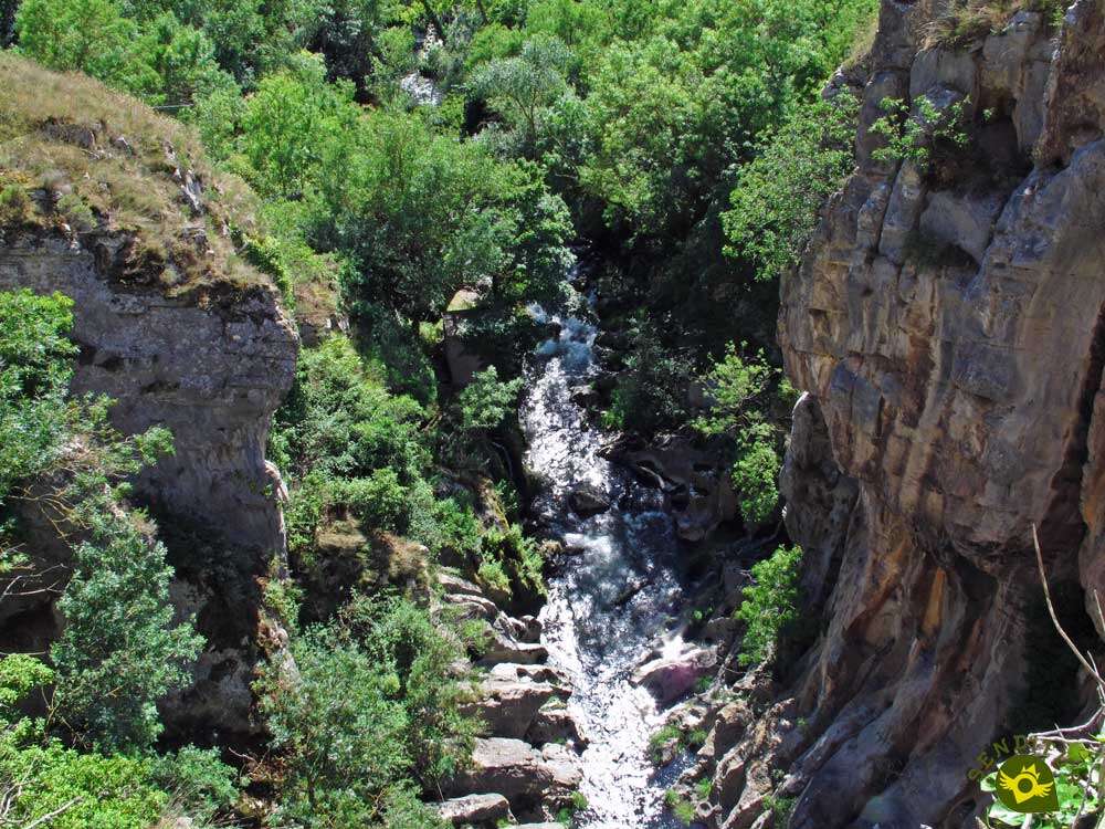
The route starts from the spectacular Bridge of Mother of God, in Anguiano. Along its 2.4 km allows us to travel this ancient path of Muslim roots that served as an access route to the old site that stood here. Accompanied by the route and the GR 93 marks, we will see ourselves contemplating the deep void that falls under the bridge where the route begins. On our way we will be able to discover the old caves that in the wall of the mountain served as shelter to hermits and neighbors. Caves that today give name to one of the neighborhoods that form Anguiano. The Walk of Acera offers us a different perspective of the locality and of the course of the river to its passage by her.

Almost without realizing it, we left behind the detour that follows the Route of Three Towns on its road to Matute, while we followed the steps of the GR 93, well flanked at all times by the banister that delimits the route. After a while, the Marimatea fountain comes out inviting us to take a rest and enjoy its freshness. The route allows us to contemplate the area of Isla, where the Anguiano sports complex is located. Almost without realizing it we arrive at the end of this walkway, marked by the presence of the mysterious Cave Nuño. Under the attentive gaze of the symbolic Clock Rock and letting the GR 93 continue its ascending course, we put an end to our route to return on our steps again to the Bridge of Mother of God, again back to Anguiano.

In case you do not want to return by the same route, we have the possibility to do it by the area of Isla. In order to do this, at the end of the railing that marked the route, we must follow the course of the GR 93 a little more, leaving the Najerilla river behind us. After a few metres, just before the GR 93 begins to ascend, we will find on our right a path that leads us back to the Najerilla river basin. This path goes down to the sewage treatment plant, and from there back to Anguiano through the area of the island where the swimming pools and football field. The more adventurous can also extend the route even further and following the GR 93 route link with the Route of Peñas and visit Nuño Cave, to return to Anguiano through this itinerary.
To the municipality of Anguiano we arrive following the LR-113 that joins Nájera with the town of Salas de los Infantes, also a few kilometres after passing through Anguiano, direction Salas de los Infantes we will find the detour that ascends until the Monastery of Valvanera. This same road, in Nájera, communicates with the A-12, Autovía del Camino and with the N-120, between Burgos and Logroño. There is also a wide schedule of intercity buses that connect Anguiano with both Nájera and Logroño. Once in Anguiano, in the middle of the road that crosses the town, we will find, at the exit of Anguiano towards Monasterio de Valvanera, a parking area where we can leave our vehicle and shortly after the street that brings us to the Bridge Mother of God where the route begins.
A perfect ride to enjoy with our friend, without major complications and with hardly any effort.
Along the way we will find a fountain where our companion can drink if needed.
It is not unusual to find horses along the way, as well as other pets.
 Distance. 2,4Km
The return via the Isla area increases the distance, but should not be a problem.
 Time. 0:35h
If we return to Anguiano through the area of the island we should not notice a big difference, only about 5 minutes more, approximately.
 Time of year
The landscapes and the simplicity of the route make it tempting practically all year round, except for a few days of bad weather.
 Required equipment
Given the wide footpath that follows the route and the apparent simplicity of it does not require large backpacks loaded with material. A pair of sports shoes and some warm clothes if the weather requires it is, in general, how much we will need for this walk. Consult our list of material and equipment for hiking. Read more.
 Difficulty. Low
Physical
Neither the distance, nor the unevenness whose most remarkable ramps we will find at the beginning of the route, should suppose a problem if we dare to make this route.
Severity of the environment
We must not forget that we go to the beginning of the route next to a cliff, so it is not a good idea to leave the marked route. As for the rest, except for some mud in the Marimatea fountain area, and the initial area, which is the steepest of the entire route, there are no a priori major complications.
Orientation
Except for the sign at the beginning of the route, the route of the Walk of Acera does not have its own signposting. We must be guided by the GR 93 marks, although the route is not lost as it is almost entirely delimited by the wooden railing that separates us from the Najerilla riverbed, which runs at our feet. If we decide to return through the Isla area, the path we must follow comes to our right just where some old posts of the old railing are still standing. Here the GR 93 marks warn us that we are abandoning its course to descend towards the water treatment plant where the asphalted track that will return us to Anguiano begins.
 |
 |
 |
 |
 |
| 1-Anguiano | 0:00h | 644m | 0Km | 30T 519230 4678561 |
| 2-Anguiano | 0:35h | 644m | 2.4Km | 30T 519230 4678561 |
Coordinates UTM Datum WGS84

 Slope: 100m
 Slope +: 50m
 Slope -: 50m
 Maximum altitude: 694m
 Minimum altitude: 644m

This sketch of the route is not made to scale nor does it contain all the information relating to the area, it is merely indicative.

![]()
This schematic with the path is approximate and has been created from the derived cartographic base © Instituto Geográfico Nacional "Cuadrante 241-1, 25.000"
Senditur has manipulated the tracks to correct the aberrant points that may exist, caused by problems with the reception of the GPS signal. In any case the tracks are always approximate. SENDITUR encourages you to use the new technologies within your reach, using them as support and consultation in your activity, not basing the realization and orientation of the same only and exclusively on them, since they may see their functioning altered by very diverse causes, not functioning correctly and their indications may not be precise.


Sencillo paseo que discurre en el margen izquierdo del rio Najerilla teniendo una perspectiva frontal del pueblo de Anguiano (Barrios de Mediavilla y Eras). Puedes hacerla circular acabando en las instalaciones deportivas.
Paseo corto y fácil, desde el que se tiene una panorámica frontal del pueblo muy curiosa.

Location of the Virgin of Valvanera, Patron Saint of La Rioja


Cradle of the Castilian and pantheon of the seven Castilian heroes

Emblematic place that reflects the stages of history, art and culture of the area

Find out what to see in...
¿Did you know that...
The term Acera that gives name to this route, according to the studies, comes from the Arabic and means road, of there the name of Walk of Acera.
Don't miss out...
The visit to the church of San Pedro in the district of Cuevas de Anguiano. It is believed that this was the first settlement here, having its old church a great importance back in the tenth and eleventh centuries.


From the commitment of SENDITUR with Nature and the respect to the balance of the environment, SENDITUR urges you to travel in a responsible way, with low environmental impact and respecting at all times the Natural, Cultural and Social environment wherever you go.

.jpg)

Besides sharing with all of us your experience on the route we would be grateful if you could write to us to inform us of any erroneous or outdated information you may have found, or simply to let us know what you think at Thank you.
This route has been carried out in the field by SENDITUR on 29-07-2019. The route may vary greatly depending on the time of year, weather conditions and terrain, as well as the actions of third parties and the evolution suffered in the natural environment where it is located. All opinions, advice and/or assessments made by SENDITUR in their descriptions are for guidance only and are subject to and/or refer to the specific conditions of the specific day of the route, referring to that specific day, taken from trained people, with the appropriate experience and with a high level of physical and technical preparation as a reference, as well as correctly equipped.
All the times are approximate and take an orientative character, the stops have not been taken into account, no matter how small they are. All the information related to the route, texts, images, videos, maps, diagrams, tracks, towns, and places of tourist interest are published as a guide, and may not coincide with the current state of each place. Before undertaking any activity, assess your technical knowledge, your physical condition, find out about the weather and the variations that the route may undergo, equip yourself correctly, be prudent and responsible at all times, and do not exceed your capabilities. SENDITUR is not responsible for any misuse or inappropriate use of the comprehensive guides of its routes and/or publications as well as its electronic guides, nor for any variations in their descriptions for the aforementioned reasons, and recommends that everyone be responsible and prudent in carrying out the activity. We also encourage you to read books and specialised guides to complement the information described above.
Continue watching …


.jpg "Go to Monastery of Valvanera")
.jpg "Go to Caves of Ortigosa")


