Welcome to SENDITUR.COM · paths · routes · tourism

It is an ancient salt mining located in the municipality to which they give their name. They are found in a depression that descends towards the plain of La Bureba, next to the Páramo de Masa, and they give the image of a crater, diapir, which is perfectly visible both for its shape and its size. The diapir is formed by folds caused by structural changes in the terrain where the less dense materials push upwards, breaking up the layers of limestone sedimentation on top of them. This geological phenomenon formed the false crater whose walls instead of lava hold a saline deposit.

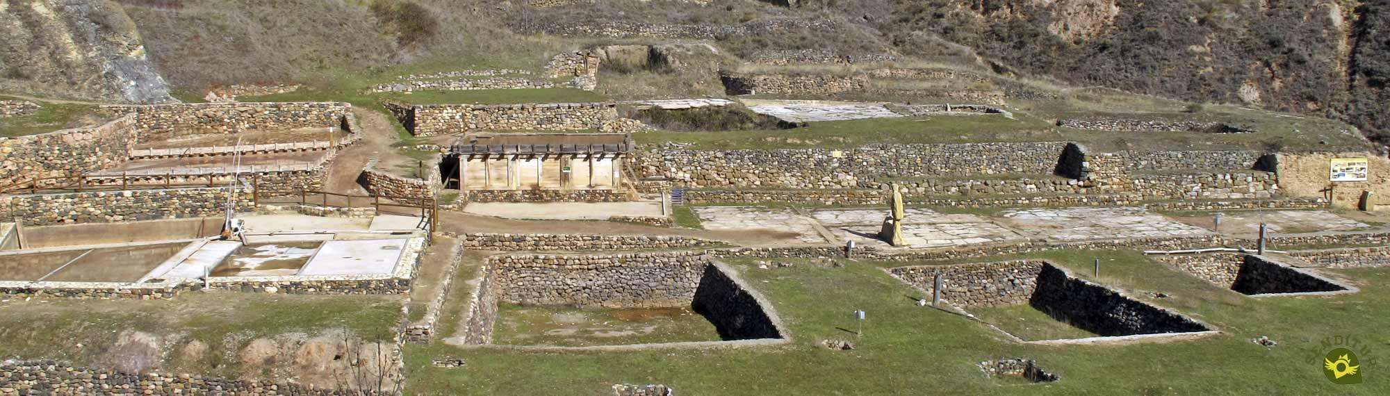
The Salt Flats of Poza de la Sal were exploited by man since Prehistoric times, but it was the Romans who put into practice new methods for obtaining brine, giving it a greater commercial thrust, for this they built bridges and fitted out roads. The first written reference to The Salt Flats of Poza de la Sal are from the 10th century, but the great economic importance that the salt had is reflected throughout history in the eagerness that the kings and nobles had to exercise their control and dominion. In fact in Castile its exploitation was almost always a right of the crown being in times of Philip II, in 1564, when new and more rational methods are established, thus achieving excellent results in its production. The Salt Flats of Poza de la Sal have been exploited until well into the twentieth century, specifically until the year 1970 and currently have been declared an Asset of Cultural Interest as a Historic Site.

The Salt Flats of Poza de la Sal, located in a beautiful natural environment, constitute a unique testimony of one of the most traditional and lasting economic activities in time. They tell the visitor, through a self-guided route with explanatory panels, how were the elements and constructions that were used in this industry and that many of them still survive the passage of time, some of them their ruins and others their reconstructions. Little by little we see eras, huts and shacks, muera storage wells, reeds, galleries... and of course the ruins of the three royal warehouses: the Depósito, which is the oldest building, was built during the reign of Felipe II, the Trascastro and La Magdalena, the latter visible at the top, date from the end of the 18th century. The Casa de Administración de las Reales Salinas is also from the 18th century and is located at the end of the Calle Mayor and today houses the Centro de Interpretación de las Salinas (Salinas Interpretation Centre). In addition, several hiking routes, taking as a link the marked path S.L-BU-67 "Las salt flats of Poza" which is part of the set formed by the washing places and the Fuente Buena and which goes through the diapiro of Las Salt Flats of Poza de la Sal, bring the walker to places where he can appreciate the unique environment and the beautiful peaks of this salt valley.

The work of the salinero and that of the muleteer were complementary. La Cabaña Real de Carreteros, which was founded by the Catholic Monarchs, was in charge for centuries of loading and distributing the salt from Poza to the alfolíes, salt warehouses, of the current provinces of Castilla y León.
The diapiro of Poza de la Sal is a saline outcrop, almost in open sky, that is known by the people of the place as the Saltcellar and that according to geologists is one of the most spectacular, and that better shows how it was formed, of the world.

In Roman times salt was a product that had a high economic value and it is said that the word salary comes from when, 500 years before Christ, they built a road called Via Salaria and that it joined the Ostia salt mines with Castrum Truentinum, in the Adriatic and that the soldiers who guarded this road received part of the pay in salt. This part of the pay was called Salarium Argentum, i.e. salt money.


MORE ROUTES AVAILABLE, DON'T MISS IT...


MORE PLACES AVAILABLE, DON'T MISS IT...


Poza de la Sal can be reached via the CL-663 that connects it with the N-232, in Cornudilla, and through the latter with Pancorbo and Oña. The town is also reached by the BU-502 road, which connects it with neighbouring towns as well as with Briviesca. Poza de la Sal has a regular bus service with a stop at the crossroads at the entrance to the town, which links it with Burgos, Briviesca and Bilbao.
You will find the Salt Flats interpretation centre at Poza de la Sal in the middle of the road that crosses the town and next to it begins the street that leads to the access to the salt flats, under the watchful eye of the monument to Félix Rodríguez de la Fuente. Poza de la Sal has several areas fitted out as car parks where we can park our vehicle and go on foot to the salt flats.
SENDITUR is not responsible for any variation in the information described, as well as for the misuse of its guides and recommends that everyone be responsible and prudent in carrying out the activity. Likewise, we invite you to document yourself with books and specialized guides to complement the information described. From the commitment of SENDITUR with Nature and the respect to the balance of the environment, SENDITUR urges you to travel in a responsible way, with low environmental impact and respecting at all times the Natural, Cultural and Social environment wherever you go. For any suggestion, SENDITUR invites you to send an email to
1:00 h.4 km.

0:30 h.1.5 km.

0:20 h.1.4 km.

3:10 h.10.4 km.

2:45 h.8.8 km.

0:15 h.0.8 km.

96:00 h.393 km.


Great encyclopedia of the evolution of man, natural treasure kept in time

Manganese mines whose exploitation is probably one of the oldest in Spain

According to historians, Alava's best-preserved fortified complex

The largest karstic complex in caves on the Peninsula Ibérica

Continue watching …


.jpg "Go to Natural Monument of Ojo Guareña")

.jpg "Go to Puentedey")

