Welcome to SENDITUR.COM · paths · routes · tourism


![]() Difficulty-Low
Difficulty-Low
![]() 0:20 h.
0:20 h.
![]() 1.4 km.
1.4 km.
![]() Difficulty-Low
Difficulty-Low
![]() 0:20 h.
0:20 h.
![]() 1.4 km.
1.4 km.
The Hoces del Alto Ebro y Rudrón Natural Park treasures incalculable natural and landscape resources that make it, together with its historical, artistic and cultural heritage, an obligatory point of reference to visit. Very close to the small town of Covanera, nourishing with its waters the nearby river Rudrón, is located the Blue Well, a jewel for underwater speleology known worldwide and even without having been explored in its entirety.

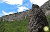
The route with only 1.4 km, part of the coquettish Covanera, to travel the tireless course of the river Rudron as it passes through the town. The river has carved its way through this beautiful valley leaving spectacular rock formations that the wind and rain have been responsible for polishing. Among all these formations there is one that stands out above all, the Perentón. This impressive vertical rock, like a stylized chimney, watches us from its privileged location as we leave behind the pleasant company of the river Rudron and head towards the unique Blue Well. With a known extension superior to the 10 Km, fact that added to his singular characteristics, they have turned to the cave that hides under his waters in all an international reference of the speleobuceo.

This spring of crystalline waters for the great majority of us only offers us a beautiful and colorful spectacle that, together with the place where it is located, more than justifies the visit. In its interior it reserves for a few a territory of underwater galleries and imposing siphons that give way to new galleries, some of them even free of water. Year after year exploration campaigns continue to discover new corners of this colossal cave whose entrance, with the invaluable collaboration of the sun, can be sensed at the bottom of the Blue Well, almost 10 m deep. Once our curiosity has been satisfied, all that remains is to say goodbye to such a mysterious enclave and return again to Covanera, concluding the singular visit.

Legend has it that inside the Blue Well, in the deepest part of the cave, lives a beautiful lady with long hair whose dazzling skin illuminates the dark galleries through which she passes. And legend has it that this damsel in noble robes is actually a noble lady who marched to court to join her beloved when on a stop on the way she fell into the well and was never heard of again. Legend has it that the young woman does not give up in her determination to meet her beloved and every time she feels the presence of a young man on the shore of the Blue Well, she emerges from its depths for an instant until she realizes that the young man is not the one she is waiting for.
Covanera you will find it in the middle of the N-623 that links Burgos with Santander, more specifically in the section between Tubilla del Agua and San Felices del Rudrón. Once there, in the same place where the bus stop is located, the route begins, and we will find a couple of areas where we can park our vehicle. If we decide this way we can also advance with it until the small zone of parking that there is at the beginning of the footpath that leads up to the well.
Perfect route to get used to hiking with our dog, in which the greatest danger is with the traffic of the road just at the beginning of the route.
The simplicity and short distance of this route should not put us in trouble with the water, in addition to the one that we can take we will have several points in which our companion will be able to refresh itself if it was necessary.
The pets that live in the area are, as a general rule, all the additional company that we will surely find.
 HIKING IN BURGOS
TO VISIT IN BURGOS
In the same Covanera (0h 00min), next to the road that leads to this town, begins the route that will bring us to this unique spot.

The bus stop and an old advertising poster mark the beginning of the track we must follow.

We leave behind the car parks that this area offers to cross the river Rudron and follow its descending course that will take us to the next detour.

A comfortable track leads us without major complications to a small parking area snatched from the undergrowth that populates the bank of the river.

It is in this same place where a solitary sign indicates to us the beginning of the footpath by which we will have to continue to cross the little distance that separates us from our final objective.

The wide trail goes up the course of the stream that runs through the Blue Well ravine. A path that will not put us in great trouble to reach this hidden corner of great natural value.

Without hardly noticing it, we will meet at the bottom of the ravine where the famous Blue Well awaits us (0h 10min).

Once you have enjoyed this curious place, all you have to do is retrace your steps to get back to Covanera (0h 20min) and finish this hiking route.
 Distance. 1.4Km
Where we manage to park our vehicle to start the route will mark the distance to be covered.
 Time. 0:20h
This time may vary in part depending on the starting point we choose as we will have several parking areas to which closer to the Blue Well.
 Time of year
Generally during the whole year we will be able to enjoy this place, although logically they will be the months of greater level of the rivers in which we will find the well in all its splendor.
 Required equipment
The relative simplicity of the route and its short distance allow us to go light, but without forgetting the recommendations that are always interesting to bear in mind, appropriate footwear will provide us with greater comfort. Consult our list of material and equipment for hiking. Read more.
 Difficulty. Low
Physical
Even assuming the route in its totality, we are before a route that should not suppose any problem given its scarce slope and its small distance.
Severity of the environment
As long as we do not leave the route we will not have more complications than the little traffic that we will find in the stretch of track. Attention in the area of the well if we venture to look for different perspectives climbing to the cliff, it is easy to take a bad step.
Orientation
The greatest difficulty is to be found at the beginning of the route, or rather to locate its beginning on the road. Once there, the few crosses are well signposted and the itinerary leaves no room for doubt.
 |
 |
 |
 |
 |
| 1-Covanera | 0:00h | 692m | 0Km | 30T 434468 4731885 |
| 2-Blue Well | 0:10h | 703m | 0.7Km | 30T 434827 4731789 |
| 3-Covanera | 0:20h | 692m | 1.4Km | 30T 434468 4731885 |
Coordinates UTM Datum WGS84

 Slope: 86m
 Slope +: 43m
 Slope -: 43m
 Maximum altitude: 714m
 Minimum altitude: 692m

This sketch of the route is not made to scale nor does it contain all the information relating to the area, it is merely indicative.

![]()
This schematic with the path is approximate and has been created from the derived cartographic base © Instituto Geográfico Nacional "Cuadrante 0135-3, 1:25.000"
Senditur has manipulated the tracks to correct the aberrant points that may exist, caused by problems with the reception of the GPS signal. In any case the tracks are always approximate. SENDITUR encourages you to use the new technologies within your reach, using them as support and consultation in your activity, not basing the realization and orientation of the same only and exclusively on them, since they may see their functioning altered by very diverse causes, not functioning correctly and their indications may not be precise.


Es un paseo que merece la pena


The largest karstic complex in caves on the Peninsula Ibérica

Find out what to see in...
¿Did you know that...
Since 1964, approximately, dives have been carried out in this cave that have been discovering new galleries year after year, in addition to beating several world records of distance in cave diving, even today the discovered map of this important cave is still being enlarged.
Don't miss out...
The Natural Park of Hoces del Alto Ebro and Rudrón, whose rich natural and cultural heritage ranges from ancestral dolmens and ancient huts to well-kept Romanesque hermitages and welcoming villages that merge with the beautiful landscapes formed by the sickles and the impressive corners they hide.


From the commitment of SENDITUR with Nature and the respect to the balance of the environment, SENDITUR urges you to travel in a responsible way, with low environmental impact and respecting at all times the Natural, Cultural and Social environment wherever you go.

Besides sharing with all of us your experience on the route we would be grateful if you could write to us to inform us of any erroneous or outdated information you may have found, or simply to let us know what you think at Thank you.
This route has been carried out in the field by SENDITUR on 30-07-2016. The route may vary greatly depending on the time of year, weather conditions and terrain, as well as the actions of third parties and the evolution suffered in the natural environment where it is located. All opinions, advice and/or assessments made by SENDITUR in their descriptions are for guidance only and are subject to and/or refer to the specific conditions of the specific day of the route, referring to that specific day, taken from trained people, with the appropriate experience and with a high level of physical and technical preparation as a reference, as well as correctly equipped.
All the times are approximate and take an orientative character, the stops have not been taken into account, no matter how small they are. All the information related to the route, texts, images, videos, maps, diagrams, tracks, towns, and places of tourist interest are published as a guide, and may not coincide with the current state of each place. Before undertaking any activity, assess your technical knowledge, your physical condition, find out about the weather and the variations that the route may undergo, equip yourself correctly, be prudent and responsible at all times, and do not exceed your capabilities. SENDITUR is not responsible for any misuse or inappropriate use of the comprehensive guides of its routes and/or publications as well as its electronic guides, nor for any variations in their descriptions for the aforementioned reasons, and recommends that everyone be responsible and prudent in carrying out the activity. We also encourage you to read books and specialised guides to complement the information described above.
Continue watching …


.jpg "Go to Natural Monument of Ojo Guareña")