Welcome to SENDITUR.COM · paths · routes · tourism


![]() Difficulty-Low
Difficulty-Low
![]() 0:15 h.
0:15 h.
![]() 0.8 km.
0.8 km.
![]() Difficulty-Low
Difficulty-Low
![]() 0:15 h.
0:15 h.
![]() 0.8 km.
0.8 km.
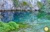
In the foothills of the Natural Monument of Ojo Guareña, between the towns of Puentedey and Quintanilla Valdebodres, embedded in the narrow ravine that has been forming the effect of water and air in the rocks, the Waterfall of La Mea falls into a vacuum. A capricious waterfall that feeds on the waters collected by the Canales de la Dulla, up the mountain.

The route with just 800 m round trip, starts from a small car park next to the road that joins Puentedey and Quintanilla Valdebodres, to go up the ravine formed by the river from its widest part to its interior. A pleasant walk among gall oaks, ashes, maples and hawthorns, surrounded by the imposing limestone cliffs from which the stream we are climbing escapes. The spectacle of the characteristic karstic complex that defines this area of The Merindades has in this place a worthy representative like a capricious waterfall and the singular rock formations that accompany it. The Waterfall of La Mea gives us the unique opportunity to enter into its entrails bordering its fine curtain of water to contemplate the panoramic view from inside, having over our heads the imposing cornice of rock that has been forming over the years.

But this will certainly not be the only thing that flies over our heads, griffon vultures and eagles will watch us attentively from the heights, as if they were protectors of this natural treasure. Undoubtedly the impressive rock formations are in themselves a great attraction, to which the most propitious months is added this beautiful waterfall to together make this route an indispensable stop on our way. Once we have enjoyed this hidden corner of the Merindad de Sotoscueva, all that remains is for us to return on our steps to the car park, the starting point of this simple and interesting route.

Legend has it that in the lands of the River Guareña, near the hermitage and the cave of San Bernabé, there was a ruthless peasant who ground his oxen with sticks every time he plowed his fields with them. One day the animals, fed up with their bloodthirsty owner, came out like the devil's soul with such bad luck for the peasant that when he tried to hold them he was dragged by the beasts without being able to get rid of the straps that caught him. The animals, out of themselves, rushed to the plentiful channel of the stream that ran with force towards the famous Sumidero del Guareña by which they were dragged and with them the labrador. A few days later, when everyone already considered them dead, on the other side of the mountain, in Quintanilla Valdebodres, from the Well of Hell, only the two oxen appeared, united even by the brabán, without anything else being known about the ruthless peasant.
To get to Quintanilla Valdebodres we can do well from Puentedey, in which case before reaching Quitanilla de Valdebodres we will find the small car park from where the route begins. Or we can also do it from Ahedo de Linares and Cogullos, towns of the merindad up to the ones that arrive two roads coming from the well-known hermitage and cave of San Bernabé, in Ojo Guareña, and from the nearby towns. In this case, once in Quintanilla Valdebodres, continue along the road that leads to Puentedey to reach the car park.
Simple hiking route for our friend that will allow you to enjoy the journey without complications, just pay more attention in the parking area to be flush with the road.
Without water, except the one that can take the river that in addition does not have an easy access nor in many occasions it is advisable to do it, is the little distance the one that gives us the sufficient margin, whenever we take water in the car.
Except for the shy fauna of the area, which is usually difficult to see, we only find a few pets that may also be doing this short route.
 Distance. 0.8Km
Unless we are forced to park our vehicle far from the car park at the start of the route, the distance to be covered should not be much more than the marked distance.
 Time. 0:15h
With no other option than to follow the marked route this figure should not vary too much, beyond the time that we dedicate to enjoy the place.
 Time of year
It goes without saying that without enough water the route loses one of its greatest attractions, although the spot itself is also worth visiting. It is therefore important to coincide with the periods in which the waterfalls come down with water, in order to enjoy the attractiveness of the area to the full.
 Required equipment
A walk that can be enjoyed without much more to highlight, except the advisable idea of doing it wearing appropriate shoes, hiking type, which will give us greater comfort and safety. The camera will also be a good companion without forgetting the usual recommendations indispensable for any small tour that is. Consult our list of material and equipment for hiking. Read more.
 Difficulty. Low
Physical
The short distance and the small slope to overcome make this route a simple challenge to which we can devote the necessary time so that we do not suppose greater efforts.
Severity of the environment
We walk in the middle of a wide ravine surrounded by enormous cliffs that if we look closely we will see how some stones have fallen off, although it is not normal is not impossible to happen again. On the other hand, the trail is not very complicated except for a short, somewhat slippery stretch. Attention in the environment of the waterfall especially if the ground is wet.
Orientation
The biggest complication we have to find is not skipping the beginning of the path and parking area when we approach with the car, as it is only signposted by a lonely post that can easily pass us by. For the rest the footpath takes us without more possible option, whenever we do not leave its layout, to descend to the course of the river Mea.
 |
 |
 |
 |
 |
| 1-Parking | 0:00h | 647m | 0Km | 30T 445019 4758834 |
| 2-Waterfall of Mea | 0:10h | 691m | 0.4Km | 30T 444799 4759128 |
| 3-Parking | 0:15h | 647m | 0.8Km | 30T 445019 4758834 |
Coordinates UTM Datum WGS84

 Slope: 88m
 Slope +: 44m
 Slope -: 44m
 Maximum altitude: 691m
 Minimum altitude: 647m

This sketch of the route is not made to scale nor does it contain all the information relating to the area, it is merely indicative.

![]()
This schematic with the path is approximate and has been created from the derived cartographic base © Instituto Geográfico Nacional "Cuadrante 0109-2, 1:25.000"
Senditur has manipulated the tracks to correct the aberrant points that may exist, caused by problems with the reception of the GPS signal. In any case the tracks are always approximate. SENDITUR encourages you to use the new technologies within your reach, using them as support and consultation in your activity, not basing the realization and orientation of the same only and exclusively on them, since they may see their functioning altered by very diverse causes, not functioning correctly and their indications may not be precise.


Cuando lleva agua es un pasada!!

The largest karstic complex in caves on the Peninsula Ibérica


Find out what to see in...
¿Did you know that...
The toponym Valdebodres, from Quintanilla, may be due to the typical wineskins in which the wine was stored and which were made with the skins of goats, an animal that until recently was very often seen as part of the herds owned by farmers in the area.
Don't miss out...
The Hell's Well that you will find in the nearby village of Quintanilla Valdebodres, is a natural spring of water that springs in the middle of the village. The first part of this cavity is just over a hundred metres deep, barely 20 percent of which has been explored, but it is still being extended by another 250 metres in its second area.


From the commitment of SENDITUR with Nature and the respect to the balance of the environment, SENDITUR urges you to travel in a responsible way, with low environmental impact and respecting at all times the Natural, Cultural and Social environment wherever you go.

Besides sharing with all of us your experience on the route we would be grateful if you could write to us to inform us of any erroneous or outdated information you may have found, or simply to let us know what you think at Thank you.
This route has been carried out in the field by SENDITUR on 15-07-2016. The route may vary greatly depending on the time of year, weather conditions and terrain, as well as the actions of third parties and the evolution suffered in the natural environment where it is located. All opinions, advice and/or assessments made by SENDITUR in their descriptions are for guidance only and are subject to and/or refer to the specific conditions of the specific day of the route, referring to that specific day, taken from trained people, with the appropriate experience and with a high level of physical and technical preparation as a reference, as well as correctly equipped.
All the times are approximate and take an orientative character, the stops have not been taken into account, no matter how small they are. All the information related to the route, texts, images, videos, maps, diagrams, tracks, towns, and places of tourist interest are published as a guide, and may not coincide with the current state of each place. Before undertaking any activity, assess your technical knowledge, your physical condition, find out about the weather and the variations that the route may undergo, equip yourself correctly, be prudent and responsible at all times, and do not exceed your capabilities. SENDITUR is not responsible for any misuse or inappropriate use of the comprehensive guides of its routes and/or publications as well as its electronic guides, nor for any variations in their descriptions for the aforementioned reasons, and recommends that everyone be responsible and prudent in carrying out the activity. We also encourage you to read books and specialised guides to complement the information described above.
Continue watching …


.jpg "Go to Natural Monument of Ojo Guareña")