Welcome to SENDITUR.COM · paths · routes · tourism


Path of the Ventanón
Merindad de Sotoscueva, Burgos![]()
![]()
![]()
![]()
![]() (1)
(1)
Works of art that nature shapes year after year
![]() Difficulty-Medium
Difficulty-Medium
![]() 2:40 h.
2:40 h.
![]() 10.4 km.
10.4 km.
Merindad de Sotoscueva, Burgos![]()
![]()
![]()
![]()
![]() (1)
(1)
Works of art that nature shapes year after year
![]() Difficulty-Medium
Difficulty-Medium
![]() 2:40 h.
2:40 h.
![]() 10.4 km.
10.4 km.
The incomparable setting of the Natural Monument of Ojo Guareña is the setting chosen by the Path of the Ventanón to bring us closer to this whim of nature, one of the many treasures guarded by this natural space. Plains populated with holm oaks, mountains with curious silhouettes, caves of singular geological and historical importance or capricious rock formations, such as the Ventanón, are some of the jewels that this region offers to those who visit it.

The route with its 10.4 km allows us to enter this true natural monument starting from one of its unmistakable symbols, the hermitage and the cave of San Bernabé, which together with the Guareña drain form a karstic complex of incalculable value. We are in front of one of the largest sets of caves on the peninsula that to its geological importance must be added the historical to have been discovered in them several shrines and prehistoric remains. The route will allow us to discover one or another chasm, which will undoubtedly take us for an instant out of the landscape that surrounds us, to make us imagine the labyrinthine subsoil that we are treading. Landscape in which the jagged mountains give way to wide and gentle plateaus in which grow holm oaks and pasta with parsimony the cattle. Mountains such as the Peak of the Horn to which we can approach to contemplate from its privileged top the landscape that dominates from it. The route transports us through the moor, leaving us aside, at least for the moment, the small town of Villamartín to continue in search of the surprising corner that awaits us. The imposing Dulla peak watches us attentively hiding its marked channels, which fall on its other side.

The route has made us accustomed to the characteristic landscape that surrounds us as if it wanted to contribute to the shocking and pleasant surprise that invades us when we arrive at the Ventanón. This imposing stone bridge, which is kept in delicate balance, is a real window to the valley that runs downhill. Enjoyed with calm of this corner also known as The Window of Burgos, we returned to the well-known landscape that brought us up to here to set course towards our next stop. The route gives us the curious formations that the mountains draw, making our journey more enjoyable. Villamartín de Sotoscueva welcomes us with the calm that this quiet locality transmits, while we walk its streets in search of the continuation of the path that has to return us to our starting point. The route bids farewell to Villamartín to undertake the gradual ascent that will return us first to the path that led us to the Ventanón and quickly to the crossroads with the Pico del Cuerno route, which tempts us again with its nearby summit. From there we have the cobbled descent that will bring us closer to the Concha Pass where the car parks are located to visit the cave and hermitage of San Bernabé, and where we begin and end this path of the Ventanón.

Legend has it that the caves of Ojo Guareña were inhabited by witches and even the devil himself, disturbing the quiet life of the peasants in the area. These, tired of the hardships they endured, entrusted themselves to Saint Barnabas, who went into the caves to expel such evil presences. The witches fled in terror, but the devil faced the Saint who locked him forever in the deepest part of the caves, thus ridding the region of the misdeeds they suffered. Since then, prisoner of wrath, the days of storm can be heard amplified by The Ventanón the rabid roars of the devil cursing his destiny.
To get to the small town of Cueva, before the Ojo Guareña complex formed by the hermitage and the cave of San Bernabé, we have to do it through the BU-526 road that joins the national N-232, at Soncillo, with the N-629 in Bercedo. Both national ones communicate Santander and Laredo, respectively, with Oña and later with Pancorbo in the N-1. It is in this BU-526 where after passing through Espinosa de los Monteros, Quintanilla del Rebollar or Pedrosa de Valdeporres, Vallejo de Sotoscueva depending on our point of origin, we will find the road that leads to Cueva, from there ascend to Ojo Guareña where we will have, in its highest part, parking areas near the initial point of the route. Through this same road but by its other slope, following local roads, we can also reach Ojo Guareña from towns such as Villarcayo or Puentedey among others.
It is a demanding route that our friend must face, so we will have to assess well if it adapts to its characteristics. We are on a karstic terrain where the chasms are more abundant than we think and although the ones we pass close are fenced we should not let our dog run at his choice. In addition to our passage by Villamartín we will have to be attentive to the possible vehicles with which we could be found.
The lack of water points or areas along almost the entire route, except at the beginning and passing through Villamartin, forces us not to leave in the car its ration of water and of course food.
The cattle and some other dog loose in the locality is, as a general rule how much we have to find in this route since the local fauna does not usually let itself be seen with facility.
At the same level of the road by which we arrived until here, just before beginning the descent that would take us until the hermitage and the cave of San Bernabé (0h 00min), is the beginning of the route that will approach us until The Ventanón of Burgos.

We leave behind the road and the car parks next to it to begin a strenuous ascent through a, for now, blurred pathway. The paved and arid layout contrasts with the lush vegetation that grows on both sides of the path.

We continue ascending following at all times the marked way that will guide us in great part of the route.

Shortly after walking, when the slope seems to give us a little respite, we find ourselves in front of us with the path that if we follow it would bring us closer to the nearby Cuerno Peak, from which we can see some privileged views of the valley.

We continue with our route, postponing the visit to this beautiful summit for our return. In front of us awaits a long stretch following the winding path.

The slope refuses to abandon us although it is no longer as evident as in the previous ramps.

We soon arrived at a gate that prevents animals and vehicles from passing, a gate that we must cross to continue our route.

Almost at the moment a solitary post on the side of the path indicates our arrival at the Bifurcation (0h 20min), where, if we continue on our left, we would reach Villamartín.
We therefore follow the path that brought us here and that continues with its unalterable course.

Once again we see ourselves alternating zones where vegetation seems to engulf the path with other more open ones that allow us to contemplate the landscape that surrounds us.

There are several chasms next to which we are going to pass as we advance towards our main objective. The slope sometimes becomes more demanding making our progress more uncomfortable.

On some occasions we have to find crosses or roads that put us in doubt of which of them to follow, forcing us to sharpen the view to locate the brand that takes us out of our doubts.

The mountains, whose silhouettes we can contemplate in the horizon, take us out of the monotonous landscape that surrounds us contributing its special beauty to the route.

We continue to gain height with each step without anything to make us intuit the unique place we are about to arrive.

After a long walk, the tiresome slope seems to have come to an end, leaving us before a wide plain with hardly any vegetation, but in which the path seems to fade away covered by the dry grass.

Again and after some time crossing this plain, when our way seems to come to an end, another solitary post appears on our right, signaling the detour towards the Ventanón (1h 05min), which we take without delay.

Once again we see ourselves following a, for now, marked path that seems to make us go backwards.

But nothing further from reality, almost at the moment the road practically disappears under our feet, leaving us with no reference to follow. Luckily, to our left is a small post that invites us to walk towards it.

When we reach its height, we will find the well-defined route as a wide path that will guide us without further complications.

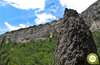
Suddenly the imposing formation known as The Ventanón (1h 10min) appears before us, radically changing the landscape that had accompanied us up to here.
Once we have calmly contemplated the spectacle offered by this work of art of nature, we set our course towards our next objective, returning in our footsteps.

In a few minutes we will be again in the detour that we take towards the Ventanón, where we will have to decide if to return by the same route by which we arrived from the parking lot until here or to direct us towards Villamartín, extending a little the route.

If this is the case, we head towards the mountains, crossing the moor through which we arrived at this detour.

At the moment the path becomes well visible again making us an improvised guide. The route seems determined to bring us closer to the vertical rocks that crown the mountains in front of us.

But when its slope seems closer and closer, the route radically changes direction at the same time as the path disappears, forcing us to take as a reference to rediscover its course the mountain range that hides Ojo Guareña and a solitary post on our left, from those who indicate the route.

Once the path has been taken up again, we advance with the mountains, towards which we were heading, to our right, while we leave them little by little behind.

Our way joins a marked track in which we coincide again with new trails that cross these lands.

In front of us is a long journey in which the wide dirt track and boulders will be in charge of accompanying us.

We will have almost nowhere where we can get to doubt the way forward, rather we will have to decide which of the two options to follow to get to the same point, a little later.

On the contrary, there will be several paths that will join us as we travel the distance that separates us from the locality to which we are heading.

After a while, among the treetops, the tower of the church of Villamartín shows up and warns us of its next arrival.

We descend leaving behind the cemetery of the locality, to shortly after say goodbye to GR 1 and the Path of the Dulla Canals that continue their course.

We continue the descent that will introduce us definitively in Villamartín de Sotoscueva (1h 50min).
We continue our walk through the town leaving behind the road that reaches it from Ojo Guareña.

We go along the main street, as if the route did not want us to leave Villamartín yet.

However, this is not the case, as as soon as we cross a small square, it will be time to say goodbye to the locality. The route leaves the main street to follow a narrow alley that leads to a kind of old field.

In front of us, almost hidden by the vegetation, we have the mark of the route, and the path where the route continues.

We began to gain altitude to quickly find ourselves with a rudimentary cattle gate. As soon as we cross it, our route turns radically making us continue on the right instead of the apparent path that continues to ascend.

This entire section requires some attention to find and follow the markings that indicate the correct course.

In some cases the vegetation and in others the state of some areas, make the path or trail to follow is not as clear as on previous occasions.

Even so, the path to follow is intuited with some ease in most cases. Now we must gain the height lost in the descent that led us to Villamartin.

The thick vegetation and the state of the land make it difficult in some areas to follow the course of the route. There are not many junctions that we have to find, but they will surely make us doubt until we find the corresponding mark.

The route continues its course with a view of the characteristic mountain range that is home to Ojo Guareña.

The path continues to put us in difficulty by offering us different alternatives that would surely also bring us closer to our destination but which are not officially marked.

We continue with the hard ascent that leads us to the meeting of the path that led us to El Ventanón de Burgos.

The slope seems to soften almost at the same time that we see ourselves crossing the bushes and holm oaks in search of the nearby crossroads.

Almost without noticing it, we come across the Bifurcation (2h 25min), where we join the path that comes from Ojo Guareña.

From here we only have to follow our steps that will take us to the crossroads with the path of the Cuerno Peak, which if we decide so we can approach.

From this junction we will head towards the car park next to the hermitage and the cave of San Bernabé (2h 40min) where we begin and end the path of the Ventanón.
 Distance. 10,4Km
If we return by the same route from the Ventanón we will save some distance.
 Time. 2:40h
Althoug:we take the decision to return by the same way we arrived at the Ventanón of Burgos we should not notice a great difference in the time used for the route, that in any case would be reduced in approximately 20 min if we take into account not only the smallest distance but also the most favorable terrain that we will cover.
 Time of year
Wit:bad weather and fog we will lose muc:of the attraction offered by this route, as is the beautiful landscape that surrounds us, as well as being exposed to inclement weather. Winter has its great attraction but snow or ice can make the itinerary very difficult.
 Required equipment
The protection against the sun, especially on hot days, can not be missing because we will not have many shaded areas along the route. Nor the canteen and some food should be missing in our backpack, where they accompany the usual, first-aid kit, short wind clothing and raincoat ... The canes and camera will surely be other good travel companions. Unless the weather conditions discourage it, we can use trekking shoes. Consult our list of material and equipment for hiking. Read more.
 Difficulty. Medium
Physical
Wit:an already important distance to whic:is added the slope, gentle except on a couple of ramps, we are faced wit:an entity route that will require us to be in relatively good physical shape so that it does not seem harder than it really is.
Severity of the environment
When driving along paths throug:the wide paramo it is the paving of some stretches that may make us uncomfortable, making us advance more carefully to avoid sprains, as long as we do not leave the route, in whic:case it is not so strange that we find some chasm or hole, althoug:the nearest are usually fenced. The Ventanón invites you to lean out of its lintel, an act that would not be more dangerous, as long as we do not cross the limits marked by the fence, other than the fact that the stones and boulders beneat:it remind us that we are not exempt from falling stones.
Orientation
Quite well signposted and its layout defined in almost all the route, it is in the section that goes from Villamartín to the fork where bot:routes join where we have to find greater complications. In fact, it is easy to miss and deviate from the pat:to follow, partly because of the state of the signposting, whic:is scarce and hidden by the vegetation in many cases, and partly because of how poorly defined the pat:is in some areas, making it more difficult to follow. In this section we will have to be more attentive and look for the typical marks in stones and trees that mark the path. Nor should we be mistaken about the many hiking routes that run throug:this area of Burgos, GR, PR and local trails wit:whic:we are going to coincide along the route.
 |
 |
 |
 |
 |
| 1-Cave and hermitage of San Bernabé | 0:00h | 769m | 0Km | 30T 445879 4764732 |
| 2-Bifurcation | 0:20h | 837m | 1.1Km | 30T 444931 4764726 |
| 3-Detour to the Ventanón | 1:05h | 977m | 4.3Km | 30T 441987 4763744 |
| 4-The Ventanón | 1:10h | 978m | 4.6Km | 30T 441907 4763932 |
| 5-Detour to the Ventanón | 1:15h | 977m | 4.9Km | 30T 441987 4763744 |
| 5-Villamartín | 1:50h | 800m | 7.6Km | 30T 444160 4763516 |
| 7-Bifurcation | 2:25h | 837m | 9.3Km | 30T 444931 4764726 |
| 8-Cave and hermitage of San Bernabé | 2:40h | 769m | 10.4Km | 30T 445879 4764732 |
Coordinates UTM Datum WGS84

 Slope: 630m
 Slope +: 315m
 Slope -: 315m
 Maximum altitude: 980m
 Minimum altitude: 769m

This sketc:of the route is not made to scale nor does it contain all the information relating to the area, it is merely indicative.

![]()
This schematic wit:the pat:is approximate and has been created from the derived cartographic base © Instituto Geográfico Nacional "Cuadrante 084-3 y 084-4 1:25.000"
Senditur has manipulated the tracks to correct the aberrant points that may exist, caused by problems wit:the reception of the GPS signal. In any case the tracks are always approximate. SENDITUR encourages you to use the new technologies within your reach, using them as support and consultation in your activity, not basing the realization and orientation of the same only and exclusively on them, since they may see their functioning altered by very diverse causes, not functioning correctly and their indications may not be precise.


Lo visite hace algunos años y me gusto mucho, toda esa zona de Ojo Guareña es muy bonita.

The largest karstic complex in caves on the Peninsula Ibérica


Find out what to see in...
¿Did you know that...
In the Natural Monument of Ojo Guareña you can also visit the Palomera Cave, it is a total route of about 2492 m through different rooms and galleries where they highlight the variety of elements of geological, archaeological and faunistic interest they have.
Don't miss out...
It goes without saying that it is impossible not to visit the nearby hermitage and cave of San Bernabé, which together with the Guareña drain form an impressive karstic complex, a true natural monument, an unmistakable symbol of this region of Burgos.


From the commitment of SENDITUR with Nature and the respect to the balance of the environment, SENDITUR urges you to travel in a responsible way, with low environmental impact and respecting at all times the Natural, Cultural and Social environment wherever you go.

Besides sharing with all of us your experience on the route we would be grateful if you could write to us to inform us of any erroneous or outdated information you may have found, or simply to let us know what you think at Thank you.
This route has been carried out in the field by SENDITUR on 31-07-2016. The route may vary greatly depending on the time of year, weather conditions and terrain, as well as the actions of third parties and the evolution suffered in the natural environment where it is located. All opinions, advice and/or assessments made by SENDITUR in their descriptions are for guidance only and are subject to and/or refer to the specific conditions of the specific day of the route, referring to that specific day, taken from trained people, with the appropriate experience and with a high level of physical and technical preparation as a reference, as well as correctly equipped.
All the times are approximate and take an orientative character, the stops have not been taken into account, no matter how small they are. All the information related to the route, texts, images, videos, maps, diagrams, tracks, towns, and places of tourist interest are published as a guide, and may not coincide with the current state of each place. Before undertaking any activity, assess your technical knowledge, your physical condition, find out about the weather and the variations that the route may undergo, equip yourself correctly, be prudent and responsible at all times, and do not exceed your capabilities. SENDITUR is not responsible for any misuse or inappropriate use of the comprehensive guides of its routes and/or publications as well as its electronic guides, nor for any variations in their descriptions for the aforementioned reasons, and recommends that everyone be responsible and prudent in carrying out the activity. We also encourage you to read books and specialised guides to complement the information described above.
Continue watching …


.jpg "Go to Natural Monument of Ojo Guareña")