Welcome to SENDITUR.COM · paths · routes · tourism

![]() Difficulty-Moderate
Difficulty-Moderate
![]() 2:35 h.
2:35 h.
![]() 9.4 km.
9.4 km.
![]() Difficulty-Moderate
Difficulty-Moderate
![]() 2:35 h.
2:35 h.
![]() 9.4 km.
9.4 km.
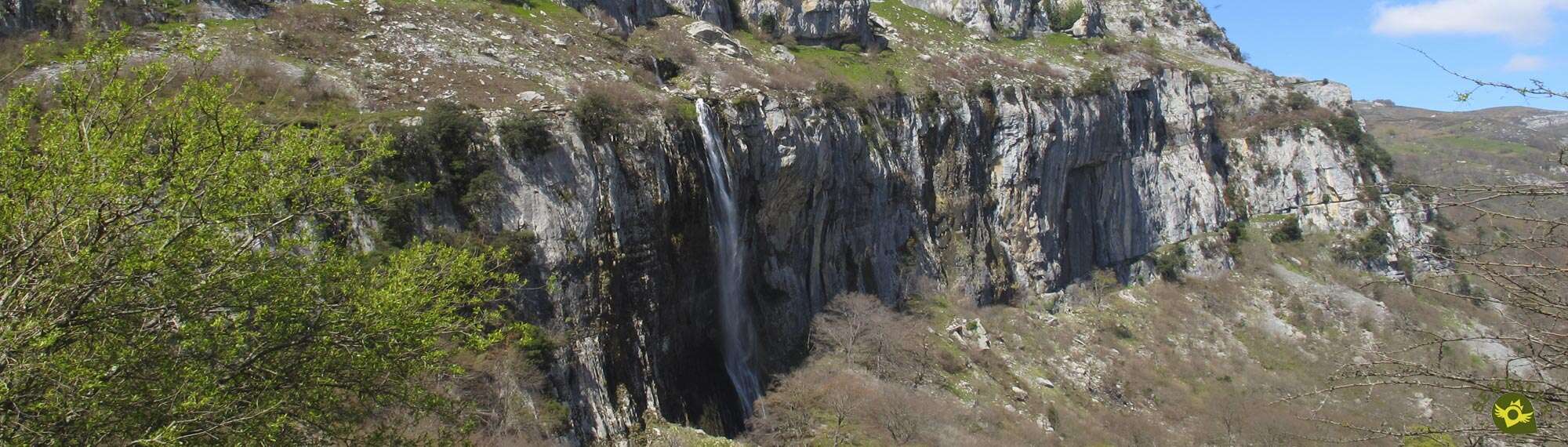
The Alto Asón region contains among its great treasures the Natural Park of the Collados del Asón, a space of great value in which to contemplate the remains of millenary and extinct glaciers, fertile valleys and forests, together with unexplored and important caves. A landscape created to a great extent by the tireless action of the ice and the rivers that have been sculpting and giving their character to these lands. Rivers such as the Asón that springs from the mountain wall to plunge into the void in a spectacular waterfall, the Birth of the Asón River.

The route of the birth of Asón River or Asón Trail as it is also known, with its 9.4 km, will take us following the course of the river from the town of Asón. An indispensable hiking route in Cantabria that combines the spectacular landscapes with the natural wealth of flora and fauna that find in these lands an ideal habitat. The old San Antonio neighbourhood with its small church, takes us out of the comfort provided by the track that leads us to it to enter fully into the heart of the valley, a valley through which time seems not to have passed. A valley of green meadows surrounded by colossal and vertical mountains, meadows in which solitary huts alternate that speak to us of part of the history lived in this region. A singular land that has resulted in a great variety of plant species, including some that are unusual in the Cantabrian coast, such as holm oaks, which share land with hazelnuts and chestnut trees, even today used by the locals. Its special climatology together with the singularity of the glacial origin of this region add a greater attraction, if possible, to this already interesting route. Soon we will see ourselves furrowing the leafy forests of the high zone of the valley, while we decide for some of the different options that from the Bifurcation of the route are posed to us.

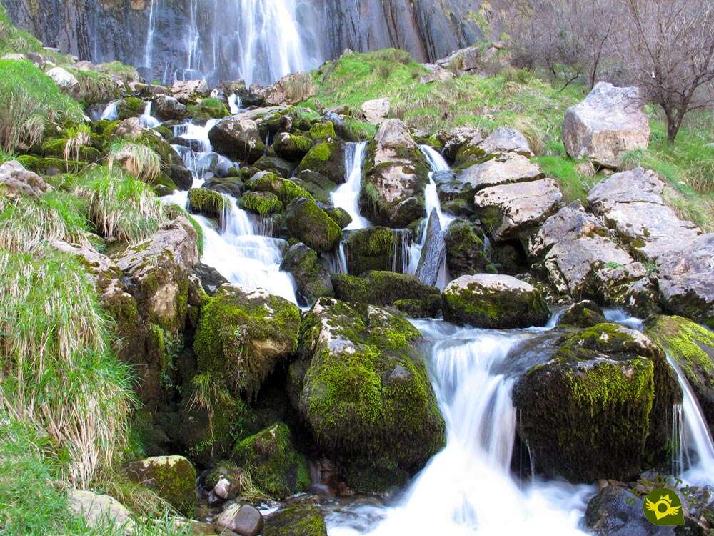
The river, clear protagonist of part of the route, leads us through an amusing labyrinth of large stones, small streams and robust trees in search of one of the signs of identity of this region, the Waterfall of the Ason, or as it is also known the Cailagua. A vertiginous waterfall in the same instant that this flows from the cold rock, resulting in the beautiful spot chosen for the birth of the Asón River. Above our heads and at our feet the complex karstic framework that the glaciers and rivers have been sculpting and that today forms the Collados del Asón Natural Park. We cannot resist looking out over the base of the waterfall, nor let time go by contemplating the tireless and silky fall of the water before the hard and obligatory farewell to resume the path that will take us, by the route we choose from the two existing ones, back to the San Antonio neighbourhood, and later to Asón, where we will stop and follow our visit to this magnificent region.

Many years ago, in a cave close to where Cailagua is today, lived two young Ajanas (sorceresses) with long and silky manes, one of them, the youngest, was famous for performing multiple mischiefs to the people and animals of the place. One night her sister, tired of the many complaints that came to her, decided to make an example of the mischievous girl. While she was sleeping and thanks to her magical powers, she took her to the cave where the river Asón flowed to flow docilely along the slope of the mountain. Once there he cast the spell to shut his sister up, not realizing that her hair was floating in the air outside the cave. Soon the water soaked the young woman's hair and stopped flowing down the hillside to precipitate into the void from the cave like a ponytail. At the end of the days she returned to free her from the humiliation and what was her displeasure when she was not able to remember the spell that freed her sister. Since then the two ajanas have been locked up, one in the cave through which the river flows before plunging into the void and the other at the bottom of Lake Brenavinto where, it is said, there is a large library of spells and enchantments in which the ajana tirelessly searches for the spell she releases from her mischievous sister.
To get to Asón we can do it following the CA-261 road that joins Ramales de la Victoria with Solares to Arredondo, where we must follow the CA-265 that communicates this town with Asón. Also by this same road but in the opposite direction we can reach Asón from La Gándara and from the nearby province of Burgos. Once there, on the outskirts of Asón, as you leave towards La Gándara, you will find the car parks where you can leave your vehicle. Out of season we can also approach it to the San Antonio neighbourhood and leave it parked there.
Entertaining route for our friend in which you will be able to enjoy almost at will without having to suppose a great physical effort, as long as this one accustomed to this type of routes. We must take extreme precautions not only in the short stretch of road, also in the wades of the streams and the river, whose current in many cases is strong enough to give us a displeasure if we let him take a refreshing bath.
On the other hand the water should not be a problem, but it is not too much to bring something, especially in summer, just in case. Food cannot be missing either, although initially it is a not very long hiking route but it will take time to enjoy the places it covers.
The cattle, the dogs that live there and the local fauna, will have their moment along the route so we must be careful to avoid surprises, also we can not forget that we are in a natural park with its specific regulations for pets.
The car park just after crossing the town of Asón (0h 00min) as we go up the valley where it is located, gives us the starting signal for this route of the Birth of the Asón River, one of the essential hiking in Cantabria.

We are moving away from the locality while we follow the course of the road that ascends towards the lookouts of the Collados and the Waterfall of Asón.
.jpg "We left the road")
In front we have a short stretch of this road without hard shoulder. After leaving a first detour behind us, we will arrive at the beginning of the asphalted track where we must continue saying goodbye to the company of the road that continues its ascent.

This track will guide us through the valley that has formed the tireless river, gradually entering it. The route will take us up this valley while we follow the course of the river at all times.

Soon the first buildings of the old district towards which we are heading begin to be seen. The church of San Antonio Neighborhood (0h 20min) indicates our arrival to this cozy neighborhood.
We crossed this village following the course that continues to mark the track that brought us here.

We will quickly say goodbye to the San Antonio neighbourhood to find a small bridge that will allow us to cross the Asón River.

As soon as we cross to the other side, to our left we will find a couple of trails that go up the river but by this slope.

In fact, both trails join a few metres further on, the path furthest away from the river being the one we must follow, as the other may flood if the river is swollen and is normally cut by a fence that prevents us from passing.

After overcoming a somewhat stark first steep slope, the trail cuts through the hillside ascending among the trees. Almost at the moment our trail ends with a path that runs a few meters above.

This path, which is also reached by the other trail a few metres further ahead than ours, will be in charge of guiding us in this part of the route.

We continue to gain height easily with each step as we follow this old road that leads to old cattle pens.

The green meadows, embedded between the imposing walls of the mountains that mark them out, continue to maintain a large part of the protagonism contributing their special colour to the beautiful landscape that surrounds us.

The route takes us past the small cabins that populate this area of the valley. For the moment the road and the marks of the route continue facilitating us the advance without giving us any doubt.

Little by little the vegetation is gaining ground and almost without realizing it we see ourselves walking under the shelter of large trees that give us their freshness in the summer months. The change of landscape allows us to contemplate the different species that inhabit this privileged spot.

The path begins to lose its relative good condition, as if it wanted to prepare us calmly for what awaits us later. The cattle and the humidity also want to put us to the test and offer us some stretches, which we will surely find quite muddy.

Luckily in most of them we will have alternatives like narrow trails that will allow us to avoid the muddy areas, if the main path is muddy.

The slope gives us some short ramp something more demanding, but it quickly softens again allowing us to progress comfortably.

We arrive at a first crossroads where the road seems to invite us to cross the river, nothing further from reality, our route turns to continue going up its course by this slope.

The path we follow, alternates stretches in quite good condition with others quite cobbled, which look like dry stream beds.

We continue to gain height while the vegetation that surrounds us hardly allows us to contemplate the magnificent landscape that we are crossing.

After a while and almost suddenly we find one of the posts of the route that warns us of our arrival at the Bifurcation (1h 05min) of the route.

Here we will have the opportunity to choose between reaching the base of the waterfall following the entertaining route that awaits us in this slope of the river or crossing it to go up its other bank much less wild at least until its final stretch.
Here we must also observe the flow with which the river lowers because if it is very high we could find difficulties later on.

Once decided the itinerary to follow, shorter if we keep to this side of the river, we continue our march. For the moment the path continues guiding us without major complications.

But quickly we will begin to face entertaining steps in which we must save the large masses of stones that cut this area of the route.

Now we will have to be attentive to the marks of the route that together with our common sense and simplicity that, although it does not seem to have these steps, will serve us to follow the right path.

The large blocks of stones that have fallen from the cliffs that surround us, together with the vegetation that blooms on the banks of the river, sometimes make this part of the route an entertaining labyrinth.

We will also have to cross small streams that come down from the mountain and depending on their flow should not cause us great complications.

Our trail appears and disappears at each step as we walk through this beautiful and simple area, simple as long as we do not leave the marked route.

The rumor of the waterfall makes us sharpen our sight trying to discover it among the vegetation at the same time that we continue ascending between stones and trees, some of them old fallen trunks.

The small streams, some of them dry, still make us jump from stone to stone to save them.

After a first and ephemeral vision of the waterfall we find again the river Asón, or at least one of the branches that form it at this point in the valley. Here we will have no choice but to cross it, as the route continues to the other side.

As soon as we cross, we will be in front of a detour that gives us the option to take the other route that leads to the Birth of the Asón River. On this occasion it is not advisable to follow it, for two fundamental reasons.

The first is that it will make us go back to find the other slope and the second is that we must wade the main course of the river for an area of greater difficulty to which we must add the greater flow that falls and depending on its intensity can even make it dangerous. In addition on the other side and due to these reasons, the detour is usually closed by an enclosure of hawthorns that prevent the passage.

We continue to climb to face the short final stretch ahead of us. This part of the route is the one with the greatest unevenness and although it does not have great complications, the decomposed terrain does make it advisable to avoid falls or slips.

We will quickly come face to face with the Asón waterfall, as we face a true labyrinth of paths and different itineraries that ascend to its base.

Again the posts that mark the route will be of great help to guide us in the short stretch that separates us from the Asón Waterfall (1h 25min).
There are many trails that cross this area taking us almost to the very base of the waterfall. Once we have enjoyed this privileged place, we will have to decide whether to return following our footsteps or to do it on the other side in order to get to know it and contemplate its panoramic views.

In this case we will have to continue ascending to pass quite close to the base of the waterfall where we will find another post of the route that marks both routes.

This part of the route runs close to the vertical wall of the mountain by which the river Asón precipitates from its source. It also partly coincides with the route followed by those who visit the waterfall from the nearby lookout point on the road.

The trail, without great complications, makes us leave the waterfall behind with each step while we cut the mountain in search of the end of the valley.

Almost without realizing it, we find ourselves before a new fork in which we must leave the company of the mountain wall and head towards the nearby stream that flows through the valley.

Once again we will have to cross the stream looking for the passage that transmits more security. As soon as we cross, we will go out onto a cement track that comes from the nearby road, a track used by visitors who leave from the lookout point.

We undertake the descent following the track and the marks of the PR-S14 which we are following from the beginning.

The fast descent takes us straight to a solitary cabin with unbeatable views. The route passes by the hut, where the track ends, to continue the descent.

A narrow footpath follows the course marked by the stone wall that delimits the green meadow that belongs to the hut. We continue the descent taking advantage of the beautiful panoramic view of the waterfall offered by this route.

Almost without realizing it, we find ourselves before a new crossing marked by another typical post of the route. This is the option that joins both slopes and that shortly before arriving at the waterfall we leave behind, if we ascend by this slope we will have the same inconveniences that we commented before. In addition to this pass a few metres higher, but in the middle of the meadow, we will also have another point where we can wade the river with the same or similar difficulties.

We left behind this junction to continue with the rapid descent already fully immersed in the thick vegetation. Here we will also have to cross some streams usually dry.

We go away with each step of the cascade that we have just visited advancing in search of the river that we will have to cross again. The well-marked path does not give rise to any doubts as it is a section, compared to its brother on the other side, much quieter and easier to follow although with a more constant slope if we have to climb it.

Once again the river awaits us, when we reach its height we will leave the path that seems to follow by this slope, to cross to the other side. Jumping from stone to stone we will save the course of the Asón River to meet again at the Bifurcation (1h 40min) where both layouts of the route to the Birth of the Asón River are unified.

From here and once the two options have been joined, all that remains is to retrace our steps until we reach the San Antonio neighbourhood (2h 15min) and from there return along the asphalt track first and then the road to Asón (2h 35min), where we begin and end this Cantabrian hiking route through the Collados del Asón Natural Park.
 Distance. 9.4Km
Not doing the small circular route will save us very little distance.
 Time. 2:35h
This figure can vary a lot due to the different possibilities that the route offers, either shorten it taking as starting point the San Antonio neighbourhood or following one or another final layout. The reference corresponds to the detailed explanation in the step by step of this route.
 Time of year
Although it is during these periods when the Asón waterfall, also known as Cailagua, will show us its greatest splendour, it is also when there will be greater complications due to the flow of the river. Even its flow can prevent us from passing, so the only way to approach it would be from the lookout, and with caution.
 Required equipment
Hiking shoes, preferably boot, as well as trekking clothing according to the time of year and weather conditions is more than advisable for this route given the rugged terrain in some parts of the route. For the rest the walking sticks can contribute us a plus of stability if it was necessary, the same thing that the water and some food cannot lack us in our backpack. The route, the spot and the lookouts that exist in the area almost force us not to get rid of the camera and to throw binoculars also in the backpack. Consult our list of material and equipment for hiking. Read more.
 Difficulty. Moderate
Physical
Without a great unevenness to overcome, nor a great distance, we are before a route that with the necessary time should not involve great complications, except for people little accustomed to walking past streams and saving somewhat cobblestone areas, stretches that can be an over effort to take into account.
Severity of the environment
Although the route is and is catalogued in many places as a simple route suitable for children and without great difficulty, we are dealing with a mountain hiking route with areas in which it is relatively easy to slip or fall and even if we are not exposed to large falls we could get to do quite a bit of damage in case of a fall or slip. It is important not to leave the marked route, especially in the final stretch of the route. This is a changing natural environment in which, although it is not the usual thing, there can be landslides. It is also important to take into account the water level of the river as we will have to cross it on several occasions and if its flow is high it can turn, without a doubt, a usually simple wading into a very unadvisable step.
Orientation
Perfectly signposted in practically all of its layout, it is the different options offered that may generate some indecision. The final part of the route is undoubtedly the one that can generate the most complications, as the enormous stones and the trunks of the fallen trees cut the quiet running of the trail, to these entertaining reefs we have to add the streams that we must cross. All this will oblige us to be attentive to the different indications that we will find along the course of the route through this area.
 |
 |
 |
 |
 |
| 1-Asón | 0:00h | 245m | 0Km | 30T 450780 4787615 |
| 2-San Antonio Neighborhood | 0:20h | 270m | 1.3Km | 30T 451035 4786363 |
| 3-Bifurcation | 1:05h | 420m | 3.8Km | 30T 451997 4784263 |
| 4-Waterfall of Asón | 1:25h | 495m | 4.5Km | 30T 452205 4783715 |
| 5-Bifurcation | 1:40h | 420m | 5.6Km | 30T 451997 4784263 |
| 6-San Antonio Neighborhood | 2:15h | 270m | 8.1Km | 30T 451035 4786363 |
| 7-Asón | 2:35h | 245m | 9.4Km | 30T 450780 4787615 |
Coordenadas UTM Datúm WGS84

 Slope: 752m
 Slope +: 376m
 Slope -: 376m
 Maximum altitude: 500m
 Minimum altitude: 245m

This sketch of the route is not made to scale nor does it contain all the information relating to the area, it is merely indicative.

![]()
This schematic with the path is approximate and has been created from the derived cartographic base © Instituto Geográfico Nacional "Cuadrante 059-4, 1:25.000"
Senditur has manipulated the tracks to correct the aberrant points that may exist, caused by problems with the reception of the GPS signal. In any case the tracks are always approximate. SENDITUR encourages you to use the new technologies within your reach, using them as support and consultation in your activity, not basing the realization and orientation of the same only and exclusively on them, since they may see their functioning altered by very diverse causes, not functioning correctly and their indications may not be precise.


Precioso, merece la pena conocerlo

Me encanta!!! Recomendable 100%


The largest karstic complex in caves on the Peninsula Ibérica

Considered to be the best developed dune complex on the Cantabrian coastline.

Find out what to see in...
¿Did you know that...
This is a natural space to which we must add the special value of its underground network. It consists of more than 4000 caves catalogued that add up to around 150 km, with complex galleries of more than 600 m deep and that house real underground rivers that have given rise to one of the largest underground networks in Europe.
Don't miss out...
A short distance from this route we find not only the lookout point of the Waterfall of Asón or Cailagua, we can also approach following the road from Asón to the lookout point of the Collados the Asón. This same road will also take us to the nearby interpretation centre of the park, located in the town of La Gándara where the lookout point of the Gándara river waterfalls awaits us.


From the commitment of SENDITUR with Nature and the respect to the balance of the environment, SENDITUR urges you to travel in a responsible way, with low environmental impact and respecting at all times the Natural, Cultural and Social environment wherever you go.

Besides sharing with all of us your experience on the route we would be grateful if you could write to us to inform us of any erroneous or outdated information you may have found, or simply to let us know what you think at Thank you.
This route has been carried out in the field by SENDITUR on 13-07-2016.. The route may vary greatly depending on the time of year, weather conditions and terrain, as well as the actions of third parties and the evolution suffered in the natural environment where it is located. All opinions, advice and/or assessments made by SENDITUR in their descriptions are for guidance only and are subject to and/or refer to the specific conditions of the specific day of the route, referring to that specific day, taken from trained people, with the appropriate experience and with a high level of physical and technical preparation as a reference, as well as correctly equipped.
All the times are approximate and take an orientative character, the stops have not been taken into account, no matter how small they are. All the information related to the route, texts, images, videos, maps, diagrams, tracks, towns, and places of tourist interest are published as a guide, and may not coincide with the current state of each place. Before undertaking any activity, assess your technical knowledge, your physical condition, find out about the weather and the variations that the route may undergo, equip yourself correctly, be prudent and responsible at all times, and do not exceed your capabilities. SENDITUR is not responsible for any misuse or inappropriate use of the comprehensive guides of its routes and/or publications as well as its electronic guides, nor for any variations in their descriptions for the aforementioned reasons, and recommends that everyone be responsible and prudent in carrying out the activity. We also encourage you to read books and specialised guides to complement the information described above.
Continue watching …


