Welcome to SENDITUR.COM · paths · routes · tourism


Path of the Lighthouse of the Horse and the cliffs
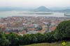
In the heart of the cliffs
![]() Difficulty-Moderate
Difficulty-Moderate
![]() 3:20 h.
3:20 h.
![]() 10.8 km.
10.8 km.
In the heart of the cliffs
![]() Difficulty-Moderate
Difficulty-Moderate
![]() 3:20 h.
3:20 h.
![]() 10.8 km.
10.8 km.
The sea and the land merge with history and nature in Mount Buciero, at whose feet lies Santoña, the gateway to the extensive and important marshes that, together with this small peninsula that houses forts and old coastal batteries, form the Natural Reserve of the Santoña and Noja Marshes. The Path of the Lighthouse of the Horse and the cliffs crosses this valuable enclave taking us to know some of the treasures that it hides. Abrupt cliffs and lush holm oaks join bits of the history of this seafaring land.

The route with only 10.8 km starts from Santoña, more specifically from the Fort of San Martín, at the end of the promenade. This old fort, built on the remains of the castle that was located here, gives us a first idea of the different values that this route is going to offer us and that we will be discovering along the route. From here begins a hard ascent dotted with spectacular panoramic views and bits of history, such as the Galbanes Batterys that surprise us as soon as we leave San Martín behind. Ancient quarries have left their scars in the mountain and surely the stones that were extracted from them would be found in the fortifications that are located here, fortifications such as the Fort of San Carlos to which we can deviate before entering the mountain. The route plunges us fully into the abrupt landscape of cliffs that we are almost unwittingly crossing. Vertical walls that fall into the sea, such as the imposing Peña del Fraile where prehistoric remains have been found. The holm oak forest, one of the most important in the Cantabrian Sea, rivals the enormous and vertiginous cliffs as we approach the impressive staircase that leads to the Lighthouse of the Horse.
")
At the top of the cliff, the San Felipe Battery offers us a privileged panoramic view of the lighthouse and its surroundings. Once we have recovered the breath of the notable effort of visiting the lighthouse, rewarded with more than enough for the landscape that surrounds us during all this stretch of the route, we continue crossing the thick holm oak grove. The cliffs do not separate from us and the forest we are walking through hides us and protects us from its verticality. The Fisherman's Lighthouse and its privileged location mark an important change in the landscape, a landscape that will take us to Dueso, but not before giving us the opportunity to descend to the Eagle Battery. The sandy area of Berria next to the old Fort of Dueso, today a penal one, welcomes us to this small district from which we will set a course back to Santoña bordering Mount Buciero. This greenish and demanding stretch takes us to pass next to the old powder magazines of Dueso and Helechal from where we can take a small detour that will take us to the nearby Napoleonic Fort of El Mazo. All that remains is a pleasant descent that will allow us to look out over the marshes from the Viewpoint of Casablanca, to quickly reach the San Martín Battery and shortly afterwards the San Martín Fort, where this spectacular route ends.

Legend has it that, in the past, when the numerous forts and batteries that protected this important coastal enclave were at full capacity, a large number of corsair boats emerged from the horizon with the clear intention of assaulting and looting these coasts. The corsairs, aware of the dread they instilled among the inhabitants of the coasts, cast anchors waiting for the best time for their attack, without knowing the firepower that was pointing at them. Seeing the opportunity that the trusting corsairs offered him, the commander in chief ordered to open fire against the enemy with all the batteries in unison. Such was the din and the intensity of the attack that the earth trembled to the point of breaking up an enormous block of the mountain precipitating towards the sea, giving rise to what today we know as the Fraile's Rock. The few corsair ships that barely resisted the attack fled in terror when they saw how even the earth came over them next to the cannonballs that were sinking them.
Santoña can be reached by following the CA-141 that runs along the entire coast that separates Santoña from Santander, communicating the town with Argoños, Noja or Pedreña among others. Also after crossing the marsh, the CA-241 from Cicero reaches Santoña, joining Santoña with the A-8 motorway between Bilbao and Santander and with the old N-634. Once there, we must head towards the promenade to cross it in the direction of the fortresses. Along the whole promenade we will have parking lots where we can leave our vehicle, also in the proximities of the Fort of San Martín, where the route begins, we will find an area fitted out as parking lots.
Without a doubt, our companion will also have to make a great effort to climb the stairs of the Lighthouse of the Horse, which can be added to the respect they can give you and to the rest of the route you will have to follow. It is important not to forget that we are in an area of cliffs so it is important to have it under control.
We can not miss its pertinent ration of water since we will not find points of water in all the route and the humidity also passes its pertinent invoice.
Surely we will find enough pets in the route and in the section of the lighthouse. Some braver and more daring, others, usually the smallest, save in the arms of their owners this ordeal.
We start the route next to the Fort of San Martín (0h 00min), at the end of the Santoña promenade, ascending the staircase that leads to the entrance door to the fort.

Regardless of which staircase we follow, of the two that the main staircase becomes, we will go out to the street that we must follow.

We continue the ascent bordering the enclosure of the fort while we follow the course of this road.

Quickly we leave behind the fort at the same time that to our left is the street where we will return.

At the moment we leave a steep cement track that if we follow it would take us to the road we have just left behind.

Without further ado, we will be obliged to decide whether to take a detour to visit the Fort of San Carlos or to continue along the route without getting to know it.

Back to our route, we continue with the tiring ascent that will take us definitively out of Santoña.

The track, already turned into a cobblestone path, continues to gain height as we leave behind old quarries. The height gained allows us to enjoy magnificent views of the coast that compensate for the effort we are making.

For now and with a few exceptions we are at the mercy of the sun without the slope giving us a break at the same time that we continue without major complications the marked way.

The cobbled path, in some sections, adds to the unevenness of the terrain making us somewhat uncomfortable advancing.

The Rock of the Friar forces us to take a breath to contemplate the beautiful place that surrounds us, before continuing with the ascent.

As soon as we pass by the House of the Firewood we leave a narrow path that enters the forest on our left, to face another hard ramp.

Luckily, the holm oak forest begins to gain protagonism protecting us in this part of the route. The road winds through the mountain making us gain height not without effort.

Some vertical cliffs mark the end of the ascent and the proximity of the detour that will take us to the lighthouse.

But before that there will be several trails that are introduced into the forest and that we will leave aside.

A cobbled junction of paths joins several of the paths that run through the mountain, including the one we must follow towards the lighthouse. As if it were a toboggan, a rapid descent and ascent brings us closer to a new fork in the road.

The trail on our right, if we follow it, would first take us to the San Felipe Battery, and then return on our steps to resume the path to the lighthouse.

A few metres ahead of this fork we will find the beginning of the vertiginous stairs that furrow the cliff.

This part of the route requires the necessary calm to descend, in some sections, the steep stairs down to the lighthouse.

Stairs in quite good condition and equipped with a towline as a recurring guardrail. The initial winding layout of the staircase carved in the rock descends quickly, without letting us even intuit the enclave towards which we are heading.

The upper part of the stairs, which is slightly more open, gives us an idea of what we have just been through.

Almost without warning, when the staircase seems to have no end other than the Cantabrian Sea, the Lighthouse of the Horse (1h 05min) appears before us.
Once you have enjoyed this privileged corner of the coast, it is time to climb up the cliff, facing the steep stairs down again.

Once upstairs and after visiting the San Felipe Battery, if we had not done so before, we returned to the crossroads where we left the path that brought us here.

Once there, those who so decide, continue on the right, leaving behind the path we took from Santoña and the path that ascends to the top of the mountain, cutting it in the middle.

Now we have a pleasant path waiting for us that goes through the forest allowing us to recover the strength lost in the stairs. The well marked path leaves little room for doubt as to the direction to follow.

Even so, there are several junctions to be found, trails that invite us to vary the route and climb to the top of the mountain.

Soon the relative comfort of the route will be cut from the roots when we find a steep area that saves a nearby cliff from which we only separate the trees.

This section, although not very difficult always under normal conditions, does require more attention to avoid unnecessary scares.

We go up the hillside following the steep path marked in some areas by a symbolic railing. Soon the slope softens and the terrain becomes somewhat more comfortable. We will quickly begin to descend again for now without major complications.

As in the previous ascent, the rope that acts as a handrail indicates that we have reached the steepest part of the descent.

The trail zigzags along the stark slope of the mountain, forcing us to take this section with a certain calm, especially if we have no experience in this type of terrain.

The rope, the marks and the footpath are in charge of marking the course to follow. After this entertaining area, the route returns to its usual good condition, allowing us to sense the proximity of the sea that has accompanied us at all times.

The forest gives way to the cliffs and the Lighthouse of the Fisherman (1h 55min) next to which we have to pass.
The path leads directly to the access road to the lighthouse, road which we must continue along.

This road will be in charge of taking us without further complications to the very doors of this neighborhood of Santoña.

Again we will see ourselves striving to advance by gaining height with each step we take.

After a while we will find the path that, if we follow it, goes down to the Battery of the Eagle. Our route continues along the course of the road until we get close to Dueso.

The walls of the prison will serve as a reference for us to follow as we bid farewell to the road that brought us here.

We cross the wall until its end, when we will face a new hard ramp between the houses of Dueso.

Suddenly the route turns again undertaking another descent that will finally enter us in Dueso (2h 30min).
In front there is a short descent in which we will leave aside a first cement track.

A little further down begins the clue that we must continue to leave behind Dueso. This track that takes us to pass by the Dueso Magazine undertakes a hard ascent, even more demanding at this point of the route.

We continue to gain altitude, leaving behind the paths we are encountering. The cement track serves as an improvised guide in this part of the route.

The landscape, which had already changed before, changes again, giving us now the greenery of the meadows. The hard ramps that we are ascending barely give us a small breath that allows us to recover our breath.

Not effortlessly do we climb to the top of the hill that stands in our way. The Helechal Powder Magazine marks the point and end of the ascent and the beginning of the last stretch of the route.

Once at the top of the hill, leave behind us the track that ascends to the Fort of Mazo, to head towards Santoña.

There are several alternatives that are proposed to us in this area, a trail that descends to the town, another that ascends the mountain.

We will follow the track that begins at this point the fast descent in search of the end of the route.

This track takes us without further ado to the fort where we started the route. But before that, it is the San Martín Battery that leaves on our way.

Here we have several possibilities, to take some stairs to our right, that later pass under the road that we are following.

Follow a steep cement track that descends quickly to the road where we started the route.

Or follow the meandering course of the road that leads here and continues down among the first houses of Santoña. In this case we will find ourselves a little lower with those who followed the stairs.

In the other case we will have to follow the road by which we began the route until we meet again with the other two options.

Already together we only have to retrace what we walked at the beginning of the day for, bordering the Fort of San Martín (3h 20min), descend the stairs that will take us to the promenade of Santoña, point of beginning and end of this route.
 Distance. 10.8Km
We can return from the lighthouse by the same route, thus shortening the route considerably.
 Time. 3:20h
The many trails and variants that we can follow make them change a lot the time we need to make the route we choose, also we will have to add to the good insurance a lot of time we dedicate to the visit to the Lighthouse of the Horse.
 Time of year
The fog and rain, in addition to dampening the magnificent environment surrounding this route and the places through which it passes, increase the difficulty of the route, making it even unwise to descend to the lighthouse. For the rest we are in front of some spectacular places that will do the delights of who visits them.
 Required equipment
Appropriate footwear for hiking should, under normal conditions, be more than sufficient and the minimum to wear. It is important to bring some water since we will not have fountains and although the sun does not squeeze the humidity and the effort that the stairs demand of us can play a trick on us. Protection against the sun, the camera and lunch can also be good companions of adventure. Consult our list of material and equipment for hiking. Read more.
 Difficulty. Medium
Physical
The distance is not where we will find the greatest physical difficulty of this hiking route of Cantabria, are the short but intense ramps that require us to be in good shape. To all this we must add the stretch of steps, very demanding both in the descent and in the ascent and that will force us to take this area calmly to be able to overcome it without suffering more than the account.
Severity of the environment
The route passes close to the vertical cliffs of Mount Buciero, although as long as we do not leave the marked route or follow another of the possible routes, the vegetation and the course of the path will keep us far enough away from them. Special attention must be paid to two areas of the route, the stairs of the Lighthouse of the Horse and the short but steep stretch of path that descends towards the Lighthouse of the Fisherman, being in these sections where we are most exposed to falls or detachments.
Orientation
Generally well signposted will be the different marked trails with which we will coincide, which may make us doubt at some point. In some of the crossings the posts that mark the route are not very clear with the path to follow if we are making the journey in the opposite direction described. For the rest the marks and the well marked layout should guide us without too many complications.
 |
 |
 |
 |
 |
| 1-Fort of San Martín | 0:00h | 6m | 0Km | 30T 463769 4809744 |
| 2-Lighthouse of the Horse | 1:05h | 15m | 3.3Km | 30T 465563 4811042 |
| 3-Lighthouse of the Fisherman | 1:55h | 40m | 5.6Km | 30T 464737 4812427 |
| 4-Dueso | 2:30h | 45m | 8Km | 30T 463209 4811697 |
| 5-Fort of San Martín | 3:20h | 6m | 10.8Km | 30T 463769 4809744 |
Coordenadas UTM Datum WGS84

 Slope: 1140m
 Slope +: 570m
 Slope -: 570m
 Maximum altitude: 240m
 Minimum altitude: 15m

This sketch of the route is not made to scale nor does it contain all the information relating to the area, it is merely indicative.

![]()
This schematic with the path is approximate and has been created from the derived cartographic base © Instituto Geográfico Nacional "Cuadrante 036-1, 1:25.000"
Senditur has manipulated the tracks to correct the aberrant points that may exist, caused by problems with the reception of the GPS signal. In any case the tracks are always approximate. SENDITUR encourages you to use the new technologies within your reach, using them as support and consultation in your activity, not basing the realization and orientation of the same only and exclusively on them, since they may see their functioning altered by very diverse causes, not functioning correctly and their indications may not be precise.


Me ha gustado mucho el Faro del Caballo, es un sitio que merece la pena visitar. La ruta también está muy chula. Muy recomendable!!!

El Faro del Caballo, simplemente una maravilla, las escaleras impresionan bastante y no te digo nada el esfuerzo de subirlas pero sin lugar a dudas merece la pena.

Una maravilla, lo recomiendo... merece la pena conocerlo

El primer tramo de escaleras impresiona bastante, hasta mi perro no quería bajar. Pero merece la pena es muy bonito.


Considered to be the best developed dune complex on the Cantabrian coastline.

Find out what to see in...
¿Did you know that...
Mount Buciero, through which the entire route passes, is a small peninsula that is included in the Nature Reserve of the Santoña and Noja Marshes, considered to be the most important set of wetlands in northern Spain.
Don't miss out...
The Observatory Of Birds Of The Arenilla, that you will find in the road of access to Santoña that arrives from Cicero. It is home to a large population of birds of various species that use these marshes as their main refuge both in their migration and to spend the winter.


From the commitment of SENDITUR with Nature and the respect to the balance of the environment, SENDITUR urges you to travel in a responsible way, with low environmental impact and respecting at all times the Natural, Cultural and Social environment wherever you go.

Besides sharing with all of us your experience on the route we would be grateful if you could write to us to inform us of any erroneous or outdated information you may have found, or simply to let us know what you think at Thank you.
This route has been carried out in the field by SENDITUR on 18-07-2018. The route may vary greatly depending on the time of year, weather conditions and terrain, as well as the actions of third parties and the evolution suffered in the natural environment where it is located. All opinions, advice and/or assessments made by SENDITUR in their descriptions are for guidance only and are subject to and/or refer to the specific conditions of the specific day of the route, referring to that specific day, taken from trained people, with the appropriate experience and with a high level of physical and technical preparation as a reference, as well as correctly equipped.
All the times are approximate and take an orientative character, the stops have not been taken into account, no matter how small they are. All the information related to the route, texts, images, videos, maps, diagrams, tracks, towns, and places of tourist interest are published as a guide, and may not coincide with the current state of each place. Before undertaking any activity, assess your technical knowledge, your physical condition, find out about the weather and the variations that the route may undergo, equip yourself correctly, be prudent and responsible at all times, and do not exceed your capabilities. SENDITUR is not responsible for any misuse or inappropriate use of the comprehensive guides of its routes and/or publications as well as its electronic guides, nor for any variations in their descriptions for the aforementioned reasons, and recommends that everyone be responsible and prudent in carrying out the activity. We also encourage you to read books and specialised guides to complement the information described above.
Continue watching …


.jpg "Go to Monastery Santo Toribio of Liébana")