Welcome to SENDITUR.COM · paths · routes · tourism


![]() Difficulty-Medium
Difficulty-Medium
![]() 1:40 h.
1:40 h.
![]() 4 km.
4 km.
![]() Difficulty-Medium
Difficulty-Medium
![]() 1:40 h.
1:40 h.
![]() 4 km.
4 km.
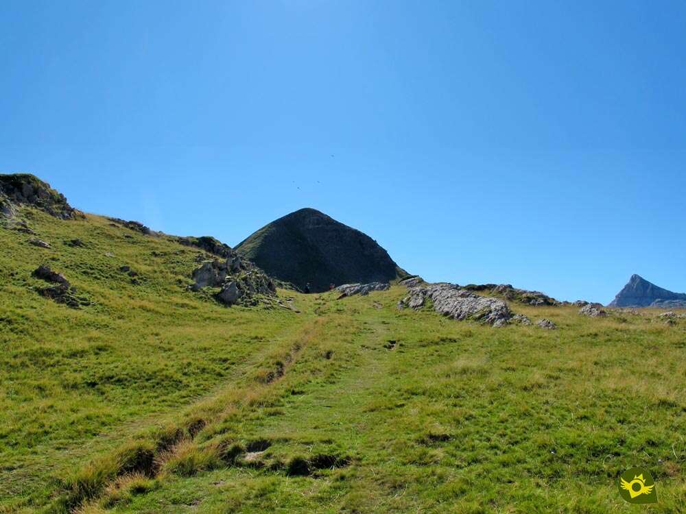
The Navarrese Pyrenees treasure privileged corners of great scenic and natural value, thick forests, deep valleys or karstic spots that could well seem taken from another planet. The ascent of the peak Arlas, in the upper part of the Roncal Valley, allows us to immerse ourselves in the Pyrenean environment without demanding big crossings or significant unevenness, giving us the opportunity to get a privileged panoramic view of other summits with more name or of greater importance.

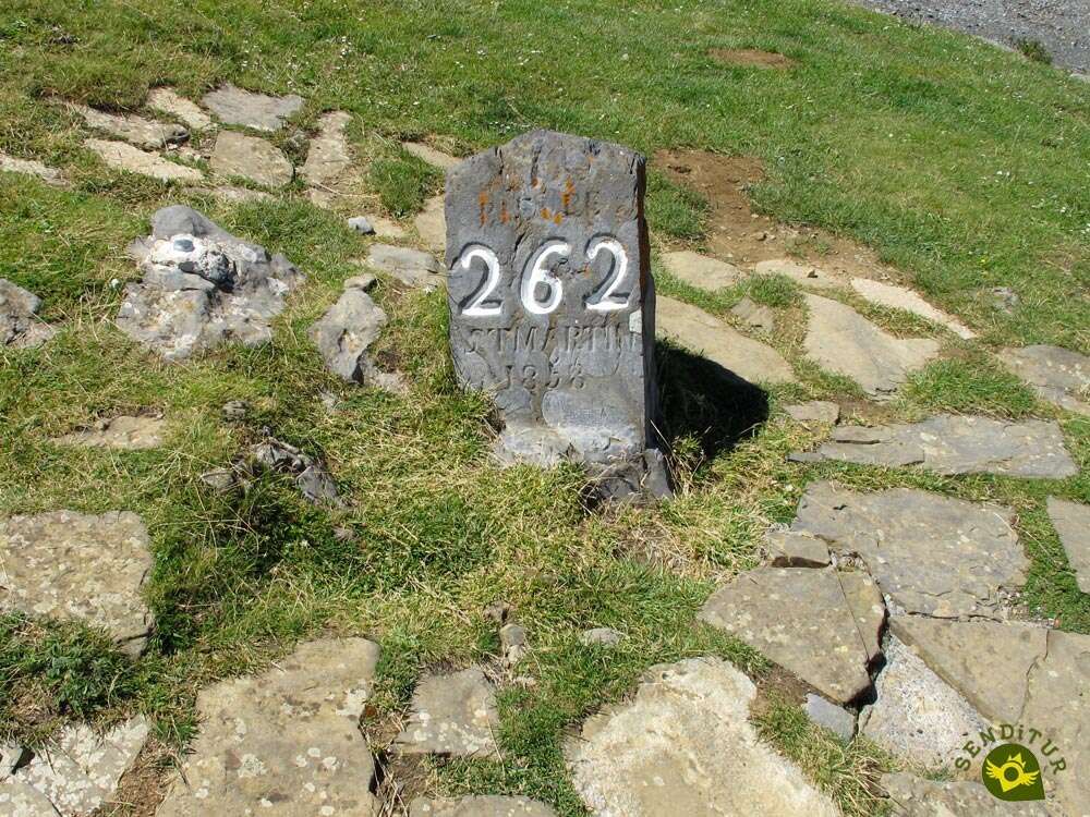
The ascent, with its 4 Km, starts from the same Stone of St. Martin, in the Ernaz pass, the 262 of the about 1300 stones that were placed in its day to mark the border between Spain and France. The route transports us in a first term through green meadows and steep slopes where the cattle graze, where it is taking form the raw material with which the famous cheeses of this land are made, so well-known and appreciated. The course of the route takes us to jump, without realizing it, from Spain to France and vice versa, change that only the landscape is responsible for showing us. On the one hand the French plains, on the other the karstic zone of Larra that shows us clearly its marked forms. The Col de l'Arlas, which we reach after leaving the trail that will return and that cuts the mountain by its slope, is a good balcony where you can contemplate the spectacular landscape that surrounds us, full of contrasts. From this point a short but demanding ascent awaits us under the protection of the French slope through which it runs. Section that requires all our attention, so we look for the excuse of recovering our breath to stop to contemplate the beautiful panoramic that is had along the ascent.

The summit of the peak Arlas gives us a deservedly unbeatable view of the Karstic complex of Larra, full of colossal chasms and impressive appearance. From here, the perfect silhouette of the Auñamendi or Pic d'Anie Peak, which overlooks the rest of the remarkable peaks that can be seen from the Arlas, is even more striking. This mountain surprises in spite of its modest height, in comparison with others of the Pyrenees, and it catches us with its charms making us lose the notion of time. The descent is offered with several alternatives, more something invites us to know the other slope of the mountain and descend the southern edge to the col of Pescamou, point of union of several routes. From there, those who do not have major objectives, simply have to return by the path that from the Arlas pass we saw as it walked the foothills of the mountain. This trail brings us back to the trail followed by those who decided to return along the same route they used to reach the Arlas, but not before allowing us to contemplate the wide valley that extends on the west side of the mountain. After passing by the La Contienda fountain and under the Arlas col, both paths come together again to take us together to the Ernaz col, and conclude the ascent.

According to legend, many years ago, when Arab troops invaded the entire valley area to cross the Pyrenees and occupy French lands, the inhabitants of the French area, fearful of the atrocities that the invading troops were making on their way, decided to entrust themselves to the patron saint of France, Saint Martin, and placed along the border a series of stones dedicated to this saint to rid them of the Muslim invasion. This seems to have been successful, at least in part, as the Arab army was defeated and its invasion stopped.
To reach the Ernaz pass or the San Martín stone pass, head towards Isaba, either from Ezcároz and Ochagavía along the NA-140 road that leads to Isaba from the N-135 shortly before reaching Roncesvalles. Or from Sigües on the A-21 between Pamplona and Jaca going up the Roncal Valley on the NA-137 through Burgui, Roncal and Urzainqui. Once in Isaba, continue up the river following the NA-137 in the direction of France. Without leaving this road at any moment we will be ascending leaving behind zones of parking and facilities of ski slopes until arriving at the hill, which we will be able to recognize by the esplanade to the flush of the road that does the times of parking, where we will be able to leave our vehicle.
Ideal ascent to begin in the mountain with our dog and that this one becomes accustomed to less kind lands. It is not too much to take him some boots that protect him from cuts or abrasions the legs. Be careful, we are in an area where the holes and chasms are more numerous than we might think, so it is not advisable to lose sight of him.
Without points of water and as on the other hand always we should do, we will have to bring him the water and the necessary food for this type of routes by mountain.
The cattle is the owner and lord of this zone, camping to his desires by any place, it is not rare that cows, sheep and goats are accompanied by some that another shepherd dog, that surely will approach to greet.
The parking area of the Ernaz col (0h 00min) is the starting point for this ascent of the Arlas peak.

We follow a short path that leads us to pass by the shelter that dominates this hill of magnificent views.

As soon as we pass him, to our left begins the trail by which we must continue. This first section of the route is a rise and fall with the silhouette of the Arlas watching us.

The layout of the path is quite clear although sometimes the grass dilutes it under its mantle. The peak to which we are heading is shown nearby, serving as a reference to follow.

We follow the undulating trail that alternates somewhat steep areas with green and soft stretches. We advance following at all times the course of our trail and the solitary milestones that mark the route.

A small lagoon for livestock marks the point at which we will undertake a new ascent zone, somewhat more demanding than the previous ones.

Here we will have to be attentive since there are several trails and paths that ascend the hillside forcing us to look for the best option. The path makes us gain height saving the rocks that populate this hillside.

A new stone milestone marks the end of this uncomfortable stretch taking us to the green meadows through which we will pass.

The slope continues without giving us a break, forcing us to advance calmly. After a short while, our trail comes up against what might well seem like an old way to continue ascending.

The slope seems to give us a break soon, allowing us to contemplate the magnificent landscape that surrounds us.

The route now runs halfway up the slope with our sights set on our target. Once again we will come across different trails that run in parallel joining later.

From here we can intuit the ascent that awaits us, at the same time that we see the layout of the trail that cuts the mountain and through which we will return.

Without realizing it we arrive at the bifurcation (0h 35min), where we have to decide the way to follow to confront the top by its north slope or to continue straight until the col of Pescamou and to ascend by the south.
Quickly we see ourselves in the ample col of the Arlas contemplating the French slope that until the moment we had hidden.

After enjoying the landscape at the same time that we recover the forces we head to confront the true ascent to the Arlas.

In front of us we can sense the first sinuous stretch of trail that begins to ascend the slope of the mountain. A cobbled trail that after a couple of changes of orientation begins to lose part of the steep slope it was raising.

Soon we see ourselves advancing by cutting the steep slope of the mountain as we continue to gain height with each step.

The decomposed trail takes us directly to the north shoulder of the mountain where we will face the final stretch of the ascent.

When we reach a lonely milestone we will come across another trail that comes here from the French side, marked by a typical wooden pole. This is the moment when our route changes its orientation abruptly, taking us to the summit we wish to conquer.

In front of us there is a hard but short ramp that we must take with calm and caution. There are several routes that have been formed for the ascent and that can facilitate or entangle the route.

It is important not to lose the correct layout that with its small zetas ascends almost in line towards the top.

After the effort made, before us when we reach the summit of Pico Arlas (1h 00min), opens a spectacular landscape that more than rewards the work done.
Without a doubt, this summit will absorb us for a while contemplating the landscape before starting the descent.

We have a couple of possibilities, either to return directly by the same route or to extend the route descending by the slope that those who from here want to accede to the Pic d'Anie follow.

As soon as we look out over the southern ridge we can contemplate the long descent that awaits us up to the hill. The slope is also important but not as important as the other side of the mountain.

In return we will have a somewhat steeper terrain but initially less decomposed and easier to follow than the other. We lose height quickly, while trying to avoid deviating to the sides of the mountain where we will be more exposed.

After saving the chaos of stones in the first part of the descent we only have one last stretch with less inclination in which the trail tends to disappear covered by green grass.

Without realizing it, we will see ourselves in the middle of the Pescamou col (1h 15min) where several paths converge.
We changed our orientation radically, leaving behind the path that leads to the Pic d'Anie.

We began to walk along the trail that time after time we saw as it cut the hillside of Arlas Peak. This part of the route with hardly any unevenness runs along a sometimes decomposed trail that will take us back to the surroundings of the Arlas col.

Without great complications we are progressing observed by the top we just crowned.

The valley precipitates to our left at the same time that we can already see the course of the trail towards which we are heading.

Shortly before arriving at the point where both routes join again, we pass by the Fuente de La Contienda, a small spring with no assured flow.

The Arlas Col is above our heads just before reaching the bifurcation (1h 25min) where we had previously headed towards the north face of the Arlas.
From here we will see each other travelling, but in the opposite direction, the same trail that guided us at the beginning of the route.

We will have to be careful not to miss the few detours that we have to find, even if they end up taking us to the same point.

Again after the descent we will be touched by the uncomfortable area of ascents and descents that precedes the parking lot of the Ernaz col (1h 40min) where we end this ascent.
 Distance. 4Km
Descending one slope or the other does not change this figure significantly.
 Time. 1:40h
Indistinctly we return by where we ascended or we descend by the opposite slope to border the top in search of the way back, we will use a similar time in both cases, being of course something minor if we return direct by the north face instead of by the south.
 Time of year
In summer conditions in which snow or ice are not present, we are faced with an ascent that allows us to make contact with the Pyrenean environment and enjoy, on clear days, the magnificent panoramic views that can be contemplated from the top of the Arlas. Winter is a real spectacle reserved for people with the equipment and experience necessary for this type of terrain.
 Required equipment
Fog and abrupt weather changes are more common than we might think, so we have to count on it when it comes to our equipment. We cannot let ourselves be deceived by the apparent simplicity of the ascent and forget that we are on a mountain terrain. Water, some food, canes, clothes that protect us from the rain and wind, and provide us with some heat, along with the necessary information about the route and the area. As always, a small first-aid kit with all the essentials cannot be missing from our backpack. As for the footwear, high trekking boots that provide stability and grip is a good choice, especially if we do not have the necessary experience. Consult our list of material and equipment for hiking. Read more.
 Difficulty. Medium
Physical
Both the distance and the slope are quite acceptable in comparison with other ascents of the Pyrenees, making this mountain chosen by many people who want to have a first contact with the sensations and the Pyrenean landscape. Even so, we will have to face the short but intense ramps that give way to the summit, whose slope is considerable. Facing the ascent with enough time to allow us to advance calmly and not breaking uselessly in the section that leads to the Arlas pass, before the beginning of the real ascent, the route is accessible to little that we are accustomed to walk.
Severity of the environment
A large part of the ascent passes through marked trails on the middle of the slope, which in normal conditions should not be a problem, provided that we do not explore other routes or that snow, ice or mud do not make an appearance, in which case the subject becomes quite complicated, increasing the level of difficulty. Point and apart are the sections from the hills to the top and vice versa, here we are before a terrain that combines steep and abrupt areas, without great difficulties, with cobblestone paths that cut steep slopes, a terrain that can come to impress at least accustomed but with the necessary prudence and calm do not cover remarkable complication, but in which we will be more exposed than it seems.
Orientation
With good visibility and terrain conditions, the footpath and the typical stone milestones next to some other brand guide us without major complications, but we must be aware that there are several trails that cross this area and we can easily skip a mark. We will find several points where it is easy to get lost, as for example in the surroundings of both hills and on our return, to undertake the descent of a green meadow where a lonely landmark marks the point where the detour is.
 |
 |
 |
 |
 |
| 1-Col of Ernaz | 0:00h | 1765m | 0Km | 30T 682044 4759790 |
| 2-Bifurcation | 0:35h | 1907m | 1.2Km | 30T 683050 4759694 |
| 3-Arlas Peak | 1:00h | 2043m | 1.8Km | 30T 683366 4759625 |
| 4-Col of Pescamou | 1:15h | 1919m | 2.2Km | 30T 683474 4759263 |
| 5-Bifurcation | 1:25h | 1907m | 2.8Km | 30T 683050 4759694 |
| 6-Col of Ernaz | 1:40h | 1765m | 4Km | 30T 682044 4759790 |
Coordinates UTM Datum WGS84

 Slope: 646m
 Slope +: 323m
 Slope -: 323m
 Maximum altitude: 2043m
 Minimum altitude: 1765m

This sketch of the route is not made to scale nor does it contain all the information relating to the area, it is merely indicative.

![]()
This schematic with the path is approximate and has been created from the derived cartographic base © Instituto Geográfico Nacional "Cuadrante 118-1 1:25.000"
Senditur has manipulated the tracks to correct the aberrant points that may exist, caused by problems with the reception of the GPS signal. In any case the tracks are always approximate. SENDITUR encourages you to use the new technologies within your reach, using them as support and consultation in your activity, not basing the realization and orientation of the same only and exclusively on them, since they may see their functioning altered by very diverse causes, not functioning correctly and their indications may not be precise.


Pilgrimage destination in honour of the patron saint of Navarre, Saint Francis Xavier

¿Did you know that...
Every year on July 13 they gather around the Stone of San Martín, border between the territories of Roncal and Baretous, inhabitants of both zones to carry out the ancestral Tribute of the Three Cows, by which the Bearneses deliver three cows to later place their hands on the Stone of San Martín and exclaim three times the phrase Pax Avant (peace from now on) thus giving for renewed an agreement of more than 600 years by which pastures and sources are shared by both communities.
Don't miss out...
The Day of the Roncalesa Clothing that is celebrated every year the first weekend of August, in that day it is possible to see each one of the known suits that have come to exist in the Valley of the Roncal. Single men without commitment, single women without commitment, newlyweds or shepherds, are some of those who wear Isaba neighbors each year dedicating the day to a specific part of the history of the region.


From the commitment of SENDITUR with Nature and the respect to the balance of the environment, SENDITUR urges you to travel in a responsible way, with low environmental impact and respecting at all times the Natural, Cultural and Social environment wherever you go.

Besides sharing with all of us your experience on the route we would be grateful if you could write to us to inform us of any erroneous or outdated information you may have found, or simply to let us know what you think at Thank you.
This route has been carried out in the field by SENDITUR on 17-08-2019. The route may vary greatly depending on the time of year, weather conditions and terrain, as well as the actions of third parties and the evolution suffered in the natural environment where it is located. All opinions, advice and/or assessments made by SENDITUR in their descriptions are for guidance only and are subject to and/or refer to the specific conditions of the specific day of the route, referring to that specific day, taken from trained people, with the appropriate experience and with a high level of physical and technical preparation as a reference, as well as correctly equipped.
All the times are approximate and take an orientative character, the stops have not been taken into account, no matter how small they are. All the information related to the route, texts, images, videos, maps, diagrams, tracks, towns, and places of tourist interest are published as a guide, and may not coincide with the current state of each place. Before undertaking any activity, assess your technical knowledge, your physical condition, find out about the weather and the variations that the route may undergo, equip yourself correctly, be prudent and responsible at all times, and do not exceed your capabilities. SENDITUR is not responsible for any misuse or inappropriate use of the comprehensive guides of its routes and/or publications as well as its electronic guides, nor for any variations in their descriptions for the aforementioned reasons, and recommends that everyone be responsible and prudent in carrying out the activity. We also encourage you to read books and specialised guides to complement the information described above.
Continue watching …


