Welcome to SENDITUR.COM · paths · routes · tourism


Way of Zemeto
The antechamber of the karstic complex of Larra
![]() Difficulty-Medium
Difficulty-Medium
![]() 1:25 h.
1:25 h.
![]() 4.8 km.
4.8 km.
The antechamber of the karstic complex of Larra
![]() Difficulty-Medium
Difficulty-Medium
![]() 1:25 h.
1:25 h.
![]() 4.8 km.
4.8 km.
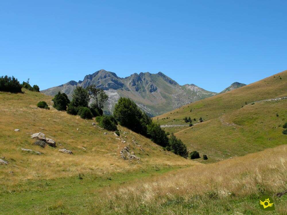
The Pyrenees, and in this case Navarre, are full of old paths used for years by locals, smugglers and shepherds, to give life and in many cases to unite the towns and places of this land. These paths usually cross beautiful landscapes, spectacular places and rugged mountains, becoming in many cases part of the history and culture of the lands they tread. The Way of Zemeto in the Roncal Valley and Belagua leads us through narrow corridors, wide Pyrenean meadows and breathtaking panoramic views once reserved for a few.

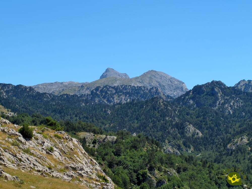
The 4.8 km route begins next to the once imposing Belagua Refuge, whose unbeatable location at the foot of Navarre's high mountain has not served to maintain its activity. The route transports us through the green Pyrenean plains of the upper part of the Belagua valley, bringing us closer to spectacular landscapes formed by nature. We descend to the plain of Eskilzarra from where we will be able to contemplate the curious formations of the karstic complex of Larra with the majestic summits of this zone of the Pyrenees observing us from the top. The Zemeto Pass is the natural border between the plains that precede the great mountains and the vertical walls that separate us from the fertile Belagua valley. The route allows us to enjoy the lush forests whose trees, some of them centennial, take over the slopes and walls that the cattle industry has left unused. We walk on a real balcony with unbeatable views, such as those offered to the valley by the hidden viewpoint to which we can deviate.

Gentle meadows swept by the wind alternate with the exuberant vegetation of the beech forest that the route takes us through. An assortment of landscapes and sensations concentrated in such a short distance that makes us think if it is true that it is only those kilometers. The old military barracks of Yeguaceros, another example of the inexplicable actions that man's hand has in many cases in nature, brings us back to the real world. Next to it, the Belagua Viewpoint awaits us another essential stop, whether we arrive at it on foot or along the road that passes by it. Here we will be able to contemplate calmly this glacial valley in which is the forest of La Mata de Haya, another reference of the Navarrese Pyrenees. From this vertiginous place we embark in going up again the lost height up to the refuge that waits for our arrival. In front we have another pleasant walk following an old path of shepherds that crosses the green foothills of the mountain. The Refuge of Belagua surprises us without warning marking us the point and end to this route and surely leaving us with desire to know more landscapes and hidden corners.

Those who decide to do so, either because they have less time or because they don't want to go into the part of the route that has more difficulty in orientation and physics, have the possibility to return to the Refugio de Belagua from the lookout. All they have to do is go back through the pass of Zemeto, following the same itinerary by which they arrived to it, leaving the route in 3 Km and lowering the difficulty even more.
To get to Belagua Refuge we have to go towards Isaba, either from Ezcároz and Ochagavía via the NA-140 road that goes to Isaba from the N-135 shortly before reaching Roncesvalles. Or from Sigües on the A-21 between Pamplona and Jaca going up the Roncal Valley on the NA-137 through Burgui, Roncal and Urzainqui. Once in Isaba, continue up the river following the NA-137 in the direction of France. Without leaving this road at any time we will go up the cliff that fits the valley of Belagua, for shortly after passing through the abandoned military barracks we come across the track that descends to the nearby Refugio de Belagua, where we have a wide esplanade to park our vehicle.
Quiet and pleasant walk in which you can enjoy the stimuli that are found along the way, attention especially in the area of the road.
We will not have water points along the route, unless it is the time when the streams have some flow of thaw or rain, even so it is better not to trust and have their corresponding ration.
The cattle are the owner and lord of these places, with the permission of the bear that inhabits these forests and mountains but that in all probability we will not even pass near him. After a day of hiking or mountain with our dog is not too, especially if we are in areas where he has usually won, let's take a look if a parasite has found a more comfortable home than he had.
The battered shelter of Belagua (0h 00min) kicks off this entertaining hiking route.

A solitary poster with the information of the route serves as a reference to start walking.

We descend to enter the green prairie that awaits us, encountering the post that indicates the place where the circle we are going to make is closed and the direction we must follow.

The red and blue signs of our route mix with the red and white signs of the GR with which we will coincide for now.

With our eyes set on the colossal mountains of the horizon, we continue descending, losing height calmly while we follow an almost non-existent trail.

What could well be an old way, today covered by pastures, describes a long curve as our route shortens its layout to bring us back down to it.

The itinerary borders a small hill to take us to the well-known Pass of Zemeto (0h 15min).

We are about to cross this narrow gorge that breaks radically with the landscape we had walked up to now.

We follow the cobbled trail embedded between the vertical walls that flank it, a trail that struggles with the vegetation that populates this shady pass.

As soon as we leave the corridor we come across a crossroads where we will have to say goodbye to the GR company that descends towards the valley floor.

We follow a marked trail, without the typical X that marks the wrong path makes us doubt our good direction. We advance gaining little by little height protected by the shade that the trees give us.

Soon this shadow disappears and we go out again to a clearing where the post that marks the detour to the lookout awaits us (0h 25min).

A trail of just 200 m that brings us to a magnificent balcony that is worth approaching.

We approach it leaving to our left the other trail that, like the GR, also goes down to the valley. A footpath takes us, after making us gain some height, to the lookout (0h 30min).
After dedicating the necessary time to the panoramic views that this viewpoint offers, we return to the point where we take a detour.

Once in it, we returned to the path we had parked for a moment. We are waiting to go up a gentle hill on which our trail is no longer so steeped and the marks are somewhat more complicated to see, partly due to the vegetation.

Even so, we did not find any other trails that might make us doubt the course to follow and we continued to save the rocks, which we found in our way of branches and vegetation.

The slope makes us gain height with each step, asking for a greater effort than the route so far had asked us.

Almost without warning we see ourselves in a kind of small hill from which we can see the building of the military barracks towards which we seem to be heading.

Now another downhill section awaits us that takes us to a more wooded area without changing the course that brought us here.

The landscape changes again and we see ourselves walking through the interior of a leafy beech forest. Here our trail becomes more visible again, making it easier for us to follow the right route.

This sombre part of the route runs through the forest saving small streams, usually dry.

Once again we see ourselves striving to gain height, also sensing the near end of the forest that protects us.

As we already predicted, our forest gives way to another green meadow, through which the route continues. For some time now, the marks of the route are not so evident, although for now they continue to guide us while the pastures take over the trail again.

We reach the point where the trail and the marks disappear, where we have to decide whether to continue without deviating to the barracks or turn almost round to cross the meadow following an apparent trail that ascends towards the road.

This option, in theory the official one, lacks more marks until arriving at the top and forces us to a greater effort due to the slope that saves.

A large part of the route will have to intuit the route to follow as the pastures cover the entire terrain, we will also find a small area somewhat steep that should not put us in great trouble.

Even so, it can be intuited that there are several hikers who opt for this route to join the trail that runs under the road.

If, as it surely happens, we skip this hypothetical crossing and go on, we will face a small meadow marked on both sides by vegetation.

We ascend through this area without any trail or mark to ensure the correctness of our choice, until a little further ahead in front of us seems to take shape a footpath while sensing a typical post that marks the routes.

Effectively we find ourselves with a solitary mark of the route that we are doing that desdice the plane of the informative poster of the beginning of the route.

We advance halfway up the slope, gaining height calmly, getting closer and closer to the abandoned military barracks building.

The pastures cover again the trail that guided us and only the barracks, as long as the fog does not impede it, serves us as a reference to guide our march.

After looking for the best way to skirt some drains of the torrents that fall into the valley, we left for the road that leads to the refuge.

A few meters ahead, the unbeatable viewpoint of Belagua awaits us (1h 00min).
Taking advantage of this corner of the Navarrese Pyrenees as it should be, we set out again.

The road will serve us as an improvised reference time, being able to initially follow its course or that of one of the trails that the cattle have formed next to it.

In any case, soon after the guardrail marks the time to say goodbye to the nearby asphalt company.

From this point an increasingly steep trail leads us cutting the slope of the mountain, far enough away from the road but following the line it draws.

At the moment we meet again with the posts of the route that abalan us the good march that we take.

The pastures put our path in trouble again, while it follows the undulating mantle of the mountain.

We passed without noticing the point where the two options that had previously been proposed to us come together to continue the march towards the refuge.

We still have a pleasant walk through a more gentle and treaded terrain but it still makes us strive to recover the height that separates us from our goal.

There are several streams, dry in summer, that we are crossing while we follow the course that the marks and the wide trail indicate us.

The slope continues to be evident and little by little the mountains that at the beginning had enlivened the route come back before us.

Without too many possibilities of wandering in the itinerary to follow, the tread of the land can serve us as a reference in case of doubt.

Almost without warning, we are surprised by the unmistakable silhouette of the shelter to which we are heading. We arrive at the point where some time ago we had begun this circular route, from which we only have to save the small difference in level that separates us from the Belagua shelter (1h 25min), to finish this hiking route in the Roncal Valley of Navarre.
 Distance. 4.8Km
Not visiting the viewpoints saves some distance.
 Time. 1:25h
If we pay attention to the map of the informative poster of the beginning of the route and we shorten the layout proposed in this description, it supposes to enter us through the apparent path that crosses the green fields of the mountain. If we do it we will only subtract about 800 m from the total distance. If we add to the greater slope that we will have to face, we will not save as much time as we could think.
 Time of year
Although it is an affordable route almost all year round, and even with enough snow can be a good walk with snowshoes, to tell that part of its attractions are the panoramic views that we can enjoy the Belagua valley and the mountains of the Pyrenees is advisable that the fog is not the protagonist as well as not letting us contemplate the landscape can put us in many difficulties to follow the final stretch of the route.
 Required equipment
Some nettles, thick vegetation in some areas and stretches through pastures where cattle graze can cause leg problems if we take them to the air. For the rest we cannot lack the water and some food since we will not have fountains along the route. Walking sticks and boots are also not a bad idea, as well as carrying the necessary information of the route and the environment to be able to consult if necessary. Consult our list of material and equipment for hiking. Read more.
 Difficulty. Medium
Physical
Physically it is not a route that because of distance and unevenness requires us to have a great preparation, although we do have to face in the final part of the itinerary with some other ramp of entity, especially if we shorten the journey.
Severity of the environment
We will largely pass through green pastures that under normal conditions should not cause us any problems. The sections in which we will have to be more attentive coincide with the Pass of Zemeto, in which the trail is somewhat decomposed, and the part that runs through the interior of the beech forest, where if the mud makes an act of presence it will be quite slippery. If we approach the viewpoints we must not forget that although it does not seem to fall vertically is quite important. Pay attention to the short stretch of road to go to the viewpoint, there is more traffic than we think.
Orientation
Perhaps this is the point that increases the difficulty rating of this route. Although it is largely signposted and there are informative posters at the beginning of the route with the layout, there comes a point, when we try to close the circle of the itinerary, that the marks and signs disappear, perhaps covered by pastures and vegetation. In addition we will coincide with several routes that add their marks to ours. The vegetation and pastures do not make it easy to follow the route either, as it tends to blur the path and even make it disappear, coinciding with the absence of marks and signs. The abandoned road or barracks are two references that can help us to recover the path and lost marks.
 |
 |
 |
 |
 |
| 1-Belagua Shelter | 0:00h | 1424m | 0Km | 30T 676629 4756980 |
| 2-Zemeto Pass | 0:15h | 1345m | 0.9Km | 30T 677082 4756592 |
| 3-Detour to the lookout | 0:25h | 1343m | 1.3Km | 30T 676755 4756529 |
| 4-Lookout | 0:30h | 1357m | 1.5Km | 30T 676679 4756343 |
| 5-Detour to the lookout | 0:35h | 1343m | 1.7Km | 30T 676755 4756529 |
| 6-Belagua Viewpoint | 1:00h | 1341m | 3.3Km | 30T 675434 4756629 |
| 7-Belagua Shelter | 1:25h | 1424m | 4.8Km | 30T 676629 4756980 |
Coordinates UTM Datum WGS84

 Slope: 414m
 Slope +: 207m
 Slope -: 207m
 Maximum altitude: 1424m
 Minimum altitude: 1290m

This sketch of the route is not made to scale nor does it contain all the information relating to the area, it is merely indicative.

![]()
This schematic with the path is approximate and has been created from the derived cartographic base © Instituto Geográfico Nacional "Cuadrante 118-1 1:25.000"
Senditur has manipulated the tracks to correct the aberrant points that may exist, caused by problems with the reception of the GPS signal. In any case the tracks are always approximate. SENDITUR encourages you to use the new technologies within your reach, using them as support and consultation in your activity, not basing the realization and orientation of the same only and exclusively on them, since they may see their functioning altered by very diverse causes, not functioning correctly and their indications may not be precise.


Pilgrimage destination in honour of the patron saint of Navarre, Saint Francis Xavier

¿Did you know that...
The initiative to reintroduce the bear into the Pyrenean forests has been underway for some years now. Through a process of reintroduction and although the Pyrenean bear disappeared a few years ago, it has been possible to maintain a Slovenian bear, genetically similar to the Pyrenean bear, born here and which is currently seen in the Roncal mountains. With all certainty we will only be able to see with luck the marks of his footprints since he will be in charge of not letting himself be seen, although it is never known, Neré walks by the forest.
Don't miss out...
The center of the interpretation of nature, a museum where you can know and understand the different characteristics of the flora, fauna of the valley as well as the customs and traditions of the people who inhabit and inhabited this land. Videos, models and informative panels that in a pleasant and entertaining way will forge us a wider idea of the environment that surrounds us in the valley of the Roncal and Belagua.


From the commitment of SENDITUR with Nature and the respect to the balance of the environment, SENDITUR urges you to travel in a responsible way, with low environmental impact and respecting at all times the Natural, Cultural and Social environment wherever you go.

Besides sharing with all of us your experience on the route we would be grateful if you could write to us to inform us of any erroneous or outdated information you may have found, or simply to let us know what you think at Thank you.
This route has been carried out in the field by SENDITUR on 18-08-2016. The route may vary greatly depending on the time of year, weather conditions and terrain, as well as the actions of third parties and the evolution suffered in the natural environment where it is located. All opinions, advice and/or assessments made by SENDITUR in their descriptions are for guidance only and are subject to and/or refer to the specific conditions of the specific day of the route, referring to that specific day, taken from trained people, with the appropriate experience and with a high level of physical and technical preparation as a reference, as well as correctly equipped.
All the times are approximate and take an orientative character, the stops have not been taken into account, no matter how small they are. All the information related to the route, texts, images, videos, maps, diagrams, tracks, towns, and places of tourist interest are published as a guide, and may not coincide with the current state of each place. Before undertaking any activity, assess your technical knowledge, your physical condition, find out about the weather and the variations that the route may undergo, equip yourself correctly, be prudent and responsible at all times, and do not exceed your capabilities. SENDITUR is not responsible for any misuse or inappropriate use of the comprehensive guides of its routes and/or publications as well as its electronic guides, nor for any variations in their descriptions for the aforementioned reasons, and recommends that everyone be responsible and prudent in carrying out the activity. We also encourage you to read books and specialised guides to complement the information described above.
Continue watching …


