Welcome to SENDITUR.COM · paths · routes · tourism


Ascent to San Lorenzo, Cabeza Parda and La Cuña
Rounded mountain with character
![]() Difficulty-High
Difficulty-High
![]() 4:10 h.
4:10 h.
![]() 10.6 km.
10.6 km.
Rounded mountain with character
![]() Difficulty-High
Difficulty-High
![]() 4:10 h.
4:10 h.
![]() 10.6 km.
10.6 km.
The natural space of the Sierra de la Demanda comprises part of the provinces of La Rioja and Burgos, neighboring each other, in the part that corresponds to the municipality Riojano of Ezcaray it's found this route of Ascent to San Lorenzo, Cabeza Parda and La Cuña. This mountainous space of easy access is formed by a chain of high and rounded mountains that surround next to leafy forests, the valley of the High Oja and innumerable and precious villages.

Around the San Lorenzo peak, the highest in La Demanda and the second highest in the Iberian system to which it belongs, this route takes us through part of the highest mountains in the area. We can also contemplate the different places that separate these mountains, together with the magnificent views that are contemplated from them., We can choose between the greater difficulty and exigency of the epoch of snow or the relative facility that in summer offer these summits. The ascent to San Lorenzo, Cabeza Parda and La Cuña is a circular route of 10.6 km, starting at the Valdezcaray ski resort car park, following the path at the end of the car park and ascending through the forest.

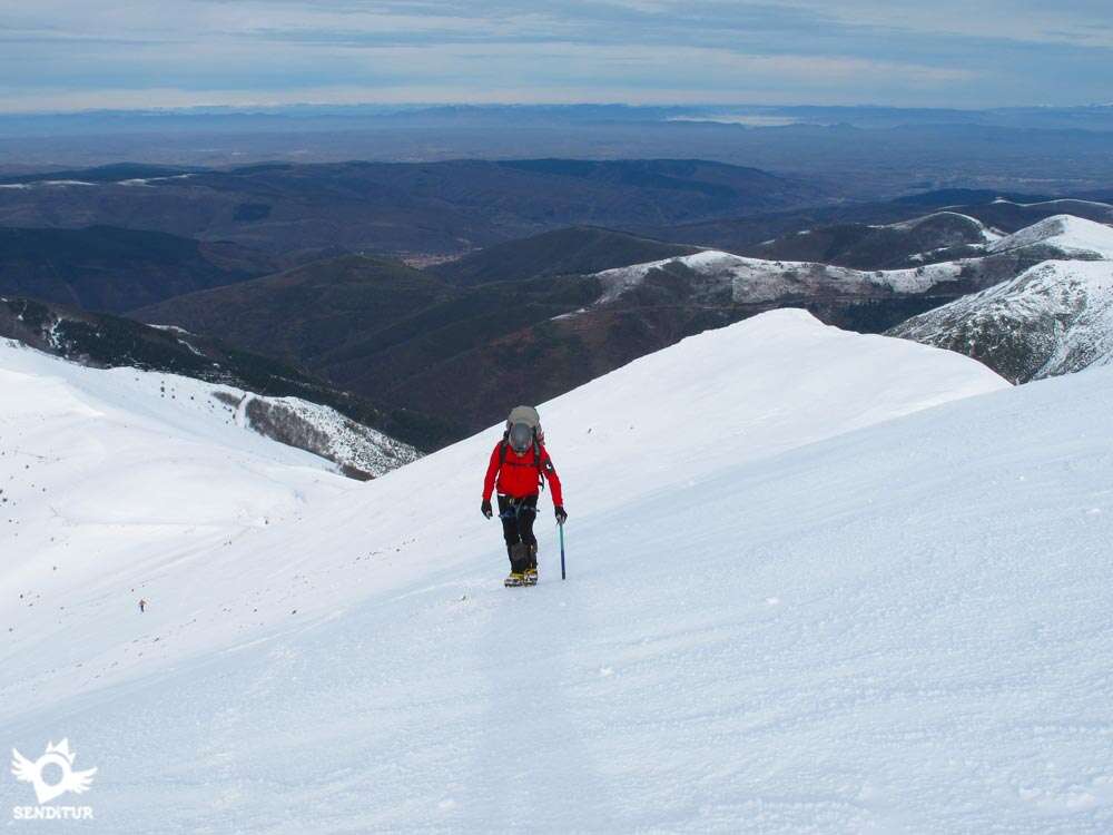
Continuing along this path, leaving behind us the detour that returns towards the tracks and the refuge, we will leave the thick forest where we will be able to contemplate the landscape that extends to our right. The path passes through the pass formed between Cerro Turraguas and Cerro Colocobia where part of the splendour of the Sierra de la Demanda is shown before us, from here leaving the main path the route continues its ascent through a less comfortable track than the previous one in search of the chairlift house that marks the beginning of the final part of the ascent, it continues along the path that zigzags along the western slope of the mountain until it reaches the summit of San Lorenzo 2271 m, the panoramic view from its summit is spectacular as you can contemplate the mythical peaks relatively close by and even sense the Pyrenees on days of good visibility.

From its summit, the route descends quickly on the opposite side of the ascent, that is, on the eastern slope, and after leaving behind another chairlift hut, we arrive at the Nestaza pass where the ascent begins that will take us to the top of Cabeza Parda 2116 m. This summit allows us to enjoy the valleys that surround us, as well as the range of peaks that form the nearby Pancrudos. The descent of Cabeza Parda following the range of peaks that surround Valdezcaray leads us to our next destination, a short ascent that ends at the top of La Cuña 2009 m, a summit that shows us with perspective almost the entire journey, as well as the wide valley of Oja that is away from our eyes. Returning by our steps the route descends by the old route of a chairlift, today firewall in summer and an improvised ski slope in winter, until the main building of the station to follow from this one by the track that leads to the Valdezcaray parking lot.
At the ski resort of Valdezcaray, 18 km from Ezcaray, we arrive following the LR-416 that goes up to the slopes. In the road LR-415 that joins Ezcaray with Posadas this way of access to the station begins. Ezcaray has a daily bus service that communicates it with Stº Domingo de la Calzada and Logroño. In addition, during the ski season the resort has a so-called white bus to get there. Ezcaray can be reached by following the LR-111 from Stº Domingo de la Calzada or by this same road but from the neighbouring town of Burgalesa de Pradoluengo. Once in Ezcaray following this road we find, near the church, the crossroads that leads us to Posadas and the ski resort of Valdezcaray, continuing then by this detour we will cross the river Oja and we will turn to the right to continue by the road LR-415 where to few Km is the detour where the road LR-416 of ascent to Valdezcaray begins, this road in snow season ends in the station parking lot, in summer it is possible to continue later with the vehicle, but already the road ends up becoming a road by the action of snow and ice.
The route is mainly along dirt roads and paths made up of small clumped slabs, in winter it is constantly on snow and ice.
There are no water points along the entire route except for the streams near the ski resort, especially in summer.
Just as in the middle of winter it is only usual to find some more pets and from afar with the animals that live in the area, roe deer and wild boar, in summer it is cattle territory being normal to find sheep and goats around the summits taking advantage of the fresh stems of the bushes and the cows through the pastures of the lower slopes.
This route starts at the Valdezcaray car park (0h 00min), just at the end of it begins a partly asphalted road that in winter is used as a track where some skiers descend, so the snow that accumulates is usually well compacted.

Following this track shortly after leaving the car park and in the middle of a curve, we will leave on our left the path that ascends to the second level of the resort and where skiers descend, to follow the track that gradually taking height, and without the conditioned snow.

After leaving behind a children's hostel, the forest through which the path runs is giving way to pastures and bushes allowing us to see, if the snow does not cover it, as the path turns changing the orientation of its ascent to see face the first peak of the day, before reaching this curve we have the possibility of shortening by climbing the steep slope that separates the two heights of the road, in summer is clearly seen the path that saves the first unevenness with the path. Once crossed the chosen option we will arrive where these meet again for right in front of us to see our diversion (0h 45min), the main track continues for the right cutting the skirt of the mountain, gaining softly height until arriving at the parking lot of the hill of the San Lorenzo and for the left, the way by which we will continue, that gains altitude quickly bordering the slope of the Hill Colocobia.

In summer the roads are clearly visible while in winter the area tends to accumulate large amounts of snow, even disappearing all traces of them, except for a couple of signs, a metal one, another of wood and the remains of a wooden barrier that prevented vehicles from passing. The path climbs up the slope of this hill, with snow not having the reference of the track we must be careful and choose our path well, at the end the path leads to a service track of the station that passes between two promontories, following this track to the right we reach the Colocobia lift, starting point of the real ascent.

In the esplanade of the lift next to the chairlift house, just in the corner of the parapet that protects it something of the wind begins, if the snow does not cover it, the path that will lead us to the top, to the few meters of route is forked in two, a turn to the right to undertake directly the long ascent by the skirt of the mountain, while the other continues straight on in the direction of the Hoya Corridor, slowly ascending for now, this beautiful route reaches the base of the right shoulder of the mountain and between impressive views ascends this crest, to join in the first before summit, with the path that ascends directly by the slope.

Climbing this spectacular route as well as in summer is fully recommended not involving difficulty, whether concentration, with situations of rain, ice or snow requires experience to assess the possibility of doing it. The path of ascent by the slope of the mountain, a canchal in summer, habitual ascent and more if there is snow, continues until arriving at the first before summit. When the snow covers all this slope becomes a shovel with a certain inclination that depending on the state of the snow, can come to impress the less accustomed. From this summit we can see the entire northern face of the mountain, its Hoya Corridor and the next summits that await us.

The ascent continues by the comfortable right shoulder, after a first hard steepness the slope is losing step by step inclination to arrive at the top of the San Lorenzo (2h 25min), maximum altitude of the day.
From here and by the opposite slope to the ascent we begin the rapid descent with enough inclination at the beginning and that in summer is an uncomfortable plasterer, it will take us to pass next to another chairlift and following the straight ski slope to arrive at the hill of Nestaza where the ascent to our following summit begins.

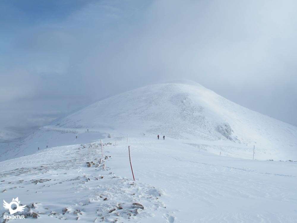
This ascent is more comfortable than the previous one, with less unevenness and something smoother allows us to reach the summit of Cabeza Parda with a certain speed (3h 00min), in winter the snow tends to accumulate on the southern slope, forming a long visor that we must avoid.

The descent can be made by going backwards through the same place of ascent, to go out to the ski slope and continue descending through it until it turns, when we leave the slope to join the second option of descent from the top of the Cabeza Parda, that leaving to our left the San Lorenzo and the way of ascent that we have followed, descends straight by the steep slope of the mountain, this descent is more comfortable when the snow smooths the terrain.

Once at the pass, the route continues in search of the next summit of the day, practically in a straight line, leaving on our left a firebreak, converted into a ski slope, through which we descend, which goes down to the main building of the resort and on our right the beginning of the path that leads to the valley of San Millán.

It is a short but deceptive climb in the form of false summits that takes us to the true summit of La Cuña (3h 30min), the lowest mountain in the route but with a magnificent panoramic view.

From here, if there is no snow, or not enough, it is better to return through our steps to the beginning of the previous firebreak to descend through it, if on the contrary we have the right amount and state of snow we can, half way back, divert the descent to join the firebreak near its half and from there go down to the main building of the resort to after crossing it continue the descent by the ski slope on the right that descends directly to the Valdezcaray Car Park (4h 10min), where the route ends.
 Distance. 10.6Km
Please note that the starting point from which you start the route will influence the distance of the route.
 Time. 4:10h
Total time of the route with hard snow, the times of this route can vary considerably depending on the state of the snow and the speed with which it allows us to advance.
 Time of year
In winter the area accumulates a large amount of snow that allows us to enjoy magnificent views while we do the activity. In summer it is an accessible and advisable route to enjoy mountains of more than 2,000 m and with a greater probability of good visibility to entertain us contemplating the wide panoramic that they offer.
 Required equipment
Material such as mountain boots, crampons and walking ice axe, depending on the state of the snow the route allows you to do it using snowshoes or mountain skis, at least in part. Technical and warm clothing, backpack, gloves, cap, sunglasses and sunscreen, canes, water and food.
 Difficulty. High
Physical
Physically demanding route, both for its distance and the unevenness to overcome, we must not forget that you climb and descend three peaks of more than 2,000 m. In addition, the state of the snow can considerably extend the effort.
Severity of the environment
Without a great technical difficulty for someone accustomed and with the necessary experience in the use of specific material for ice and snow. The ascent by the crest of the right shoulder up to the top of the San Lorenzo with ice or snow is not recommended for its exposure and the snow cornices that are formed. The wide slopes with soft snow hide more than one trap, not being able to see the holes between the bushes or between the rocks, we can put the leg being dangerous, especially in the descents.
Orientation
Without any signposting, in summer the paths and tracks are perfectly defined and with good visibility, in addition we have as reference the top of San Lorenzo and the ski resort. With the snow-covered terrain that reaches, at some points, to fill the gap that the road ate to the mountain, we have to identify the three peaks, clearly visible from the car park, so that next to the ski slopes we serve as reference. Fogs and rapid weather changes are common in the area.
 |
 |
 |
 |
 |
| 1-Valdezcaray car park | 0:00h | 1554m | 0Km | 30T 502278 4678255 |
| 2-Detour | 0:45h | 1758m | 2.4Km | 30T 500504 4678433 |
| 3-San Lorenzo | 2:25h | 2271m | 5.2Km | 30T 502263 4676711 |
| 4-Cabeza Parda | 3:00h | 2116m | 6.8Km | 30T 503629 4677560 |
| 5-La Cuña | 3:30h | 2009m | 8.3Km | 30T 503133 4678963 |
| 6-Valdezcaray car park | 4:10h | 1554m | 10.6Km | 30T 502278 4678255 |
Coordinates UTM Datum WGS84

 Slope: 1884m
 Slope +: 942m
 Slope -: 942m
 Maximum altitude: 2271m
 Minimum altitude: 1554m

This sketch of the route is not made to scale nor does it contain all the information relating to the area, it is merely indicative.

![]()
This schematic with the path is approximate and has been created from the derived cartographic base © Instituto Geográfico Nacional "Cuadrante 240 1:50.000".
Senditur has manipulated the tracks to correct the aberrant points that may exist, caused by problems with the reception of the GPS signal. In any case the tracks are always approximate. SENDITUR encourages you to use the new technologies within your reach, using them as support and consultation in your activity, not basing the realization and orientation of the same only and exclusively on them, since they may see their functioning altered by very diverse causes, not functioning correctly and their indications may not be precise.


Con nieve muy bonito y sin ella todo sale a la luz. http://alavaentusbotas.blogspot.com.es/2015/10/vuelta-por-el-techo-de-la-rioja-montes.html En cualquier época del año espectacular.


Habrá que ir a conocerlo.


Una preciosidad de recorrido, y magníficas vistas!!!

Location of the Virgin of Valvanera, Patron Saint of La Rioja

Cradle of the Castilian and pantheon of the seven Castilian heroes


Find out what to see in...
¿Did you know that...
On 10 August, the day of San Lorenzo, patron saint of Ezcaray, a pilgrimage to the summit is usually made, in which a mass is celebrated at the altar that the Virgin of Valvanera has at the summit itself, formerly officiated by the abbots of the Monastery of Valvanera.
Don't miss out...
Usually and coinciding with the festivity of San Lorenzo, the 10th of August, the most intense night is usually spent in the Tears of San Lorenzo or Perseidas, having a privileged balcony to contemplate this shower of meteors, in the car park which is reached by continuing along the main road that leaves the station.


From the commitment of SENDITUR with Nature and the respect to the balance of the environment, SENDITUR urges you to travel in a responsible way, with low environmental impact and respecting at all times the Natural, Cultural and Social environment wherever you go.

Besides sharing with all of us your experience on the route we would be grateful if you could write to us to inform us of any erroneous or outdated information you may have found, or simply to let us know what you think at Thank you.
This route has been carried out in the field by SENDITUR on 18-01-2016. The route may vary greatly depending on the time of year, weather conditions and terrain, as well as the actions of third parties and the evolution suffered in the natural environment where it is located. All opinions, advice and/or assessments made by SENDITUR in their descriptions are for guidance only and are subject to and/or refer to the specific conditions of the specific day of the route, referring to that specific day, taken from trained people, with the appropriate experience and with a high level of physical and technical preparation as a reference, as well as correctly equipped.
All the times are approximate and take an orientative character, the stops have not been taken into account, no matter how small they are. All the information related to the route, texts, images, videos, maps, diagrams, tracks, towns, and places of tourist interest are published as a guide, and may not coincide with the current state of each place. Before undertaking any activity, assess your technical knowledge, your physical condition, find out about the weather and the variations that the route may undergo, equip yourself correctly, be prudent and responsible at all times, and do not exceed your capabilities. SENDITUR is not responsible for any misuse or inappropriate use of the comprehensive guides of its routes and/or publications as well as its electronic guides, nor for any variations in their descriptions for the aforementioned reasons, and recommends that everyone be responsible and prudent in carrying out the activity. We also encourage you to read books and specialised guides to complement the information described above.
Continue watching …


.jpg "Go to Monastery of Valvanera")
.jpg "Go to Monastery of Suso")


