Welcome to SENDITUR.COM · paths · routes · tourism


Route of the seven bridges of Azárrrulla
A route for the whole family
![]() Difficulty-Medium
Difficulty-Medium
![]() 3:30 h.
3:30 h.
![]() 10.1 km.
10.1 km.
A route for the whole family
![]() Difficulty-Medium
Difficulty-Medium
![]() 3:30 h.
3:30 h.
![]() 10.1 km.
10.1 km.
Not far from Ezcaray, one of the most visited hiking routes in La Rioja awaits us. It is the route of the seven bridges of Azárrulla, the village from which it takes its name and from where this entertaining route starts in the middle of nature. The route actually has two possible circular itineraries that share the same first sector and then return to Azarrulla through different areas.

One route, with an itinerary of 13,84 km and another, the one we are going to do, of 9,88 km, which starts as soon as we pass the village of Azárrrulla in the direction of Posadas. This emblematic route of hiking of the region of Ezcaray takes us to furrow the course of the Usaya river crossing each one of the seven bridges of wood that save their course. A route, in one part, surrounded by the imposing beech forest that surrounds the river. After crossing the seven bridges, we will arrive at the junction with the Altuzarra path 4,76 km, at which point we will have to decide on the return route.

If we choose the option of Altuzarra, the ruins of this old village and a notable descent to Posadas await us, and from there we return to Azárrrulla along the Camino de la Herradura. On the other hand, if we choose, as it is our case, to return by the shortest route, we will find ourselves crossing a dense pine forest until arriving at the Solana de Usaya and from there we will undertake a long descent that take us to pass next to the old mines of Ortaura, just before finishing this route of hiking.

Not few people, after reaching the seventh wooden bridge, return along the same route, thus avoiding the area without shade and enjoying again this beautiful stretch of the route. But you can also, if the heat is too hot, take advantage of the first hours of the morning and do the itinerary in reverse as described here. Leaving for the end, when the sun is more intense, the shaded area of the beech forest.
Ezcaray can be reached by following the LR-111 from Stº Domingo de la Calzada or, by this same road but from the neighbouring Burgos town of Pradoluengo. Once in Ezcaray, following this same road we find, near the church, the crossing that leads us to Posadas and to the ski station of Valdezcaray. Continuing then by this deviation we will cross the Oja river and we will turn to the right to continue by the LR-415 highway where to few km is the deviation where the LR-416 highway of ascent to Valdezcaray begins, which we will leave behind continuing by the highway of the villages that takes to us until Azárrulla. As soon as we cross the village, following the road, we will find on the right hand the parking where we will be able to park our vehicle and to initiate the route.
Look at the picture of 360º
A nice tour for our partner, without great difficulties but where it is important that he is in good physical shape. Watch out for the hot days on the return leg, there is no shade and he can have a hard time.
Water should not be a problem, especially in the first half of the route. However, we can't face the final stretch without bringing enough water.
Being, par excellence, an area of cattle, we are sure to encounter them and of course the ticks will be at their ease. A lot of attention also to the vipers, usually they are more habitual in this zone of what we imagine.
The parking lot next to the road to Posadas, just outside of Azarrulla (0h 00min) is the starting point for this interesting tour.

As soon as we step across a Canadian pass we leave a path on our right that goes up the slope, where we will return.

The path, from the first moment begins to gain height without major complications. Shortly after, we arrive at the crossroads where we can also return to the end of the route.

At all times the white and yellow marks indicate the route to follow, although for now you can't get lost.

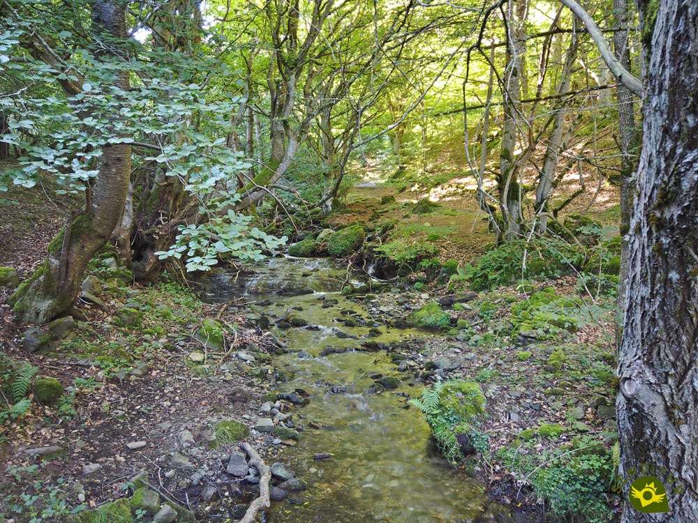
We continue our ascent by gradually entering the valley through which the Usaya River flows, one of the protagonists of this hiking route in La Rioja. A stream that we will approach with every step we take.

We walk surrounded by an imposing beech forest that will accompany us in this part of the itinerary.

After a while we arrive at the first of the seven bridges that we will have to cross. The unevenness continues to make us gain height with every step we take.

An effort that is rewarded with the landscape around us and the sighting of the next bridge to cross. We continue to go up the course of the creek, without barely separating from it.

Crossing it several times, thanks to the wooden walkways that give name to this route. Every time we change slope a new ramp awaits us, which sometimes forces us to make an extra effort to overcome it.

Each bridge we cross allows us to stop on the way, to enjoy the surrounding landscape and to catch our breath. There will be several streams that we will have to cross and that feed the Usaya.

The narrow wooden footbridges of this route do not suppose greater complications, although if it is necessary to cross them with precaution.

After a while we said goodbye to the stream to start one of those demanding ramps. A stretch that takes us straight to the steepest area of the entire route.

Actually this step coincides with the usually dry riverbed of the stream, forcing us to look for the access to the continuation of the path.

Shortly after overcoming this obstacle we reached the penultimate bridge of the day.

To quickly reach the seventh and last footbridge of how many we will have to cross today, as long as we do not return by the same route.

As soon as we cross it, in front of us, we will see the path by which we must continue, leaving the way by which we arrived until here.

A path that zigzags along the side of the mountain, making us gain height quickly.

This path ends just when it meets the Altuzarra crossroads (1h 55min), where we will have to decide which return route to follow.
In our case we follow the path of the Solana Usaya, to return by this slightly shorter path to the parking lot.

Once again we will cross the Usaya stream, but this time without a bridge to avoid getting wet. This section of the route takes us surrounded by tall pine trees that for now protect us from the sun.

Also the unevenness gives us a break allowing us to move forward with some speed. After a while we arrive at a sheepfold, at which point we must be attentive to the posts that indicate the direction to follow.

We descend a few meters to our left, passing between two pines, in search of the continuation of the path we are following.

Almost hidden by the ferns we see the post that marks the beginning of the path inside the forest. We then began the long descent that lies ahead, saying goodbye to the precious shadow that had accompanied us until here.

A long stretch of path awaits us ahead, crossing the mountainside. A path whose route we can almost see in front of us as we go along.

There will not be many crosses that we will find, but we should be careful not to get confused and follow a wrong path. As in previous sections we will have to go through small streams that descend downhill.

After a while we will be approaching the village of Azárrrulla that we used to see so far away.

Our path reaches its end when it meets the path that goes up from the parking lot we exited.

A path that we can follow to the parking lot, obviously leaving behind the route we took up to the seven bridges. Or we can follow the trail that descends directly to the Canadian pass that we crossed at the beginning.

A path that, without further complications, takes us back to the path where we started this route, to reach the end of its route in the parking lot of Azarrulla (3h 30min).
 Distance. 10.1Km
If we decide to return via Altuzarra, we will travel a little further than the distance mentioned here.
 Time. 3:30h
Taking or not taking the detour at the end of the route to reach the parking lot hardly alters the time it will take to complete this route. We must take into account the multiple stops that we will make and that will increase this figure.
 Time of year
This is a path that invites you to walk it practically all year round. When walking through a beech forest, autumn is perhaps one of the best times we will find. The riverbed of course marks in part the beauty of the itinerary. In general they have to be very dry years so that this one does not accompany us with sufficient volume.
 Required equipment
The notoriety of this trekking route in the Ezcaray area means that many people are encouraged to take it. We must never forget that we are in the middle of nature and although getting to the seventh wooden bridge is not very complicated, the return will take us along less wide paths that are clear of vegetation. If we add to this the warning that in many places of the zone we will find warning us of the habitual presence of vipers, it takes us to recommend more than ever the long pants and the light trekking boots. Consult our list of material and equipment for hiking. Read more.
 Difficulty. Medium
Physical
We have to find some ramp of certain entity, but that with the necessary calm would not have to put us in problems. The most evident unevenness we face it of descent, at least in this case. Even so it is a route that demands us to be accustomed to this type of routes.
Severity of the environment
Except for a short, more abrupt section, the route runs along ways and trails that are generally in good condition. However, we have to pay attention to the crossing of streams and the passage through the footbridges to avoid slips that could end up in falls.
Orientation
Marked with white and yellow marks, better preserved in the stretch of the Usaya River than in the return path, the route should not give us more headaches than to decide the way to follow for the return. This return stretch is the one that requires us to be more attentive so as not to skip the marks at the different crossings we will pass through.
 |
 |
 |
 |
 |
| 1-Parking | 0:00h | 930m | 0km | 30T 497322 4679180 |
| 2-Crossroad Altuzarra | 1:55h | 1450m | 4.76Km | 30T 500419 4676750 |
| 3-Parking | 3:30h | 930m | 10.1Km | 30T 497322 4679180 |
Coordinates UTM Datúm WGS84

 Slope: 1180m
 Slope +: 590m
 Slope -: 590m
 Maximum altitude: 1485m
 Minimum altitude: 930m

This sketch of the route is not made to scale nor does it contain all the information relating to the area, it is merely indicative.

![]()
This schematic with the path is approximate and has been created from the derived cartographic base © Instituto Geográfico Nacional "Cuadrante 240-1, 240-2, 240-3 y 240-4 1:25.000".
Senditur has manipulated the tracks to correct the aberrant points that may exist, caused by problems with the reception of the GPS signal. In any case the tracks are always approximate. SENDITUR encourages you to use the new technologies within your reach, using them as support and consultation in your activity, not basing the realization and orientation of the same only and exclusively on them, since they may see their functioning altered by very diverse causes, not functioning correctly and their indications may not be precise.


Un recorrido precioso, el tramo de los puentes por el hayedo nos gusto mucho.

Location of the Virgin of Valvanera, Patron Saint of La Rioja

Cradle of the Castilian and pantheon of the seven Castilian heroes


Manganese mines whose exploitation is probably one of the oldest in Spain

Romanesque jewel from La Rioja

Find out what to see in...
¿Did you know that...
You are in front of a route with a great variety not only of landscapes, but also of animal and vegetable species. Along the way you will be able to see everything from beeches, wild pines, white firs and heathers, to deer, badgers, otters and various birds of prey.
Don't miss out...
The visit to the recreational area of Bonicaparra It is an old uninhabited area of which today only a solitary refuge of mountaineers remains. There, besides enjoying the environment that surrounds it, you will be able to spend a pleasant time resting.


From the commitment of SENDITUR with Nature and the respect to the balance of the environment, SENDITUR urges you to travel in a responsible way, with low environmental impact and respecting at all times the Natural, Cultural and Social environment wherever you go.

Besides sharing with all of us your experience on the route we would be grateful if you could write to us to inform us of any erroneous or outdated information you may have found, or simply to let us know what you think at Thank you.
This route has been carried out in the field by SENDITUR on 19-08-2020. The route may vary greatly depending on the time of year, weather conditions and terrain, as well as the actions of third parties and the evolution suffered in the natural environment where it is located. All opinions, advice and/or assessments made by SENDITUR in their descriptions are for guidance only and are subject to and/or refer to the specific conditions of the specific day of the route, referring to that specific day, taken from trained people, with the appropriate experience and with a high level of physical and technical preparation as a reference, as well as correctly equipped.
All the times are approximate and take an orientative character, the stops have not been taken into account, no matter how small they are. All the information related to the route, texts, images, videos, maps, diagrams, tracks, towns, and places of tourist interest are published as a guide, and may not coincide with the current state of each place. Before undertaking any activity, assess your technical knowledge, your physical condition, find out about the weather and the variations that the route may undergo, equip yourself correctly, be prudent and responsible at all times, and do not exceed your capabilities. SENDITUR is not responsible for any misuse or inappropriate use of the comprehensive guides of its routes and/or publications as well as its electronic guides, nor for any variations in their descriptions for the aforementioned reasons, and recommends that everyone be responsible and prudent in carrying out the activity. We also encourage you to read books and specialised guides to complement the information described above.
Continue watching …


.jpg "Go to Monastery of Valvanera")
.jpg "Go to Monastery of Suso")


