GR 190 Section 1 Ezcaray-Valvanera
A pilgrimage through the mountains to Valvanera
A pilgrimage through the mountains to Valvanera
In the heart of the Sierra of La Demanda between the Oja valley, in Ezcaray, and the Monastery of Valvanera, runs this spectacular section of the GR-190, also known as that of The High Valleys Iberian. Leafy and varied forests of beeches, pines and firs, spectacular panoramic views of the valleys and the rounded peaks of more than 2000m that form the Sierra of La Demanda, is part of what this GR-190 offers us, a luxury at every step.

The GR 190 section 1 Ezcaray-Valvanera with 22.7 km gives us the opportunity to cover part of the old road that linked Ezcaray with the Monastery of Valvanera. We will go into the Sierra of La Demanda, passing emblematic peaks such as La Cuña, El Cabeza Parda or Los Pancrudos, among others, all of them observed by San Lorenzo, which with its 2271m is the highest mountain in La Rioja.
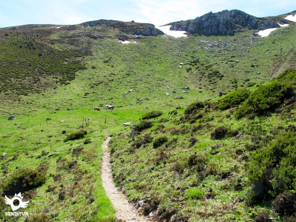
The itinerary takes us through the valley of the river Oja following the upper course of the river Cárdenas, in the valley of San Millán de la Cogolla, the Tobía and the river Valvanera in the valley of the Najerilla, offering us from any of them some splendid panoramic views of its flow towards the valley of the Ebro. From the beginning, in the old building of the Bobadilla train station that linked Ezcaray with Santo Domingo de la Calzada and Haro, the path shows us its character ascending through the dense forest to find a good number of pass where we will cross to another valley.

Pass and pastures that teach us the marked livestock tradition of these lands, to reach the spectacular spot where the historic Monastery of Valvanera is located, patron saint of La Rioja. In the Monastery of Valvanera we will also find the beginning of the GR section that joins this GR 190 of the High Iberian Valleys with the GR 93 on its way through the town of Anguiano.
Formerly the habit with which the Benedictine monks and friars who inhabited the monastery of Valvanera and San Millán de la Cogolla wore, La Cuculla, gave its name to San Lorenzo, given the similarity between the snowy summit of the mountain and the hood of the Benedictine habit.
Ezcaray can be reached by following the LR-111 from Santo Domingo de la Calzada or by this same road but from the neighbouring town of Burgos Pradoluengo. The road LR-111, allows us to connect to the height of Haro with the AP-68. In Santo Domingo de la Calzada you will also find the N-120 and the A-12 dual carriageway between Logroño and Burgos. Ezcaray has a daily bus service, which connects it with Stº Domingo de la Calzada and Logroño. Once there following the LR-111 we find, close to the church, the crossroads that leads us to Posadas and the ski resort of Valdezcaray, continuing then by this detour we will cross the river Oja and in front of us we will find the building of the old train station and the parking area where we can leave our vehicle.
Hard journey for our friends, by trails and dirt paths generally in good condition, between heather bushes and brooms that fortunately usually leave enough space.
Livestock area par excellence, it is common to find livestock, usually cows and calves that join the already nurtured habitat of the area.
Interspersing shady areas in the woods with large stretches without it, we will find a couple of water points, troughs for livestock, interspersed in the path but do not avoid the need to carry water as it is not certain that we have it in these places. Of course, both at the beginning and in Valvanera we will be able to replenish the containers.
![]() Next: Section 2 Valvanera-Viniegra de Abajo
Next: Section 2 Valvanera-Viniegra de Abajo
Variant: Link GR 93 GR 190 Anguiano-Valvanera
The route begins in the car parks next to the building of the old railway station of Ezcaray (0h 00min), crossing the road in direction Posadas until arriving at the height of the pillars of a collapsed bridge next to an informative sign of the road, place where turning to the left begins the footpath that ascends by the slope, this crossing is signposted by the sign of the GR.

The trail quickly gains height until it reaches the crossroads with the Turza road that we must cross, but instead of climbing straight up the slope, if we go up the road a few meters to turn the curve where the path leads to us, we find some stairs that help us to cross the slope more easily.
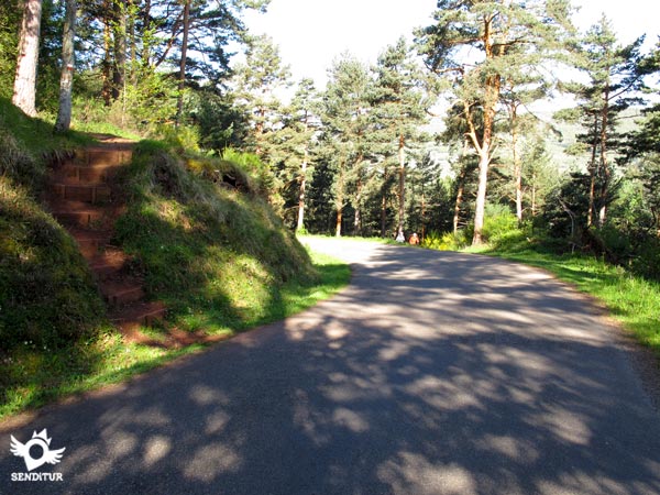
The route continues through the interior of the pine and beech forest, zigzagging along a well-marked and signposted footpath, going up the hillside.
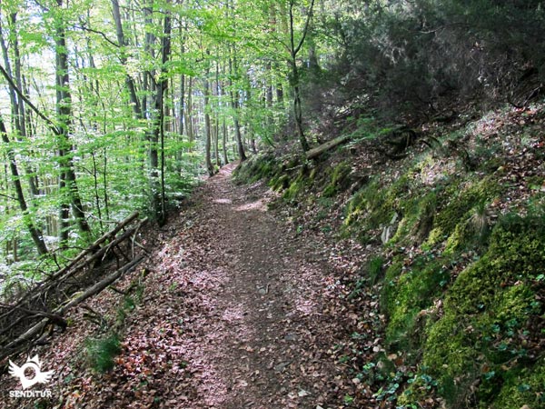
On our way we find a good number of small footpaths that, if followed, would shorten the curves that describe the true itinerary of the GR, wider and more comfortable than these demanding shortcuts.

The itinerary, which has now become a forest track, exits for a moment from the thickness of the forest, to turn left, leaving a trail on our right.

Continuing the track without leaving it at any time we will arrive at the exit of the forest for shortly after, in the Pass of Sagastia (1h 35min), to find us with a well-defined dirt road that cuts the run of the GR.

On the other side of this path, the route now turned into a footpath continues, on the slope of a hill. If you take the route in the opposite direction when crossing the dirt track, avoid the path on the left that goes towards the hill and follow the path on the right that descends towards the forest.
Our GR leaves a few footpaths to the right and left, alternating somewhat stark areas with moments when it is covered by the grass, to continue the ascent along the slope of the mountain and without the protection of the shady forest.

The route is smoothed without completely losing its profile, giving us the opportunity to contemplate the beautiful panoramic view that form the valley next to San Lorenzo.

After leaving a well-defined footpath on the left, we arrive at a sheepfold that we will cross turning a little to the right to continue along the upper footpath, of the two that we can choose, and follow the ascent along the same slope of the mountain.

Leaving behind a battered trough and after passing a small hill, where the path blurs in the grass, we arrive descending until the pass of the Marulla.

Crossing this pass straight ahead, passing by a small weather station on the right, we come across a dirt track that cuts our way from left to right.
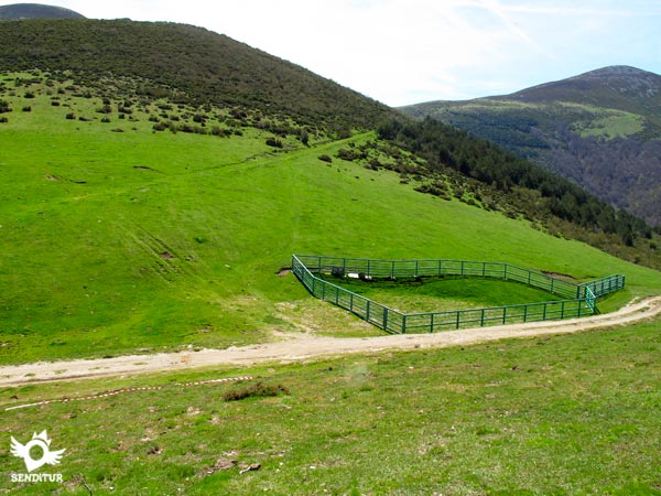
Crossing this track next to a fence for livestock and continuing straight on, we will take up the path, now covered with grass, which continues to cut the foothills of the mountain.

This green path accompanies us through young pines until we reach the beginning of a trail that on our left starts the short ascent to the Pass of Beneguerra (3h 10min), where thanks to a wooden ladder we can jump the fence in the muga between Ezcaray and Pazuengos.

We descend a few metres to the encounter of a path and following it to the right, the route borders the hillside of the mountain and narrows at each step until it becomes a small footpath, just before entering the high area of a forest, to undertake a gentle descent between brooms towards the ravine of Campos Largos.

This part of the route shows us the valley and in the background San Millán de la Cogolla, after crossing the stream in the ravine and crossing the beech forest, we continue bordering the Cabeza Parda leaving to our left a footpath and crossing a small sheepfold to arrive where we must cross the remains of a wire fence and continue for the slope of the mountain in search of the track of Nestaza.

At this point we turn left, leaving behind us the watering hole and beginning the descent along the dirt track until we find a trail on the right, which leaves it to enter the forest, just before one of its pronounced and characteristic curves.

This trail, which we must follow, passes a cobbled hillside and crosses a small ravine to continue through the forest between beeches and some waterfall, and guided in the final part of its route by a wire fence will bring us closer to the Pass of Saleguillas (5h 00min), where another wooden ladder is used to jump the fence.
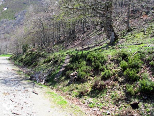
As soon as you cross this fence, you will come across a dirt track where, turning right, you will continue with magnificent views of the Tobía valley. Right at this very spot, you will come across the signs indicating the Routes through beech forests. In front of us is the route that connects our GR 190 with the Rajao beech forest.

This forest track leads us to the well signposted detour to the Monastery of Valvanera, where we leave the GR path that would take us to Viniegra de Abajo, to continue along the path on the left towards our target.

This new track descends between pine groves, leaving it, after a while, to our left to continue, through a kind of firebreak, parallel to it, next to the edge of the forest, in search of the point where turning to the right we will enter the forest.

We begin the descent along the footpath that runs through the thick forest. Once again we come across the dirt track, which if we followed the descent, would also take us to Valvanera.

Here we come across another of the signposts indicating the Routes through beech forests. In this case it is the link that allows us to join, from here, the Valvanera Route on its way to the Cervanco pass, from where we can continue on to Anguiano, Tobía or Matute, or go down to the monastery. Crossing this track, we continue along the footpath that on the other side continues down through the forest and avoids travelling along the winding route of the track to Valvanera.

The trail, in some moments decomposed, comes again to the meeting with the track that we left behind, for now yes to follow it a good stretch until, after a closed curve to the right, after passing a small fence to the right of the path, find the hidden sign to the left of the dirt track that marks the beginning of the trail that descends quickly through the forest.

We continue the descent by the footpath leaving as many detours we find, passing next to a water deposit and some beehives, to arrive until another trail that cuts our course turning abruptly to the right and where we will continue escorted by a wire fence until arriving at the wooden fence of a house.

Crossing this one, to our left there is a metal door that we must cross to continue descending by some stairs first and a small stretch of footpath later, until the Monastery of Valvanera (6h 05min), where this stage ends.
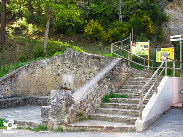
Our starting point in Ezcaray will mark the final distance to be covered.
Total time without stops, it is advisable to take it easy the first part of the route as it is in continuous ascent and then we have most of the journey.
Given the height of the route, in winter it is usually covered by snow, hiding bot:the pat:and the signs. The rest of the year the itinerary offers us a magnificent and colourful landscape, in addition to being able to enjoy the leafy forest that it crosses in its low part.
Footwear and trekking clothes according to the time of the year and to the meteorological conditions, warm clothes and for rain, backpack, walking sticks, canteen and food. Recommended photo camera and binoculars. Consult our list of material and equipment for hiking. Read more.
Physical
A physically demanding stage, largely due to its considerable distance and the significant accumulated slope. In the first section, the largest and most constant ascent ramps are surpassed. Once in the area of the Beneguerra pass, the route starts a continuous uphill and downhill up to the fast and steep descent towards Valvanera.
Severity of the environment
The route runs partly on dirt tracks and mainly on well trodden paths, except for some ravines of streams which, depending on the time of year, may or may not have flow. The pat:in certain areas runs exposed by the foothills of the mountain.
Orientation
Well signposted by the typical marks of the GR and perfectly defined except in the areas of the hills, where the pastures take over the pat:and where we orientate ourselves thanks to the wooden signposting stakes of the GR. When the GR travels along the dirt track, we must be careful because at the points where it leaves the track, althoug:they are signposted, it is relatively easy to skip the detour.
| 1-Ezcaray | 0:00h | 810m | 0Km | 30T 499200 4686083 |
| 2-Pass of Sagastia | 1:35h | 1272m | 4.5Km | 30T 501321 4683639 |
| 3-Pass of Beneguerra | 3:10h | 1739m | 9.1Km | 30T 503618 4680536 |
| 4-Pass of Saleguillas | 5:00h | 1633m | 16.2Km | 30T 506786 4676606 |
| 5-Monastery of Valvanera | 6:05h | 1000m | 22.7Km | 30T 510619 4675374 |
Coordinates UTM Datum WGS84
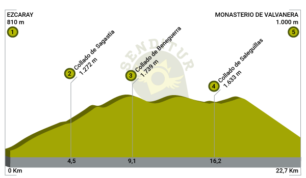
![]() Slope: 2204m
Slope: 2204m
![]() Slope +: 1206m
Slope +: 1206m
![]() Slope -: 998m
Slope -: 998m
![]() Maximum altitude: 1741m
Maximum altitude: 1741m
![]() Minimum altitude: 804m
Minimum altitude: 804m
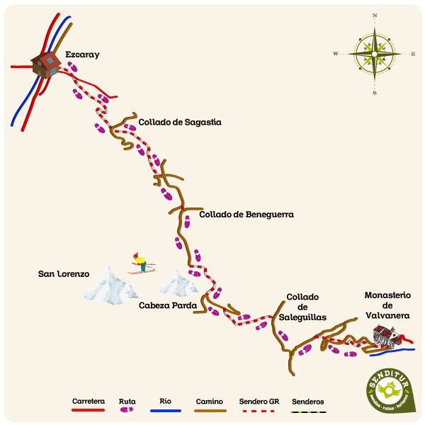
This sketc:of the route is not made to scale nor does it contain all the information relating to the area, it is merely indicative.
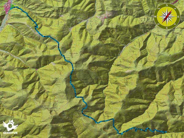
This schematic wit:the pat:is approximate and has been created from the derived cartographic base © Instituto Geográfico Nacional "Cuadrante 240-2, 240-4 1:25.000".
Senditur has manipulated the tracks to correct the aberrant points that may exist, caused by problems wit:the reception of the GPS signal. In any case the tracks are always approximate. SENDITUR encourages you to use the new technologies within your reach, using them as support and consultation in your activity, not basing the realization and orientation of the same only and exclusively on them, since they may see their functioning altered by very diverse causes, not functioning correctly and their indications may not be precise.
¿Did you know that...
The Sierra of La Demanda receives its name due to old lawsuits between Monterrubio de La Demanda and Barbadillo de los Herreros, for the use of land and pastures, which began in the 16th century and continued until the 19th century.
Don't miss out...
The spectacular views from the hermitage of Santa Bárbara, in Ezcaray, of the Oja valley and the Sierra of La Demanda.
From the commitment of SENDITUR with Nature and the respect to the balance of the environment, SENDITUR urges you to travel in a responsible way, with low environmental impact and respecting at all times the Natural, Cultural and Social environment wherever you go.
Besides sharing with all of us your experience on the route we would be grateful if you could write to us to inform us of any erroneous or outdated information you may have found, or simply to let us know what you think at Thank you.
This route has been carried out in the field by SENDITUR on 21-05-2015. The route may vary greatly depending on the time of year, weather conditions and terrain, as well as the actions of third parties and the evolution suffered in the natural environment where it is located. All opinions, advice and/or assessments made by SENDITUR in their descriptions are for guidance only and are subject to and/or refer to the specific conditions of the specific day of the route, referring to that specific day, taken from trained people, with the appropriate experience and with a high level of physical and technical preparation as a reference, as well as correctly equipped.
All the times are approximate and take an orientative character, the stops have not been taken into account, no matter how small they are. All the information related to the route, texts, images, videos, maps, diagrams, tracks, towns, and places of tourist interest are published as a guide, and may not coincide with the current state of each place. Before undertaking any activity, assess your technical knowledge, your physical condition, find out about the weather and the variations that the route may undergo, equip yourself correctly, be prudent and responsible at all times, and do not exceed your capabilities. SENDITUR is not responsible for any misuse or inappropriate use of the comprehensive guides of its routes and/or publications as well as its electronic guides, nor for any variations in their descriptions for the aforementioned reasons, and recommends that everyone be responsible and prudent in carrying out the activity. We also encourage you to read books and specialised guides to complement the information described above.
Continue watching …