This fascinating route, the Ascent to Urbión from Black Lagoon, is located in the Urbión Lagoon and Glacier Cirques Natural Park. This route will take us from this spectacular lagoon, which owes the darkness of its waters to the reflection of the surrounding cliffs, to the mythical summit of Urbión, in the Iberian System, which, being surrounded by a glacial landscape, marks its character by giving it shape. The enigmatic legends that surround the Black Lagoon and its location, nestled between colossal granite walls and lush pine forests, make a visit to this beautiful place essential, which changes radically as we ascend its cliffs where we will find a large wetland, a clear example of the glacial past that is still evident today.

The 14 km route takes us through a lush forest from the visitor reception center where we can leave our vehicle, to the spectacular Black Lagoon, where it calls attention to the huge cliffs that surround it and the darkness of its waters, and also noted for the deposits or moraines that are silent witnesses to the laborious work of the glacier that once was here. From the lagoon, a singular path brings us closer to the portlight through which we will access the pastures through which countless streams run from lagoon to lagoon, leaving the enormous contrasts that, in the short distance of the tour, the landscape suffers as if it will take us to other places much farther than they really are. A high mountain route that will allow us to discover lagoons, circuses, moraines or snowy niches that will undoubtedly surprise us in every corner of the park. As the Ice Lagoon located in a privileged viewpoint from which to enjoy the environment around us, or the Long Lagoon, which houses a rich flora inside, plant species that will vary as the landscape, from the pine forests and beech forests around the Black Lagoon to the shrubs, junipers and blueberries that barely withstand the rigors of winter.

The unmistakable silhouette of the Urbión captures all our glances as we approach the mountain, leaving us just enough time to contemplate the cirques and deep valleys that were formed here. The base of this south-facing mountain is the place chosen by the Duero to be born, while to the north it is the Urbión Lagoon and the extensive panorama on the horizon of the Sierra of La Demanda that demands all our attention. Without a doubt, the summit of Urbión and its mythical cross will require us a good time to enjoy the place where the limits of several provinces and their respective autonomous communities coincide, here it is Soria and La Rioja that share the mountain. On the way back, a less well-known and less frequented peak hides its charms from the visitors to the park. Zorraquín and its sea of slabs placed vertically as if they wanted to join the mountain with the sky, well worth a last effort to climb it. In addition, the summit will provide us with magnificent views of the route so far and the possibility of approaching the next Riscos of Zurraquín, a conglomerate of large stones in continuous balance. After knowing this singular mountain we follow our steps that will return us to the dominions of the pines and the beeches that surround the Black Lagoon, where with luck and patience we will be able to be with the showy marbled newt that usually inhabits this zone, for almost forced to return to the parking, where our wanderings began.

According to the legends, the Black Lagoon has no bottom, they even say that it communicates with the sea through caves and underground currents, and that some people who bathed there have disappeared in its waters, like three sisters who, disobeying their father, a shepherd in those lands, escaped from the cabin where they spent the night to take a dip one warm summer night and they were never heard from again, nor could they be found.
Barely 50 km separate it from Soria, access is via the SO-830 road that links the town of Vinuesa with Montenegro de Cameros and La Rioja, through the impressive Revinuesa valley. We will take a well signposted detour that leads us up a two-way mountain road. It is possible to arrive by car to its surroundings, where after leaving behind a first parking lot and a barrier, we will find a small area where we can leave our vehicle. In the summer months and on public holidays, when there are many visitors, this barrier is closed and we must leave our vehicle in this large controlled car park, after paying the corresponding fee, from where we can choose to walk the barely 2 km of road that separates us from the second car park or take the bus that, enabled for this purpose, goes up and down to the visitors. In addition, the road becomes a one-way street, with an alternative route to the first car park, leaving the usual route for the descent.
Nice route, somewhat demanding both for the unevenness and for the mileage but feasible if our friend is used to our gears. The heat can be a strong enemy that makes the day much harder, since we will not be able to find areas of shade where it can cool down. He should not have any major problems but it is advisable to be attentive to him in the most exposed sections and help him in the small climbs at the end.
The water, although it seems that it is not, is a problem since we will not find points where we can replenish our reserves except at the beginning of the route and in summer the flow in the streams is not guaranteed, in addition the zones of lagoons and wetlands must be respected and protected to avoid their deterioration.
This habitat is chosen by a large number of animals that live there and that at some point we may encounter, although with the influx of people are often hidden even more. The cattle and their canine companions are another of the protagonists, especially if the option we follow is the one that goes up to the frozen lagoon and from there continues along the plains to the Urbión. We must not forget that we are in a protected Natural Area, so information on its regulations will be useful.
The paved track that brought us to the parking lot (0h 00min), from where this route starts, continues its ascent making us walk the distance that still separates us from the Laguna Negra, forced by the barrier that prevents the passage of vehicles in summer and festive season.

From here, we start a heavy journey, livened up by the thick forest that surrounds us and the murmur of the stream that runs a little further down. The slope, not too steep, makes us warm up quickly while the track continues its course.

As it could not be otherwise just where the track describes its only curve we find a shortcut that if we follow it will avoid us a few meters in exchange for crossing a small stream.

Almost without realizing it, we arrive at the second parking lot where, on our left, at the end of the esplanade, the cobblestone path begins that will serve to bridge the gap that separates us from our first stop.

This path ascends quickly, taking us to the vicinity of the fishermen's shelter, where we have the option of going straight on and climbing the stairs that take us directly to the nearby lagoon or continuing on our left following the path of the lagoon stream that borders the cliff that houses it.

The Black Lagoon (0h 30min) awaits us after the stretch of stairs, a wooden footbridge serves us to tour this beautiful place without altering its state more than it already is.
At the end of this footbridge, at the other end of the lagoon, we will join those who have decided to follow the path of the stream, so that together we can save the drainage of the lagoon thanks to some stones that act as an improvised bridge.

We are now following a, for the time being, wide path that borders an esplanade delimited by a wooden base.

At first we must follow the red and white marks that will lead us directly to the portlight where we will save the enormous cliffs that surround the lagoon.

This path winds between large blocks of stones and huge tree roots that for the moment provide us with a pleasant shade. Without much effort we approach the vertical wall where, if the season is right, the water falls forming beautiful waterfalls.

One of these streams stands in our way allowing us to enjoy its spectacular course, thanks to the bridge that crosses it. From here we can see the great unevenness that at this very point we start to overcome.
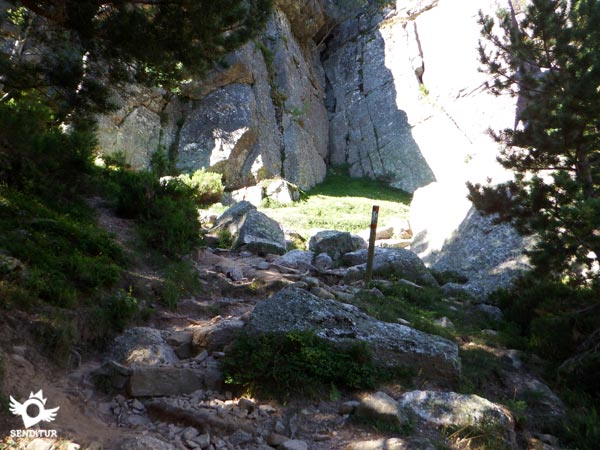
We climb zigzagging among the rocks, taking advantage of the winding and well marked path that intersperses areas conditioned with artificial steps, with others without the relative comfort of these artificial stairs. Soon the path turns abruptly, leading us to the wide corridor where we will reach the top of the cliff.

This stretch with snow or ice becomes very dangerous and technical, putting in serious difficulties the hikers who, without the experience and the appropriate equipment, venture into its ascent without realizing that what is really complicated is to descend this sloping stretch, where with the passing of the hours and of the people what before was a quality snow that facilitated the ascent has become a skating rink.
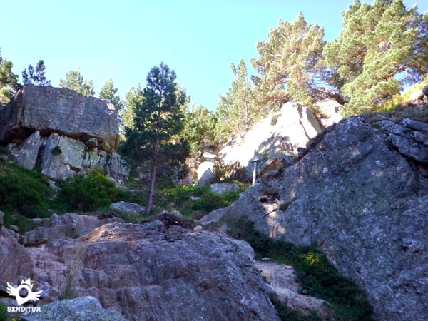
This section is quite decomposed partly because of the large number of people who pass through it and who are determined to seek alternative routes to what used to be a much clearer and more defined path than today. Once at the top, the route turns to the right to leave this portillon and go up to the top of the vertical walls we used to see from below.

A short stretch awaits us, following the path that runs along the edge of the cliff until we find the exit that will take us away from the edge of the cliff.

We ascend, leaving the lagoon behind us, to the very edge of the forest. Here it is important to take the appropriate references that on our return avoid us to follow the path that on the left seems to be the continuation of the return journey, nothing further from reality.
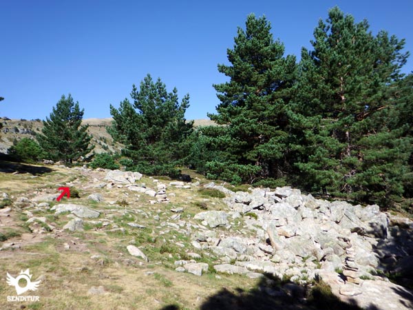
The itinerary turns to the right and almost at the moment it meets the detour that arrives to the Ice Lagoon, path that we can follow perfectly since when arriving at it we will be able to return until this layout or to continue ascending until the shoulder that separates the Mojón Alto from the Urbión and to follow it until the summit.

This route with snow or ice is more advisable than the summer route to Urbión, since it passes through some complicated and dangerous sections if they are snowed in. We leave this detour on our left and follow the path that goes into the trees, taking advantage of the last area of shade that awaits us in a long time.

The trail leads us directly to one of the streams that feeds the Black Lagoon, leaving us to choose between several routes that descend to it, in search of the best place to cross it, which changes according to the flow it carries.

On the other side, we will find another fork in the route. The path on the left goes into the plain, an area of special ecological value that is in full recovery of the vegetation that covers it. This less clear and marked route is not advisable to follow for this reason and to respect and contribute to the recovery of the vegetation.

On our right we will find the signposted path that goes up along a hill following the course of another of the many streams that, as if they were veins, run through this high plain.

This trail leads us to half of the slope, continuing the ascent, no longer so demanding, in which without us realizing the stream that accompanied us has disappeared under the mantle we stepped on.

It is important not to leave the path in order to avoid the deterioration of this bark which is so important for this area and which gives it its special uniqueness. There are many streams and small lakes that we come across and that in rainy seasons are extremely loaded with water, to the point that the ground we are walking on is filled with water, as if it were a fountain, with every step we take.

The route takes us directly to the point of union with the other path, from which we can already see the next hard ramp that we will have to climb. We quickly see ourselves making an effort to gain height by following the thousand and one trails that wind down the slope and take us to the meeting point of the itinerary that reaches here from the Ice Lagoon.

We continue with the ascent leaving aside the path of the lagoon and the one that comes from the nearby Zorraquín, to reach the highest point, where the unmistakable silhouette of the Urbión appears in front of us.

The route then turns to the left to undertake another of the sections, complicated by the fact that it is snow-covered or icy, since it is a side pass that crosses the slope of the mountain at a medium height that ends in a vertical drop from the top of a cliff.

A little before starting the pass we can choose, if there is snow, to go up the shoulder of the mountain in search of the upper route which is safer in winter.

We follow the path that in normal conditions has no major complications and that takes us to the gates of the Long Lagoon (1h 45min), which we reach after passing the hillside of the mountain.
Just as we arrive at the lagoon, on our left we again have another option to vary the course and climb the mountain to join the previous detour and together go in search of the superior route which we reached not without effort.

From here we can get an idea of the convenience or not of this variant since we have a clear picture of the next delicate step that we have to overcome.
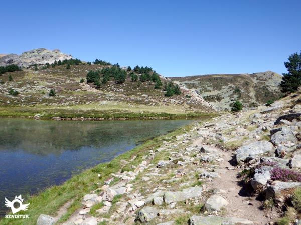
We skirt the lagoon that extends on our left, heading towards its drainage where we will cross it. Here begins another hard ramp that makes us gain height without hardly any rest.

It is in one of them where the path continues along the side of the mountain, taking us to a point where it ends, forcing us to climb a stone in order to follow the course.

Here if instead of following the path, we venture into what looks like a climb between the stones. We will soon realize that by zigzagging between them we can find the real continuation of the path that will avoid that cumbersome and exposed piece.

After another strong and decomposed ramp we will have in front of us the next delicate point of the route, that if it is snowy or with ice we will have to avoid.

Here in winter you can usually see the route followed by the mountaineers who look for, following the shoulder of the mountain, the ideal place to cross the cornice that usually forms the wind at this point.

With mud, it also becomes a complicated pass, right at the end, which is where it has the greatest unevenness and where the terrain is most decomposed due to the erosion and landslides it has suffered. With due caution we set out to save this area, which in fact has no major problem under normal conditions.

We overcome the short final stretch without any problem other than the effort that the slope forces us to make. When we arrive at the top we find a huge plain and the path that follows the shoulder that brings those who decided to follow the high way from the Icy Lagoon.

The Urbión, closer and closer, rises among a labyrinth of stones towards which we are heading. To our left we leave the detour that if we follow it would take us to the source of the Duero, closer than it seems.

Another tough stretch of ascent awaits us, where we will find an endless number of possible routes, many of them with no way out. We go up the mountain, initially glued to its right margin approaching little by little to the labyrinth of stones.

The route changes direction to head towards the wall at the top, here we will have to walk carefully to avoid getting confused and following paths that lead to complicated climbs, which are not necessary.

Soon we find the splendid panorama on the other side of the valley from where we can see all of the Sierra of La Demanda on the horizon. It is here that, hidden to our left, we will find the continuation of the route, somewhat more steep.

For the most adventurous, there is a simple and amusing climb with good prey and almost up to steps, which allow us to climb up on the rocks. Once we are up there, we will embroider the wall to reach the side that had been hidden from us until now.
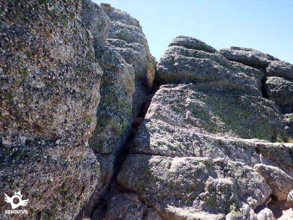
Here is the narrow pass that will lead us to the summit of Urbión (2h 45min), where we will be able to enjoy some marvellous views while regaining strength for the return.
After taking the necessary time to enjoy this summit, we start our way back, following our steps, up to the detour where we left the upper path.

It is important not to skip it or confuse it with the milestones that mark the descent if there is snow. From here and after overcoming, with due caution, the descent from the cliff we go to the Detour to the Zorraquin (3h 10min).

Just when our path turns radically to the right to begin the descent towards the plain of the wetland, if we want to ascend to this singular summit, we have to continue straight ahead towards the imposing hill before us.

It is important not to be confused since the route to be followed begins to gain height quickly by ascending the left side of the mountain, while the path that seems more marked cuts through the right without hardly going up.
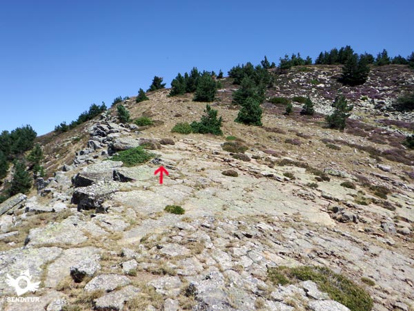
The route demands a new effort that will undoubtedly be rewarded not only by the views but also by the peculiar and characteristic aspect that this summit has.

We continue upwards, now a little further away from the left cut that sinks into the valley, following a path that sometimes seems to disappear but that practically in a straight line will lead us to our objective.

The wide summit of Zorraquín (3h 35min) surprises us with its peculiar aspect and offers us a no less attractive panoramic view of the mountain we have just descended, together with the vision of the cut where the Black Lagoon is hidden.

If we wish, we can go as far as the Riscos of Zurraquín, which we will undoubtedly recognize by its appearance of cubes of stones piled up on top of each other.
The only thing left to do now is to retrace our steps, being attentive to the descent until it joins the previously abandoned route, to avoid getting lost on the way down.
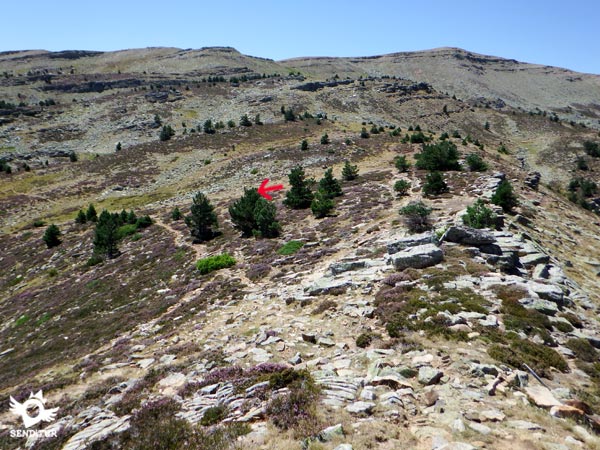
Once there we will continue with the descent towards the stream, leaving behind the detours of the Icy Lagoon and the other variant that crosses the vegetation.

Once in the creek, we will have to cross it again to follow the path that runs through the forest on the other side. Using the milestones and references taken during the ascent, we will leave the path when we reach the Detour towards Portillón (4h 05min), to head towards it.
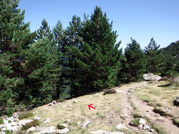
The descent of this section is better to take it easy and look for the most comfortable and safe area for us. Once down we just have to decide which route we follow when we reach the Black Lagoon (4h 20min) of the two possible that we are offered and that once unified will take us to the esplanade where the paved track begins by which we will descend to the parking (4h 40min) where the tour ends.
This figure includes the possible detour to Zorraquín peak.
The detour to ascend to the Zorraquín takes approximately 30 minutes, plus the time we spend enjoying this unique peak. If we decide to approach the Source of the Duero we will have to add another 30 minutes more or less to the total time.
Good weather and the absence of snow or ice is the ideal approach for this route, as otherwise the technical and orientation difficulties are considerably increased. The natural environment is the great protagonist, offering us a great variety of landscapes and colours depending on the period of the year in which we visit it. The water streams that run in the upper plateau and that feed the different lakes forming a real wetland give way to a landscape of glacial origin. The autumn with its striking colors and the periods with enough abundance of water give us a landscape in all its splendor.
On the tour we are continuously exposed to the action of the sun, so it is important to protect from it, hat or cap, sunglasses and sunscreen can not miss at any time of year. Otherwise, in normal conditions of the route, trekking shoes, clothes according to the weather conditions and the backpack equipped with the usual should be enough. Water and food should not be missing either, as we will not find any fountains, except at the beginning. A map and GPS with tracks are essential in case of bad weather or fog and are not too much, even on a sunny day as the changes in the weather in this area are quite fast and it is very easy to get lost. Consult our list of material and equipment for hiking. Read more.
Physical
The route gives us some truce zones where we can recover strength to face the hard ramps that we will find. Basically there are three sections of greater demand, the ascent to save the Black Lagoon cliff, the section to reach the pass of the detour to the Zorraquín and the final section to the Urbión, although it is true that we will be constantly gaining height the rest of the route requires less effort. Taking these parts of greater unevenness with enough calm we would not have to have major complications whenever we are used to this type of routes. The heat can play a bad trick on us and harden the route considerably since almost in its totality we will not find zones of shade.
Severity of the environment
The route passes through some exposed areas, slopes and cliffs, where a person with vertigo or not used to this type of terrain can have a hard time, although with the necessary caution we should not have any complications. It is very important not to underestimate the route and to bear in mind that it is only advisable to do the route if it is not covered by snow or ice, otherwise the level, both technical and of the necessary material, will be considerably increased. The rain also increases the danger of these more exposed sections since the mud and wet stones become real skates. The cliff that gives way to the pass before the Urbión summit is quite decomposed and with mud it becomes dangerous. The steps of the streams are other places where we will have to be extremely careful to avoid falling or soaking. Keeping to the marked routes without leaving the clearly visible paths will avoid unnecessary problems and simplify the difficulty of the route. To reach the summit of Urbión we have to make a short and very simple climb to save a couple of stones that narrows the pass, but it is already at the summit where to reach the cross, if we want to take the typical picture, we find another exposed pass with several meters of fall.
Orientation
Partly signposted by beacons and guideposts, the route is a mountain route where without the necessary visibility it is easy to get lost, especially if we go off the marked path. The stone markers mark the points of passage of the route where it changes course or crosses with a path. The final part is a real labyrinth where the correct route does not include steps that require climbing or similar things until you reach the summit, so if you come across a climb it is better to turn around and look for the continuation of the path that you have undoubtedly missed. In a large part of the journey there will be several paths and alternatives that we will find, usually short shortcuts that come back together almost at once but that can make us doubt. It is the detour to the path as soon as we descend from Urbión and the detour to the descent from the cliff to Black Lagoon, where it will normally be easier for us to miss it, so it is advisable to take the necessary references to avoid complications on our way up.
| 1-Parking | 0:00h | 1591m | 0Km | 30T 514364 4649630 |
| 2-Black Lagoon | 0:30h | 1750m | 1.8Km | 30T 512733 4649628 |
| 3-Long Lagoon | 1:45h | 2015m | 4.4Km | 30T 511057 4650449 |
| 4-Urbión | 2:45h | 2228m | 5.8Km | 30T 510060 4651035 |
| 5-Detour to the Zorraquin | 3:10h | 2000m | 7.8Km | 30T 511484 4650330 |
| 6-Zorraquin | 3:35h | 2105m | 8.9Km | 30T 512467 4650753 |
| 7-Detour to the portillón | 4:05h | 1855m | 11.6Km | 30T 512526 4649352 |
| 8-Black Lagoon | 4:20h | 1750m | 12.2Km | 30T 512733 4649628 |
| 9-Parking | 4:40h | 1591m | 14Km | 30T 514364 4649630 |
Coordinates UTM Datum WGS84
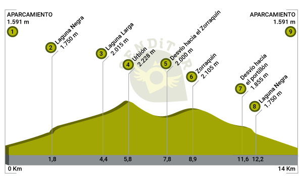
![]() Slope: 1584m
Slope: 1584m
![]() Slope +: 792m
Slope +: 792m
![]() Slope -: 792m
Slope -: 792m
![]() Maximum altitude: 2228m
Maximum altitude: 2228m
![]() Minimum altitude: 1584m
Minimum altitude: 1584m
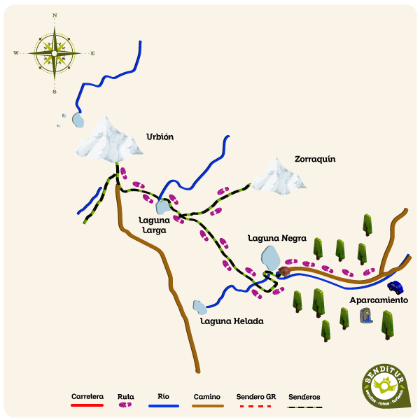
This sketch of the route is not made to scale nor does it contain all the information relating to the area, it is merely indicative.
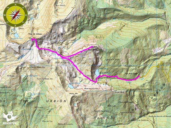
This schematic with the path is approximate and has been created from the derived cartographic base © Instituto Geográfico Nacional "Cuadrante 278-4, 279-3, 316-2 y 317-1 1:25.000"
Senditur has manipulated the tracks to correct the aberrant points that may exist, caused by problems with the reception of the GPS signal. In any case the tracks are always approximate. SENDITUR encourages you to use the new technologies within your reach, using them as support and consultation in your activity, not basing the realization and orientation of the same only and exclusively on them, since they may see their functioning altered by very diverse causes, not functioning correctly and their indications may not be precise.
Find out what to see in...
¿Did you know that...
Antonio Machado located in the Black Lagoon the legend of the Sons of Alvargonzalez of the work The Land of Alvargonzalez. This famous lagoon has been surrounded since time immemorial by the legends and assumptions that together with the surrounding environment make it a very special place where the beauty of its landscapes is mixed with the mysticism of its legends.
Don't miss out...
The place known as Fountains of the Duero which is where this famous river has its birthplace. Shortly before starting the final stretch of the ascent to Urbión, we will find the sign that indicates the detour to follow to reach this place, which is approximately 400m from this point.
From the commitment of SENDITUR with Nature and the respect to the balance of the environment, SENDITUR urges you to travel in a responsible way, with low environmental impact and respecting at all times the Natural, Cultural and Social environment wherever you go.
Besides sharing with all of us your experience on the route we would be grateful if you could write to us to inform us of any erroneous or outdated information you may have found, or simply to let us know what you think at Thank you.
This route has been carried out in the field by SENDITUR on 01-06-2018. The route may vary greatly depending on the time of year, weather conditions and terrain, as well as the actions of third parties and the evolution suffered in the natural environment where it is located. All opinions, advice and/or assessments made by SENDITUR in their descriptions are for guidance only and are subject to and/or refer to the specific conditions of the specific day of the route, referring to that specific day, taken from trained people, with the appropriate experience and with a high level of physical and technical preparation as a reference, as well as correctly equipped.
All the times are approximate and take an orientative character, the stops have not been taken into account, no matter how small they are. All the information related to the route, texts, images, videos, maps, diagrams, tracks, towns, and places of tourist interest are published as a guide, and may not coincide with the current state of each place. Before undertaking any activity, assess your technical knowledge, your physical condition, find out about the weather and the variations that the route may undergo, equip yourself correctly, be prudent and responsible at all times, and do not exceed your capabilities. SENDITUR is not responsible for any misuse or inappropriate use of the comprehensive guides of its routes and/or publications as well as its electronic guides, nor for any variations in their descriptions for the aforementioned reasons, and recommends that everyone be responsible and prudent in carrying out the activity. We also encourage you to read books and specialised guides to complement the information described above.
Continue watching …