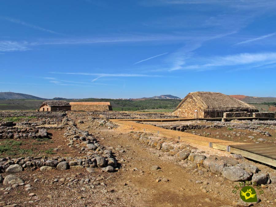
It is located on the hill of La Muela, in the town of Garray, Soria. Numancia, surrounded by thick forests and marshy areas, was built where the rivers Duero and Tera converge, under the protection of the latter and the Merdancho, in a strategic point from which there is a view of a wide plain cradled by the mountains of the Iberian System, from the Pico de Urbión and the Cebollera to the Moncayo. Although the first time that Numancia is mentioned is during the expedition of Cato in 195 BC, it is known that it was founded by the Arevacos at the end of the third century or early second century BC, but before the birth of this city the hill was already occupied during the Chalcolithic or early Bronze Age, about two thousand years before Christ and then lasted a settlement, castro, of the Iron Age until the fourth century BC.

Numantia with its Arevacan population, which according to Apiano was the most powerful and strongest of the Celtiberians, led the resistance of this people against Rome, resistance and struggles that lasted for twenty years until October 134 B.C. General Publius Cornelius Scipio arrived at the site and dedicated himself to isolating it with a siege of seven camps united by a wall. This last siege lasted eleven months during which the Numantines resisted without food, many died of starvation and others, before surrendering, sought death in their own way. The Celtiberian Numantia was razed to the ground in the summer of 133 B.C., but it soon became a city again, this time Roman, who gave it a more regular layout, its houses being built with better quality stone . From the 3rd century onwards the city began to decline and gradually became depopulated until it became a small Visigothic settlement during the 6th and 7th centuries. In the high Middle Ages it was no longer known where Numancia was located, even confusing its location with Soria or Zamora until the archaeological remains of Garray hill were identified with the city of Numancia in the 16th century.

The Archaeological Site of Numancia, through an itinerary of eleven important points, takes the visitor on a journey, going back in time, to a city that is a symbol of heroism and courage. The panel that explains the Roman siege helps to visualize the position of seven of the camps that they placed in the hills around Numancia. A section of the wall of the Celtiberian city has been reconstructed with the northern gate defended by two square wooden towers. Public baths, drains, cisterns, streets with sidewalks, big stones as a footbridge that cross the street making easier not to get muddy, the setting of two houses, one Roman and the other Celtiberian, the framework of its streets and the remains of some houses... give a more than effective visualization of the people who lived here.

The cellar of the Celtiberian house was intended to preserve food as it maintained a stable temperature. Next to the houses were the corrals. It is said that it was customary for their inhabitants to bathe in their own urine, although they were clean and careful in their ways of living, and that their diet was dominated by vegetables, nuts, acorns and that the lack of wine was made up for by "caelia" which was beer extracted from fermented wheat.
On the hill where Numancia was located there is a stone monument with a pedestal, an obelisk and four tombstones on which the dedication to Numancia and its heroes can be read. It was inaugurated by King Alfonso XIII in 1905. Another pedestal is the base of another monument that was intended to be built in 1842 and was not completed due to lack of funds.

It is said that in the spring of 133 B.C., after months of siege, Chief Retogenes and five other Numantines managed to break through the siege and go to the neighbouring Arevacan cities to ask for help, these, for fear of reprisals that the Roman legions could take against them, refused. Only in the city of Lutia did they find the support of some 400 young warriors, but when the boys' own grandparents found out, and in an assembly of elders, they made the decision to warn the besieging Scipio who, moving with part of his troops to the city, captured the young men and cut off their hands.
The visiting hours of the archaeological site of Numancia are
MORE ROUTES AVAILABLE, DON'T MISS IT...
MORE PLACES AVAILABLE, DON'T MISS IT...
Garray can be reached by the N-111 road that connects it to Logroño on one side and to the city of Soria on the other. Garray also has a bus service from Monday to Friday with different timetables covering the route Garray-Soria. The bus stop is the marquee located at Ramón Benito Aceña street, nº 29.
From Garray there is a paved track that goes up from the centre of the village towards Numancia, and after travelling the short distance from Garray, it reaches the entrance of the Numancia Archaeological Site. Once inside, next to the welcome centre, we will have a parking area for our vehicle.
SENDITUR is not responsible for any variation in the information described, as well as for the misuse of its guides and recommends that everyone be responsible and prudent in carrying out the activity. Likewise, we invite you to document yourself with books and specialized guides to complement the information described. From the commitment of SENDITUR with Nature and the respect to the balance of the environment, SENDITUR urges you to travel in a responsible way, with low environmental impact and respecting at all times the Natural, Cultural and Social environment wherever you go. For any suggestion, SENDITUR invites you to send an email to
Continue watching …