Welcome to SENDITUR.COM · paths · routes · tourism


![]() Difficulty-Low
Difficulty-Low
![]() 1:10 h.
1:10 h.
![]() 3.6 km.
3.6 km.
![]() Difficulty-Low
Difficulty-Low
![]() 1:10 h.
1:10 h.
![]() 3.6 km.
3.6 km.
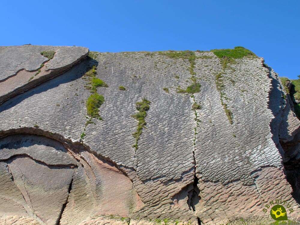
The Cantabrian coast between Zumaia and Deva is an open book with hundreds of pages to read where a film-like landscape awaits us. The Flysch Route as it is known includes, among other things, a remarkable variety of small itineraries, which bring us closer to important corners of this geological treasure. One of these routes is the Georoute of Algorri, where traditions and beliefs are mixed with the special importance of this area of the coast.

The route, which is barely 3.6 km long, starts from the very heart of Zumaia, an obligatory stop on the Way of Saint James, where we can walk along its beautiful promenade or visit the imposing church of Saint Peter, which is more reminiscent of a robust defensive fortress. From there, the route heads towards Itzurun Beach, to plunge deep into the leaves of the impressive encyclopaedia that form the rocky folds that characterise this part of the Basque coast. The vertical walls of the cliffs jealously hide the information about what happened on earth millions of years ago, layer by layer they tell us about climate changes, tectonic folds or apocalyptic meteorite impacts. At the top of the cliff, as if defying the action of gravity and erosion, the Hermitage of San Telmo, towards which we set our course, watches us silently. This hermitage, which is famous for the film in which 8 Basque surnames appear, is home to the patron saint of Zumaia's sailors and marks the starting point of the wildest stretch of the entire route. From here, we will walk along the upper part of the cliff, crossing the Flysch at its highest point, while looking out over the beach we walked on before.

The Point of Algorri awaits us further on to offer us an unbeatable viewpoint from which to contemplate this geological treasure in all its extension. On one side Itzurun and on the other the entire coastline to Deva is shown before us. Under our feet, the impressive tidal plain, which the whim of the tides imposes its criteria, lets us see it and even walk along it thanks to the stairs that descend the cliff. The tides form an important part of the delicate ecosystem that this area has, as well as marking the periods in which we can contemplate the rasa that hides at the bottom of the sea with the high tide. From here, once we have enjoyed the spectacular scenery that this route offers, we can return to the Hermitage of San Telmo, to look out over the cliffs once again, to say goodbye to this enormous encyclopaedia and to go back into the town of Zumaia, to finish this Georoute of Algorri and take the opportunity to visit some of the palaces that this town has, such as the palaces of Foronda and Olazabal.

Legend has it that many years ago, a desperate Zumaiana who had not been able to have children, could not help but cry out into the wind "I want a daughter even if at the age of 20 the devil is going to take her away". After nine months, the woman gave birth to a beautiful baby girl. When she was about to turn 20, the panicked woman locked her up, standing guard day and night. But at the very moment of her twentieth birthday, dark noises came from the room where the young woman was locked up, alerting the woman. When the woman entered the room in terror, she saw a dark figure running away, forcibly dragging her daughter. The whole town rushed to chase them, but what was their surprise when they saw the devil and the girl go into the Cave of Itzurun. Confident of their capture, they rushed to the small cave, but there was no longer any trace of the girl who had disappeared forever.
Zumaia is located on the N-634 between San Sebastian and Bilbao, and can also be reached by following the AP-8, which also links these two Basque capitals. Zumaia also has a bus service that connects it with San Sebastian and nearby towns, as well as with Zumárraga and Ondarroa. At the same time, there is an Euskotren stop in Zumaia itself, which also connects it with San Sebastian and Bilbao. Once there, we will have to go to the centre of the town to walk along the promenade, where we will find car parks where we can leave our vehicle, and at the same time we will arrive at Plaza Amaia, where this route begins.
Quiet stroll without major complications in which we will have to be attentive to the traffic of the urban zone, in addition in the beach we will have to stick to the in force regulation according to the epoch of the year in which we visit the zone.
In the urban layout we will find sources where to be able to give of drink to our friend. It is not a bad idea to take some water with us, in case we lengthen our stay longer than expected in any of the areas of the route, where we will not find water points.
Except for a few more pets that are added to those who live there should not find many more animals. The cattle in addition usually are in delimited parcels, is located in the green meadows of the mountain to which only the GR approaches.
The car park (0h 00min), next to Amaia Square in Zumaia, is the starting point for this route that we are about to take.

Leaving the local port behind us, we go up the landscaped square following the street that flanks it on its right side.

This street, in a notable ascent, takes us directly to the beginning of the promenade that leads to the beach to which we are heading.

Soon we will leave the annoying company of the traffic to continue ascending the Itzurun promenade. Little by little, the beach and its vertical cliffs open up in front of us.

When we reach the limits of the walk we will have the option to face the route by the Beach of Itzurun (0h 10min) in the sense that we choose.

Once we have visited the enormous cliffs that flank this beach and scrutinized its corners, we must return to the promenade. We will walk for a few meters until we find a steep street on our right.

We quickly come across some wide stairs, which we will continue to use to say goodbye to the steep street.

The stairs end almost at once leaving in front of us the beginning of another batch of stairs, this time not as wide as the ones we have just climbed.

This new flight of stairs leads us to another steep street where we will continue the ascent. Luckily the tiresome slope comes to an end at the same time as the street leaves us at a small roundabout with the silhouette of the chapel, towards which we are heading, in front of us.

We should not be confused by the trails that seem to lead directly to the chapel, we must cross the roundabout to continue on a conditioned walk that starts on the other side.

At the moment the walk forks, making it clear which of the two possibilities leads to the chapel.

Our pleasant journey comes to an end very quickly when we come across the old road that goes up from Zumaia to the Hermitage of San Telmo (0h30min).

After contemplating the panoramic views offered by the enclave chosen for this singular chapel, we return to the route following the trail that, as soon as we reach it, descends to the shoulder of the cliff.

A rapid descent leaves us on the same limits of the cliff that we had previously contemplated from the beach.

The marks of the GR-121 will accompany us in part of this section. The vegetation in some areas almost cuts off the trail we are walking on.

Soon we will find the fork in which we will have to decide whether to say goodbye to the GR-121 route to continue walking along the top of the cliff or, on the contrary, follow the GR, and then return along the cliff.

For the time being, we cannot move away from the vertiginous trail that marks it and we continue in search of the end of the vertical wall.
There will be several trails that arise, such as the one we will follow after approaching the Point of Algorri (0h 40min).

Once we reach the edge of the cliff, we go back a few meters to find the trail that best allows us to descend.

Another coastline opens up before us with the imposing cliffs that form the Flysch Route. Once down, we approach another of the improvised viewpoints that allow us to calmly enjoy the landscape around us.

The trail we descended changes course and leads us to the GR-121. When we reach its height we are surprised by some stairs that give us the opportunity to descend to the very shore of the sea.

On the way back to the trail, we will leave behind the steep trail that goes up the side of the mountain, along which the GR follows, to return Zumaia.

Now we are following the stretch of trail that we previously despised and that serves to recover the lost height, climbing again to the top of the Itzurun cliff.

Once we are up we just have to follow the steps that brought us from the Hermitage of San Telmo (0h 55min).

Once there, we will retrace the urban route to reach the parking lot (1h 10min) next to the Amaia Square where we begin this entertaining adventure.
 Distance. 3.6Km
The distance of this route, more than ever, is marked by our starting point and by the variations you make compared to the proposed itinerary.
 Time. 1:10h
This figure does not take into account the time we spend in the various places we pass through, nor if we decide to go down the stairs at the Point of Algorri.
 Time of year
The landscape is spectacular at any time of the year, even with the somewhat rough sea which adds a special atmosphere to the tour. It is advisable to take into account the tides to be able to meet with low tide and thus better appreciate the various formations that are in the area.
 Required equipment
Sports shoes, some water and protection against the sun is, in normal conditions, all we will need initially to do this route. The camera will undoubtedly also be a good companion, not forgetting if time permits the swimsuit and towel to take advantage of the beach we will visit. Consult our list of material and equipment for hiking. Read more.
 Difficulty. Low
Physical
Without a significant distance, it is the short ramps and stairs that we must climb to reach the hermitage of San Telmo, next to the trail that ascends from the lower area of Algorri that will cause us greater difficulties.
Severity of the environment
This route combines urban areas with trails along the cliffs where, as long as prudence and common sense prevail, we should not have any problems. Be careful if there is a strong storm, it may be inadvisable to pass through certain areas.
Orientation
Inside the town there are no marks indicating the way to follow, so we must orientate ourselves with the information we have. Once in the hermitage the marks of the GR 121 join those of the Georute of Algorri although the latter are a little more worn and therefore more complicated to follow. Although we have the advantage that the path to follow is perfectly defined and almost at all times we have visible its course.
 |
 |
 |
 |
 |
| 1-Parking | 0:00h | 3m | 0Km | 30T 560403 4794170 |
| 2- Itzurun Beach | 0:10h | 1m | 0.8Km | 30T 559920 4794456 |
| 3-Hermitage of San Telmo | 0:30h | 29m | 1.5Km | 30T 559852 4794280 |
| 4-Algorri Point | 0:40h | 20m | 2Km | 30T 559384 4794418 |
| 5-Hermitage of San Telmo | 0:55h | 29m | 2.7Km | 30T 559852 4794280 |
| 6-Parking | 1:10h | 3m | 3.6Km | 30T 560403 4794170 |
Coordinates UTM Datum WGS84

 Slope: 282m
 Slope +: 141m
 Slope -: 141m
 Maximum altitude: 35m
 Minimum altitude: 1m

This sketch of the route is not made to scale nor does it contain all the information relating to the area, it is merely indicative.

![]()
This schematic with the path is approximate and has been created from the derived cartographic base © Instituto Geográfico Nacional "Cuadrante 063-2, 1:25.000"
Senditur has manipulated the tracks to correct the aberrant points that may exist, caused by problems with the reception of the GPS signal. In any case the tracks are always approximate. SENDITUR encourages you to use the new technologies within your reach, using them as support and consultation in your activity, not basing the realization and orientation of the same only and exclusively on them, since they may see their functioning altered by very diverse causes, not functioning correctly and their indications may not be precise.


Nosotros hicimos desde Zumaya hasta Deba y es super bonito.


One of the most important funerary monuments of Euskadi


Sanctuary of the Santos Antonios, one of the oldest and most venerated in Vizcaya

Find out what to see in...
¿Did you know that...
As a whole, the Route of the Flysch is a true journey back in time that takes us through more than 60 million years in the history of the earth through the different layers of rock that shape this landscape. These layers are known as Flysch and are authentic hard disks that hold the data of each period of the earth.
Don't miss out...
The Algorri Interpretation Centre where we will have the opportunity to know and understand the environment that surrounds us, the cliffs, the tidal plain, and the different species that populate this part of Guipúzcoa considered a true geological treasure.


From the commitment of SENDITUR with Nature and the respect to the balance of the environment, SENDITUR urges you to travel in a responsible way, with low environmental impact and respecting at all times the Natural, Cultural and Social environment wherever you go.

Besides sharing with all of us your experience on the route we would be grateful if you could write to us to inform us of any erroneous or outdated information you may have found, or simply to let us know what you think at Thank you.
This route has been carried out in the field by SENDITUR on 25-07-2016. The route may vary greatly depending on the time of year, weather conditions and terrain, as well as the actions of third parties and the evolution suffered in the natural environment where it is located. All opinions, advice and/or assessments made by SENDITUR in their descriptions are for guidance only and are subject to and/or refer to the specific conditions of the specific day of the route, referring to that specific day, taken from trained people, with the appropriate experience and with a high level of physical and technical preparation as a reference, as well as correctly equipped.
All the times are approximate and take an orientative character, the stops have not been taken into account, no matter how small they are. All the information related to the route, texts, images, videos, maps, diagrams, tracks, towns, and places of tourist interest are published as a guide, and may not coincide with the current state of each place. Before undertaking any activity, assess your technical knowledge, your physical condition, find out about the weather and the variations that the route may undergo, equip yourself correctly, be prudent and responsible at all times, and do not exceed your capabilities. SENDITUR is not responsible for any misuse or inappropriate use of the comprehensive guides of its routes and/or publications as well as its electronic guides, nor for any variations in their descriptions for the aforementioned reasons, and recommends that everyone be responsible and prudent in carrying out the activity. We also encourage you to read books and specialised guides to complement the information described above.
Continue watching …


.jpg "Go to Sanctuary of Our Lady of Arantzazu")
.jpg "Go to Aizkorri-Aratz Natural Park")


