Welcome to SENDITUR.COM · paths · routes · tourism


![]() Difficulty-Low
Difficulty-Low
![]() 0:35 h.
0:35 h.
![]() 2.4 km.
2.4 km.
![]() Difficulty-Low
Difficulty-Low
![]() 0:35 h.
0:35 h.
![]() 2.4 km.
2.4 km.
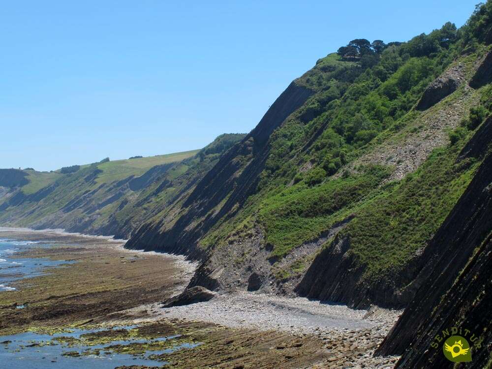
The Portutxiki viewpoint is located at the top of the Sakoneta cliffs, maintaining a delicate balance with the emptiness that rushes under its feet. This area of the coast near the town of Deba offers us a first class seat to enjoy the authentic works of art that nature has gradually created. The Georoute of Sakoneta takes us to this privileged viewpoint, through a small and characteristic valley of the biotope, where we can contemplate and discover the peculiarities of the biodiversity that this area of the coast holds.

The route, which is only 2.4 km long, starts from the car park in the Errotaberri recreational area, and takes us right into a small valley through which a quiet stream flows in search of its nearby end. This part of the itinerary goes through the characteristic Atlantic mixed forest which rarely shares the limelight with the green meadows typical of these lands. The alders, so common on the banks of rivers and streams in other times, have resisted here the eagerness of man to get good land for cultivation and grazing. In addition to these, there are oak and pine woods and the important holm oak forest that we will find in this part of the coast.

A pleasant and entertaining walk that in no way forebodes the rugged landscape we are about to contemplate. Sakoneta Point and the Portutxiki Viewpoint give us the opportunity to look out over the imposing Flysch cliffs which have formed over the years. This is an important marine reserve inhabited by various species that have found the best home in the harsh conditions imposed by the sea, the tidal flats and the cliffs. From here and after dedicating all the necessary time to this beautiful place, we only have to return to our small valley to go to the Errotaberri recreational area with the image, still fresh in our memory, of the unique coast that we have contemplated.

In addition to reaching the viewpoint through the proposed route, we can also do it from Itxaspe and thus cover the stretch of the entire GR 121 that runs closest to the cliffs of the Flysch Route. This option, whose starting point is located between 3 and 4 km from the viewpoint, is somewhat more demanding but it compensates us with a more entertaining landscape.
To reach the Errotaberri recreational area, we will have to follow the N-634 road on its section between Deba and Zumaia. It is on a wide curve that describes the road shortly after passing over the motorway between Bilbao and San Sebastian, if we are coming from Deba or before doing so if we are coming from Zumaia, where we will find the start of the track that will lead us to this recreational area. Once there, all you have to do is follow the track on the left side of the road if you are coming from Deba. We are in front of a narrow asphalted road that descends steeply until it takes us to the car parks of the recreational area where we can park our vehicle.
As in other routes in the park, we will have to assume the regulations regarding pets that are in force in the park and that oblige us to take our dog tied up at all times. For the rest, you will surely enjoy the sensations and stimuli that you will find on this route.
Only at the beginning of the route we will have enough water points so that we do not have any problem in giving him the water he needs.
Except for a few more pets and the dogs that live in the farmhouse where the route begins, it is unlikely that we will encounter any more animals along the way, with the clear exception of the cattle that populate these lands.
The car park (0h 00min) next to the Errotaberri recreational area is the place chosen to start this route.

Right at the entrance of the parking lot, in front of the building that is also in this place, we have the beginning of the path that will lead us to the viewpoint.

As soon as we cross the portlight that closes and delimits this area we will see ourselves following the wooded area that covers the bank of the Errotaberri stream.

The route, well defined, crosses the green fields surrounded by the thick vegetation of the area that for the moment barely provides a gram of shade.

We follow the wide trail that looks more like an old path. The unevenness hardly supposes greater effort to us than to surpass the smooth fields that cross our route.

Soon after, our route enters the vegetation and begins a slightly steeper descent than the ascent we have brought so far.

The trail, more broken and narrower than what we were used to, leads us to a new gate that we have to go through.

Again it gains width and the vegetation gives way to new fields that warn us of the proximity of our destination.

In front of us is a wide meadow that seems to divide our path in two. Nothing could be further from the truth, while the path continues on the left, we will have to border the limits of the meadow on the right.

A narrow trail will serve to cover the few meters that separate us from the viewpoint towards which we are heading.

Before climbing up to the Portutxiki viewpoint (0h 15min), we will come across the course of the GR-121, which runs along this section of its route through Guipúzcoa from Zumaia to Deva, the entire Flysch Geopark.

Once we have contemplated the spectacle offered by this magnificent natural balcony and with the permission of the most adventurous who would have descended to the very limits of the coast, we only have to return to the parking lot (0h 35min), retracing our steps to get here.
 Distance. 2.4Km
Of the different routes to the viewpoint, this is initially the shortest.
 Time. 0:35h
Round trip without counting the time you spend on the scenery from the viewpoint, or the time we spend on the adventure of going down the cliff if we take the risk of checking our agility and expertise.
 Time of year
Except on specific days when there are strong storms and it is not advisable to go near coastal areas, even if they are at a high altitude, or if the fog is present, we can enjoy the magnificent panorama offered by this route all year round. Of course, something we must take into account is the state of the tide, since at high tide the tidal plain is completely hidden under water.
 Required equipment
Under normal conditions the route does not require anything out of the ordinary, other than footwear that is appropriate for the terrain on which we are going to move, some water in case it is necessary and the indispensable protection against the sun, especially on hot days. Of course the camera will be another great adventure companion and if we do not want to miss a detail we can also take a pair of binoculars that allow us to reach the last corner of the landscape that can be observed from the viewpoint. Consult our list of material and equipment for hiking. Read more.
 Difficulty. Low
Physical
Neither the distance nor the slope should put us in difficulty, considering that we are facing a route that allows us to devote the necessary time and take it calmly enough.
Severity of the environment
Except for a short stretch of a slightly steeper path, which also coincides with the area of greatest unevenness where it is easier to slip, the route does not present major problems, except for the environment of the viewpoint. There we have a small area exposed to the cliff where the more adventurous can descend by taking advantage of a rope and some staples that serve as a via ferrata to save part of the vertical wall of the cliff. Those who decide to go down, in addition to this area, will have to take into account the tide to avoid frights and the stony descent that remains, in addition to the chaos of blocks that separate them from the cliff and the possible fall of stones to which they are exposed.
Orientation
Marked at the main crossroads the rest of the route is clearly defined, except for a short stretch through a meadow. The GR-121, as on other routes in the park, also approaches us, so we will come across the marks and indications for this long-distance path next to the viewpoint, together with those that lead to the other recreational area from which you can also get here.
 |
 |
 |
 |
 |
| 1-Parking | 0:00h | 40m | 0Km | 30T 556254 4793087 |
| 2-Sakoneta point | 0:15h | 35m | 1.2Km | 30T 556251 4794080 |
| 3-Parking | 0:35h | 40m | 2.4Km | 30T 556254 4793087 |
Coordinates UTM Datum WGS84

 Slope: 126m
 Slope +: 63m
 Slope -: 63m
 Maximum altitude: 45m
 Minimum altitude: 35m

This sketch of the route is not made to scale nor does it contain all the information relating to the area, it is merely indicative.

![]()
This schematic with the path is approximate and has been created from the derived cartographic base © Instituto Geográfico Nacional "Cuadrante 063-2, 1:25.000"
Senditur has manipulated the tracks to correct the aberrant points that may exist, caused by problems with the reception of the GPS signal. In any case the tracks are always approximate. SENDITUR encourages you to use the new technologies within your reach, using them as support and consultation in your activity, not basing the realization and orientation of the same only and exclusively on them, since they may see their functioning altered by very diverse causes, not functioning correctly and their indications may not be precise.


El tramo entre Zumaya y Deba es una preciosidad


One of the most important funerary monuments of Euskadi


Sanctuary of the Santos Antonios, one of the oldest and most venerated in Vizcaya


Find out what to see in...
¿Did you know that...
The flysch layers were formed in a horizontal position by sediment decantation under the sea. They were then folded and lifted by the Pyrenean collision, which revealed a book of over 50 million years of geological history. At the time of their formation under the sea, the accumulation of sediments was more than 4000 meters thick.
Don't miss out...
The mouth of the Errotaberri stream, the only one of the park's streams that flows at sea level. It is also one of the few direct accesses to the tidal plain that we will have. You will find the mouth not far from the viewpoint, following the course of the GR-121 towards Deba.


From the commitment of SENDITUR with Nature and the respect to the balance of the environment, SENDITUR urges you to travel in a responsible way, with low environmental impact and respecting at all times the Natural, Cultural and Social environment wherever you go.

Besides sharing with all of us your experience on the route we would be grateful if you could write to us to inform us of any erroneous or outdated information you may have found, or simply to let us know what you think at Thank you.
This route has been carried out in the field by SENDITUR on 25-07-2016. The route may vary greatly depending on the time of year, weather conditions and terrain, as well as the actions of third parties and the evolution suffered in the natural environment where it is located. All opinions, advice and/or assessments made by SENDITUR in their descriptions are for guidance only and are subject to and/or refer to the specific conditions of the specific day of the route, referring to that specific day, taken from trained people, with the appropriate experience and with a high level of physical and technical preparation as a reference, as well as correctly equipped.
All the times are approximate and take an orientative character, the stops have not been taken into account, no matter how small they are. All the information related to the route, texts, images, videos, maps, diagrams, tracks, towns, and places of tourist interest are published as a guide, and may not coincide with the current state of each place. Before undertaking any activity, assess your technical knowledge, your physical condition, find out about the weather and the variations that the route may undergo, equip yourself correctly, be prudent and responsible at all times, and do not exceed your capabilities. SENDITUR is not responsible for any misuse or inappropriate use of the comprehensive guides of its routes and/or publications as well as its electronic guides, nor for any variations in their descriptions for the aforementioned reasons, and recommends that everyone be responsible and prudent in carrying out the activity. We also encourage you to read books and specialised guides to complement the information described above.
Continue watching …


.jpg "Go to Sanctuary of Our Lady of Arantzazu")
.jpg "Go to Sanctuary of Loyola")


