Welcome to SENDITUR.COM · paths · routes · tourism

Route of the Guardaviñas
Wine culture and traditions in La Rioja
![]() Difficulty-Low
Difficulty-Low
![]() 2:20 h.
2:20 h.
![]() 8.8 km.
8.8 km.
Wine culture and traditions in La Rioja
![]() Difficulty-Low
Difficulty-Low
![]() 2:20 h.
2:20 h.
![]() 8.8 km.
8.8 km.
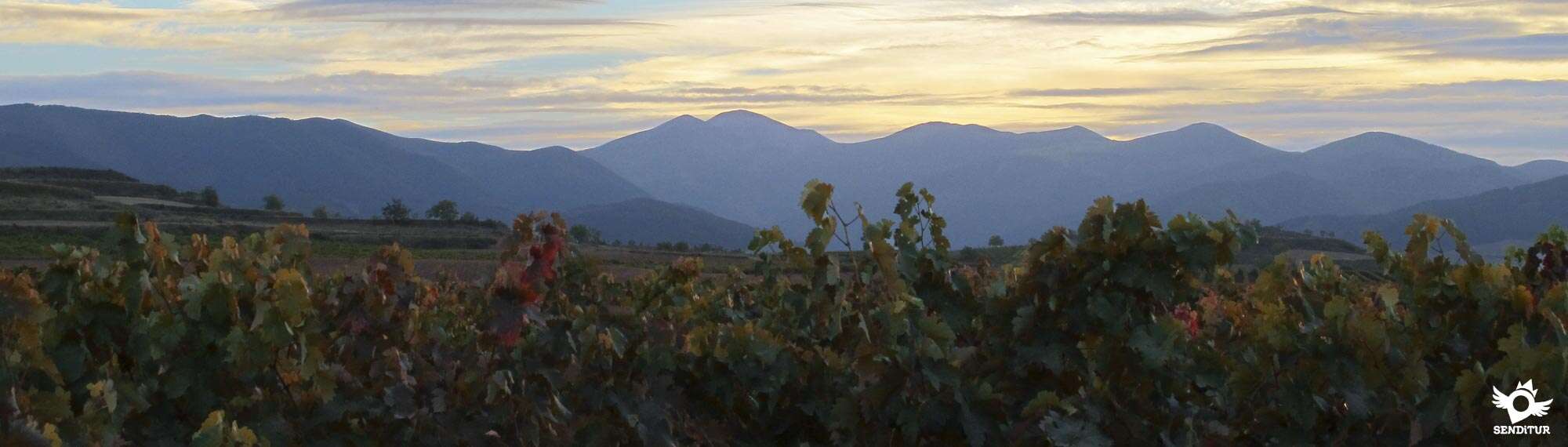
The valley of the River Cardenas, in La Rioja, joins the high mountains of the Sierra of La Demanda in La Rioja with the fertile valley, serving as a base for numerous traditional crops among which could not miss the vine. The Guardaviñas Route runs through a small sample of these traditional architectural buildings closely linked to the wine culture. There are not a few that can be found throughout the territory that includes La Rioja Alta, and without giving them the usefulness for which they were originally conceived, some of them restored for the enjoyment of visitors attracted by the beautiful landscapes that surround them can appreciate the landscape value that these buildings bring.

Others carefully conditioned and used as privileged picnic areas or cellars that in any case serve to maintain one of the ethnographic values of this land. The 8.8 km route takes us along a small part of the Cárdenas river valley, initially between the towns of Badarán and Cárdenas. A route that will serve us to discover a changing landscape whose colorful contrasts come into dispute with the high mountains that watch us expectantly. This part of the route takes us to visit a couple of restored Guardaviñas, the first in a small hillock under the watchful eye of the lush Sierra of Moncalvillo. Almost looking for the limits of the vineyards that here are already beginning to give way to other crops is this Guardaviñas, which undoubtedly served as a good refuge for harvesters who at some point were surprised by the rapid storms that form in this area.

The second Chozo awaits, almost wrapped in vigorous vines, closer to the riverbed, whose proximity leaves its mark on the landscape that surrounds us. The Sierra of La Demanda and the unmistakable mountains that compose it in this area, contribute their special beauty to an already attractive whole, especially in autumn and spring. The last and no less interesting Guardaviñas is well past Badarán, as we head towards the town of Cordovín. This one stands out for his state of conservation and even more for his location in the top of a hill from which we will be able to enjoy spectacular panoramic that they include up to the same Sierra Cantabria and his abrupt silhouette. The vineyards and Badarán are at our feet forming part of the unmistakable and beautiful landscape that marks the character of this area of La Rioja.

Legend has it that in the Guardaviñas live some goblins in charge of watching over the vineyards and taking care that nothing happens to us, the time that they are not in charge of the care of the vineyards they dedicate it to create precious figurines with the unusable vineyards, while they are heated with the embers of the sheaves of vine shoots that burn next to them. With a lot of luck and stealth, it is probable that you will find one of these figurines abandoned by some elf in his flight not to be seen. But the most certain thing is that you will only discover the remains of the bonfire with which they were heated or the sheaves prepared for it.
From Santo Domingo de la Calzada you can get to Badarán by following the LR-204 that runs from Santo Domingo de la Calzada to the town, passing through Villar de Torre, where it is joined by the LR-206 that reaches here from Azofra on the A-12 through Alesanco, where you will find the detour of the LR-312 that connects this town with Cordovín and Badarán. Also in the A-12, but from Nájera, we can reach Badarán by the LR-113, a road that connects Nájera with Salas de los Infantes and where we will find, shortly after leaving Nájera, the detour that leads us to Badarán before passing through Cárdenas. This same road connects Badarán with Berceo and San Millán de la Cogolla respectively. Badarán and Cárdenas have an interurban public transport service between Logroño-Estollo-Logroño every day of the week. Once there the accesses to the route we will find them in the section of road that joins Badarán with Cárdenas, being in the way next to the cemetery of Badarán where we will find the best place to be able to park our vehicle. The access to the other Guardaviñas we will find it in the road that communicates Badarán and Cordovín, the way begins shortly after leaving Badarán.
Ideal route for those who want to get their companion used to the walks, by good roads and without great demands. We must pay close attention if we choose to follow the road on foot, as the narrow and almost non-existent hard shoulder has to add more intense traffic than you would expect from a local road.
The relative short distance should not be an excuse not to take water to him, more even if it is summer, except to our step for Badarán we will not find points of water where to give to drink to our friend.
Watch out during the hunting season, the route goes through a hunting preserve, otherwise except for pets that live in the town, it will not be usual to meet other animals on our way. This does not remove so that we do not worry and let him campar to its wide, the instinct is not lost and it will not be the first nor the last one that is thrown to follow a trail making us pass a bad drink looking for it.
We begin the route next to the cemetery of Badarán, there are two paths that, depending on where we get here, we will find the sign that marks the Route of the Guardaviñas.

Shortly after leaving Cárdenas in the direction of Badarán we will come across the first, but it is in the second, which is in this stretch of road shortly before reaching Badarán, where we will have available a parking area (0h 00min), where we can park our vehicle easily. The itinerary follows the course of the road that comes from the nearby road, leaving behind the parking area.

A short time later we find the first crossroads of the route, here we must choose which path we follow, turning the other into the way back. Taking the path on our right as the outward journey, we will begin an almost imperceptible ascent that runs between vineyards.

This part of the route allows us to contemplate not too far one of the Guardaviñas through which we will pass, which if we had chosen the other option would have been the first to visit. We advance leaving behind the paths that we find following a course almost parallel to that of the road that joins Cárdenas and Badarán.

After going up a small hill in front of us we can already contemplate the still small silhouette of the first Guardaviñas that we will know. We then begin a descent that brings us closer to him, although the path we follow does not give us the impression of taking us directly to the Guardaviñas.

Indeed, before reaching its height we must turn off following the track that starts on our right.

Quickly we find another crossroads where we leave this wide and marked track to follow a path that borders some vineyards giving us the impression of being the access to them.

This path takes us directly to the first Guardaviñas (0h 25min) of the route, protected by the Sierra de Moncalvillo. From here we have to return on our steps to recover the main track by which we arrived.

Once in it, we return to the lost course, meeting again with other paths that we will leave behind us. Once again we arrive at the moment to turn off, leaving the track we were taking and that if we follow it would take us to the nearby road, just at the crossroads where, on the outskirts of Cárdenas, there is another sign indicating the existence of the route.

We continue along the first path on the left that will take us past a lonely hut. This section without further detours leads us directly to the second Guardaviñas (0h 50min) that we will visit, the one that we had previously seen merged with the landscape of vineyards that surrounded us.

From here, a short distance awaits us until we come back to the fork where we had to decide the path to follow. We will quickly come across the car park, the time to decide what to do if we want to go to the next Guardaviñas with our vehicle or continue on foot along the stretch of road that separates us from it.

In any case, all we have to do is get out onto the road and follow it in the direction of Badarán. You have to cross the town following the course of the road until you come to the crossroads that leads to Cordovín. Continuing then this road we will leave behind the locality not deviating for now in any more crossroads.

Shortly after definitively leaving Badarán behind and after passing some agricultural pavilions we will find the steep path we must follow. This way moves away from the road making us gain height quickly, leading us to the last of the Guardaviñas (1h 45min) that we will visit in this route which already some time ago we could see at the top of the hill to which we go.

Here the ones who arrived in their vehicles finish the route, the rest will have to retrace what they walked going to the parking lot (2h 20min) where they left theirs.
 Distance. 8.8Km
The options provided by the route make this figure, more than ever, indicative.
 Time. 2:20h
This is the time that we will need if we decide to carry out in its totality the route on foot, on the contrary if we move in our vehicle until the last Guardaviñas we will save approximately 1h.
 Time of year
Although it is autumn with its special colour and spring or summer the periods in which we can enjoy the maximum splendour of the vineyard and the magnificent landscapes that make up, in winter the proximity of the mountains, surely snowfalls, make this route an interesting walk with its particular charm.
 Required equipment
Comfortable shoes and clothes according to the time of the year, some water especially if it is summer and the photo camera is what we can not miss. It is also interesting to have a map of the area to help us in case of doubt, since there will be enough roads that we will cross and it is easy to get lost. The absence of shade means that in summer it is not too much, apart from the sunscreen, to wear a hat or cap. For those who make the entire journey on foot it is not a bad idea to carry a reflective garment or tape that helps them to be seen more easily by drivers. Consult our list of material and equipment for hiking. Read more.
 Difficulty. Low
Physical
The route around the first two Guardaviñas allows us to enjoy with hardly any physical demands beyond the distance to be covered. Those who decide to walk the distance that separates them with the last one are the ones who will have to assume not only a greater distance but also the ramps of greater unevenness, not supposing great problems for someone accustomed to walking.
Caution
The route if we do it entirely on foot forces us to travel a long stretch by road, being here where we must take extreme precautions. For the rest the wide roads in perfect state will be the ones that take us of a Guardaviñas to another one and except that the rain had made act of presence leaving them very muddy, these usually are in perfect state.
Orientation
There are only a few lonely signs at the entrance to the two paths that lead to the first Guardaviñas, the one that is just outside Cárdenas and the one that leads to the Badarán cemetery. The rest of the crosses, including the beginning of the path that goes up to the last guardaviñas, are not signposted. Even so, the route is relatively easy to follow, as it does not deviate from its trajectory when it encounters other paths, but this does not prevent us from easily getting lost, as the Guards are not seen until they are near them.
 |
 |
 |
 |
 |
| 1-Parking | 0:00h | 615m | 0Km | 30T 516800 4690635 |
| 2-Guardaviñas | 0:25h | 600m | 1.7Km | 30T 518302 4690476 |
| 3-Guardaviñas | 0:50h | 605m | 3.2Km | 30T 517595 4690734 |
| 4-Guardaviñas | 1:45h | 640m | 6.4Km | 30T 515744 4691166 |
| 5-Parking | 2:20h | 615m | 8.8Km | 30T 516800 4690635 |
Coordinates UTM Datum WGS84

 Slope: 288m
 Slope +: 144m
 Slope -: 144m
 Maximum altitude: 640m
 Minimum altitude: 595m

This sketch of the route is not made to scale nor does it contain all the information relating to the area, it is merely indicative.

![]()
This schematic with the path is approximate and has been created from the derived cartographic base © Instituto Geográfico Nacional "Cuadrante 203-3 1:25.000"
Senditur has manipulated the tracks to correct the aberrant points that may exist, caused by problems with the reception of the GPS signal. In any case the tracks are always approximate. SENDITUR encourages you to use the new technologies within your reach, using them as support and consultation in your activity, not basing the realization and orientation of the same only and exclusively on them, since they may see their functioning altered by very diverse causes, not functioning correctly and their indications may not be precise.


Es un paseo muy agradable.


Cradle of the Castilian and pantheon of the seven Castilian heroes


Find out what to see in...
¿Did you know that...
In La Rioja there are as many as 68 Guardaviñas or Chozos, as they are also known, reaching more than 80 in their time of maximum splendour and being the oldest preserved from the mid-nineteenth century.
Don't miss out...
The Monasteries of Yuso and Suso are just a short distance away from this route, where you can immerse yourself in part of the history of this land and discover the Cradle of Castilian as well as enjoying the beauty of the environment that surrounds them and the different architectural styles and works of art of this monumental ensemble.


From the commitment of SENDITUR with Nature and the respect to the balance of the environment, SENDITUR urges you to travel in a responsible way, with low environmental impact and respecting at all times the Natural, Cultural and Social environment wherever you go.

Besides sharing with all of us your experience on the route we would be grateful if you could write to us to inform us of any erroneous or outdated information you may have found, or simply to let us know what you think at Thank you.
This route has been carried out in the field by SENDITUR on 24-10-2016. The route may vary greatly depending on the time of year, weather conditions and terrain, as well as the actions of third parties and the evolution suffered in the natural environment where it is located. All opinions, advice and/or assessments made by SENDITUR in their descriptions are for guidance only and are subject to and/or refer to the specific conditions of the specific day of the route, referring to that specific day, taken from trained people, with the appropriate experience and with a high level of physical and technical preparation as a reference, as well as correctly equipped.
All the times are approximate and take an orientative character, the stops have not been taken into account, no matter how small they are. All the information related to the route, texts, images, videos, maps, diagrams, tracks, towns, and places of tourist interest are published as a guide, and may not coincide with the current state of each place. Before undertaking any activity, assess your technical knowledge, your physical condition, find out about the weather and the variations that the route may undergo, equip yourself correctly, be prudent and responsible at all times, and do not exceed your capabilities. SENDITUR is not responsible for any misuse or inappropriate use of the comprehensive guides of its routes and/or publications as well as its electronic guides, nor for any variations in their descriptions for the aforementioned reasons, and recommends that everyone be responsible and prudent in carrying out the activity. We also encourage you to read books and specialised guides to complement the information described above.
Continue watching …


.jpg "Go to Monastery of Suso")


